Map of Galveston town, Indiana
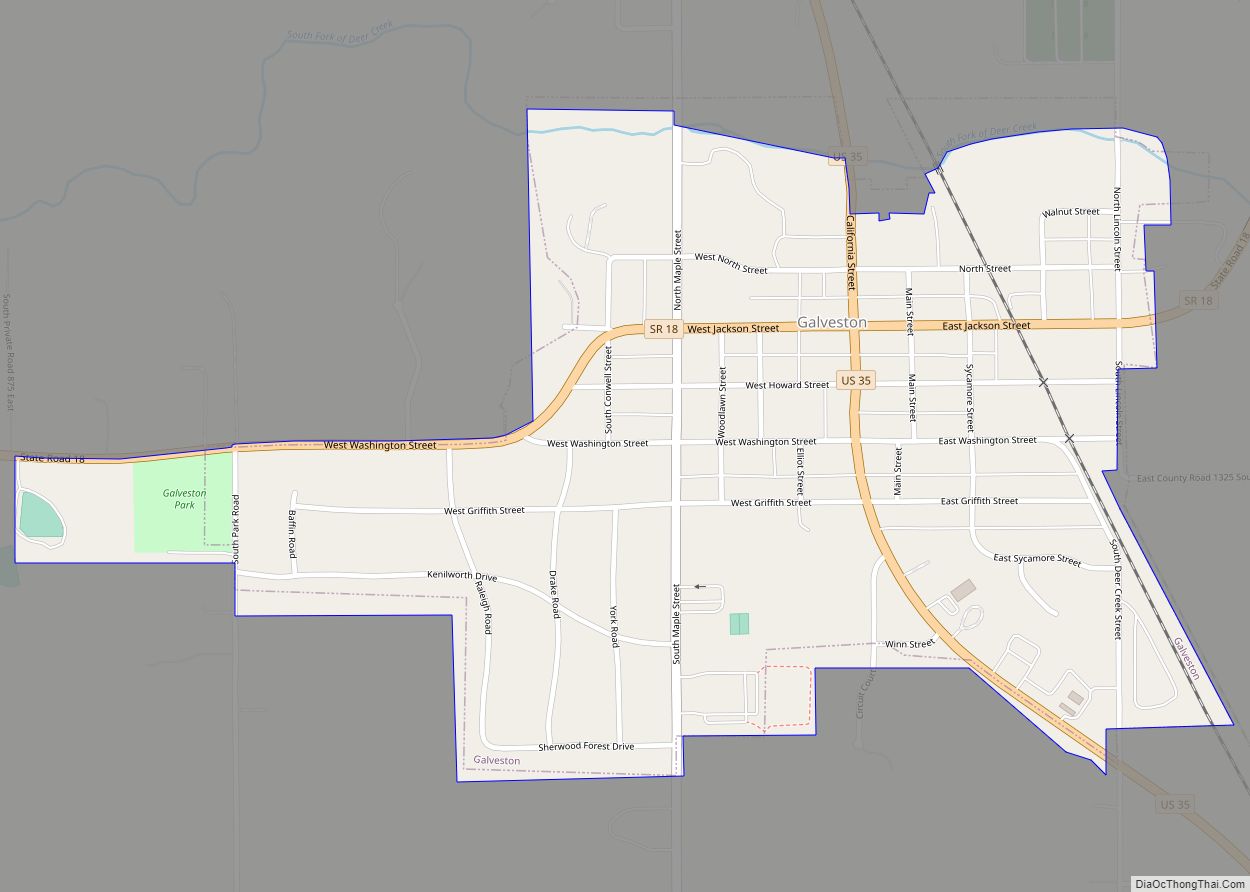
Galveston (/ɡælˈvɛstən/ gal-VES-tən) is a town in Jackson Township, Cass County, Indiana, approximately 7 miles northwest of downtown Kokomo. The population was 1,311 at the 2010 United States Census. Galveston town overview: Name: Galveston town LSAD Code: 43 LSAD Description: town (suffix) State: Indiana County: Cass County Elevation: 801 ft (244 m) Total Area: 0.57 sq mi (1.49 km²) Land ... Read more
Map of Galveston town, Indiana
Map of Galena CDP, Indiana
Galena is a census-designated place (CDP) in Floyd County, Indiana, United States. The population was 1,818 at the 2010 census. The CDP includes the town of Galena as well as the nearby town of Floyds Knobs and their immediate surroundings. Galena CDP overview: Name: Galena CDP LSAD Code: 57 LSAD Description: CDP (suffix) State: Indiana ... Read more
Map of Galena CDP, Indiana
Map of Gaston town, Indiana
Gaston is a town in Washington Township, Delaware County, Indiana, United States. The population was 796 at the 2020 census. It is part of the Muncie, IN Metropolitan Statistical Area. Gaston town overview: Name: Gaston town LSAD Code: 43 LSAD Description: town (suffix) State: Indiana County: Delaware County Elevation: 886 ft (270 m) Total Area: 0.36 sq mi (0.94 km²) ... Read more
Map of Gaston town, Indiana
Map of Gas City
Gas City is a city in Grant County, Indiana, along the Mississinewa River. The population was 5,965 at the 2010 census. Gas City city overview: Name: Gas City city LSAD Code: 25 LSAD Description: city (suffix) State: Indiana County: Grant County Elevation: 856 ft (261 m) Total Area: 5.03 sq mi (13.02 km²) Land Area: 5.03 sq mi (13.02 km²) Water Area: 0.00 sq mi ... Read more
Map of Gas City
Map of Gary city, Indiana
Gary is a city in Lake County, Indiana, United States. The city has been historically dominated by major industrial activity and is home to U.S. Steel’s Gary Works, the largest steel mill complex in North America. Gary is located along the southern shore of Lake Michigan about 25 miles (40 km) east of downtown Chicago, Illinois. ... Read more
Map of Gary city, Indiana
Map of Georgetown town, Indiana
Georgetown is a town in Floyd County, Indiana, United States. The population was 3,805 at the 2020 census. Georgetown town overview: Name: Georgetown town LSAD Code: 43 LSAD Description: town (suffix) State: Indiana County: Floyd County Elevation: 755 ft (230 m) Total Area: 2.19 sq mi (5.68 km²) Land Area: 2.18 sq mi (5.64 km²) Water Area: 0.02 sq mi (0.05 km²) Total Population: 3,805 Population ... Read more
Map of Georgetown town, Indiana
Map of Gentryville town
Gentryville is a town in Jackson Township, Spencer County, in the U.S. state of Indiana. The population was 268 at the 2010 census. Gentryville town overview: Name: Gentryville town LSAD Code: 43 LSAD Description: town (suffix) State: Indiana County: Spencer County Elevation: 466 ft (142 m) Total Area: 0.40 sq mi (1.02 km²) Land Area: 0.39 sq mi (1.02 km²) Water Area: 0.00 sq mi ... Read more
Map of Gentryville town
Map of Geneva town, Indiana
Geneva is a town in Wabash Township, Adams County, Indiana. The population was 1,293 at the time of the 2010 census. Geneva is the location of the Limberlost Cabin, the home of writer and naturalist Gene Stratton-Porter from 1895-1913. Geneva town overview: Name: Geneva town LSAD Code: 43 LSAD Description: town (suffix) State: Indiana County: ... Read more
Map of Geneva town, Indiana
Map of Goshen city, Indiana
Goshen (/ˈɡoʊʃən/ GOH-shən) is a city in and the county seat of Elkhart County, Indiana, United States. It is the smaller of the two principal cities of the Elkhart–Goshen Metropolitan Statistical Area, which in turn is part of the South Bend–Elkhart–Mishawaka Combined Statistical Area. It is located in the northern part of Indiana near the ... Read more
Map of Goshen city, Indiana
Map of Goodland town, Indiana
Goodland is a town in Grant Township in Newton County, Indiana. The population was 1,043 at the 2010 census. Goodland town overview: Name: Goodland town LSAD Code: 43 LSAD Description: town (suffix) State: Indiana County: Newton County Elevation: 725 ft (221 m) Total Area: 0.76 sq mi (1.97 km²) Land Area: 0.76 sq mi (1.97 km²) Water Area: 0.00 sq mi (0.00 km²) Total Population: 980 ... Read more
Map of Goodland town, Indiana
Map of Glenwood town, Indiana
Glenwood is a town in Fairview and Orange townships, Fayette County and Union Township, Rush County in the U.S. state of Indiana. The population was 250 at the 2010 census. Glenwood town overview: Name: Glenwood town LSAD Code: 43 LSAD Description: town (suffix) State: Indiana County: Fayette County, Rush County Elevation: 1,089 ft (332 m) Total Area: ... Read more
Map of Glenwood town, Indiana
Map of Gosport town
Gosport is a town in Wayne Township, Owen County, in the U.S. state of Indiana. The population was 826 at the 2010 census. It is part of the Bloomington, Indiana Metropolitan Statistical Area. Gosport town overview: Name: Gosport town LSAD Code: 43 LSAD Description: town (suffix) State: Indiana County: Owen County Elevation: 696 ft (212 m) Total ... Read more
Map of Gosport town