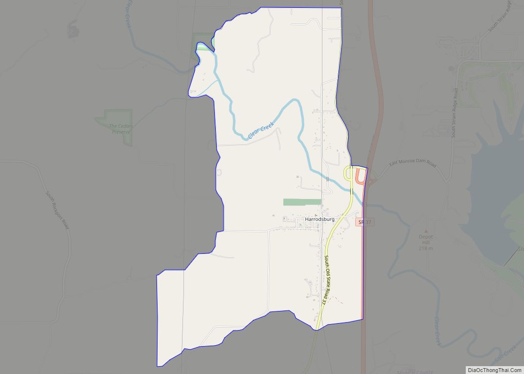
Harrodsburg is an unincorporated community and census-designated place (CDP) in Clear Creek Township, Monroe County, in the U.S. state of Indiana. Its population was 656 at the 2020 census. Harrodsburg CDP overview: Name: Harrodsburg CDP LSAD Code: 57 LSAD Description: CDP (suffix) State: Indiana County: Monroe County Elevation: 558 ft (170 m) Total Area: 4.35 sq mi (11.27 km²) Land ... Read more
Map of US Cities and Places
Harmony is a town in Van Buren Township, Clay County, Indiana, United States. The population was 656 at the 2010 census. It is part of the Terre Haute Metropolitan Statistical Area. Harmony town overview: Name: Harmony town LSAD Code: 43 LSAD Description: town (suffix) State: Indiana County: Clay County Elevation: 719 ft (219 m) Total Area: 0.82 sq mi ... Read more
Haubstadt is the second largest town, after Fort Branch, and fourth largest community in Gibson County, Indiana, United States. The population was 1,577 at the 2010 census. Haubstadt has recently become a bedroom community of Evansville and such, is part of the Evansville, Indiana, Metropolitan Area. Haubstadt town overview: Name: Haubstadt town LSAD Code: 43 ... Read more
Hatfield is an unincorporated census-designated place in Luce Township, Spencer County, in the U.S. state of Indiana. Its population was 813 at the 2010 census. Hatfield CDP overview: Name: Hatfield CDP LSAD Code: 57 LSAD Description: CDP (suffix) State: Indiana County: Spencer County Elevation: 384 ft (117 m) Total Area: 1.17 sq mi (3.03 km²) Land Area: 1.17 sq mi (3.03 km²) Water ... Read more
Hartsville is a town in Haw Creek and Clifty townships, Bartholomew County, Indiana, United States. The population was 362 at the 2010 census. It is part of the Columbus, Indiana metropolitan statistical area. Hartsville town overview: Name: Hartsville town LSAD Code: 43 LSAD Description: town (suffix) State: Indiana County: Bartholomew County Elevation: 761 ft (232 m) Total ... Read more
Hayden (also Hardenburgh or Six Mile) is an unincorporated community and census-designated place (CDP) in central Spencer Township, Jennings County, Indiana, United States. As of the 2020 census it had a population of 501. Hayden CDP overview: Name: Hayden CDP LSAD Code: 57 LSAD Description: CDP (suffix) State: Indiana County: Jennings County Elevation: 620 ft (190 m) ... Read more
Hebron is a town in Boone Township, Porter County, Indiana, United States. The population was 3,724 at the 2010 census. Hebron town overview: Name: Hebron town LSAD Code: 43 LSAD Description: town (suffix) State: Indiana County: Porter County Elevation: 699 ft (213 m) Total Area: 1.93 sq mi (4.98 km²) Land Area: 1.93 sq mi (4.98 km²) Water Area: 0.00 sq mi (0.00 km²) Total Population: ... Read more
Hazleton is a town in White River Township, Gibson County, Indiana, United States. The population was 263 at the 2010 census making it the second smallest community in the county. While having almost no connection to it, it is part of the Evansville, Indiana, Metropolitan Area. Hazleton town overview: Name: Hazleton town LSAD Code: 43 ... Read more
Heritage Lake is an unincorporated community and census-designated place in Floyd Township, Putnam County, in the U.S. state of Indiana. Its population was 2,880 as of the 2010 census. The community is located in eastern Putnam County on the shores of its namesake lake. The lake is 318 acres in size. Heritage Lake CDP overview: ... Read more
Herbst is an unincorporated census-designated place in Franklin Township, Grant County, Indiana, in the United States. As of the 2010 census, the population was 112. Herbst CDP overview: Name: Herbst CDP LSAD Code: 57 LSAD Description: CDP (suffix) State: Indiana County: Grant County Elevation: 856 ft (261 m) Total Area: 0.14 sq mi (0.35 km²) Land Area: 0.14 sq mi (0.35 km²) Water ... Read more
Henryville is a census-designated place (CDP) in Monroe Township, Clark County, in the U.S. state of Indiana. The population was 1,905 at the 2010 census. Henryville is home to Indiana’s oldest state forest, Clark State Forest, and birthplace of entrepreneur Colonel Harland Sanders, whose iconic image appears in the Kentucky Fried Chicken logo and Grammy ... Read more
Hillsboro is a town in Cain Township, Fountain County, Indiana, United States. The population was 538 at the 2010 census. Hillsboro town overview: Name: Hillsboro town LSAD Code: 43 LSAD Description: town (suffix) State: Indiana County: Fountain County Elevation: 705 ft (215 m) Total Area: 0.31 sq mi (0.81 km²) Land Area: 0.31 sq mi (0.81 km²) Water Area: 0.00 sq mi (0.00 km²) Total Population: ... Read more