Map of Lafayette city, Indiana
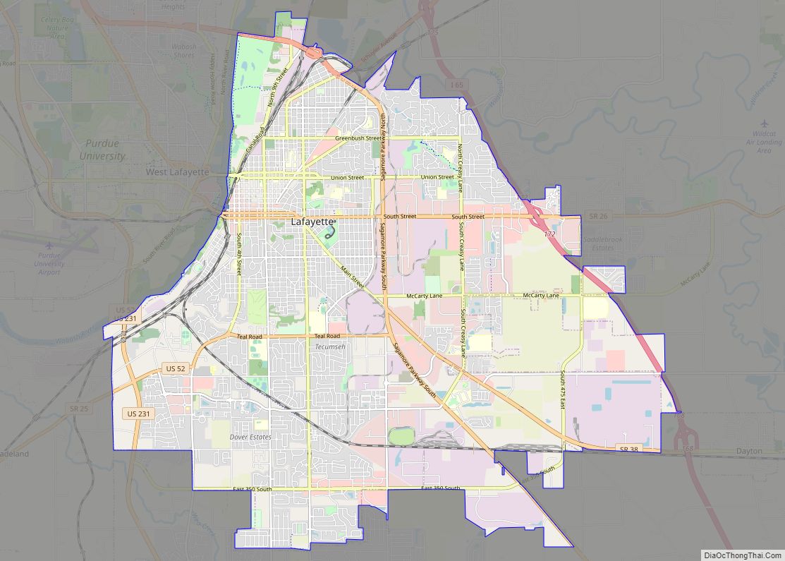
Lafayette (/ˌlɑːfiːˈɛt, ˌlæf-/ LAH-fee-ET, LAF-ee-ET) is a city in and the county seat of Tippecanoe County, Indiana, United States, located 63 miles (101 km) northwest of Indianapolis and 125 miles (201 km) southeast of Chicago. West Lafayette, on the other side of the Wabash River, is home to Purdue University, which contributes significantly to both communities. Together, ... Read more
Map of Lafayette city, Indiana
Map of Ladoga town
Ladoga is a town in Clark Township, Montgomery County, in the U.S. state of Indiana. The population was 1,081 at the 2020 census, up from 985 in 2010. Ladoga town overview: Name: Ladoga town LSAD Code: 43 LSAD Description: town (suffix) State: Indiana County: Montgomery County Elevation: 823 ft (251 m) Total Area: 0.54 sq mi (1.39 km²) Land Area: ... Read more
Map of Ladoga town
Map of Lake Holiday CDP, Indiana
Lake Holiday is an unincorporated community and census-designated place (CDP) in Union Township, Montgomery County, in the U.S. state of Indiana. It is a private community on the banks of its eponymous body of water. As of the 2020 census, the community had a population of 921 residents. The community contains the subdivisions of Holiday ... Read more
Map of Lake Holiday CDP, Indiana
Map of Lake Dalecarlia CDP
Lake Dalecarlia is a census-designated place (CDP) in Lake County, Indiana, United States. The population was 1,355 at the 2010 census. The name comes from the English name of the Dalarna region of Sweden. The community is centered on the lake of the same name, which was completed in the 1920s. Lake Dalecarlia CDP overview: ... Read more
Map of Lake Dalecarlia CDP
Map of Lagro town
Lagro is a town in Lagro Township, Wabash County, in the U.S. state of Indiana. The population was 415 at the 2010 census. Lagro town overview: Name: Lagro town LSAD Code: 43 LSAD Description: town (suffix) State: Indiana County: Wabash County Elevation: 705 ft (215 m) Total Area: 0.61 sq mi (1.57 km²) Land Area: 0.59 sq mi (1.54 km²) Water Area: 0.01 sq mi ... Read more
Map of Lagro town
Map of Lake Village CDP, Indiana
Lake Village is a census-designated place (CDP) in Lake Township, Newton County, in the U.S. state of Indiana. The population was 765 at the 2010 census. Lake Village CDP overview: Name: Lake Village CDP LSAD Code: 57 LSAD Description: CDP (suffix) State: Indiana County: Newton County Elevation: 659 ft (201 m) Total Area: 3.94 sq mi (10.21 km²) Land Area: ... Read more
Map of Lake Village CDP, Indiana
Map of Lake Station city
Lake Station is a city in Lake County, Indiana, United States. The population was 12,572 at the 2010 census. Lake Station city overview: Name: Lake Station city LSAD Code: 25 LSAD Description: city (suffix) State: Indiana County: Lake County Elevation: 620 ft (189 m) Total Area: 8.42 sq mi (21.82 km²) Land Area: 8.29 sq mi (21.47 km²) Water Area: 0.13 sq mi (0.35 km²) Total ... Read more
Map of Lake Station city
Map of Lake Santee CDP
Lake Santee is an unincorporated town and census-designated place in Decatur and Franklin counties, Indiana, United States. As of the 2010 census, it had a population of 820. Lake Santee CDP overview: Name: Lake Santee CDP LSAD Code: 57 LSAD Description: CDP (suffix) State: Indiana County: Decatur County, Franklin County Elevation: 1,015 ft (309 m) Total Area: ... Read more
Map of Lake Santee CDP
Map of Lakeville town, Indiana
Lakeville is a town 11 miles (18 km) south of South Bend in Union Township, St. Joseph County, in the U.S. state of Indiana. The population was 786 at the 2010 Census. It is part of the South Bend–Mishawaka metropolitan area. Lakeville town overview: Name: Lakeville town LSAD Code: 43 LSAD Description: town (suffix) State: Indiana ... Read more
Map of Lakeville town, Indiana
Map of Laketon CDP
Laketon is an unincorporated census-designated place in Pleasant Township, Wabash County, in the U.S. state of Indiana. Laketon CDP overview: Name: Laketon CDP LSAD Code: 57 LSAD Description: CDP (suffix) State: Indiana County: Wabash County Elevation: 755 ft (230 m) Total Area: 1.21 sq mi (3.15 km²) Land Area: 1.05 sq mi (2.73 km²) Water Area: 0.16 sq mi (0.42 km²) Total Population: 606 Population Density: ... Read more
Map of Laketon CDP
Map of Lakes of the Four Seasons CDP
Lakes of the Four Seasons is a census-designated place (CDP) in Lake and Porter counties in the U.S. state of Indiana. The population was 7,033 at the 2010 census. Lakes of the Four Seasons CDP overview: Name: Lakes of the Four Seasons CDP LSAD Code: 57 LSAD Description: CDP (suffix) State: Indiana County: Lake County, ... Read more
Map of Lakes of the Four Seasons CDP
Map of Landess CDP
Landess is an unincorporated community and census-designated place (CDP) in Washington and Van Buren townships, Grant County, Indiana, in the United States. As of the 2010 census it had a population of 188. Landess CDP overview: Name: Landess CDP LSAD Code: 57 LSAD Description: CDP (suffix) State: Indiana County: Grant County Elevation: 866 ft (264 m) Total ... Read more
Map of Landess CDP