Map of Breaux Bridge city
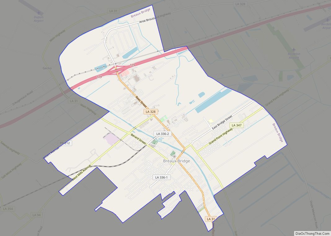
Breaux Bridge (/ˈbroʊˈbrɪdʒ/; French: Pont-Breaux; Cajun French: Pont-(de)-Breaux pronounced [pɔ̃ndbʁo]) is a small city in St. Martin Parish, Louisiana, United States. The population is 8,139 as of the 2010 census, up from 7,281 in 2000. It is part of the Lafayette Metropolitan Statistical Area. Originally dubbed “La Capitale Mondiale de l’Écrevisse,” Breaux Bridge was officially designated ... Read more
Map of Breaux Bridge city
Map of Branch CDP, Louisiana
Branch is an unincorporated community and census-designated place in Acadia Parish, Louisiana, United States. As of the 2010 census, it had a population of 388. Branch is located on LA-35 near the LA-365 intersection, approximately 5 miles (8 km) south of the town of Church Point and 8 miles (13 km) north of the city of Rayne. ... Read more
Map of Branch CDP, Louisiana
Map of Bridge City CDP, Louisiana
Bridge City is an unincorporated community and census-designated place (CDP) in Jefferson Parish, Louisiana, United States. It was established in the 1930s during the construction of the Huey P. Long Bridge over the Mississippi River. The town is located on the south side (referred to as the “West Bank”) of the river. It is part ... Read more
Map of Bridge City CDP, Louisiana
Map of Brownsville CDP, Louisiana
Brownsville is an unincorporated community and census-designated place in Ouachita Parish, Louisiana, United States. Its population was 4,317 as of the 2010 census. Brownsville CDP overview: Name: Brownsville CDP LSAD Code: 57 LSAD Description: CDP (suffix) State: Louisiana County: Ouachita Parish Elevation: 79 ft (24 m) Total Area: 3.48 sq mi (9.00 km²) Land Area: 3.48 sq mi (9.00 km²) Water Area: 0.00 sq mi ... Read more
Map of Brownsville CDP, Louisiana
Map of Brownfields CDP
Brownfields is an unincorporated area and census-designated place (CDP) in East Baton Rouge Parish, Louisiana, United States. The population was 5,401 at the 2010 census. It is part of the Baton Rouge Metropolitan Statistical Area. Brownfields CDP overview: Name: Brownfields CDP LSAD Code: 57 LSAD Description: CDP (suffix) State: Louisiana County: East Baton Rouge Parish ... Read more
Map of Brownfields CDP
Map of Broussard city
Broussard is a city in Lafayette and St. Martin parishes in the U.S. state of Louisiana. The population was 8,197 at the 2010 U.S. census, and 13,417 at the 2020 United States census. Broussard is part of the Lafayette metropolitan statistical area. Broussard city overview: Name: Broussard city LSAD Code: 25 LSAD Description: city (suffix) ... Read more
Map of Broussard city
Map of Bunkie city
Bunkie is a city in Avoyelles Parish, Louisiana, United States. The population was 4,171 at the 2010 census. Bunkie city overview: Name: Bunkie city LSAD Code: 25 LSAD Description: city (suffix) State: Louisiana County: Avoyelles Parish Elevation: 66 ft (20 m) Total Area: 3.04 sq mi (7.87 km²) Land Area: 3.02 sq mi (7.83 km²) Water Area: 0.01 sq mi (0.04 km²) Total Population: 3,346 Population ... Read more
Map of Bunkie city
Map of Bryceland village
Bryceland is a village in Bienville Parish, Louisiana, United States. The population was 108 at the 2010 census. Bryceland village overview: Name: Bryceland village LSAD Code: 47 LSAD Description: village (suffix) State: Louisiana County: Bienville Parish Elevation: 308 ft (94 m) Total Area: 2.34 sq mi (6.06 km²) Land Area: 2.33 sq mi (6.04 km²) Water Area: 0.01 sq mi (0.02 km²) Total Population: 87 Population ... Read more
Map of Bryceland village
Map of Brusly town
Brusly is a town in West Baton Rouge Parish, Louisiana, United States. The population was 2,589 at the 2010 census. It is part of the Baton Rouge Metropolitan Statistical Area. Brusly town overview: Name: Brusly town LSAD Code: 43 LSAD Description: town (suffix) State: Louisiana County: West Baton Rouge Parish Elevation: 23 ft (7 m) Total Area: ... Read more
Map of Brusly town
Map of Calhoun CDP, Louisiana
Calhoun is an unincorporated community and census-designated place in Ouachita Parish, Louisiana, United States. It is named after Archibald Calhoun, who was an original settler and landowner. Its elevation is 177 feet (54 m), and it is located at 32°30′46″N 92°21′31″W / 32.51278°N 92.35861°W / 32.51278; -92.35861 (32.5126469, -92.3584744). Calhoun is unincorporated (no local government) and is ... Read more
Map of Calhoun CDP, Louisiana
Map of Cade CDP
Cade is a census-designated place (CDP) in St. Martin Parish, Louisiana, United States. At the 2014 census estimates, Cade had a population of 1,188; in 2019, the American Community Survey estimated its population was 1,655. With the 2020 U.S. Census the population was 1874. The community is served by a single ZIP code: 70519. The ... Read more
Map of Cade CDP
Map of Buras CDP
Buras is a census-designated place (CDP) in Plaquemines Parish, Louisiana, United States. Its population was 945 at the 2010 census, and 1,109 in 2020. Prior to the 2010 census, Buras was considered to be part of the Buras-Triumph CDP. Buras CDP overview: Name: Buras CDP LSAD Code: 57 LSAD Description: CDP (suffix) State: Louisiana County: ... Read more
Map of Buras CDP