Map of Dodson village, Louisiana
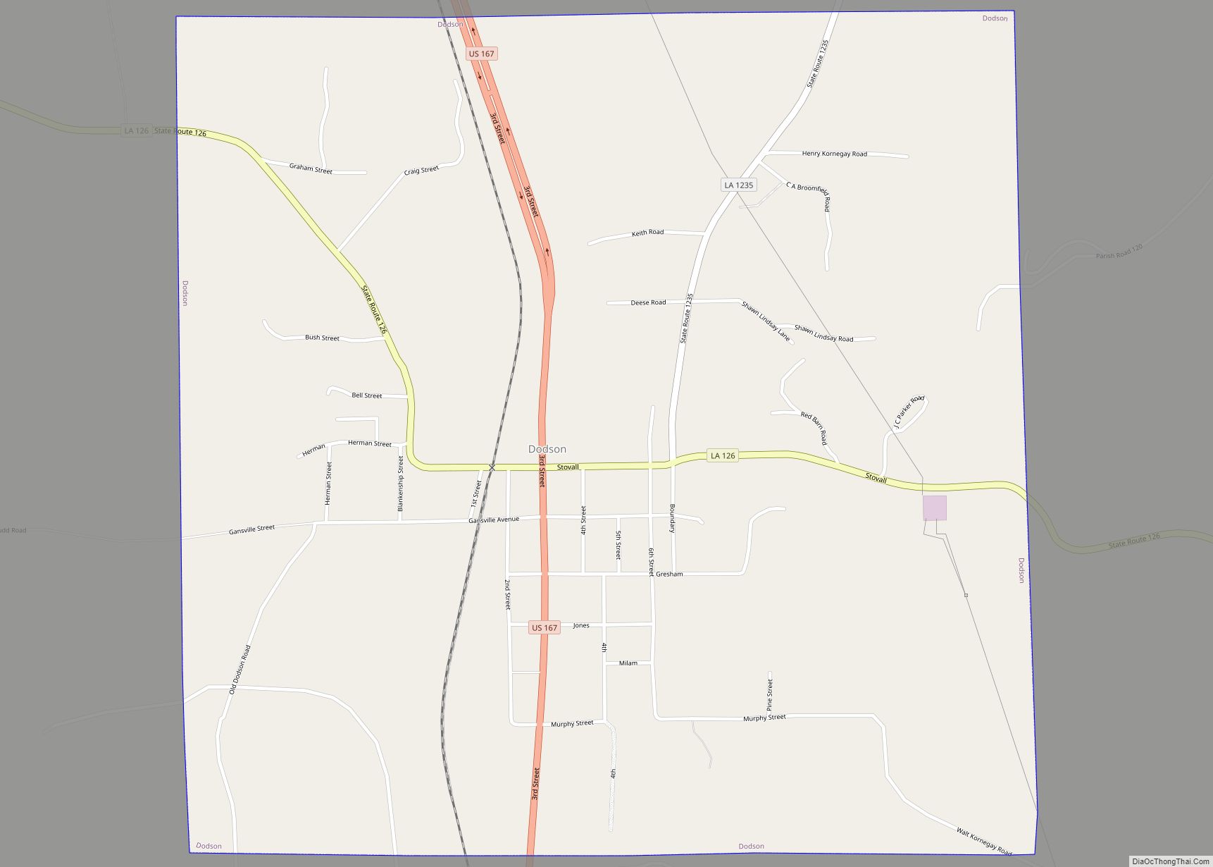
Dodson is a village in Winn Parish, Louisiana, United States. The population was 357 at the 2000 census, which decreased to 337 in 2010. Dodson village overview: Name: Dodson village LSAD Code: 47 LSAD Description: village (suffix) State: Louisiana County: Winn Parish Elevation: 259 ft (79 m) Total Area: 2.25 sq mi (5.84 km²) Land Area: 2.25 sq mi (5.84 km²) Water Area: ... Read more
Map of Dodson village, Louisiana
Map of Dixie Inn village
Dixie Inn is a village in Webster Parish, Louisiana, United States. The population was 352 at the 2000 census. It is located off Interstate 20 at the old Shreveport Road, some twenty-six miles east of Shreveport. Minden, the seat of Webster Parish, is located some three miles to the east. Dixie Inn is part of ... Read more
Map of Dixie Inn village
Map of Deville CDP
Deville is a census-designated place (CDP) in Rapides Parish, Louisiana, United States. It is part of the Alexandria, Louisiana Metropolitan Statistical Area. The population was 1,007 at the 2000 census. Deville CDP overview: Name: Deville CDP LSAD Code: 57 LSAD Description: CDP (suffix) State: Louisiana County: Rapides Parish Elevation: 75 ft (23 m) Total Area: 13.23 sq mi (34.27 km²) ... Read more
Map of Deville CDP
Map of Doyline village
Doyline is a village in southwestern Webster Parish in northwestern Louisiana, United States. The population was 818 at the 2010 census. It is part of the Minden Micropolitan Statistical Area. Under a cited cost-saving realignment plan, the Webster Parish School Board closed Union Elementary School in Doyline in 2011, as Doyline High School absorbed the ... Read more
Map of Doyline village
Map of Downsville village, Louisiana
Downsville is a village in Lincoln and Union parishes in the U.S. state of Louisiana. The population as of the 2010 census was 143, an increase from 118 in the 2000 census. The Lincoln Parish portion of Downsville is part of the Ruston Micropolitan Statistical Area, while the Union Parish portion is part of the ... Read more
Map of Downsville village, Louisiana
Map of Donaldsonville city
Donaldsonville (historically French: Lafourche-des-Chitimachas) is a city in, and the parish seat of Ascension Parish in the U.S. state of Louisiana. Located along the River Road of the west bank of the Mississippi River, it is a part of the Baton Rouge metropolitan statistical area. At the 2020 U.S. census, it had a population of ... Read more
Map of Donaldsonville city
Map of Dubberly village
Dubberly is a village in Webster Parish, Louisiana, United States. The population was 290 at the 2000 census. It is part of the Minden Micropolitan Statistical Area. Former Governor Robert F. Kennon was born in Dubberly in 1902 but reared in Minden. James Burton, a popular rock and roll/Country music guitarist, was born in Dubberly ... Read more
Map of Dubberly village
Map of Dubach town
Dubach is a town in Lincoln Parish, Louisiana, United States. The population was 908 in 2020. Dubach is part of the Ruston micropolitan statistical area. Dubach town overview: Name: Dubach town LSAD Code: 43 LSAD Description: town (suffix) State: Louisiana County: Lincoln Parish Elevation: 164 ft (50 m) Total Area: 1.88 sq mi (4.87 km²) Land Area: 1.82 sq mi (4.71 km²) Water ... Read more
Map of Dubach town
Map of Dry Prong village
Dry Prong is a village in central Grant Parish, Louisiana, United States. It is part of the Alexandria, Louisiana Metropolitan Statistical Area. The population was 436 at the 2010 census. Dry Prong village overview: Name: Dry Prong village LSAD Code: 47 LSAD Description: village (suffix) State: Louisiana County: Grant Parish Elevation: 230 ft (70 m) Total Area: ... Read more
Map of Dry Prong village
Map of East Hodge village
East Hodge is a village in Jackson Parish, Louisiana, United States. The population was 289 at the 2010 census, down from 366 at the 2000 census. It is part of the Ruston Micropolitan Statistical Area. East Hodge village overview: Name: East Hodge village LSAD Code: 47 LSAD Description: village (suffix) State: Louisiana County: Jackson Parish ... Read more
Map of East Hodge village
Map of Duson town
Duson is a town in Acadia and Lafayette parishes in the U.S. state of Louisiana. The town was named after Curley Duson, a sheriff of St. Landry Parish. At the 2010 U.S. census, the town had a population of 1,716; in 2020, at the population estimates program, its population was 1,761. The Lafayette Parish portion ... Read more
Map of Duson town
Map of Dulac CDP
Dulac is a census-designated place (CDP) in Terrebonne Parish, Louisiana, United States. The population was 1,241 in 2020. It is part of the Houma–Bayou Cane–Thibodaux metropolitan statistical area. Dulac CDP overview: Name: Dulac CDP LSAD Code: 57 LSAD Description: CDP (suffix) State: Louisiana County: Terrebonne Parish Elevation: 3 ft (0.9 m) Total Area: 18.15 sq mi (47.02 km²) Land Area: ... Read more
Map of Dulac CDP