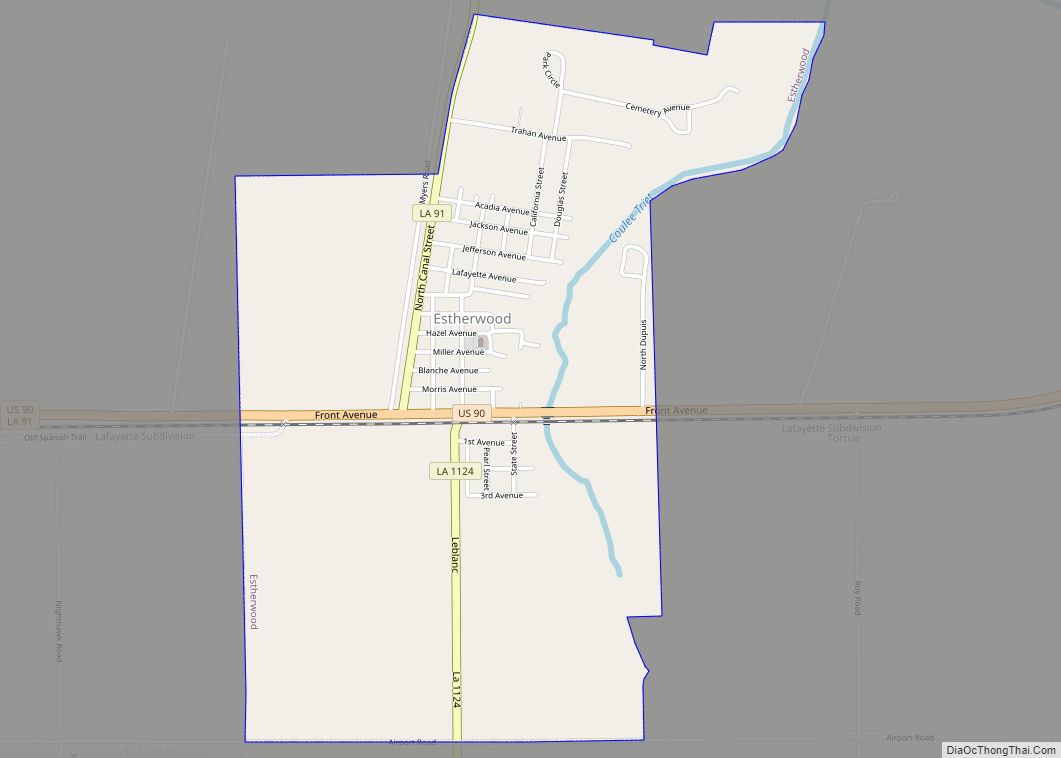
Estherwood is a village in Acadia Parish, Louisiana, United States. The population was 889 at the 2010 census. It is part of the Crowley Micropolitan Statistical Area. Estherwood village overview: Name: Estherwood village LSAD Code: 47 LSAD Description: village (suffix) State: Louisiana County: Acadia Parish Elevation: 16 ft (5 m) Total Area: 1.86 sq mi (4.83 km²) Land Area: 1.86 sq mi ... Read more
Map of US Cities and Places
Estelle is a census-designated place (CDP) in Jefferson Parish, Louisiana, United States. The population was 17,952 in 2020. It is part of the New Orleans–Metairie–Kenner metropolitan statistical area. Estelle is located south of Marrero; the urbanized areas of the communities meet, and some businesses in Estelle list their addresses as “Marrero”. The Jean Lafitte National ... Read more
Erwinville is an unincorporated community and census-designated place in West Baton Rouge Parish, Louisiana, United States. Its population was 2,192 as of the 2010 census. U.S. Route 190 passes through the community. Erwinville CDP overview: Name: Erwinville CDP LSAD Code: 57 LSAD Description: CDP (suffix) State: Louisiana County: West Baton Rouge Parish Elevation: 23 ft (7 m) ... Read more
Farmerville is a town in and the parish seat of Union Parish, Louisiana, United States. It has also been known as Farmersville. The population was 3,860 at the 2010 census. It is part of the Monroe Metropolitan Statistical Area. The town is spread about Lake D’Arbonne, a popular fishing and boating waterway. Farmerville town overview: ... Read more
Evergreen is a town in Avoyelles Parish, Louisiana, United States. The population was 310 at the 2010 census. Evergreen is located east of Bunkie. Evergreen town overview: Name: Evergreen town LSAD Code: 43 LSAD Description: town (suffix) State: Louisiana County: Avoyelles Parish Elevation: 62 ft (19 m) Total Area: 1.02 sq mi (2.65 km²) Land Area: 1.02 sq mi (2.65 km²) Water Area: ... Read more
Eunice is a city in Acadia and St. Landry parishes in the U.S. state of Louisiana. The 2010 census placed the population at 10,398, a decrease of 1,101, or 9.5 percent, from the 2000 tabulation of 11,499. The St. Landry Parish portion of Eunice is part of the Opelousas–Eunice Micropolitan Statistical Area, while the Acadia ... Read more
Fifth Ward is an unincorporated community and census-designated place in Avoyelles Parish, Louisiana, United States. As of the 2010 census, it had a population of 800. Fifth Ward is located along Louisiana Highway 1, 7 miles (11 km) west of Marksville, the parish seat, and 23 miles (37 km) southeast of Alexandria. Fifth Ward CDP overview: Name: ... Read more
Ferriday is a town in Concordia Parish, which borders the Mississippi River and is located on the central eastern border of Louisiana, United States. With a population of 3,511 at the 2010 census, it is an African-American majority town. The town claims to have produced more famous people per square mile than any other in ... Read more
Fenton is a village in Jefferson Davis Parish, Louisiana, United States. The population was 379 at the 2010 census. It is part of the Jennings Micropolitan Statistical Area. Thomas A. “Tom” Greene, a former state senator from Iberville Parish, graduated in 1966 from Fenton High School. Fenton village overview: Name: Fenton village LSAD Code: 47 ... Read more
Folsom is a village in St. Tammany Parish, Louisiana, United States. The population was 716 at the 2010 census. The town is named after the wife of Grover Cleveland, Frances Folsom. It is part of the New Orleans–Metairie–Kenner Metropolitan Statistical Area. Folsom village overview: Name: Folsom village LSAD Code: 47 LSAD Description: village (suffix) State: ... Read more
Florien is a village in Sabine Parish, Louisiana, United States. The population was 633 at the 2010 census, down from 692 at the 2000 census. The village is home to the annual Sabine Free State Festival, celebrating the village’s history as part of the Sabine Neutral Strip. Florien village overview: Name: Florien village LSAD Code: ... Read more
Fisher is a village in Sabine Parish, Louisiana, United States. The population was 230 at the 2010 census, down from 268 in 2000. Fisher village overview: Name: Fisher village LSAD Code: 47 LSAD Description: village (suffix) State: Louisiana County: Sabine Parish Elevation: 344 ft (105 m) Total Area: 0.62 sq mi (1.60 km²) Land Area: 0.62 sq mi (1.60 km²) Water Area: 0.00 sq mi ... Read more