Blaine County is a county located in the U.S. state of Oklahoma. As of the 2020 census, the population was 8,735. Its county seat is Watonga. Part of the Cheyenne-Arapaho land opening in 1892, the county had gained rail lines by the early 1900s and highways by the 1930s. The county was named for James G. Blaine, an American politician who was the Republican presidential candidate in 1884 and Secretary of State under President Benjamin Harrison.
| Name: | Blaine County |
|---|---|
| FIPS code: | 40-011 |
| State: | Oklahoma |
| Founded: | May 2, 1890 |
| Named for: | James G. Blaine |
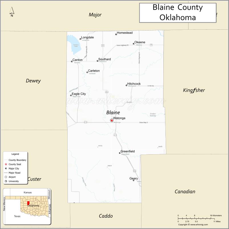
| Seat: | Watonga |
| Largest city: | Watonga |
| Total Area: | 939 sq mi (2,430 km²) |
| Land Area: | 928 sq mi (2,400 km²) |
| Total Population: | 8,735 |
| Population Density: | 9.3/sq mi (3.6/km²) |
| Time zone: | UTC−6 (Central) |
| Summer Time Zone (DST): | UTC−5 (CDT) |
| Website: | blaine.okcounties.org |
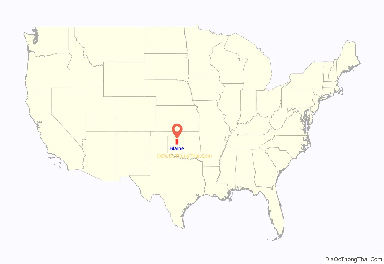
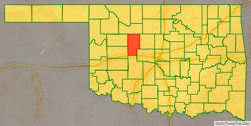
Blaine County location map. Where is Blaine County?
History
Blaine County was one of several counties created by the Land Run of 1892. It was designated as county “C” beginning in 1890 before the land run. According to one account, the designation “C” remained until the first public elections in 1892. When the time came to choose another name for the county, there seemed to be roughly equal support for two military heroes: “Sheridan” and “Custer”. Before voting began, the chairman gave a stirring speech proposing Blaine, who had recently died, and who was a local favorite. The majority of voters swung behind Blaine’s name, which was ultimately chosen for County C. The area was settled by Creek and Seminole, whom the federal government relocated to the area in the 1820s and 1830s. The Cheyenne and Arapaho tribes were relocated to the area from Colorado in 1869, after the Reconstruction Treaties of 1866 had taken the land back from the Creek and Seminole.
The land run was held after giving members of the tribe allotments of 160 acres (0.65 km) each.
A post office was established in the county seat of Watonga, the same year as the land run. The Enid and Anadarko Railway and the Blackwell, Enid and Southwestern Railroad both ran lines through the county from 1901 to 1903. The Blaine County Courthouse was built in 1906.
The town of Geary, which also received a post office in the same year as the land run, became an agricultural trade center in the county, and had a population of 2,561 by 1902. The town was home to “the oldest bank in Blaine County.” Okeene was also established in the year of the land run and was surrounded by farmers of German descent.
In 1904, Blaine County was the birthplace of voice actor Clarence Nash, the original voice of Disney’s Donald Duck. The county’s population was 17,227 in 1907, and rose to 17,960 in 1910. It had declined to 15,875 by 1920.
The U.S. highway system reached Oklahoma in 1926. U.S. Highways 270 and 281 were constructed through Blaine County. The county was also served by the Postal Highway as early as 1912; it later became part of U.S. Highway 66.
The county’s population peaked at 20,452 in 1930. New Deal programs such as the Civilian Conservation Corps employed county residents and built Roman Nose State Park, which opened in 1937.
By the 21st century, the county had a population of 11,976. Between 2010 and 2020 the population of Blaine County declined by 26.9 percent to 8,735. It was the largest decrease in percentage terms during the decade of any Oklahoma county. Although population decreases are typical of most rural Oklahoma countries, much of the population decline of Blaine County from 2010 to 2020 was due to the closing in 2010 of a prison which was the largest employer in the county.
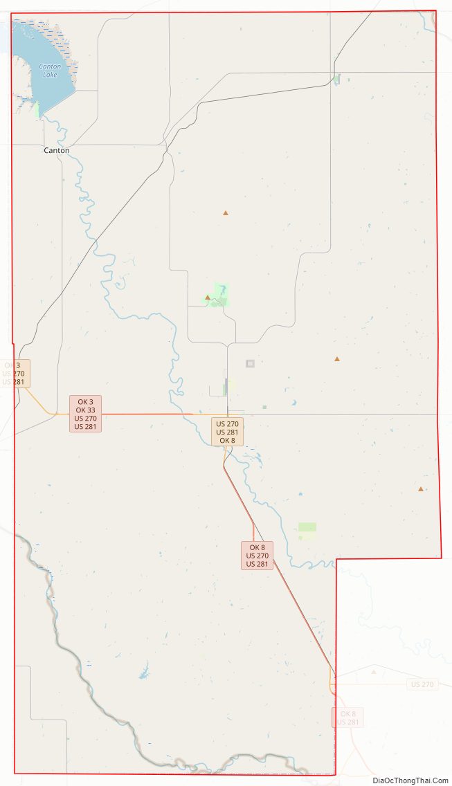
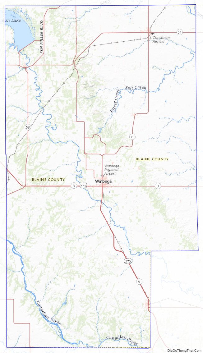
Blaine County Road Map
Geography
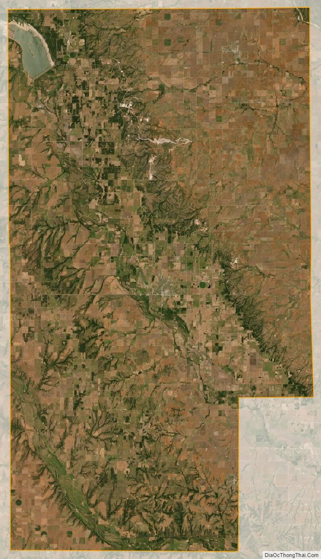
According to the U.S. Census Bureau, the county has a total area of 939 square miles (2,430 km), of which 928 square miles (2,400 km) is land and 10 square miles (26 km) (1.1%) is water. The northeastern half of the county is located on the western edge of the Red Bed Plains while the southwestern half lies in the Gypsum Hills. The North Canadian River runs through the county from northwest to southeast.
The county includes the largest lake in western Oklahoma, Canton Lake.
The county seat of Watonga hosts an annual cheese festival in October, celebrating the city’s cheese factory.
Major highways
- U.S. Highway 270
- U.S. Highway 281
- State Highway 3
- State Highway 8
- State Highway 51
- State Highway 58
Adjacent counties
- Major County (north)
- Kingfisher County (east)
- Canadian County (southeast)
- Caddo County (south)
- Custer County (southwest)
- Dewey County (northwest)
Blaine County Topographic Map
Blaine County Satellite Map
Blaine County Outline Map

See also
Map of Oklahoma State and its subdivision:- Adair
- Alfalfa
- Atoka
- Beaver
- Beckham
- Blaine
- Bryan
- Caddo
- Canadian
- Carter
- Cherokee
- Choctaw
- Cimarron
- Cleveland
- Coal
- Comanche
- Cotton
- Craig
- Creek
- Custer
- Delaware
- Dewey
- Ellis
- Garfield
- Garvin
- Grady
- Grant
- Greer
- Harmon
- Harper
- Haskell
- Hughes
- Jackson
- Jefferson
- Johnston
- Kay
- Kingfisher
- Kiowa
- Latimer
- Le Flore
- Lincoln
- Logan
- Love
- Major
- Marshall
- Mayes
- McClain
- McCurtain
- McIntosh
- Murray
- Muskogee
- Noble
- Nowata
- Okfuskee
- Oklahoma
- Okmulgee
- Osage
- Ottawa
- Pawnee
- Payne
- Pittsburg
- Pontotoc
- Pottawatomie
- Pushmataha
- Roger Mills
- Rogers
- Seminole
- Sequoyah
- Stephens
- Texas
- Tillman
- Tulsa
- Wagoner
- Washington
- Washita
- Woods
- Woodward
- Alabama
- Alaska
- Arizona
- Arkansas
- California
- Colorado
- Connecticut
- Delaware
- District of Columbia
- Florida
- Georgia
- Hawaii
- Idaho
- Illinois
- Indiana
- Iowa
- Kansas
- Kentucky
- Louisiana
- Maine
- Maryland
- Massachusetts
- Michigan
- Minnesota
- Mississippi
- Missouri
- Montana
- Nebraska
- Nevada
- New Hampshire
- New Jersey
- New Mexico
- New York
- North Carolina
- North Dakota
- Ohio
- Oklahoma
- Oregon
- Pennsylvania
- Rhode Island
- South Carolina
- South Dakota
- Tennessee
- Texas
- Utah
- Vermont
- Virginia
- Washington
- West Virginia
- Wisconsin
- Wyoming