Blanco County (Spanish: “white”, /ˈblæŋkoʊ/ BLANG-koh) is a United States county located in the U.S. state of Texas. It is located in Central Texas and its county seat is Johnson City.
As of the 2020 census, the population was 11,374.
The county is named for the Blanco River that traverses the county.
| Name: | Blanco County |
|---|---|
| FIPS code: | 48-031 |
| State: | Texas |
| Founded: | February 12, 1858 |
| Named for: | Blanco River |
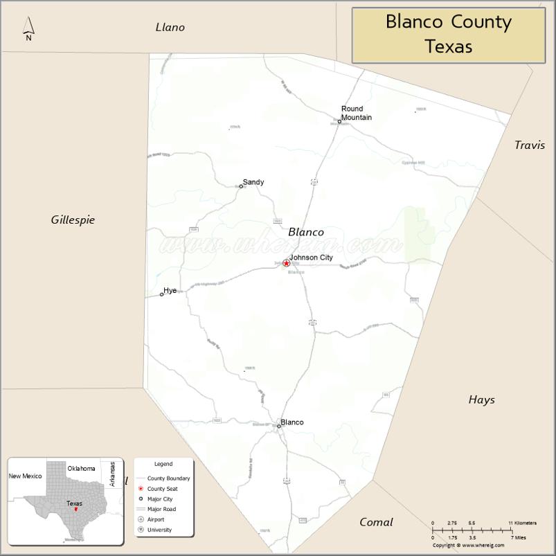
| Seat: | Johnson City |
| Largest city: | Blanco |
| Total Area: | 713 sq mi (1,850 km²) |
| Land Area: | 709 sq mi (1,840 km²) |
| Total Population: | 11,374 |
| Population Density: | 16/sq mi (6.2/km²) |
| Time zone: | UTC−6 (Central) |
| Summer Time Zone (DST): | UTC−5 (CDT) |
| Website: | www.co.blanco.tx.us |
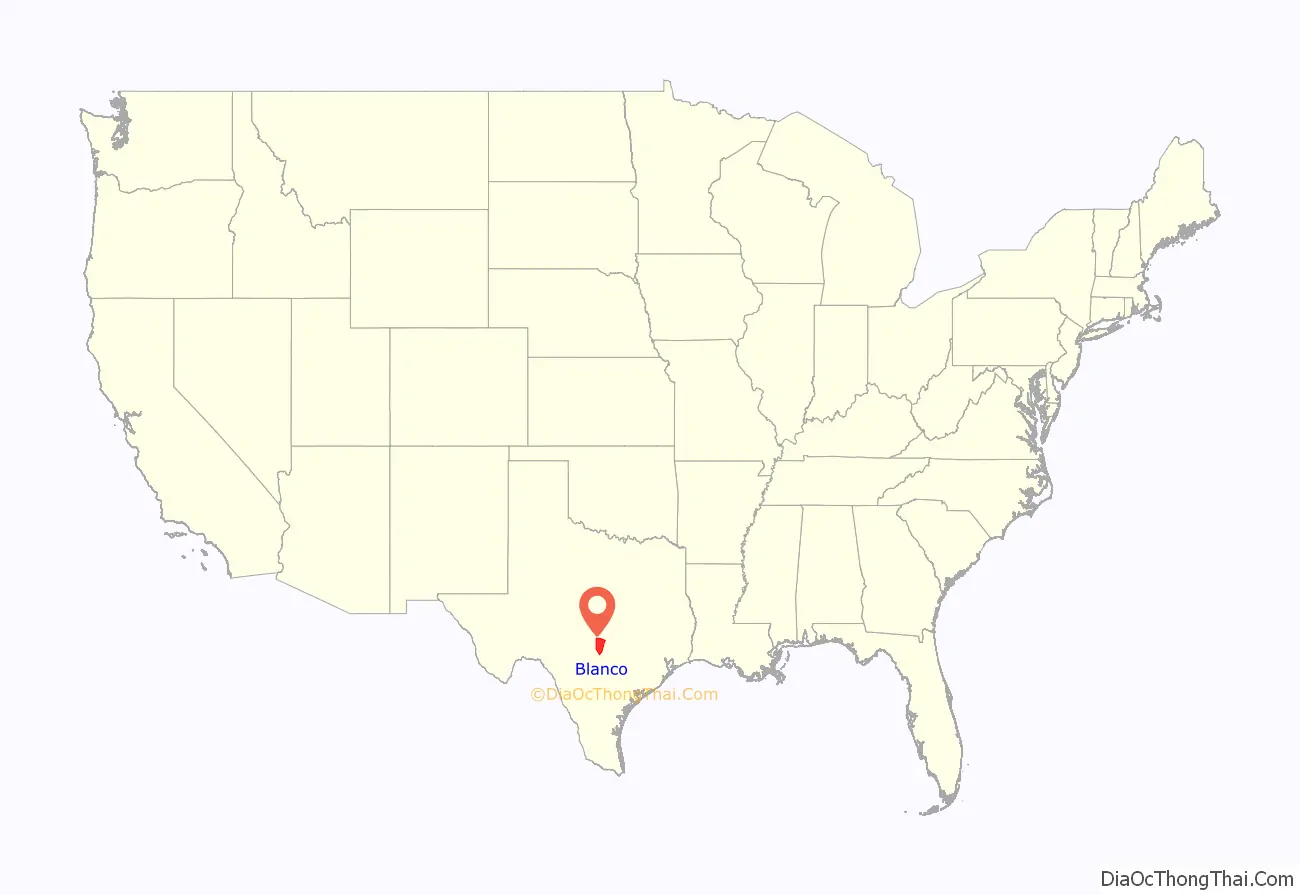
Blanco County location map. Where is Blanco County?
History
- 1150 AD Indigenous peoples first inhabitants, possible ancestors of the Lipan Apache.
- 1721 José de Azlor y Virto de Vera names the Blanco River.
- 1826 Benjamin Milam is given a contract to settle 300 families between the Colorado and Guadalupe rivers.
- 1836 Comanches claim all land in Blanco County.
- 1847 Meusebach–Comanche Treaty
- 1850s Samuel Ealy Johnson, Sr., grandfather of President Lyndon B. Johnson, and his brother Jesse Thomas Johnson, set up a cattle business in Johnson City. The town is named after their nephew James Polk Johnson. The Johnson family emigrated from Alabama.
- 1854-1855 Captain James Hughes Callahan and Eli Clemens Hinds become Blanco’s first white settlers. Joseph Bird establishes Birdtown, now Round Mountain. General John D. Pitts, Judge William S. Jones, Andrew M. Lindsay, James Hughes Callahan and F.W. Chandler charter the Pittsburgh Land Company. They purchase the league granted to Horace Eggleston by the government of Coahuila y Tejas in 1835 and lay out the town of Pittsburgh, Texas, named for General Pitts, across the river from the site of future Blanco.
- 1858, February 12 – Blanco County is formed from parts of Comal, Hays, Burnet and Gillespie, and is named for the Blanco River. County seat is also named Blanco.
- 1860 Population of 1218, includes 98 slaves. Settlers are mostly Anglo-Saxon Protestants hailing from Tennessee and Alabama. Agriculture and livestock are central to the economy.
- 1861 County votes against secession from the Union.
- 1862 Legislature establishes Kendall from part of Blanco southwestern border. Legislature in turn incorporates parts of Hays and Burnet into Blanco.
- 1885 Replacement of courthouse by limestone structure now known as “The Old Courthouse”.
- 1883 Blanco High School is chartered.
- 1890 Johnson City becomes the new county seat.
- 1910 Cotton becomes one of the county’s most important crops.
- 1900-1930 County farmers diversify into peanuts, peaches, pecans, pears, plums, grapes, and figs.
- 1915 Samuel Ealy Johnson, Jr. and his wife Rebekah Baines Johnson, parents of President Lyndon Baines Johnson, move into their home in Johnson City with their five children, Lucia, Sam Houston, Josefa, Rebekah, and Lyndon Baines Johnson.
- 1929 More than 20,000 peach and pecan trees harvested in the county.
- 1933-1942 Civilian Conservation Corps public work relief program helps improve county parks and infrastructure.
- 1934 Blanco State Park opens.
- 1937 Lyndon Baines Johnson launches his first campaign for Congress from the east porch of the family’s Johnson City home.
- 1938 LBJ becomes a fierce advocate for rural electrification. First light bulb turned on in rural Blanco County.
- 1960s Lyndon B. Johnson becomes Vice President of the United States and subsequently President of the United States. Tourism becomes an important industry.
- 1970 Pedernales Falls State Park opens to the public.
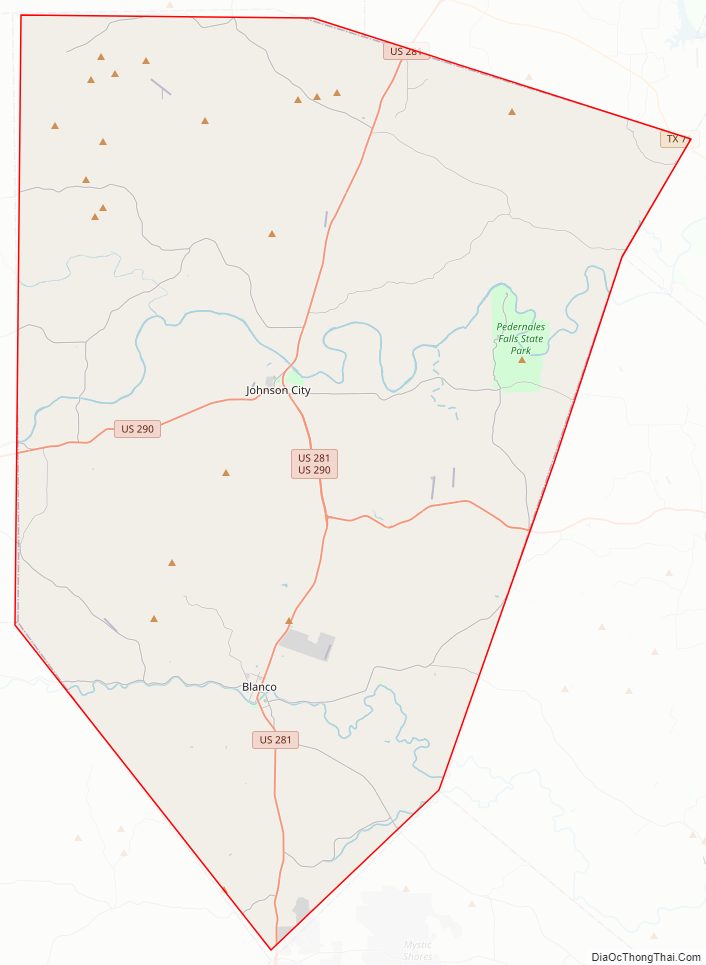
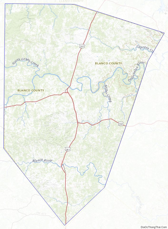
Blanco County Road Map
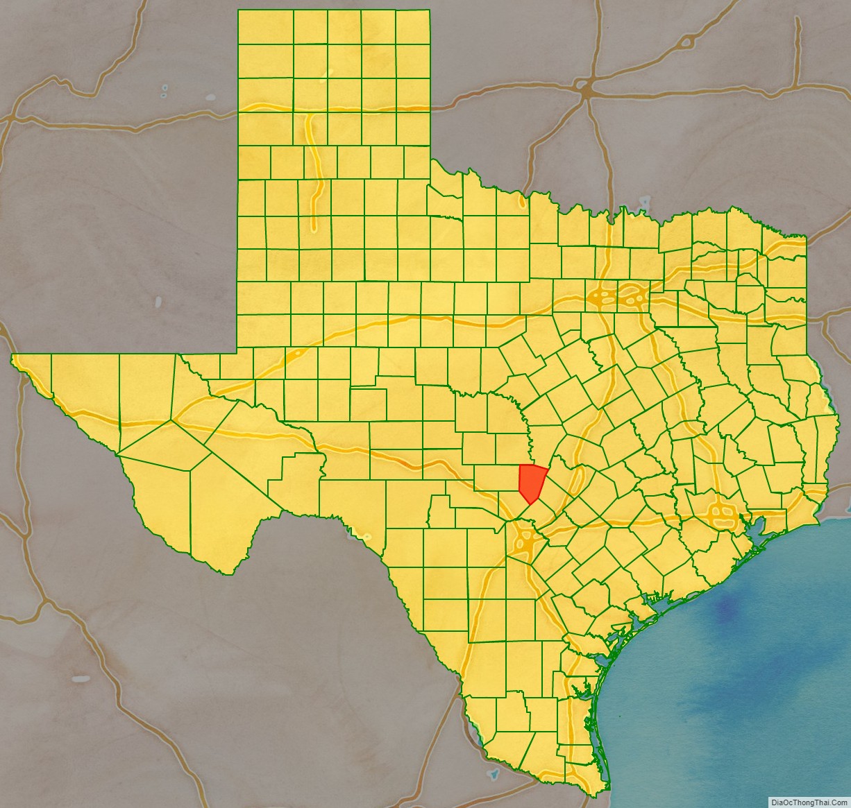
Geography
According to the U.S. Census Bureau, the county has a total area of 713 square miles (1,850 km), of which 709 square miles (1,840 km) is land and 4.2 square miles (11 km) (0.6%) is water.
Blanco County is located in the Hill Country of central Texas, west of Austin and north of San Antonio. Two significant rivers, the Blanco and the Pedernales, flow through the county.
Major highways
- U.S. Highway 281
- U.S. Highway 290
- Ranch Road 1
Adjacent counties
- Burnet County (north)
- Travis County (northeast)
- Hays County (east)
- Comal County (southeast)
- Kendall County (southwest)
- Gillespie County (west)
- Llano County (northwest)
National protected area
- Lyndon B. Johnson National Historical Park (part)
Texas Parklands
- Pedernales Falls State Park
Blanco County Topographic Map
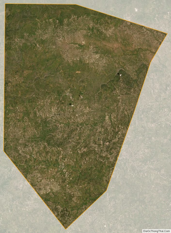
Blanco County Satellite Map
Blanco County Outline Map

See also
Map of Texas State and its subdivision:- Anderson
- Andrews
- Angelina
- Aransas
- Archer
- Armstrong
- Atascosa
- Austin
- Bailey
- Bandera
- Bastrop
- Baylor
- Bee
- Bell
- Bexar
- Blanco
- Borden
- Bosque
- Bowie
- Brazoria
- Brazos
- Brewster
- Briscoe
- Brooks
- Brown
- Burleson
- Burnet
- Caldwell
- Calhoun
- Callahan
- Cameron
- Camp
- Carson
- Cass
- Castro
- Chambers
- Cherokee
- Childress
- Clay
- Cochran
- Coke
- Coleman
- Collin
- Collingsworth
- Colorado
- Comal
- Comanche
- Concho
- Cooke
- Coryell
- Cottle
- Crane
- Crockett
- Crosby
- Culberson
- Dallam
- Dallas
- Dawson
- Deaf Smith
- Delta
- Denton
- Dewitt
- Dickens
- Dimmit
- Donley
- Duval
- Eastland
- Ector
- Edwards
- El Paso
- Ellis
- Erath
- Falls
- Fannin
- Fayette
- Fisher
- Floyd
- Foard
- Fort Bend
- Franklin
- Freestone
- Frio
- Gaines
- Galveston
- Garza
- Gillespie
- Glasscock
- Goliad
- Gonzales
- Gray
- Grayson
- Gregg
- Grimes
- Guadalupe
- Hale
- Hall
- Hamilton
- Hansford
- Hardeman
- Hardin
- Harris
- Harrison
- Hartley
- Haskell
- Hays
- Hemphill
- Henderson
- Hidalgo
- Hill
- Hockley
- Hood
- Hopkins
- Houston
- Howard
- Hudspeth
- Hunt
- Hutchinson
- Irion
- Jack
- Jackson
- Jasper
- Jeff Davis
- Jefferson
- Jim Hogg
- Jim Wells
- Johnson
- Jones
- Karnes
- Kaufman
- Kendall
- Kenedy
- Kent
- Kerr
- Kimble
- King
- Kinney
- Kleberg
- Knox
- La Salle
- Lamar
- Lamb
- Lampasas
- Lavaca
- Lee
- Leon
- Liberty
- Limestone
- Lipscomb
- Live Oak
- Llano
- Loving
- Lubbock
- Lynn
- Madison
- Marion
- Martin
- Mason
- Matagorda
- Maverick
- McCulloch
- McLennan
- McMullen
- Medina
- Menard
- Midland
- Milam
- Mills
- Mitchell
- Montague
- Montgomery
- Moore
- Morris
- Motley
- Nacogdoches
- Navarro
- Newton
- Nolan
- Nueces
- Ochiltree
- Oldham
- Orange
- Palo Pinto
- Panola
- Parker
- Parmer
- Pecos
- Polk
- Potter
- Presidio
- Rains
- Randall
- Reagan
- Real
- Red River
- Reeves
- Refugio
- Roberts
- Robertson
- Rockwall
- Runnels
- Rusk
- Sabine
- San Augustine
- San Jacinto
- San Patricio
- San Saba
- Schleicher
- Scurry
- Shackelford
- Shelby
- Sherman
- Smith
- Somervell
- Starr
- Stephens
- Sterling
- Stonewall
- Sutton
- Swisher
- Tarrant
- Taylor
- Terrell
- Terry
- Throckmorton
- Titus
- Tom Green
- Travis
- Trinity
- Tyler
- Upshur
- Upton
- Uvalde
- Val Verde
- Van Zandt
- Victoria
- Walker
- Waller
- Ward
- Washington
- Webb
- Wharton
- Wheeler
- Wichita
- Wilbarger
- Willacy
- Williamson
- Wilson
- Winkler
- Wise
- Wood
- Yoakum
- Young
- Zapata
- Zavala
- Alabama
- Alaska
- Arizona
- Arkansas
- California
- Colorado
- Connecticut
- Delaware
- District of Columbia
- Florida
- Georgia
- Hawaii
- Idaho
- Illinois
- Indiana
- Iowa
- Kansas
- Kentucky
- Louisiana
- Maine
- Maryland
- Massachusetts
- Michigan
- Minnesota
- Mississippi
- Missouri
- Montana
- Nebraska
- Nevada
- New Hampshire
- New Jersey
- New Mexico
- New York
- North Carolina
- North Dakota
- Ohio
- Oklahoma
- Oregon
- Pennsylvania
- Rhode Island
- South Carolina
- South Dakota
- Tennessee
- Texas
- Utah
- Vermont
- Virginia
- Washington
- West Virginia
- Wisconsin
- Wyoming