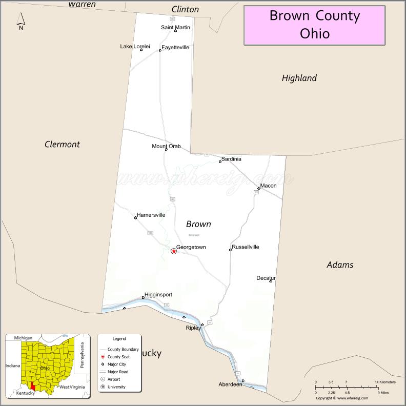
Brown County is a county in the U.S. state of Ohio. As of the 2020 United States Census, the population was 43,676. The county seat and largest city is Georgetown. The county was created in 1818 and is named for Major General Jacob Brown, an officer in the War of 1812 who was wounded at the Battle of Lundy’s Lane. Brown County is part of the Cincinnati-Middletown, OH-KY-IN Metropolitan Statistical Area.
| Name: | Brown County |
|---|---|
| FIPS code: | 39-015 |
| State: | Ohio |
| Founded: | 1 March 1818 |
| Named for: | General Jacob Brown |
| Seat: | Georgetown |
| Total Area: | 493 sq mi (1,280 km²) |
| Land Area: | 490 sq mi (1,300 km²) |
| Total Population: | 43,676 |
| Population Density: | 89/sq mi (34/km²) |
| Time zone: | UTC−5 (Eastern) |
| Summer Time Zone (DST): | UTC−4 (EDT) |
| Website: | www.browncountyohio.gov |
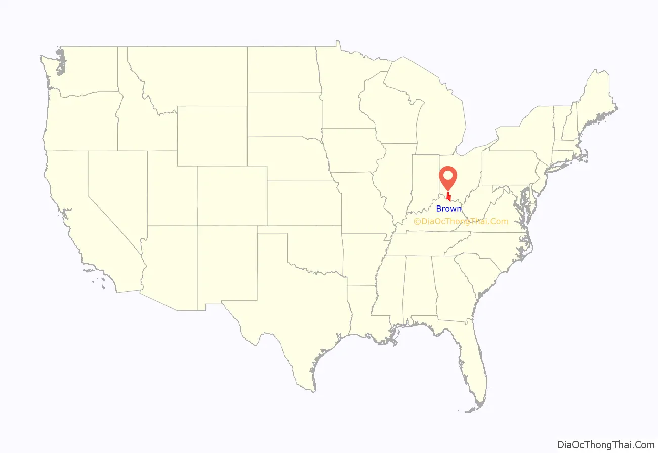
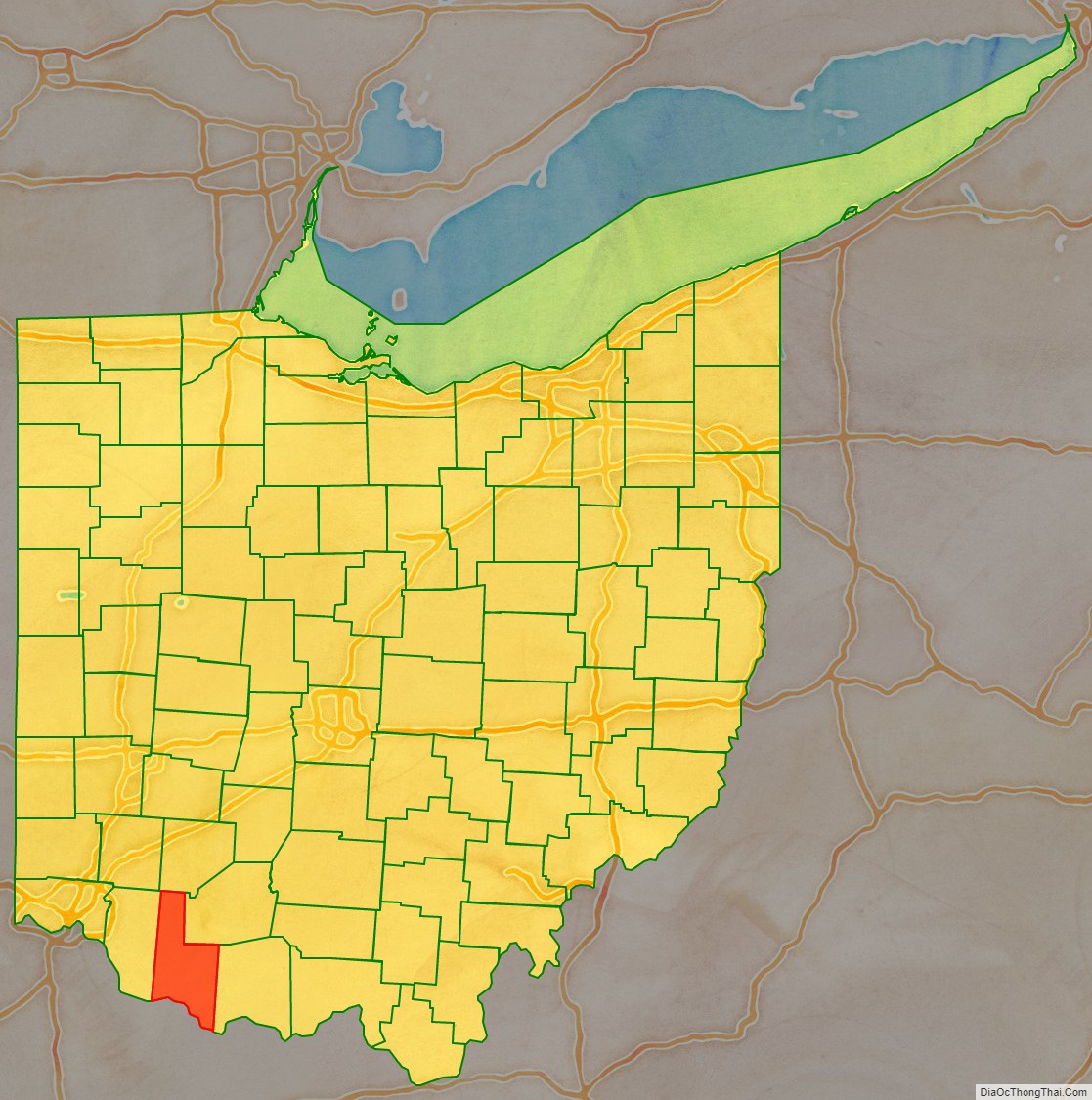
Brown County location map. Where is Brown County?
History
After the American Revolutionary War, the federal government established the Northwest Territory, a large area which encompassed the present county. In 1790 several counties were established, Hamilton among them. In 1797, a portion of Hamilton was partitioned off to create Adams County, and in 1800 another portion was partitioned to create Clermont. This lasted for two decades, during which the area north of the Ohio River attracted settlers.
Among the early settlers was Jesse Root Grant (father of future US President Grant), who built a home and set up a tannery in the future Georgetown area, where young Hiram Ulysses (later changed to Ulysses S.) spent his youth.
On 1 March 1818, portions of Adams and Clermont counties were partitioned off to create Brown County, with Georgetown as its seat. The boundaries of the county were altered in 1874, when a portion was moved to Highland County; they have remained intact since then.
Brown County was said to be the place of origin of the White Burley type of tobacco, grown in 1864 by George Webb and Joseph Fore on the farm of Captain Frederick Kautz near Higginsport, with seed from Bracken County, Kentucky. He noticed it yielded a different type of light leaf shaded from white to yellow, and cured differently. By 1866, he harvested 20,000 pounds of Burley tobacco and sold it in 1867 at the St. Louis Fair for $58 per hundred pounds. By 1883, the principal market for this tobacco was Cincinnati, but it was grown throughout central Kentucky and Middle Tennessee. Later the type became referred to as burley tobacco, and it was air-cured.
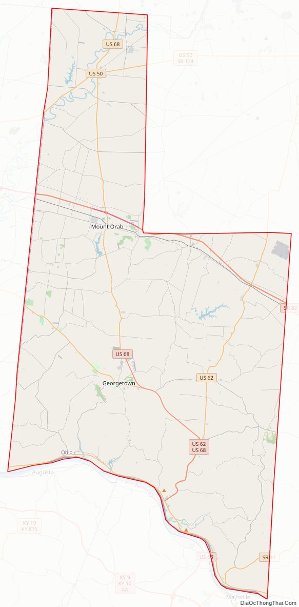
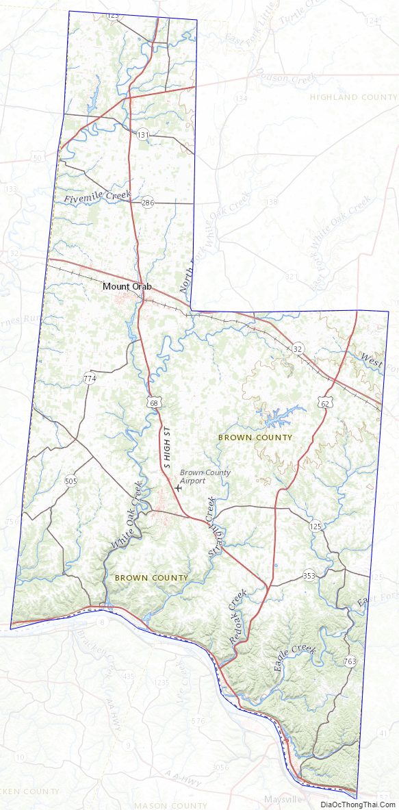
Brown County Road Map
Geography
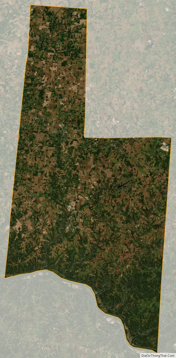
Brown County lies on the south line of the state of Ohio. Its south border abuts the north border of the state of Kentucky across the Ohio River. The Ohio flows westward along the county’s south line. White Oak Creek flows southward through the lower part of southwest Brown County, discharging into the Ohio at Higginsport; Straight Creek flows southwestward through the lower central part of the county, discharging into the Ohio two miles (3 km) east of Higginsport. Eagle Creek flows southerly through the lower eastern part of the county, discharging into the Ohio east of Ripley. The east fork of the Little Miami River flows southwestward through the upper part of the county, entering Clermont County near Marathon.
The terrain of Brown County consists of low rolling hills, carved by drainages. All available areas are devoted to agriculture. The highest point (at 1,089′ or 332 m ASL) in Brown County is a point on Ash Ridge, 9 miles (15 km) southeast of Lake Waynoka. The county has an area of 493 square miles (1,280 km), of which 490 square miles (1,300 km) is land and 3.4 square miles (8.8 km) (0.7%) is water.
Main highways
- US 50
- US 52
- US 62
- US 68
- SR 32
- SR 125
- SR 131
- SR 134
- SR 221
- SR 286
- SR 353
- SR 505
- SR 756
- SR 763
- SR 774
Adjacent counties
- Clinton County – north
- Highland County – northeast
- Adams County – east
- Mason County, Kentucky – southeast
- Bracken County, Kentucky – southwest
- Clermont County – west
Lakes
- Grant Lake
- Lake Lorelei
- Lake Waynoka
Protected areas
- Della Gates and Charles Bott Wildlife Area
- Grant Lake Wildlife Area
- Indian Creek Wildlife Area
- Eagle Creek Wildlife Area
Brown County Topographic Map
Brown County Satellite Map
Brown County Outline Map

See also
Map of Ohio State and its subdivision:- Adams
- Allen
- Ashland
- Ashtabula
- Athens
- Auglaize
- Belmont
- Brown
- Butler
- Carroll
- Champaign
- Clark
- Clermont
- Clinton
- Columbiana
- Coshocton
- Crawford
- Cuyahoga
- Darke
- Defiance
- Delaware
- Erie
- Fairfield
- Fayette
- Franklin
- Fulton
- Gallia
- Geauga
- Greene
- Guernsey
- Hamilton
- Hancock
- Hardin
- Harrison
- Henry
- Highland
- Hocking
- Holmes
- Huron
- Jackson
- Jefferson
- Knox
- Lake
- Lake Erie
- Lawrence
- Licking
- Logan
- Lorain
- Lucas
- Madison
- Mahoning
- Marion
- Medina
- Meigs
- Mercer
- Miami
- Monroe
- Montgomery
- Morgan
- Morrow
- Muskingum
- Noble
- Ottawa
- Paulding
- Perry
- Pickaway
- Pike
- Portage
- Preble
- Putnam
- Richland
- Ross
- Sandusky
- Scioto
- Seneca
- Shelby
- Stark
- Summit
- Trumbull
- Tuscarawas
- Union
- Van Wert
- Vinton
- Warren
- Washington
- Wayne
- Williams
- Wood
- Wyandot
- Alabama
- Alaska
- Arizona
- Arkansas
- California
- Colorado
- Connecticut
- Delaware
- District of Columbia
- Florida
- Georgia
- Hawaii
- Idaho
- Illinois
- Indiana
- Iowa
- Kansas
- Kentucky
- Louisiana
- Maine
- Maryland
- Massachusetts
- Michigan
- Minnesota
- Mississippi
- Missouri
- Montana
- Nebraska
- Nevada
- New Hampshire
- New Jersey
- New Mexico
- New York
- North Carolina
- North Dakota
- Ohio
- Oklahoma
- Oregon
- Pennsylvania
- Rhode Island
- South Carolina
- South Dakota
- Tennessee
- Texas
- Utah
- Vermont
- Virginia
- Washington
- West Virginia
- Wisconsin
- Wyoming