Canadian County is a county located in the U.S. state of Oklahoma. As of the 2020 census, the population was 154,405, making it the fifth most populous county in Oklahoma. Its county seat is El Reno.
The county is named for the Canadian River, which forms part of its southern border. The river may have been named for early European explorers who were fur traders and trappers from New France, or pre-1763 colonial Canada.
Canadian County is part of the Oklahoma City Metropolitan Statistical Area.
| Name: | Canadian County |
|---|---|
| FIPS code: | 40-017 |
| State: | Oklahoma |
| Founded: | March, 1890 |
| Named for: | Canadian River |
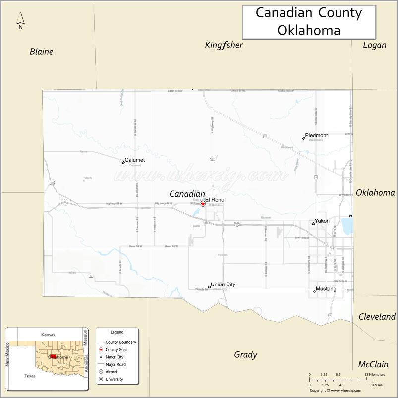
| Seat: | El Reno |
| Largest city: | Oklahoma City |
| Total Area: | 906 sq mi (2,350 km²) |
| Land Area: | 897 sq mi (2,320 km²) |
| Total Population: | 115,541 |
| Population Density: | 129/sq mi (50/km²) |
| Time zone: | UTC−6 (Central) |
| Summer Time Zone (DST): | UTC−5 (CDT) |
| Website: | www.canadiancounty.org |
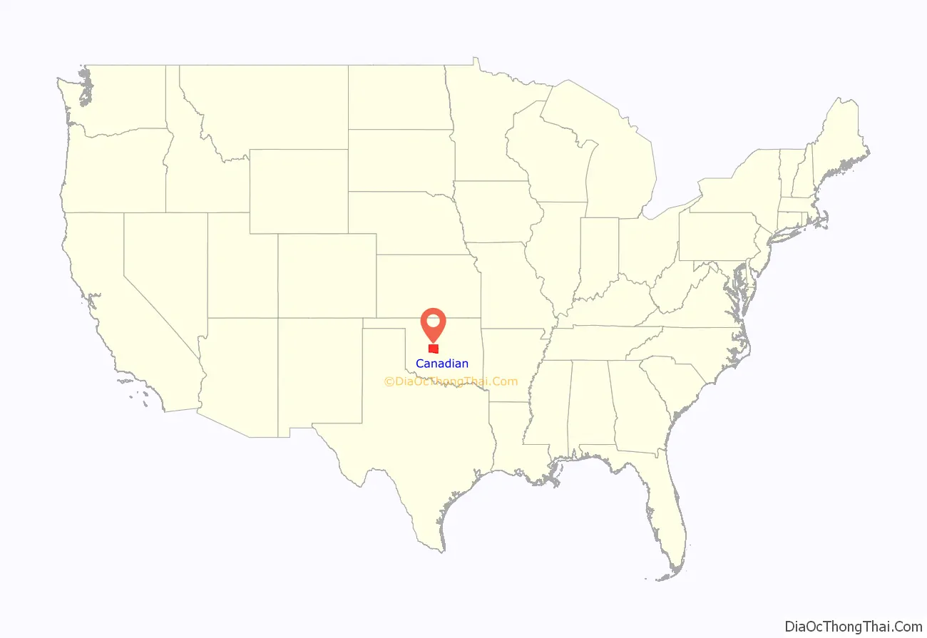
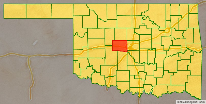
Canadian County location map. Where is Canadian County?
History
In 1859, the United States expelled the Caddo Nation of Louisiana from its Brazos reservation in Texas and relocated it to what would eventually become Canadian County, Oklahoma. Showetat, the last hereditary chief of the Caddo, set up his camp here and is considered Canadian County’s first permanent resident. (Union City developed near his camp site.)
The federal government relocated the Wichita tribe to this same part of Indian Territory in 1861. By the Treaty of Medicine Lodge, the United States assigned the land west of the Caddo and Wichita to the Cheyenne and Arapaho tribes. They were relocated from Colorado in 1869. The Cheyenne-Arapaho Agency (later renamed the Darlington Agency) was established in 1870.
Canadian County was formed in 1889 as County Four of Oklahoma Territory as part of the Oklahoma Organic Act, which created Oklahoma Territory from part of Indian Territory. It was named after the Canadian River, which runs through the county.
This county was settled by European-Americans after the April 22, 1889, land run, which gave away expropriated Native American land. It was expanded by a second land run in 1892. In 1902, after distribution of communal lands among households of the Cheyenne and Arapaho, their ‘surplus’ lands were opened to European-American settlement. El Reno was chosen as the county seat over competitors Reno City, Frisco, and Canadian City.
The county was the location of the last great battle of the Cheyenne and Arapaho against United States Army forces.
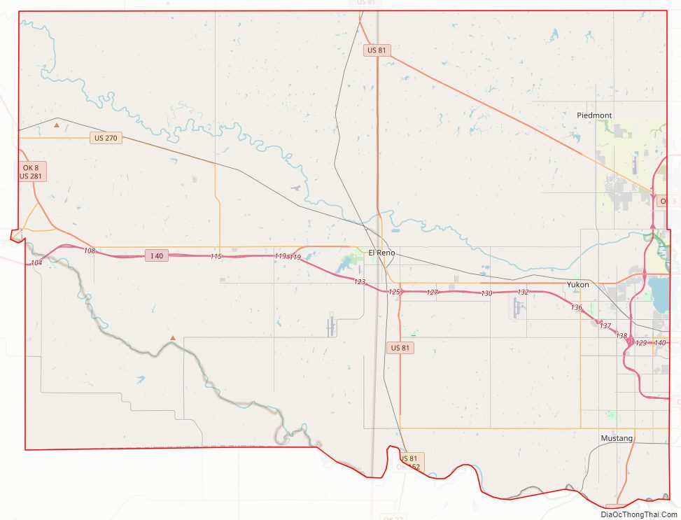
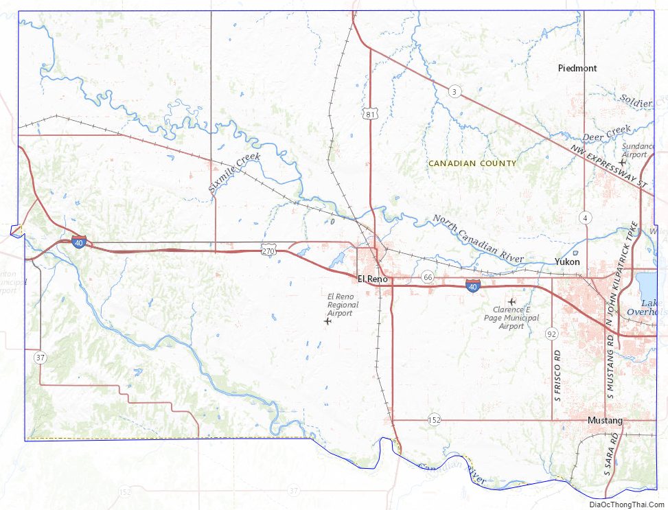
Canadian County Road Map
Geography
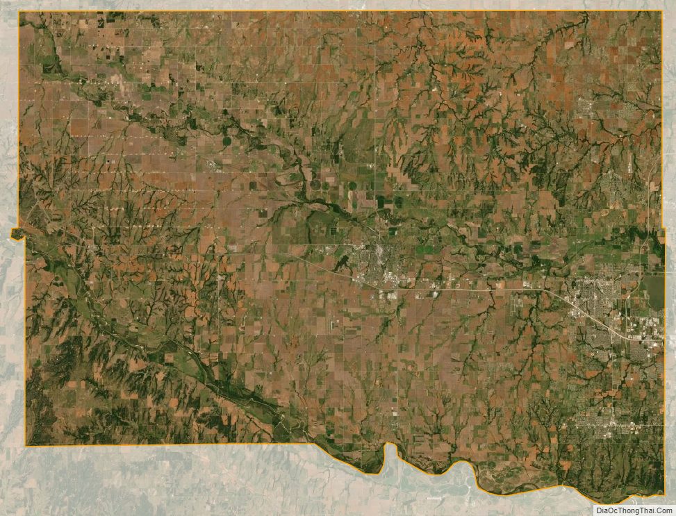
According to the U.S. Census Bureau, the county has a total area of 906 square miles (2,350 km), of which 897 square miles (2,320 km) is land and 9.0 square miles (23 km) (1.0%) is water. The county lies mostly within the Red Bed Plains, a subregion of the Osage Plains physiographic region. Its northwestern corner is in the Gypsum Hills. The county is drained by the North Canadian River and the Canadian River, which both flow through the county from northwest to southeast.
According to a study published by the Oklahoma Geological Survey, the North Canadian River drains about 40 percent of the county, the Canadian River drains about 32 percent, and the Cimarron River drains about 27 percent (mostly in the northeastern part of the county). About 1 percent of the county is drained by Sugar Creek, which empties into the Washita River, itself a tributary of the Red River.
The North Canadian River enters Canadian County near the northwest corner, flows generally southeast towards the middle of the county, then turns southward to leave the county about 8 miles (13 km) north of the southeastern corner. The river length is about 76 miles (122 km). The elevation drops from 1,420 feet (430 m) at the entry to about 1,200 feet (370 m) at the exit. Its named tributaries are Sixmile Creek, Fourmile Creek, Purcell Creek, Shell Creek, and Mustang Creek.
The Canadian River enters the western border of the county about 11 miles (18 km) north of the southwest corner at an elevation of 1,370 feet (420 m) and flows southeast about 16 miles (26 km), where it becomes the southern border of the county. Its course within the county is 45 miles (72 km) long, and the elevation where it leaves the county is 1,150 feet (350 m). Named tributaries include Dry Creek and Boggy Creek.
The Cimarron River does not flow through the county, but drains part of the northeastern area via its tributaries: Kingfisher, Dead Indian, Uncle John, Cottonwood, Soldier, and Deer creeks. The Washita River flows more than 20 miles (32 km) south of the county, but drains about 5 square miles (13 km) in the southwest corner of Canadian County.
Adjacent counties
- Kingfisher County (north)
- Logan County (northeast)
- Oklahoma County (east)
- Cleveland County (southeast)
- Grady County (south)
- Caddo County (southwest)
- Blaine County (northwest)
Canadian County Topographic Map
Canadian County Satellite Map
Canadian County Outline Map
See also
Map of Oklahoma State and its subdivision:- Adair
- Alfalfa
- Atoka
- Beaver
- Beckham
- Blaine
- Bryan
- Caddo
- Canadian
- Carter
- Cherokee
- Choctaw
- Cimarron
- Cleveland
- Coal
- Comanche
- Cotton
- Craig
- Creek
- Custer
- Delaware
- Dewey
- Ellis
- Garfield
- Garvin
- Grady
- Grant
- Greer
- Harmon
- Harper
- Haskell
- Hughes
- Jackson
- Jefferson
- Johnston
- Kay
- Kingfisher
- Kiowa
- Latimer
- Le Flore
- Lincoln
- Logan
- Love
- Major
- Marshall
- Mayes
- McClain
- McCurtain
- McIntosh
- Murray
- Muskogee
- Noble
- Nowata
- Okfuskee
- Oklahoma
- Okmulgee
- Osage
- Ottawa
- Pawnee
- Payne
- Pittsburg
- Pontotoc
- Pottawatomie
- Pushmataha
- Roger Mills
- Rogers
- Seminole
- Sequoyah
- Stephens
- Texas
- Tillman
- Tulsa
- Wagoner
- Washington
- Washita
- Woods
- Woodward
- Alabama
- Alaska
- Arizona
- Arkansas
- California
- Colorado
- Connecticut
- Delaware
- District of Columbia
- Florida
- Georgia
- Hawaii
- Idaho
- Illinois
- Indiana
- Iowa
- Kansas
- Kentucky
- Louisiana
- Maine
- Maryland
- Massachusetts
- Michigan
- Minnesota
- Mississippi
- Missouri
- Montana
- Nebraska
- Nevada
- New Hampshire
- New Jersey
- New Mexico
- New York
- North Carolina
- North Dakota
- Ohio
- Oklahoma
- Oregon
- Pennsylvania
- Rhode Island
- South Carolina
- South Dakota
- Tennessee
- Texas
- Utah
- Vermont
- Virginia
- Washington
- West Virginia
- Wisconsin
- Wyoming