Carter County is a county in the Ozarks of Missouri. At the 2020 census, it had a population of 5,202. The largest city and county seat is Van Buren. The county was officially organized on March 10, 1859, and is named after Zimri A. Carter, a pioneer settler who came to Missouri from South Carolina in 1812.
| Name: | Carter County |
|---|---|
| FIPS code: | 29-035 |
| State: | Missouri |
| Founded: | March 10, 1859 |
| Named for: | Zimri A. Carter, a pioneer settler who came to Missouri from South Carolina in 1812 |
| Seat: | Van Buren |
| Largest city: | Van Buren |
| Total Area: | 509 sq mi (1,320 km²) |
| Land Area: | 507 sq mi (1,310 km²) |
| Total Population: | 5,202 |
| Population Density: | 10/sq mi (3.9/km²) |
| Time zone: | UTC−6 (Central) |
| Summer Time Zone (DST): | UTC−5 (CDT) |
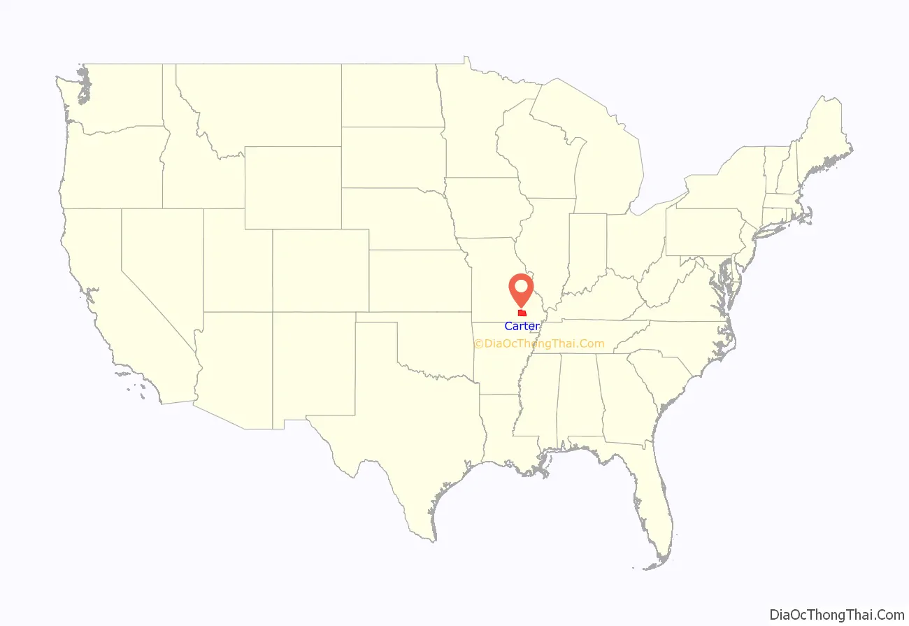
Carter County location map. Where is Carter County?
History
Creation
When the Missouri legislature created Carter County on March 10, 1859, it named the county after Zimri A. Carter.
Zimri A. Carter (1794–1872) was born in South Carolina. In 1807, at the age of 13, he came to Missouri with his parents. The Carter family initially settled in what is now Warren County. Shortly after his arrival in Missouri Carter joined up with a party of traders traveling the Missouri and Mississippi rivers in flat boats, and was away for a number of years. In his absence his father Benjamin Carter traded a horse and a cow for a large tract of land in what was then Wayne County, about eight miles southeast of where the town of Van Buren would eventually be established. When Carter returned from his trading ventures he joined his father in farming their new homestead. (Various sources give dates as early as 1812 and as late as 1820 for Zimri Carter’s arrival in the area.) Carter became one of the most influential and respected men in southeast Missouri and was instrumental in bringing about the creation of Carter County and served for a time as county judge of Carter County. The Carters were soon followed by other families: the Chilton, Kenard, Snider and Kelly families, who, along with the Carters opened up large tracts of wilderness land.
Carter County was created from portions of Ripley, Shannon and Wayne counties. On the first Monday of April 1859, three men (Adam Lane of Ripley County, John Bulford of Reynolds County and D.C. Reed of Shannon County) met at the home of James Brown to select a seat for the newly created Carter County. They selected Van Buren which, until 1847, had been the county seat of Ripley County. At the time of its creation, Carter County was attached to Ripley County for the purpose of representation in the General Assembly. The old log-cabin courthouse, which had been erected in Van Buren in 1853, continued to be used as the Carter County Courthouse until it was replaced by a wood-frame building in 1867.
William Lawson was the first person elected to the Missouri legislature from Carter County in 1864 and served until 1870, at which time he was succeeded by F.M. Coleman.
Initially Carter County had only one voting precinct, and all voting was done at the county courthouse in Van Buren. In June 1868 the court ordered that Carter County be divided into two precincts, with Precinct #1 consisting of the western half of the county where voting was done in the courthouse, and Precinct #2 in the eastern half with voting taking place at the home of John Carnahan on the head of the middle fork of Brushy Creek. By 1895, at the height of the timber boom, Carter County had as many as ten precincts.
The 1860 U.S. Census showed the newly created Carter County with a population of 1,197 free persons and 20 slaves held by eight slave owners. The 1920 U.S. Census showed a peak population for Carter County of 7,482. The population then declined until it reached a low of 3,878 in the 1970 U.S. Census. The population has since risen steadily. As of the 2010 U.S. Census, the county’s population was 6,265.
Civil War
The U.S. Civil War began about two years after Carter County was established. At the time most of the people in Carter County were southern sympathizers and supporters of the Confederate States of America. The Union Army of Southeast Missouri was encamped in the area during the winter of 1862–63, and Carter County saw a number of local skirmishes, but by the war’s end it had suffered only minimal property damage.
On August 12, 1862, the 24th Missouri Infantry (Union) under the command of Colonel Boyd surprised six rebel soldiers near Van Buren. In the ensuing skirmish two of the rebel soldiers were killed and another three captured. In the course of events one mill and three houses were burned. Also taken was a packet of rebel mail that was being sent from the camp of Confederate general James McBride to Potosi, Missouri, telling of his plans to take Greenville.
In September 1862 Rebel forces under the command of Colonel David C. Boone, who had been in Southeast Missouri recruiting troops for the Confederacy, was driven from Reynolds County into Carter County by elements of the 12th Cavalry MSM. About a month later, the Union authorities finally discovered the location of Colonel David C. Boone’s forces in Carter County. Lieutenant Colonel Bazel F. Lazear was sent into Carter County with forces of the 12th Cavalry MSN to drive them out. During the evening of October 22, 1862, Lt. Colonel Bazel F. Lazear’s forces surprised the estimated 450 well armed Confederate troops under the command of Colonel David C. Boone, driving them through the town of Van Buren. On October 25, 1862, Boone’s forces were once again discovered, this time near Pike Creek in western Carter County. Attacking the Rebel forces from a nearby hill, the Union forces killed eight and captured 16 of the Rebels. Altogether, the Union forces under Colonel Bazel F. Lazear captured a total of 40 Rebel troops on this expedition, who were subsequently sent to military prisons in St. Louis. The total Union loss was only one man.
From December 1862 to January 1863 Union General John W Davidson, en route to the south with a force of about 3000 troops, camped near Van Buren. At the same time, coming from the south and moving north were a number of Confederate troops under the command of General Jeff Thompson, who had, unknown to the Union forces, camped not far away on top of Barren Hill. Discovering the presence of the Union forces the next day they surprised a company of Union troops as they were loading supplies they had purchased from local farms. After a battle that lasted about an hour the Union forces were forced to retreat, leaving their wagons and supplies behind. One Confederate soldier was killed and about twenty-five wounded. After treating their wounded and loading them into the wagons, the southern forces retreated westward toward Pike Creek that afternoon. General Davidson then sent out a force of about 400 men in an effort to capture General Thompson, but they were unable to find him. Two Union soldiers died of their wound in this battle.
By far, most of the death and destruction in Carter County did not come at the hand of either Union or Confederate troops, but from bands of outlaws known as Jayhawkers and Bushwhackers respectively depending on whether they sympathized with the north of the south. Many of these outlaw bands were composed of native Carter County residents who were taking advantage of the war to settle personal grudges. Thomas Gardner, the first elected sheriff of Carter County was killed by one of these native outlaw bands.
One local history describes a short lived community of freed slaves that arose about two miles south of Van Buren after the Civil War. Because of its location near the Carter Homestead this community came to be known as Carterville. This community included not only freed slaves from Carter County but also many from surrounding regions. Their first winter was one of suffering, and disease killed many of them. Their graveyard is located in a little field at the mouth of Water Hollow about one and a half mile below Van Buren on the banks of the Current River.
Timber industry
The Missouri Lumber and Mining Company, more than any other entity was for many years to shape the economic, cultural, and ecologic landscape of Carter County.
The Missouri Lumber and Mining Company moved into Carter County in 1887 and made it for many years the primary lumber production center of Missouri. Shipping a sawmill by rail to Williamsville, which at the time was the end of the line, it was then hauled by wagons into Carter County, to a site that was selected because of a large natural pond known as Tolliver Pond. There on land that was originally patented by William A Simms in 1857 the Missouri Lumber and Mining Company in 1887 laid out and founded the town of Grandin, naming it for the principle stockholder in the company.
The Missouri Lumber and Mining Company also brought the railroad into Carter County when in 1887 they granted the Current River branch of the Frisco Railroad a right-of-way across their land. The rail line to Grandin was finished two years later in 1889, and the first regular train service to the new born town of Grandin ran on July 3 that same year.
In order to feed the giant sawmill it had established in Carter County, which required logs from 70 acres of land each day to keep it running, the Missouri Lumber and Mining Company laid down miles of narrow gauge railroads that radiated outward beyond Carter County and into neighboring Reynolds, Wayne, Butler, Ripley and Shannon counties. At its peak the sawmills in Carter County produced in excess of 60 to 70 million board feet of lumber each year.
In 1900 the timber boom in Carter County was in full stride.
By 1909 much of the virgin pine forest in and around Carter County had been cut down.
In 1910 the lumber boom ended when the Grandin mill whistle blew for the last time.
By 1911 all the equipment had been moved to the new mill at West Eminence in Shannon County, leaving behind an economically and ecologically devastated landscape.
Mid-Continent Iron Company
In 1917 Frank Larabee, E. H. Busick and others came to Carter County and formed the Mid-Continent Iron Company. After purchasing property about two miles north of Fremont they established a smelter with the intention of producing pig iron from ore shipped from Michigan. By November 1918 the plant was ready for production.
A town named Midco, after the Mid-Continent Iron Company, arose as people moved into the area first to build the smelter and afterward to work at the plant. At its peak in 1920 the town had in excess of 3000 inhabitants, which was about half of the entire population of Carter County at the time.
Like the Missouri Lumber and Mining Company before it, the Mid-Continent Iron Company built its own railroad system to transport the wood needed to fire the blast furnace. While the Missouri Lumber and Mining Company harvested the virgin pine forests, the Mid-Continent Iron Company harvested the hardwoods from which to make the charcoal they needed to operate their blast furnace. Typically 180 cords of wood a day was converted into charcoal to operate the furnace. The company had two small and five larger locomotives running on their railroad system to haul the wood to their plant.
At the outbreak of World War I the U. S. government demanded that a modern chemical plant be installed at Midco. They wanted the byproducts coming from the wood as it was being converted to charcoal, byproducts such as wood alcohol, tar, calcium acetate and other wood oils. Thus in addition to the iron works, Midco became the site of a sprawling chemical plant.
The global flu pandemic of 1918-1920 hit the community of Midco in some cases wiping out whole families. At its peak there were two crews digging graves day and night. Of the 100-200 victims of the flu buried in the Midco Cemetery only 6 have tombstones.
With the end of World War I there was no longer any demand for the products the company was producing and so in 1921 the Mid-Continent Iron Company closed. With the closing of the plant the people moved away and by 1930 Midco was nearly a ghost town. Today little remains to show that what was once the largest community in Carter County even existed.
Post boom years
With the loss of the big sawmills of the Missouri Lumber and Mining Company, and the closing of the Mid-Continent Iron Company, the population of Carter County began a decline that did not reverse until about 1970. Many communities, both large and small, that had sprung up in Carter County during the boom years of the lumber industry disappeared. Grandin itself survived but with scarcely a tenth of its former population.
Those who remained behind when the big mills left were forced to eke out a living trying to grow a few crops on the rocky, barren, eroded hills. Free-ranging cattle were left to roam the woods, foraging on acorns and sprouts.
To make matters worse, it was a common practice to burn the wooded areas in the mistaken belief that the fire would kill ticks and make grass grow. Paul Dunn, a District Forester who worked in the area in the 1920s and 1930s once reported that at least 75 percent of the land outside of state parks were burned off twice a year.
By 1938, Grandin’s population had fallen to 300, a tenth of its 1900 population, and the Frisco Railroad gave notice that it would be discontinuing its service to Grandin. However that same year news was also received that a new state highway would be routed through Carter County, passing through the town of Grandin.
Conservation and reforestation
In 1910, John Barber White, who was one of the principles of the Missouri Lumber and Mining Company, took Gifford Pinchot of the U.S. Forest Service on a tour of the over cut forests and urged him, in the interest of conservation, to establish a national forest in the Missouri Ozarks. But it was not until 1933 that the Mark Twain National Forest, which includes parts of Carter County, was established.
In 1928 the Missouri General Assembly authorized the creation of a Department of Forestry to which Fredrick Dunlap was appointed as State forester, and Paul Dunn made a District Forester in for the region including Carter County. Paul Dunn in an effort to educate the people in the Carter and the surrounding counties in proper forest management took a single film titled “Trees of Righteousness,” and with his Model-T, a movie projector and a generator went from school district to school district, showing the film, and wearing out five copies of it in the process.
But the situation was so bad that in 1931 State Forester Fredrick Dunlap declared that stopping the forest fires in the Ozarks was an impossibility, and the Governor vetoed funding and abolished the Forestry Department. By the mid-1930s the ecological devastation left behind by the timber boom reached its all-time low. The forests were burned, sediment eroding from once forested hillsides choked once clear streams. It was estimated that only 2000 deer and a few scattered flocks of turkeys remained in the entire state.
In 1936 Missouri voters approved the creation of a Conservation Commission which included a forestry department. In 1938 George O. White was made State Forester and following in the footsteps of Paul Dunn he took a truck equipped with a movie projector, screen and generator and showed forestry movies throughout the Ozark hill county. And for 12 years these movies were shown wherever an audience was to be found, indoors and outdoors, in schools and churches and stores. And the effort paid off. Attitudes and practices toward land management began to change, the fires stopped, the forests grew back, and deer and turkey are back in record numbers. Where once 75 percent of the land was burned off twice each year, now less than one tenth of one percent burns each year. Once-devastated forests can again be classified as wilderness areas and the timber industry once again flourishes in Carter County.
The 1920s through the 1970s
The 1920s saw the creation of Big Spring State Park, but more importantly for the county the 1920s also saw the construction of the Cross-State Highway (now U.S. Route 60) and the construction of a permanent bridge across the Current River at Van Buren. The creation of the highway and the state park marked the beginnings of a tourist industry with Smalley’s Tourist Camp and the Rose Cliff Hotel serving tourists in the Van Buren area for many years.
The 1930s saw the construction of highway 103 from Van Buren to Big Spring, making access to the state park much easier. That decade also saw the construction of the Jefferson Highway (now State Route 21) in the eastern half of Carter County and which served the towns of Grandin, Hunter, and Ellsinore.
The population of the county continued to drop throughout the 1920s and 1930s simply because there were very few jobs to be had. During the depression years, in an attempt to fight the loss of jobs as many as five Civil Conservation Corps camps were established in the county. Three of these were located in west Carter County near Van Buren and a fourth near Fremont. The fifth was located in east Carter County near Ellsinore.
With the nation’s entry into World War II in 1941, the county’s population continued to fall as there was a much better chance of finding employment elsewhere. The 1940s also saw the election of a native Carter County resident to the U. S. Congress when A. S. J. Carnahan was elected to the U.S. House of Representatives.
The 1950s saw the town of Fremont devastated by an F4 tornado that was part of the May 1957 Central Plains tornado outbreak. This decade also saw talk of damming the Current River, something that the locals were against. With the closing of the 1950s, Carter County celebrated its centennial.
In 1964 congress authorized the creation of the Ozark National Scenic Riverways and in 1972 Current River became a part of that Riverways system, giving a great boost the Carter County’s tourism industry. From the 1970s onward the population of Carter County has steadily increased.
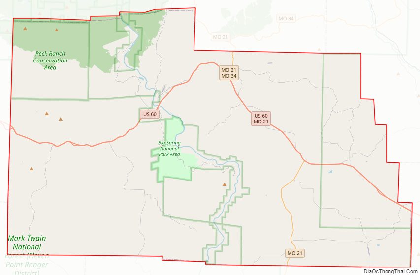
Carter County Road Map

Geography
According to the U.S. Census Bureau, the county has a total area of 509 square miles (1,320 km), of which 507 square miles (1,310 km) is land and 1.7 square miles (4.4 km) (0.3%) is water.
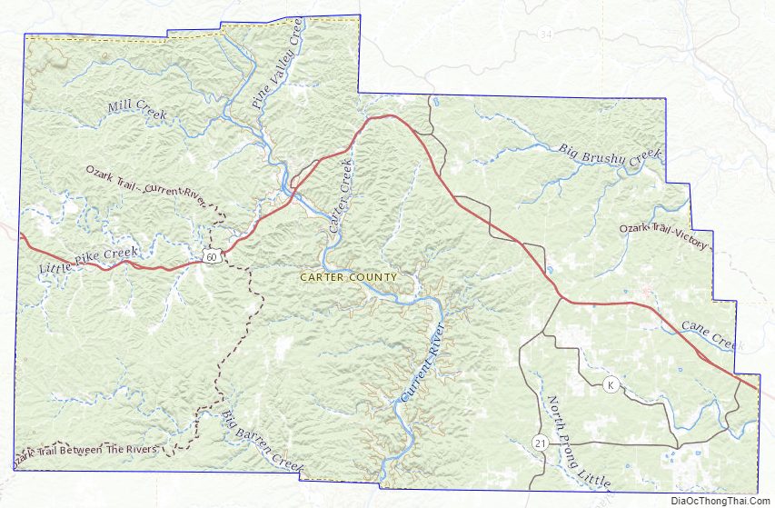
Carter County is in the rugged southern Courtois Hills region of the southeastern Ozark Plateau, and is roughly dissected from north to south by the Current River. Much of the county consists of wooded hills and valleys, with the landscape becoming more rolling and the hills having broader tops and gentler slopes in the southeastern portions of the county. The topography of Carter County is essentially that of a highly dissected plateau.
The western and central sections of the county are drained by the Current River and its tributaries: Rogers Creek, Mill Creek, Pike Creek, Big Barren Creek, Aldridge Valley, Hen Peck Creek and Carters Creek. The eastern section of the county is drained by Cane Creek, Beaver Dam Creek, Little Black and Big Brushy Creek, all of which are tributaries of the Black River.
Stegall Mountain, with an elevation of 1,348 feet, is the highest point in the county. The county’s lowest elevations, about 400 feet, may be found in the river valleys on its southern boundary.
The bedrock is mostly (92.3%) Ordovician in age, with 7% being Cambrian and the remainder Precambrian. The weathering of this bedrock has produced an extensive system of solution channels and caves. This has resulted in the creation of numerous springs, with the largest being Big Spring located in the Current River near Van Buren. Some of the larger caves to be found in Carter County are Camp Yarn Cave, Midco Cave, Granite Quarry Cave, and Lost Man’s Cave.
Carter County has numerous small deposits of brown iron ore (limonite), and some effort has been made in the past to mine them, but the efforts have generally not been cost effective. The most notable limonite mining effort was at the Orchard Mine near Ellsinore. This mine operated for a ten-year period between 1902 and 1912, and for a time Carter County ranked 16th in the State of Missouri in iron ore production.
The principle geologic formations in Carter County, ranked in order of surface exposure, are:
- Roubidoux (52%), Ordovician
- Gasconade (40%), Ordovician
- Eminence and Potosi (7%), Cambrian
- St. Francois Mountains Volcanic Supergroup (0.5%), Precambrian
- Smithville, Powell, Cotter and Jefferson City dolomites (0.3%), Ordovician
- St Francois Mt. Intrusive Suite (0.1%), Precambrian
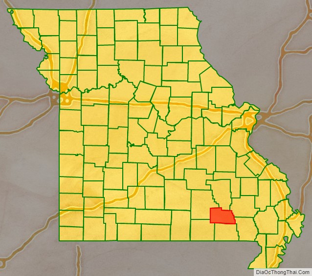
Adjacent counties
- Reynolds County (north)
- Wayne County (northeast)
- Butler County (southeast)
- Ripley County (south)
- Oregon County (southwest)
- Shannon County (west)
Major highways
- U.S. Route 60
Built mid-1920s. Formerly known as the Cross-State Highway, later as Route 16.
- Route 21
Built early 1930s. Formerly known as the Jefferson Highway.
- Route 34
National protected areas
- Mark Twain National Forest (part)
- Ozark National Scenic Riverways (part)
Carter County Topographic Map
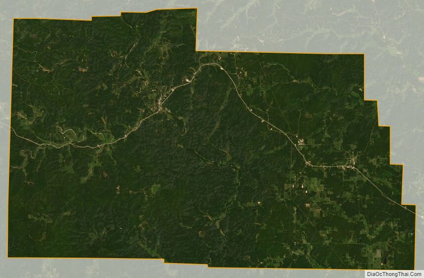
Carter County Satellite Map
Carter County Outline Map

See also
Map of Missouri State and its subdivision:- Adair
- Andrew
- Atchison
- Audrain
- Barry
- Barton
- Bates
- Benton
- Bollinger
- Boone
- Buchanan
- Butler
- Caldwell
- Callaway
- Camden
- Cape Girardeau
- Carroll
- Carter
- Cass
- Cedar
- Chariton
- Christian
- Clark
- Clay
- Clinton
- Cole
- Cooper
- Crawford
- Dade
- Dallas
- Daviess
- De Kalb
- Dent
- Douglas
- Dunklin
- Franklin
- Gasconade
- Gentry
- Greene
- Grundy
- Harrison
- Henry
- Hickory
- Holt
- Howard
- Howell
- Iron
- Jackson
- Jasper
- Jefferson
- Johnson
- Knox
- Laclede
- Lafayette
- Lawrence
- Lewis
- Lincoln
- Linn
- Livingston
- Macon
- Madison
- Maries
- Marion
- McDonald
- Mercer
- Miller
- Mississippi
- Moniteau
- Monroe
- Montgomery
- Morgan
- New Madrid
- Newton
- Nodaway
- Oregon
- Osage
- Ozark
- Pemiscot
- Perry
- Pettis
- Phelps
- Pike
- Platte
- Polk
- Pulaski
- Putnam
- Ralls
- Randolph
- Ray
- Reynolds
- Ripley
- Saint Charles
- Saint Clair
- Saint Francois
- Saint Louis
- Sainte Genevieve
- Saline
- Schuyler
- Scotland
- Scott
- Shannon
- Shelby
- Stoddard
- Stone
- Sullivan
- Taney
- Texas
- Vernon
- Warren
- Washington
- Wayne
- Webster
- Worth
- Wright
- Alabama
- Alaska
- Arizona
- Arkansas
- California
- Colorado
- Connecticut
- Delaware
- District of Columbia
- Florida
- Georgia
- Hawaii
- Idaho
- Illinois
- Indiana
- Iowa
- Kansas
- Kentucky
- Louisiana
- Maine
- Maryland
- Massachusetts
- Michigan
- Minnesota
- Mississippi
- Missouri
- Montana
- Nebraska
- Nevada
- New Hampshire
- New Jersey
- New Mexico
- New York
- North Carolina
- North Dakota
- Ohio
- Oklahoma
- Oregon
- Pennsylvania
- Rhode Island
- South Carolina
- South Dakota
- Tennessee
- Texas
- Utah
- Vermont
- Virginia
- Washington
- West Virginia
- Wisconsin
- Wyoming