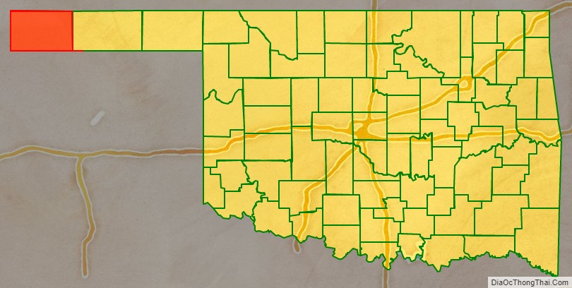
Cimarron County is the westernmost county in the U.S. state of Oklahoma. Its county seat is Boise City. As of the 2020 census, its population was 2,296, making it the least-populous county in Oklahoma; and indeed, throughout most of its history, it has had both the smallest population and the lowest population density of any county in Oklahoma. Located in the Oklahoma Panhandle, Cimarron County contains the only community in the state (Kenton) that observes the Mountain Time Zone. Black Mesa, the highest point in the state, is in the northwest corner of the county. The Cimarron County community of Regnier has the distinction of being the driest spot in Oklahoma ranked by lowest annual average precipitation, at just 15.62 inches; but at the same time, Boise City is the snowiest location in Oklahoma ranked by highest annual average snowfall, at 31.6 inches.
| Name: | Cimarron County |
|---|---|
| FIPS code: | 40-025 |
| State: | Oklahoma |
| Founded: | 1907 |
| Seat: | Boise City |
| Largest city: | Boise City |
| Total Area: | 1,841 sq mi (4,770 km²) |
| Land Area: | 1,835 sq mi (4,750 km²) |
| Total Population: | 2,296 |
| Population Density: | 1.2/sq mi (0.5/km²) |
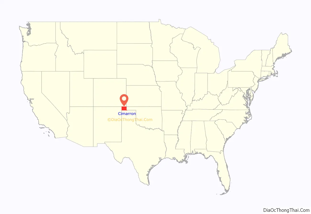
Cimarron County location map. Where is Cimarron County?
History
Cimarron County was created at statehood in 1907. Before the Oklahoma Organic Act was passed in 1890, the area had belonged to what was known as “No-Man’s Land”, also referred to as the “Public Land Strip”. This was a relatively lawless area, with no organized government, and several outlaws sought refuge within its borders. In 1890, the strip became known as Beaver County, Oklahoma Territory. Informally, it was known as the “Oklahoma Panhandle”. Only two communities were in the strip. One, Carrizo (near present-day Kenton), had 83 residents in 1890, while the other, Mineral City, had 93 residents. Otherwise, the land was used primarily by sheepherders from New Mexico.
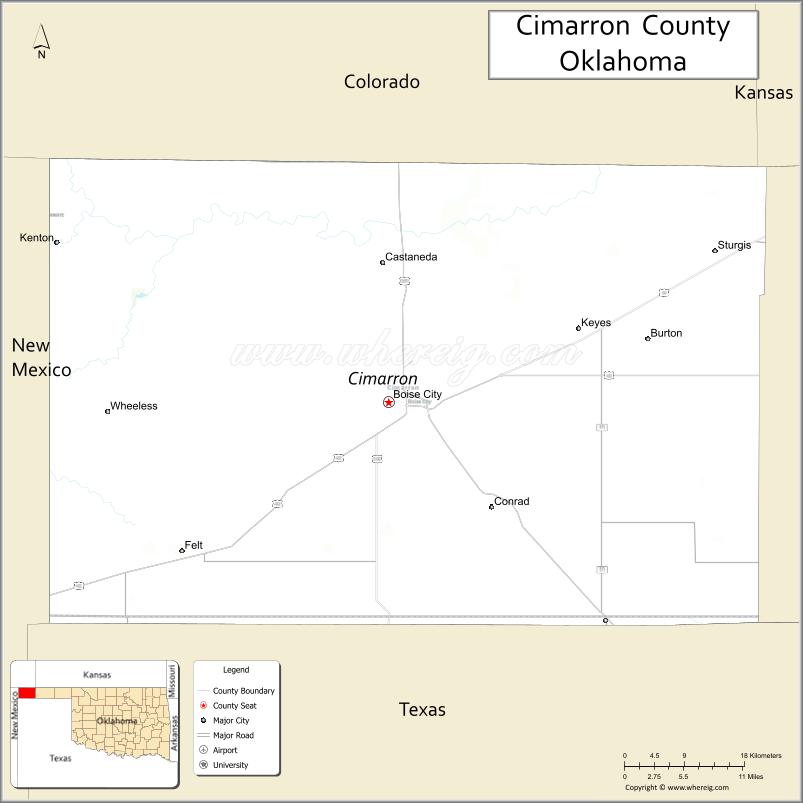
Several communities vied to become county seat after statehood: Boise City, Cimarron, Doby, Hurley, Willowbar, and Centerview. A county election in 1908 selected Boise City.
Railroads came late to this part of Oklahoma. The Elkhart and Santa Fe Railway built a line from Elkhart, Kansas, through Cimarron County in 1925. It completed the link into New Mexico in 1932. Service ended in 1942. The same company built a line from Colorado to Boise City in 1931 and extended it into Texas in 1937. This line still operates and in 2000 was part of the BNSF system.
Cimarron County was affected by the Dust Bowl and was the site of the iconic 1936 photo entitled Dust Bowl Cimarron County, Oklahoma.
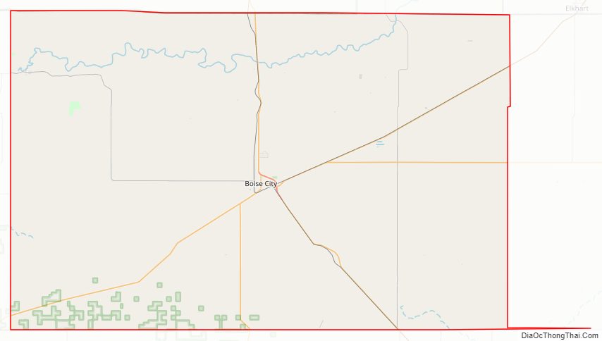
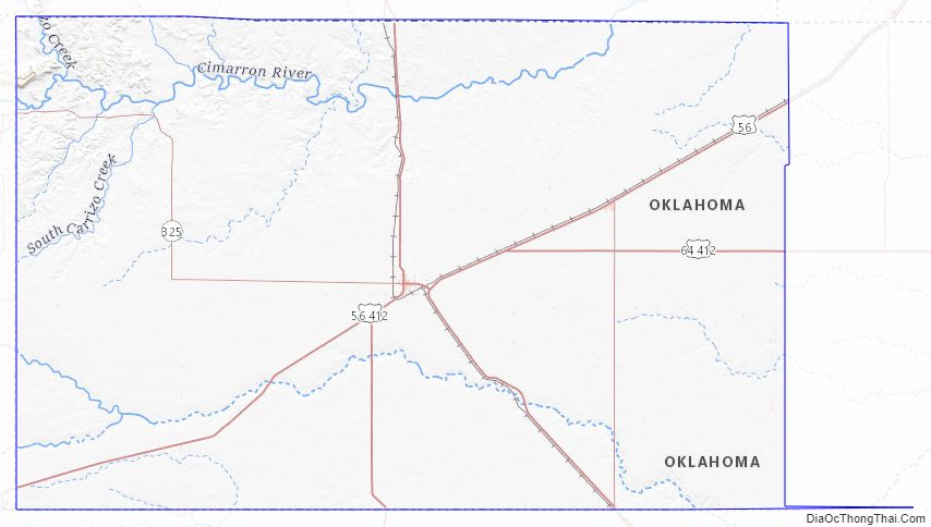
Cimarron County Road Map
Geography
According to the U.S. Census Bureau, the county has a total area of 1,841 square miles (4,770 km), of which 1,835 square miles (4,750 km) are land and 6.1 square miles (16 km) (0.3%) are covered by water. It is the fourth-largest county in Oklahoma by area. It also has Oklahoma’s highest point at 4,973 feet (1,516 m) above mean sea level on the Black Mesa.
The northern part of the county is drained by the Cimarron River, which flows eastward, then turns north into Kansas. The southern part is drained by the Beaver River (sometimes also called the North Canadian River). The man-made Lake Carl Etling lies inside Black Mesa Park.
The Boise City Airport (FAA ID: 17K) is about 3 miles north of town.
Major highways
- U.S. Highway 56
- U.S. Highway 64
- U.S. Highway 287
- U.S. Highway 385
- U.S. Highway 412
- State Highway 3
- State Highway 171
- State Highway 325
Adjacent states and counties
Cimarron County is the only county in the United States that borders four states: Colorado, Kansas, New Mexico, and Texas. As a result, Cimarron County is the only county in the United States to border at least five counties from five different states (one from each of the four aforementioned states, plus one in Oklahoma and a second county in Texas).
- Baca County, Colorado (north/Mountain Time border)
- Morton County, Kansas (northeast)
- Texas County (east)
- Dallam County, Texas (south)
- Sherman County, Texas (southeast)
- Union County, New Mexico (west/Mountain Time border)
A location 300 yards (270 m) east of US 287-385 and 1.75 miles (2.82 km) south of the Cimarron River is the only place in the US less than 27 miles (43 km) from five different states: 26.99 miles (43.44 km) from Kansas, New Mexico, and Texas and 7 miles (11 km) from Colorado.
National protected area
- Rita Blanca National Grassland (part)
Images
Black Mesa, the highest point in Oklahoma, is in the northwestern corner of Cimarron County.
U.S. Route 412 in Cimarron County.
Farmer and two sons during a dust storm in Cimarron County, April 1936
Area affected by the Dust Bowl between 1935 and 1938.
NASA satellite image of Cimarron County, August 2008.
Cimarron County Topographic Map
Cimarron County Satellite Map
Cimarron County Outline Map

See also
Map of Oklahoma State and its subdivision:- Adair
- Alfalfa
- Atoka
- Beaver
- Beckham
- Blaine
- Bryan
- Caddo
- Canadian
- Carter
- Cherokee
- Choctaw
- Cimarron
- Cleveland
- Coal
- Comanche
- Cotton
- Craig
- Creek
- Custer
- Delaware
- Dewey
- Ellis
- Garfield
- Garvin
- Grady
- Grant
- Greer
- Harmon
- Harper
- Haskell
- Hughes
- Jackson
- Jefferson
- Johnston
- Kay
- Kingfisher
- Kiowa
- Latimer
- Le Flore
- Lincoln
- Logan
- Love
- Major
- Marshall
- Mayes
- McClain
- McCurtain
- McIntosh
- Murray
- Muskogee
- Noble
- Nowata
- Okfuskee
- Oklahoma
- Okmulgee
- Osage
- Ottawa
- Pawnee
- Payne
- Pittsburg
- Pontotoc
- Pottawatomie
- Pushmataha
- Roger Mills
- Rogers
- Seminole
- Sequoyah
- Stephens
- Texas
- Tillman
- Tulsa
- Wagoner
- Washington
- Washita
- Woods
- Woodward
- Alabama
- Alaska
- Arizona
- Arkansas
- California
- Colorado
- Connecticut
- Delaware
- District of Columbia
- Florida
- Georgia
- Hawaii
- Idaho
- Illinois
- Indiana
- Iowa
- Kansas
- Kentucky
- Louisiana
- Maine
- Maryland
- Massachusetts
- Michigan
- Minnesota
- Mississippi
- Missouri
- Montana
- Nebraska
- Nevada
- New Hampshire
- New Jersey
- New Mexico
- New York
- North Carolina
- North Dakota
- Ohio
- Oklahoma
- Oregon
- Pennsylvania
- Rhode Island
- South Carolina
- South Dakota
- Tennessee
- Texas
- Utah
- Vermont
- Virginia
- Washington
- West Virginia
- Wisconsin
- Wyoming