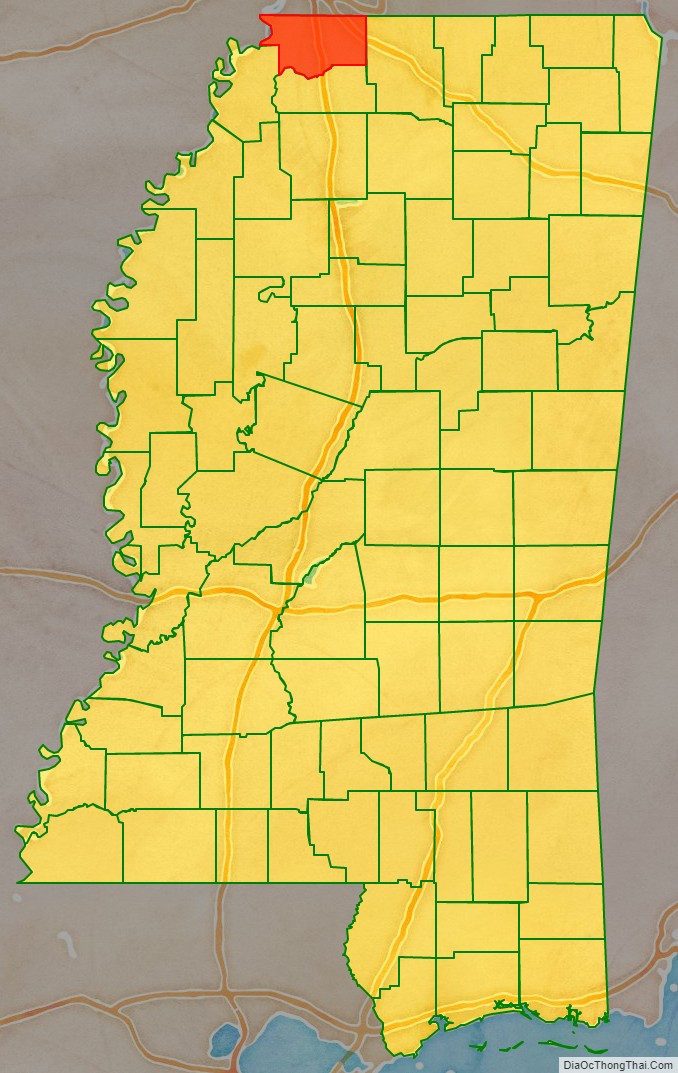
DeSoto County is a county located on the northwestern border of the U.S. state of Mississippi. As of the 2020 census, the population was 185,314, making it the third-most populous county in Mississippi. Its county seat is Hernando.
DeSoto County is part of the Memphis, TN-MS-AR Metropolitan Statistical Area. It is the second-most populous county in the MSA. The county has lowland areas that were developed in the 19th century for cotton plantations, and hill country in the eastern part of the county.
| Name: | Desoto County |
|---|---|
| FIPS code: | 28-033 |
| State: | Mississippi |
| Founded: | February 9, 1836 |
| Named for: | Hernando de Soto |
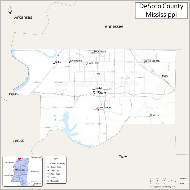
| Seat: | Hernando |
| Largest city: | Southaven |
| Total Area: | 497 sq mi (1,290 km²) |
| Land Area: | 476 sq mi (1,230 km²) |
| Total Population: | 185,314 |
| Population Density: | 370/sq mi (140/km²) |
| Time zone: | UTC−6 (Central) |
| Summer Time Zone (DST): | UTC−5 (CDT) |
| Website: | www.desotocountyms.gov |
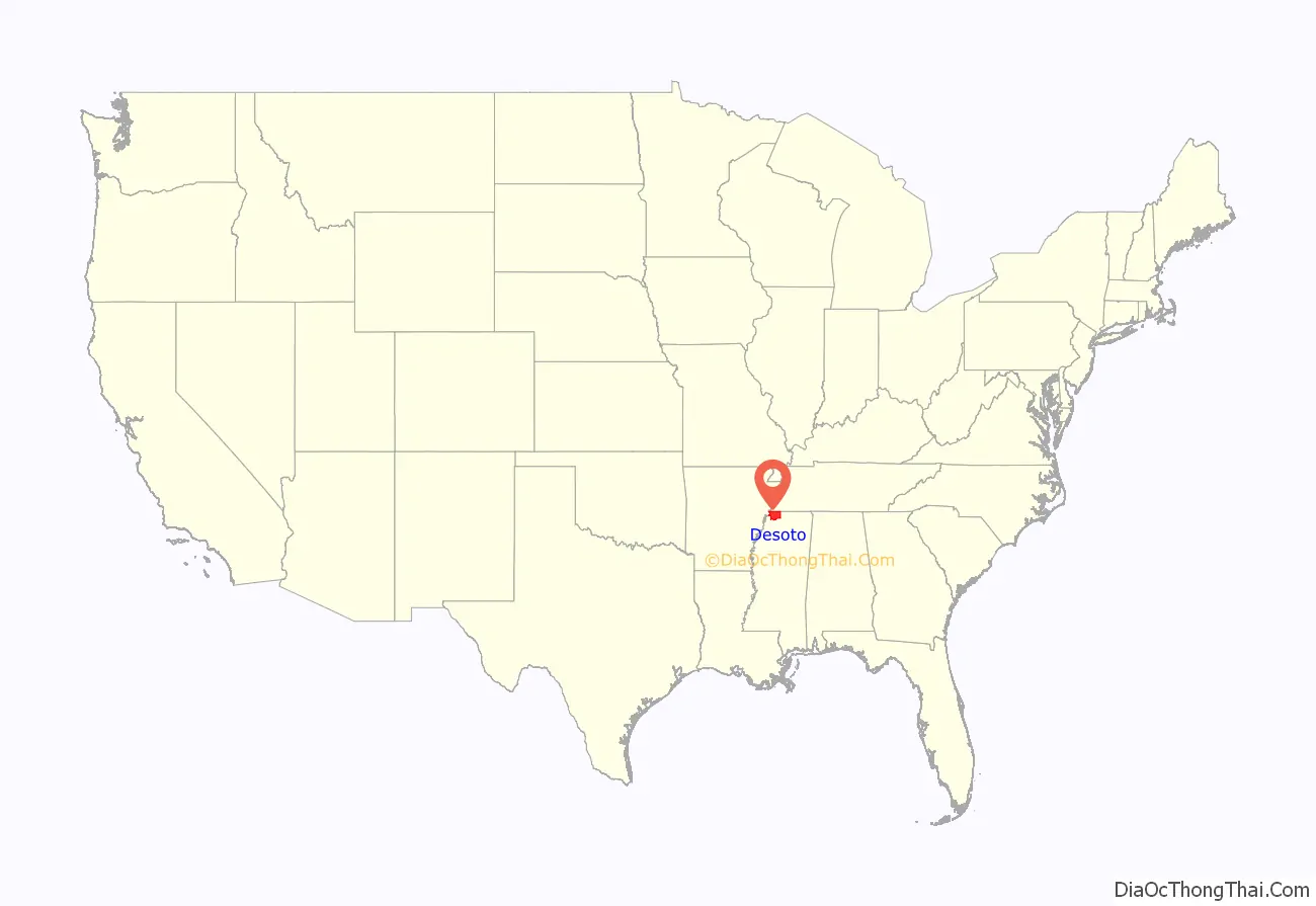
Desoto County location map. Where is Desoto County?
History
The county is named for Spanish explorer Hernando de Soto, the first European explorer known to reach the Mississippi River. The county seat, Hernando, is also named in his honor. De Soto reportedly died in that area in May 1542, although some accounts suggest that he died near Lake Village, Arkansas. See here for a list of sites associated with the 16th-century De Soto Expedition.
Early history
Indian artifacts collected in DeSoto County link it with prehistoric groups of Woodland and Mississippian culture peoples. Members of the Mississippian culture, who built complex settlements and earthwork monuments throughout the Mississippi River Valley and its major tributaries, met Hernando DeSoto in the mid-16th century when he explored what is now North Mississippi. By tradition, he is believed to have traveled with his expedition through present-day DeSoto County. Some scholars speculate that DeSoto discovered the Mississippi River west of present-day Lake Cormorant, built rafts there, and crossed to present-day Crowley’s Ridge, Arkansas. Based on records of the expedition and archeology, the National Park Service has designated a “DeSoto Corridor” from Coahoma County, Mississippi to the Chickasaw Bluff in Memphis.
The Mississippian culture declined and disappeared, and in most areas this preceded European contact. Scholars speculate this may have followed changes in the environment. The town named Chicasa, which De Soto visited, was probably the ancestral home of the historical Chickasaw, who are descended from the Mississippian culture. They had lived in the area for centuries before white settlers began arriving. Present-day Pontotoc, Mississippi developed near the Chickasaw “Long Town,” which was composed of several villages near each other. The Chickasaw Nation regarded much of western present-day Tennessee and northern Mississippi as their traditional hunting grounds.
The Chickasaw traded furs for French goods, and the French established several small settlements among them. However, France ceded its claim to territories east of the Mississippi River to Britain in 1763, after having been defeated in the Seven Years’ War. The United States acquired the area from the British as part of the treaty that ended the American Revolution.
19th and 20th centuries
The Chickasaw finally ceded most of their land to the United States under pressure during Indian Removal, and a treaty in 1832. They were forced to remove to Indian Territory west of the Mississippi River.
Negotiations began in September 1816 between the United States government and the Chickasaw nation and concluded with the signing of the Treaty of Pontotoc in October 1832. During those 16 years, federal officials pressed the Chickasaw for cessions of land to extinguish their land claims to enable white settlement in their territory. Congress passed the Indian Removal Act in 1830, authorizing forcible removal if necessary to extinguish Native American claims in the Southeast. From 1832 to 1836, government surveyors mapped the 6,442,000 acres (26,070 km) of the Chickasaw domain and divided it into townships, ranges and sections. The Mississippi Legislature formed 10 new counties, including DeSoto, Tunica, Marshall, and Tate, from the territory.
By treaty, the land was assigned by sections of 640 acres (2.6 km) to individual Indian households. The Chickasaw, a numerically small tribe, were assigned 2,422,400 acres (9,803 km) of land by using that formula. The government declared the remainder as surplus and disposed of the remaining 400,000 acres (1,600 km) at public sale. The Indians received at least $1.25 per acre for their land. The government land sold for 75 cents per acre or less.
During and after the Civil War, the area was developed as large plantations by planters for cultivation of cotton, a leading commodity crop. Before the Civil War, they had depended on the labor of thousands of enslaved African Americans. After the war and emancipation, many freedmen stayed in the area, but shaped their own lives by working on small plots as sharecroppers or tenant farmers, rather than on large labor gangs on the plantations. Reliance on agriculture meant that the area did not develop much economically well into the 20th century, and both whites and blacks suffered economically.
In 1890, the state legislature disenfranchised most blacks under the new constitution, which used poll taxes and literacy tests to raise barriers to voter registration. In the early 20th century, many people left the rural county for cities to gain other opportunities. Most blacks could not vote in Mississippi until the late 1960s, after the passage of federal legislation.
During the Great Depression, the Southern Tenant Farmers Union was organized in 1934. It was open to both black and white sharecroppers and worked to gain better deals and fair accounting from local white landowners. Whites in DeSoto County resisted the effort. In 1935, a white lynch mob attacked early union organizer and minister Reverend T. A. Allen, shot him, and threw him into the Coldwater River. One account said that his body was weighted by chains and that authorities claimed it to be a suicide.
In its 2015 report on Lynching in America (2015), the Equal Justice Institute documented 12 lynchings in the county from 1877 to 1950. Most lynchings in the South took place around the turn of the 20th century.
Since the late 20th century, DeSoto has had considerable suburban development related to the growth of Memphis.
21st century
As part of the Memphis, Tennessee metropolitan area, the early-21st-century DeSoto County has become one of the 40 fastest-growing counties in the United States. That is attributed to suburban development as middle-class and wealthier blacks leave Memphis to acquire newer housing and commute to Memphis for work. Some observers have characterized the shift as black flight, but it is also typical of the pattern of postwar suburban growth in which people who could afford it moved to newer housing in suburbs.
Such suburban residential development in the county has been most noticeable in the Mississippi cities of Southaven, Olive Branch, and Horn Lake. Also stimulating development in the formerly rural area is the massive casino/resort complex, in the neighboring Tunica County, which is the third-largest gambling district in the United States.
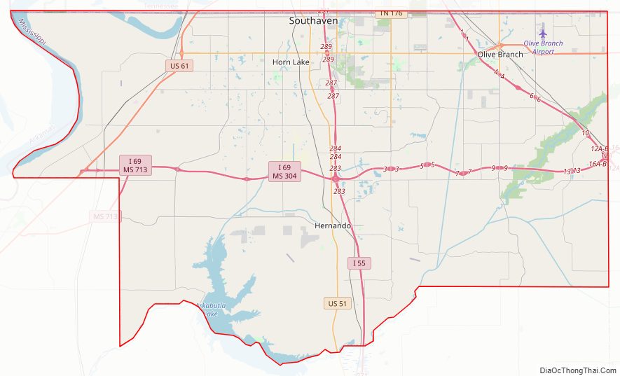
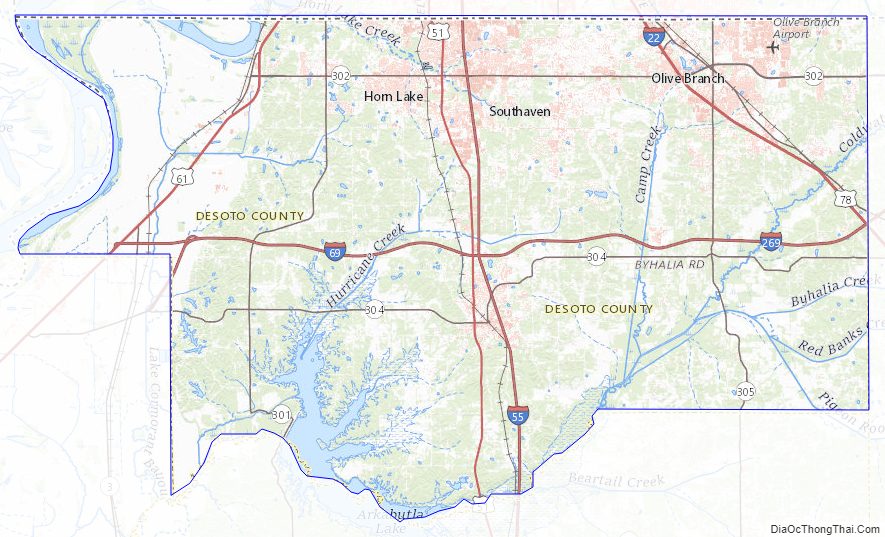
Desoto County Road Map
Geography
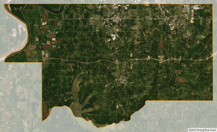
According to the U.S. Census Bureau, the county has a total area of 497 square miles (1,290 km), of which 476 square miles (1,230 km) is land and 21 square miles (54 km) (4.2%) is water.
Geographic features
- Mississippi River
- Coldwater River
- Arkabutla Lake
- Chickasaw Bluffs
Major highways
- Interstate 55
- Interstate 69
- Interstate 269
- U.S. Route 51
- U.S. Route 61
Adjacent counties
- Shelby County, Tennessee – north
- Crittenden County, Arkansas – west
- Tunica County – southwest
- Tate County – south
- Marshall County – east
Desoto County Topographic Map
Desoto County Satellite Map
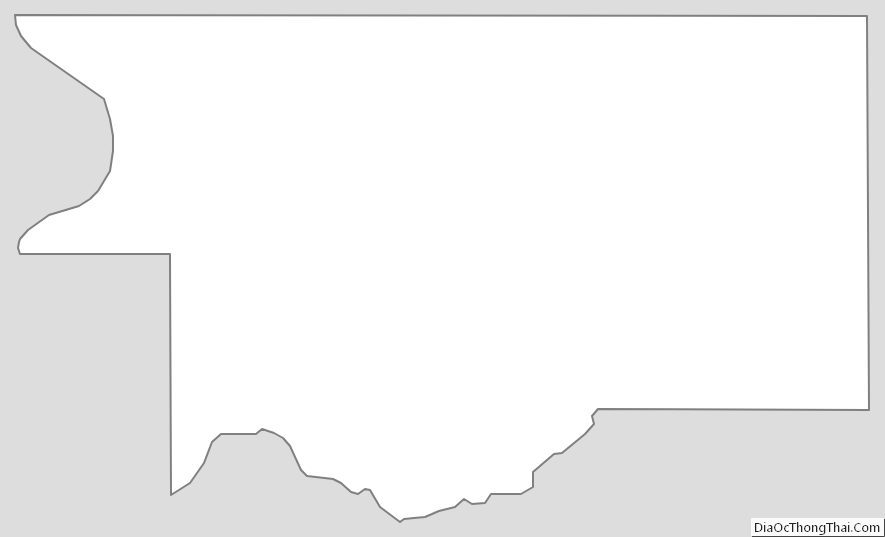
Desoto County Outline Map
See also
Map of Mississippi State and its subdivision:- Adams
- Alcorn
- Amite
- Attala
- Benton
- Bolivar
- Calhoun
- Carroll
- Chickasaw
- Choctaw
- Claiborne
- Clarke
- Clay
- Coahoma
- Copiah
- Covington
- Desoto
- Forrest
- Franklin
- George
- Greene
- Grenada
- Hancock
- Harrison
- Hinds
- Holmes
- Humphreys
- Issaquena
- Itawamba
- Jackson
- Jasper
- Jefferson
- Jefferson Davis
- Jones
- Kemper
- Lafayette
- Lamar
- Lauderdale
- Lawrence
- Leake
- Lee
- Leflore
- Lincoln
- Lowndes
- Madison
- Marion
- Marshall
- Monroe
- Montgomery
- Neshoba
- Newton
- Noxubee
- Oktibbeha
- Panola
- Pearl River
- Perry
- Pike
- Pontotoc
- Prentiss
- Quitman
- Rankin
- Scott
- Sharkey
- Simpson
- Smith
- Stone
- Sunflower
- Tallahatchie
- Tate
- Tippah
- Tishomingo
- Tunica
- Union
- Walthall
- Warren
- Washington
- Wayne
- Webster
- Wilkinson
- Winston
- Yalobusha
- Yazoo
- Alabama
- Alaska
- Arizona
- Arkansas
- California
- Colorado
- Connecticut
- Delaware
- District of Columbia
- Florida
- Georgia
- Hawaii
- Idaho
- Illinois
- Indiana
- Iowa
- Kansas
- Kentucky
- Louisiana
- Maine
- Maryland
- Massachusetts
- Michigan
- Minnesota
- Mississippi
- Missouri
- Montana
- Nebraska
- Nevada
- New Hampshire
- New Jersey
- New Mexico
- New York
- North Carolina
- North Dakota
- Ohio
- Oklahoma
- Oregon
- Pennsylvania
- Rhode Island
- South Carolina
- South Dakota
- Tennessee
- Texas
- Utah
- Vermont
- Virginia
- Washington
- West Virginia
- Wisconsin
- Wyoming