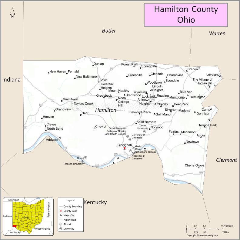
Hamilton County is located in the southwestern corner of the U.S. state of Ohio. As of the 2020 census, the population was 830,639, making it the third-most populous county in Ohio. The county seat and largest city is Cincinnati. The county is named for the first Secretary of the Treasury, Alexander Hamilton. Hamilton County is part of the Cincinnati-Middletown, OH-KY-IN Metropolitan Statistical Area.
| Name: | Hamilton County |
|---|---|
| FIPS code: | 39-061 |
| State: | Ohio |
| Founded: | January 2, 1790 |
| Named for: | Alexander Hamilton |
| Seat: | Cincinnati |
| Largest city: | Cincinnati |
| Total Area: | 413 sq mi (1,070 km²) |
| Land Area: | 406 sq mi (1,050 km²) |
| Total Population: | 830,639 |
| Population Density: | 2,000/sq mi (780/km²) |
| Time zone: | UTC−5 (Eastern) |
| Summer Time Zone (DST): | UTC−4 (EDT) |
| Website: | www.hamilton-co.org |
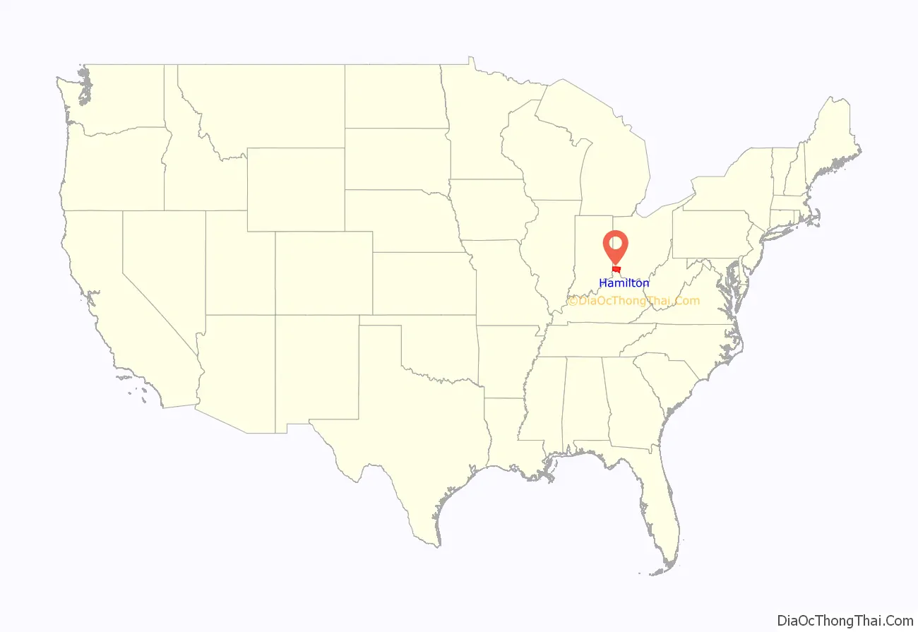
Hamilton County location map. Where is Hamilton County?
History
The southern portion of Hamilton County was originally owned and surveyed by John Cleves Symmes, and the region was a part of the Symmes Purchase. The first settlers rafted down the Ohio River in 1788 following the American Revolutionary War. They established the towns of Losantiville (later Cincinnati), North Bend, and Columbia.
Hamilton County was organized in 1790 by order of Arthur St. Clair, governor of the Northwest Territory, as the second county in the Northwest Territory. Cincinnati was named as the seat. Residents named the county in honor of Alexander Hamilton, who was the first Secretary of the Treasury of the United States and a founder of the Federalist Party. Its original boundaries were those defined for the Symmes purchase contract in 1788: the Ohio River in the South, Great Miami River to the west, the Lesser Miami River to the east, and the Cuyahoga River to the North. Its area then included about one-eighth of Ohio, and had about 2,000 inhabitants (not including the remaining Native Americans).
The county was greatly expanded in 1792 to include what is today the lower peninsula of Michigan. Since 1796, other counties were created from Hamilton, reducing the county to its present size. The county was the location of much of the Northwest Indian War both before and after its organization.
The United States forcibly removed most of the Shawnee and other Indian peoples to move to locations west of the Mississippi River in the 1820s.
Rapid growth occurred during the 1830s and 1840s as the area attracted many German and Irish immigrants, especially after the Great Famine in Ireland and the revolutions in Germany in 1848.
During the Civil War, Morgan’s Raid (a Confederate cavalry campaign from Kentucky) passed through the northern part of the county during the summer of 1863.
The Sharonville Engineer Depot was constructed by the United States Army in northern Hamilton County in 1942, and continued to be used by the General Services Administration and then the Defense Logistics Agency after 1949. It is currently mostly redeveloped for industrial purposes.
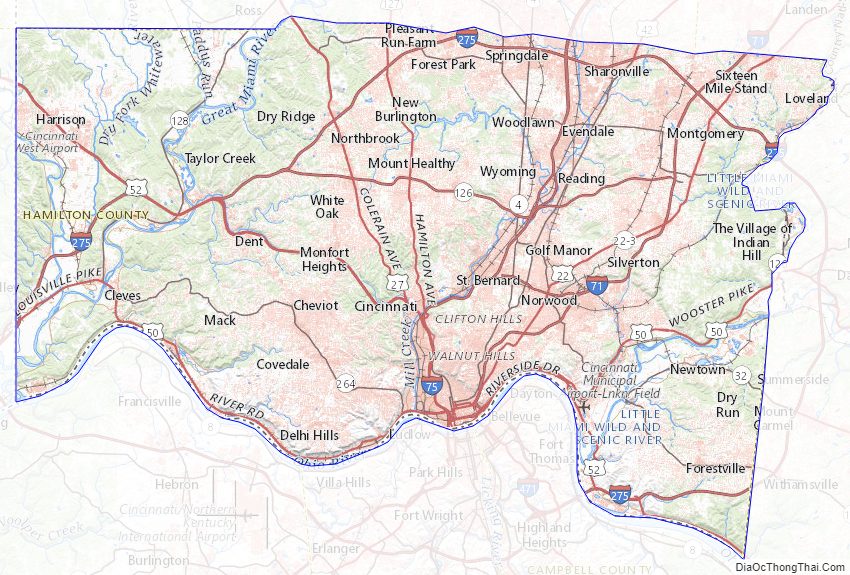
Hamilton County Road Map
Geography
According to the U.S. Census Bureau, the county has a total area of 413 square miles (1,070 km), of which 406 square miles (1,050 km) is land and 6.7 square miles (17 km) (1.6%) is water.
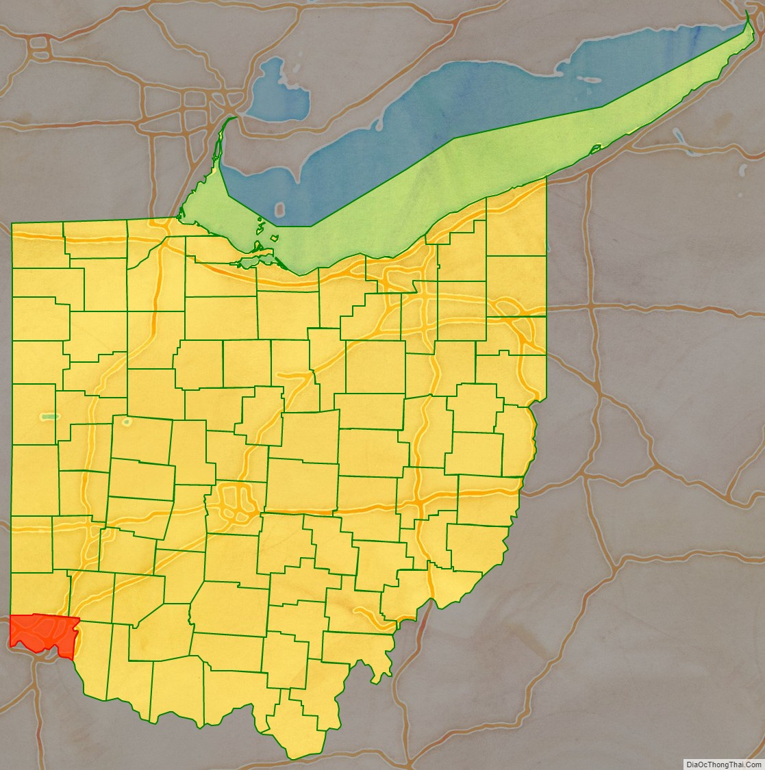
Adjacent counties
- Franklin County, Indiana (northwest)
- Dearborn County, Indiana (west)
- Butler County (north)
- Warren County (northeast)
- Clermont County (east)
- Campbell County, Kentucky (southeast)
- Kenton County, Kentucky (south)
- Boone County, Kentucky (southwest)
Geographic features
The county lies in a region of gentle hills formed by the slopes of the Ohio River valley and its tributaries. The Great Miami River, the Little Miami River, and the Mill Creek also contribute to this system of hillsides and valleys. No naturally occurring lakes exist, but three major manmade lakes are part of the Great Parks of Hamilton County. The largest lake by far is Winton Woods Lake, covering 188 surface acres, followed by Miami Whitewater Lake, covering 85 surface acres, and Sharon Lake, covering 36 surface acres.
The county boundaries include the lowest point in Ohio, in Miami Township, where the Ohio River flows out of Ohio and into Indiana. This is the upper pool elevation behind the Markland Dam, 455 feet (139 m) above sea level.
The highest land elevation in Hamilton County is the Rumpke Sanitary Landfill at 1,045 feet (319 m) above sea level in Colerain Township.
Major highways
- I-71
- I-74
- I-75
- I-275
- US 22
- US 27
- US 42
- US 50
- US 52
- US 127
- SR 3
- SR 4
- SR 32
- SR 125
- SR 126
- SR 128
- SR 264
Hamilton County Topographic Map
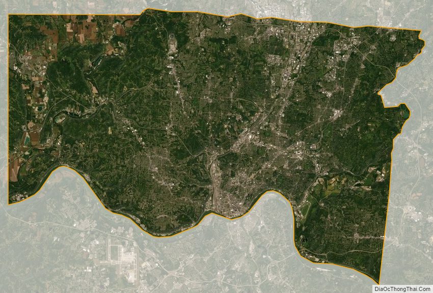
Hamilton County Satellite Map
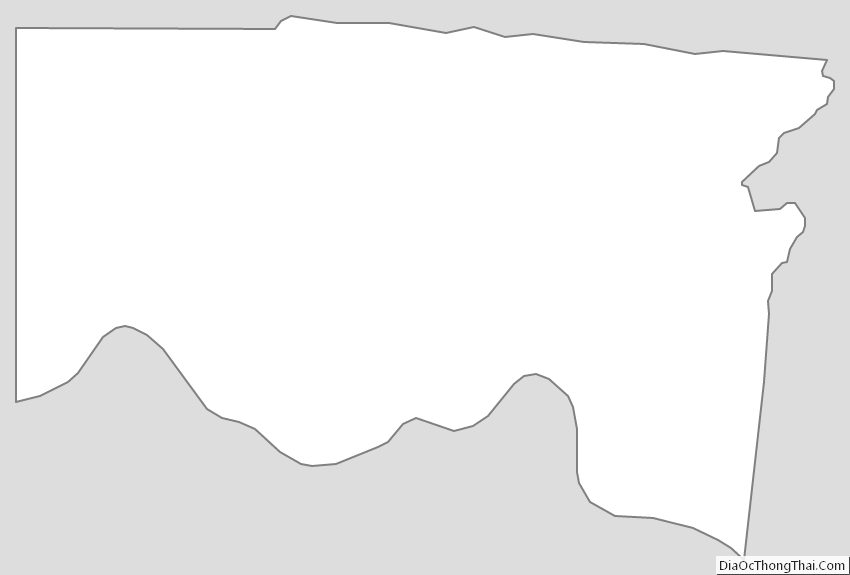
Hamilton County Outline Map
See also
Map of Ohio State and its subdivision:- Adams
- Allen
- Ashland
- Ashtabula
- Athens
- Auglaize
- Belmont
- Brown
- Butler
- Carroll
- Champaign
- Clark
- Clermont
- Clinton
- Columbiana
- Coshocton
- Crawford
- Cuyahoga
- Darke
- Defiance
- Delaware
- Erie
- Fairfield
- Fayette
- Franklin
- Fulton
- Gallia
- Geauga
- Greene
- Guernsey
- Hamilton
- Hancock
- Hardin
- Harrison
- Henry
- Highland
- Hocking
- Holmes
- Huron
- Jackson
- Jefferson
- Knox
- Lake
- Lake Erie
- Lawrence
- Licking
- Logan
- Lorain
- Lucas
- Madison
- Mahoning
- Marion
- Medina
- Meigs
- Mercer
- Miami
- Monroe
- Montgomery
- Morgan
- Morrow
- Muskingum
- Noble
- Ottawa
- Paulding
- Perry
- Pickaway
- Pike
- Portage
- Preble
- Putnam
- Richland
- Ross
- Sandusky
- Scioto
- Seneca
- Shelby
- Stark
- Summit
- Trumbull
- Tuscarawas
- Union
- Van Wert
- Vinton
- Warren
- Washington
- Wayne
- Williams
- Wood
- Wyandot
- Alabama
- Alaska
- Arizona
- Arkansas
- California
- Colorado
- Connecticut
- Delaware
- District of Columbia
- Florida
- Georgia
- Hawaii
- Idaho
- Illinois
- Indiana
- Iowa
- Kansas
- Kentucky
- Louisiana
- Maine
- Maryland
- Massachusetts
- Michigan
- Minnesota
- Mississippi
- Missouri
- Montana
- Nebraska
- Nevada
- New Hampshire
- New Jersey
- New Mexico
- New York
- North Carolina
- North Dakota
- Ohio
- Oklahoma
- Oregon
- Pennsylvania
- Rhode Island
- South Carolina
- South Dakota
- Tennessee
- Texas
- Utah
- Vermont
- Virginia
- Washington
- West Virginia
- Wisconsin
- Wyoming