Harris County is a county located in the U.S. state of Texas; as of the 2020 census, the population was 4,731,145, making it the most populous county in Texas and the third most populous county in the United States. Its county seat is Houston, the largest city in Texas and fourth largest city in the United States. The county was founded in 1836 and organized in 1837. It is named for John Richardson Harris, who founded the town of Harrisburg on Buffalo Bayou in 1826. According to the July 2021 census estimate, Harris County’s population has shifted to 4,728,030 comprising over 16% of Texas’s population. Harris County is included in the nine-county Houston–The Woodlands–Sugar Land metropolitan statistical area, which is the fifth-most populous metropolitan area in the United States.
| Name: | Harris County |
|---|---|
| FIPS code: | 48-201 |
| State: | Texas |
| Founded: | 1837 |
| Named for: | John Richardson Harris |
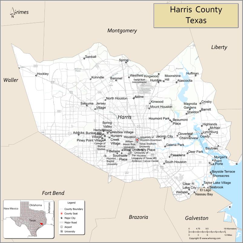
| Seat: | Houston |
| Largest city: | Houston |
| Total Area: | 1,778 sq mi (4,600 km²) |
| Land Area: | 1,703 sq mi (4,410 km²) |
| Total Population: | 4,731,145 |
| Population Density: | 2,700/sq mi (1,000/km²) |
| Time zone: | UTC−6 (Central) |
| Summer Time Zone (DST): | UTC−5 (CDT) |
| Website: | www.co.harris.tx.us |
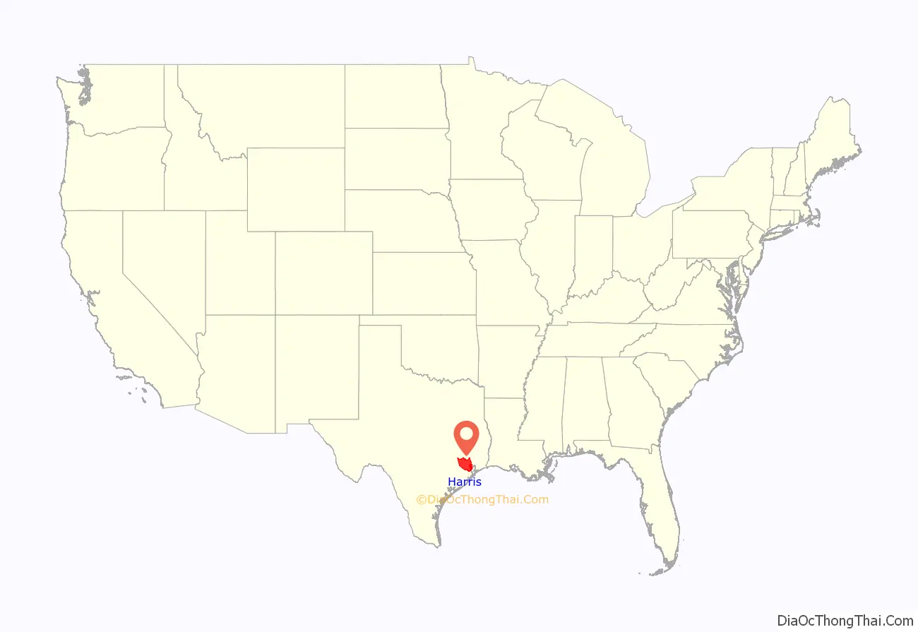
Harris County location map. Where is Harris County?
History
Human remains date habitation to about 4000 BC. Other evidence of humans in the area dates from about 1400 BC, 1 AD, and later in the first millennium. The region became uninhabited from 1 AD to European contact. Little European activity predates 1821. Álvar Núñez Cabeza de Vaca may have visited the area in 1529. French traders recorded passing through in the 18th century. Spaniards attempted to establish a fort in the area around the same time, but did not persist for long.
The first recorded European settlers in Harris County arrived in 1822. Their schooner sailed into Galveston Bay and ran aground on the Red Fish Bar. Some of those passengers traveled further up the bay system, but it is not known whether they settled up Buffalo Bayou or the San Jacinto River. One of these passengers, a Mr. Ryder, settled at what is now known as Morgan’s Point, Texas. Also in 1822, John Iiams settled his family at Cedar Point after sailing from Berwick’s Bay, Louisiana. Dr. Johnson Hunter arrived just after Iiams. He also wrecked his boat near Galveston. He settled at Morgan’s Point and was a grantee of land there. Nathaniel Lynch settled in the area and operated a ferry.
In 1824, the land empresario, Stephen F. Austin convened at the house of William Scott for the purpose of conveying titles for Mexican headrights. He was joined by the land commissioner, Baron von Bastrop, and Austin’s secretary, Samuel May Williams. About thirty families gained legal titles to land in what would later be known as Harris County. A few immigrants settled on Buffalo Bayou in these early years, including Moses Callahan, Ezekial Thomas, and the Vince brothers.
Nicolas Clopper arrived in the Galveston Bay area from Ohio in the 1820s. He attempted to develop Buffalo Bayou as a trading conduit for the Brazos River valley. He acquired land at Morgan’s Point in 1826. John Richardson Harris (1790–1829), for whom the county was later named, arrived in 1824. Harris had moved his family to Sainte Genevieve, Missouri Territory, where they had been residing until the early 1820s.
Harris was granted a league of land (about 4,428 acres) at Buffalo Bayou. He platted the town of Harrisburg in 1826, while he established a trading post and a grist mill there. He ran boats transporting goods between New Orleans and Harrisburg until his death in the fall of 1829.
The First Congress of the Republic of Texas established Harrisburg County on December 22, 1836. The original county boundaries included Galveston Island, but were redrawn to its current configuration in May 1838.
The area has had a number of severe weather events, such as the following hurricanes and tropical storms:
- 1900 Galveston
- 1943 Surprise Hurricane (1943)
- Carla (1961)
- Alicia (1983)
- Rita (2005)
- Ike (2008)
- Harvey (2017)
- Nicholas (2021)
- Allison (2001)
- Erin (2007)
- Imelda (2019)
- Beta (2020)
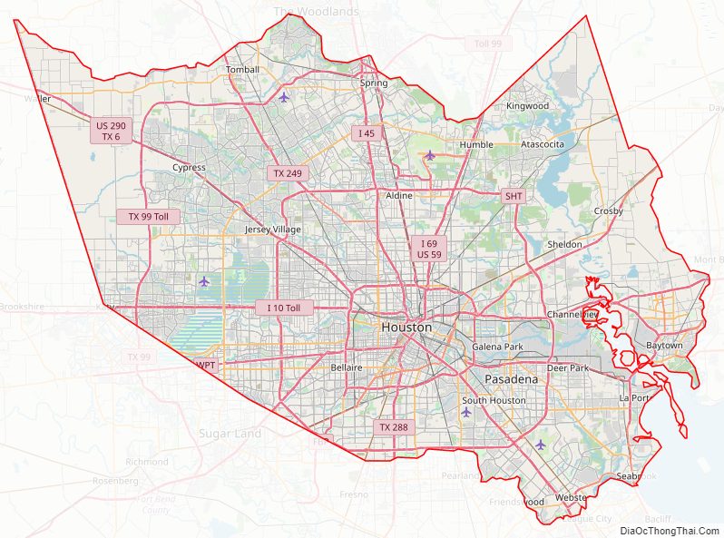
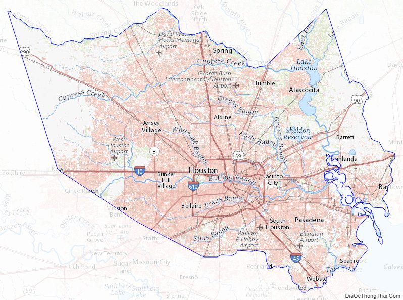
Harris County Road Map
Geography
According to the U.S. Census Bureau, the county has a total area of 1,777 square miles (4,600 km), of which 1,703 square miles (4,410 km) is land and 74 square miles (190 km) (4.2%) is covered by water. Both its total area and land area are larger than the U.S. state of Rhode Island.
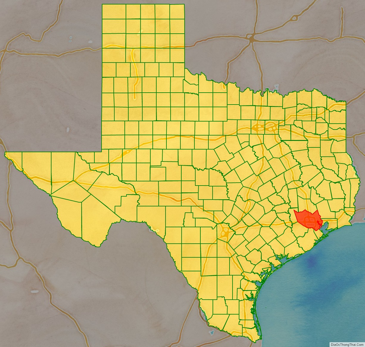
Adjacent counties
- Montgomery (north)
- Liberty (northeast)
- Chambers (east)
- Galveston (southeast)
- Brazoria (south)
- Fort Bend (southwest)
- Waller (northwest)
Harris County Topographic Map
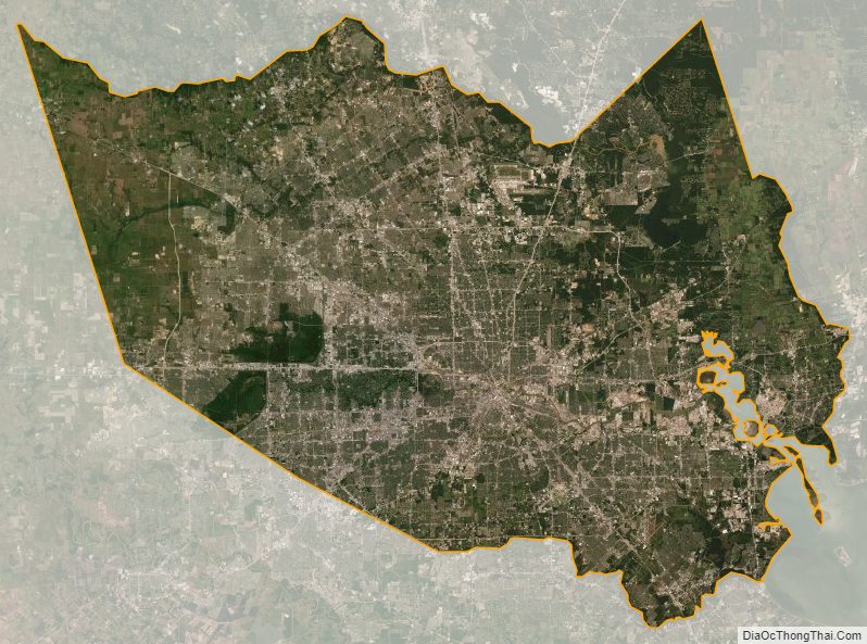
Harris County Satellite Map
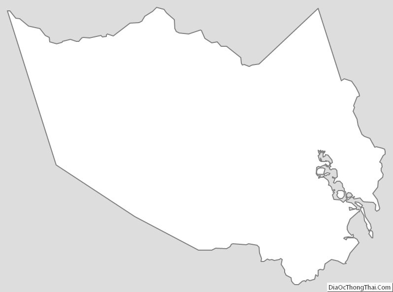
Harris County Outline Map
See also
Map of Texas State and its subdivision:- Anderson
- Andrews
- Angelina
- Aransas
- Archer
- Armstrong
- Atascosa
- Austin
- Bailey
- Bandera
- Bastrop
- Baylor
- Bee
- Bell
- Bexar
- Blanco
- Borden
- Bosque
- Bowie
- Brazoria
- Brazos
- Brewster
- Briscoe
- Brooks
- Brown
- Burleson
- Burnet
- Caldwell
- Calhoun
- Callahan
- Cameron
- Camp
- Carson
- Cass
- Castro
- Chambers
- Cherokee
- Childress
- Clay
- Cochran
- Coke
- Coleman
- Collin
- Collingsworth
- Colorado
- Comal
- Comanche
- Concho
- Cooke
- Coryell
- Cottle
- Crane
- Crockett
- Crosby
- Culberson
- Dallam
- Dallas
- Dawson
- Deaf Smith
- Delta
- Denton
- Dewitt
- Dickens
- Dimmit
- Donley
- Duval
- Eastland
- Ector
- Edwards
- El Paso
- Ellis
- Erath
- Falls
- Fannin
- Fayette
- Fisher
- Floyd
- Foard
- Fort Bend
- Franklin
- Freestone
- Frio
- Gaines
- Galveston
- Garza
- Gillespie
- Glasscock
- Goliad
- Gonzales
- Gray
- Grayson
- Gregg
- Grimes
- Guadalupe
- Hale
- Hall
- Hamilton
- Hansford
- Hardeman
- Hardin
- Harris
- Harrison
- Hartley
- Haskell
- Hays
- Hemphill
- Henderson
- Hidalgo
- Hill
- Hockley
- Hood
- Hopkins
- Houston
- Howard
- Hudspeth
- Hunt
- Hutchinson
- Irion
- Jack
- Jackson
- Jasper
- Jeff Davis
- Jefferson
- Jim Hogg
- Jim Wells
- Johnson
- Jones
- Karnes
- Kaufman
- Kendall
- Kenedy
- Kent
- Kerr
- Kimble
- King
- Kinney
- Kleberg
- Knox
- La Salle
- Lamar
- Lamb
- Lampasas
- Lavaca
- Lee
- Leon
- Liberty
- Limestone
- Lipscomb
- Live Oak
- Llano
- Loving
- Lubbock
- Lynn
- Madison
- Marion
- Martin
- Mason
- Matagorda
- Maverick
- McCulloch
- McLennan
- McMullen
- Medina
- Menard
- Midland
- Milam
- Mills
- Mitchell
- Montague
- Montgomery
- Moore
- Morris
- Motley
- Nacogdoches
- Navarro
- Newton
- Nolan
- Nueces
- Ochiltree
- Oldham
- Orange
- Palo Pinto
- Panola
- Parker
- Parmer
- Pecos
- Polk
- Potter
- Presidio
- Rains
- Randall
- Reagan
- Real
- Red River
- Reeves
- Refugio
- Roberts
- Robertson
- Rockwall
- Runnels
- Rusk
- Sabine
- San Augustine
- San Jacinto
- San Patricio
- San Saba
- Schleicher
- Scurry
- Shackelford
- Shelby
- Sherman
- Smith
- Somervell
- Starr
- Stephens
- Sterling
- Stonewall
- Sutton
- Swisher
- Tarrant
- Taylor
- Terrell
- Terry
- Throckmorton
- Titus
- Tom Green
- Travis
- Trinity
- Tyler
- Upshur
- Upton
- Uvalde
- Val Verde
- Van Zandt
- Victoria
- Walker
- Waller
- Ward
- Washington
- Webb
- Wharton
- Wheeler
- Wichita
- Wilbarger
- Willacy
- Williamson
- Wilson
- Winkler
- Wise
- Wood
- Yoakum
- Young
- Zapata
- Zavala
- Alabama
- Alaska
- Arizona
- Arkansas
- California
- Colorado
- Connecticut
- Delaware
- District of Columbia
- Florida
- Georgia
- Hawaii
- Idaho
- Illinois
- Indiana
- Iowa
- Kansas
- Kentucky
- Louisiana
- Maine
- Maryland
- Massachusetts
- Michigan
- Minnesota
- Mississippi
- Missouri
- Montana
- Nebraska
- Nevada
- New Hampshire
- New Jersey
- New Mexico
- New York
- North Carolina
- North Dakota
- Ohio
- Oklahoma
- Oregon
- Pennsylvania
- Rhode Island
- South Carolina
- South Dakota
- Tennessee
- Texas
- Utah
- Vermont
- Virginia
- Washington
- West Virginia
- Wisconsin
- Wyoming