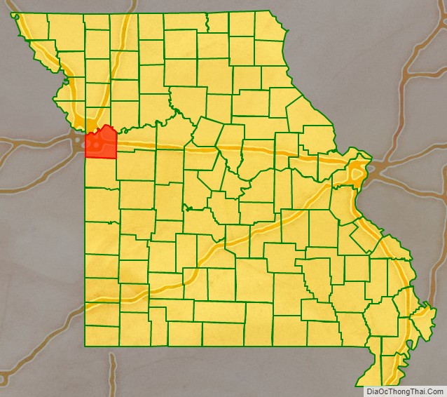
Jackson County is located in the western portion of the U.S. state of Missouri, on the border with Kansas. As of the 2020 census, the population was 717,204. making it the second-most populous county in the state (after St. Louis County in the east). It is the most populated county in the Kansas City metropolitan area.
Although Independence retains its status as the original county seat, Kansas City, Missouri, serves as a second county seat and the center of county government. The county was organized December 15, 1826, and named for former Tennessee senator Andrew Jackson, who would become President of the United States three years later in 1829. Total employment in 2019 was 344,993.
| Name: | Jackson County |
|---|---|
| FIPS code: | 29-095 |
| State: | Missouri |
| Founded: | December 15, 1826 |
| Named for: | Andrew Jackson |
| Seat: | Independence and Kansas City |
| Largest city: | Kansas City |
| Total Area: | 616 sq mi (1,600 km²) |
| Land Area: | 604 sq mi (1,560 km²) |
| Total Population: | 717,204 |
| Population Density: | 1,200/sq mi (450/km²) |
| Time zone: | UTC−6 (Central) |
| Summer Time Zone (DST): | UTC−5 (CDT) |
| Website: | www.jacksongov.org |
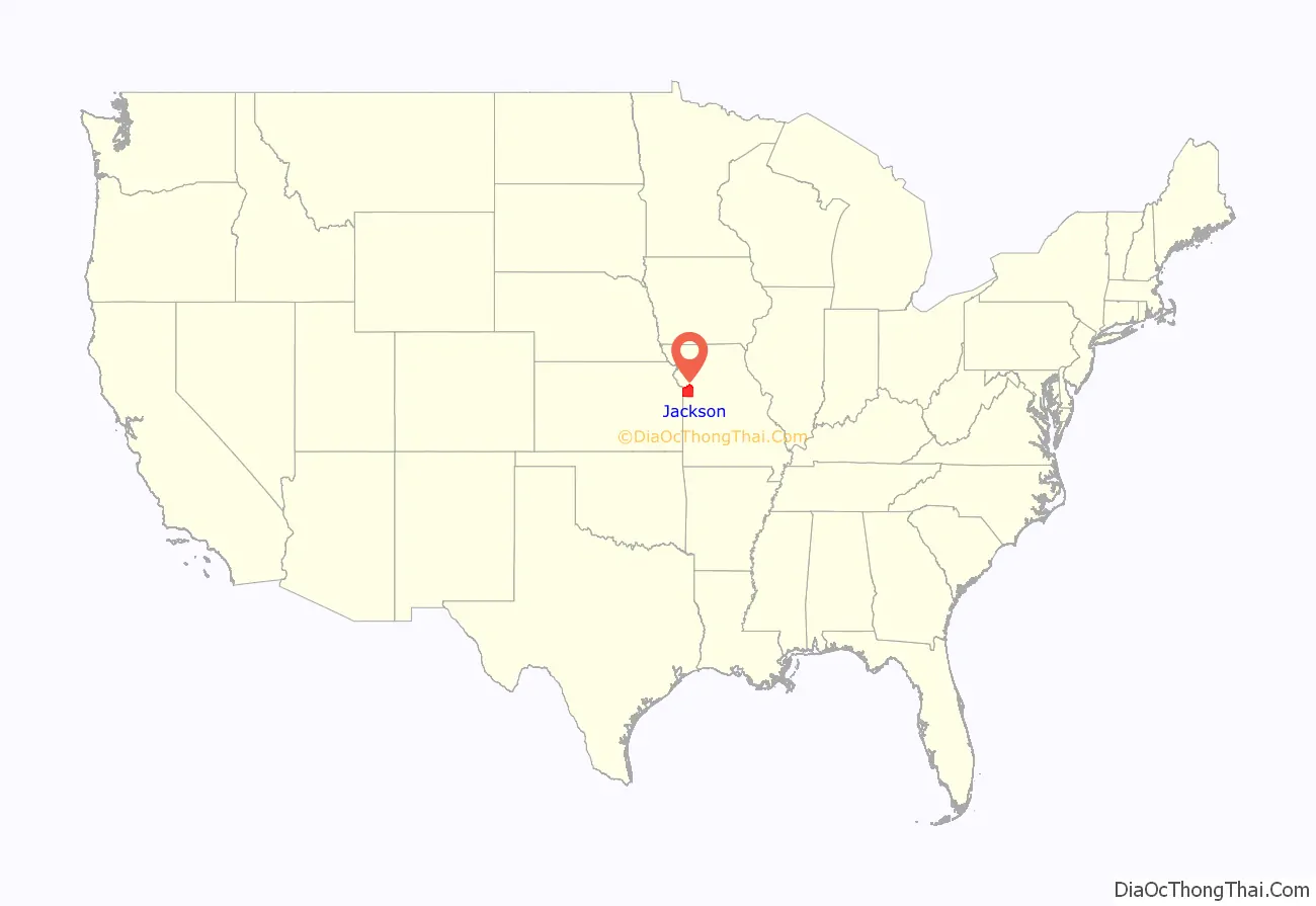
Jackson County location map. Where is Jackson County?
History
Early years
Jackson County was long home to members of the indigenous Osage tribe, who occupied this territory at the time of European encounter. The first known European explorers were French trappers who used the Missouri River as a highway for explorations and trading with regional Native American tribes. Jackson County was claimed as a part of the territory of New France, until 1763 and the British victory in the French and Indian War. After that, France ceded this territory west of the Mississippi River to Great Britain’s ally, Spain. In 1800 Spain was forced by France in the Third Treaty of San Ildefonso to return its Louisiana Territory (of which modern Jackson County formed a part) to France. Soon abandoning its claims in North America, Napoleon of France sold the territory to the United States in the Louisiana Purchase of 1803.
Operating on behalf of President Thomas Jefferson, explorers Meriwether Lewis and William Clark passed through Jackson County on their notable Lewis and Clark Expedition in 1804, to survey peoples, property and resources of the Louisiana Territory. Among other items, their report indicated a “high, commanding position” along the river within the current boundaries of Jackson County; in 1808 Fort Osage was constructed there. This stockade and trading post was one of the first U.S. military installations within the Louisiana Purchase territory, and remained active until 1822.
In 1821, Jackson County was included in the newly admitted state of Missouri. Jackson County was organized on December 15, 1826, and named for Andrew Jackson, U.S. Senator from Tennessee and military hero of the War of 1812, who would ascend to the Presidency shortly after, in 1829. Its county seat was designated as Independence, then a minuscule settlement near a spring. However, the rapid increase in westward exploration and expansion ultimately resulted in Independence becoming the starting point for three of the great Westward Trails: the Santa Fe Trail, the Oregon Trail, and the California Trail. Following the American Civil War and construction of railroads through this area, nearby Kansas City, Missouri, ultimately eclipsed Independence, though both towns remain county seats.
In 1838, the “Town Company” bought a small piece of land along the Missouri River in northern Jackson County, establishing “Westport Landing” (today this is known as the River Market district). The area outside Westport Landing was renamed in 1839 as the “Town of Kansas”, after the local Kanza or Kaw tribe.
The town was chartered by Jackson County in 1850 and incorporated by the State of Missouri in 1853 as the “City of Kansas”. In 1889, with a population of around 60,000, the city adopted a new charter and changed its name to Kansas City. In 1897, Kansas City annexed Westport.
Latter Day Saints
Jackson County figures prominently in the history of the Latter Day Saint movement. Although the sect was formed in upstate New York in 1830, in March 1831 Joseph Smith said that a location on the Missouri–Kansas border was to be the latter-day “New Jerusalem” with the “center place” located in Independence, the county seat. Traveling to the area in the Summer of 1831, Smith and some associates formally proclaimed Jackson County as the site, in a ceremony in August 1831.
Leadership and members of the Latter Day Saint movement began moving to Jackson County as soon as word was published of the August 1831 dedication ceremony. Open conflict with earlier settlers ensued, driven by religious and cultural differences. Many early settlers along the Missouri River had come from the Upper South: Kentucky and Tennessee, for instance, and brought their slaves and pro-slavery customs with them. They believed that the “Yankee” Mormons, from New York and northern states, were abolitionists. Mobs in the public and private sector used force to drive individual Saints from Jackson to nearby counties within Missouri; eventually, they put Latter Day Saints on notice that they had until the end of November 6, 1833, to leave the county en masse. On November 23, 1833, the few remaining LDS residents were ordered to leave Jackson County. By mid-1839, following the Missouri Mormon War, the LDS were driven from the state altogether. They did not return to Jackson County or Missouri in significant numbers until 1867, two years after the end of the Civil War.
Civil War
During the Civil War, Jackson County was the scene of several engagements, the most notable of which was the Battle of Westport in 1864, sometimes referred to as “the Gettysburg of Missouri”. The Union victory here firmly established Northern control of Missouri, and led to the failure of Confederate General Sterling Price’s Missouri expedition. Other noteworthy battles were fought in Independence in 1862, Lone Jack a few days later, and again in Independence in 1864.
Jackson County was strongly affected by Union General Thomas Ewing’s infamous General Order No. 11 (1863). With large numbers of Confederate sympathizers living within its boundaries, and active Confederate operations in the area a frequent occurrence, the Union command was determined to deprive Confederate bushwhackers of all local support. Ewing’s decree practically emptied the rural portions of the county, and resulted in the burning of large portions of Jackson and adjacent counties. According to American artist George Caleb Bingham, who described the order as “imbecilic” and was a resident of Kansas City at the time, one could see the “dense columns of smoke arising in every direction”, symbolic of what he termed “a ruthless military despotism which spared neither age, sex, character, nor condition”. Because of the destruction carried out under the order, its legacy haunted Jackson County for decades after the war.
Twentieth century
The coming of the railroads and the building of stockyards led to the rapid expansion of Kansas City in the late 19th century. During the 1920s and ’30s, the city became a noted center for Jazz and Blues music, as well as the headquarters of Hallmark Cards and the site of Walt Disney’s first animation studio. The county fared better than many during the Great Depression, as local political boss Thomas Pendergast worked to implement a $50,000,000 public works project that provided thousands of jobs. One of Pendergast’s political protegés was a young World War I veteran from Independence, Harry S. Truman, who had been his nephew’s commanding officer in the war. Truman was elected Presiding Judge (equivalent to a County Executive) of Jackson County with Pendergast support in 1926. He later was elected as a U.S. Senator from Missouri, Vice President and, in 1945, following the death of Franklin D. Roosevelt, succeeded him to become the thirty-third President of the United States. Truman was also elected president in 1948 in his own right.
Following World War II, developers followed new highways and created subdivisions for new housing, which increasingly encroached on rural portions of the county. They provided housing for the nation’s returning veterans and their young families. Independence, Blue Springs and Lee’s Summit underwent growth during this period, which continues to the present. Kansas City, on the other hand, suffered problems of urban decay as jobs and families left the industrial city, problems common to many large American cities in the late 20th century.
Recent building projects have sought to reverse this trend, including work on the city’s famous City Market, Westport district, 18th and Vine Historic District, and most recently, the Kansas City Power & Light District.
Some of the county’s local history is presented at the Pleasant Hill Historical Society Museum, in Pleasant Hill on the southern edge of the county.
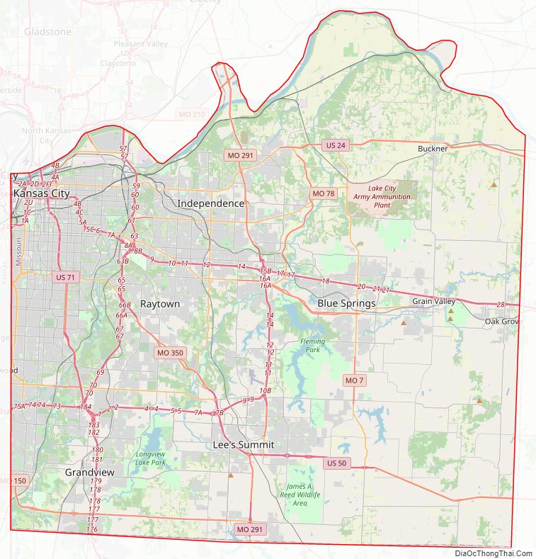
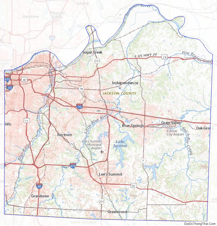
Jackson County Road Map
Geography
According to the United States Census Bureau, the county has a total area of 616 square miles (1,600 km), of which 604 square miles (1,560 km) is land and 12 square miles (31 km) (1.9%) is water.
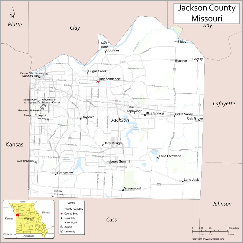
Notable Lakes include
- Longview Lake
- Lake Jacomo
- Blue Springs Lake
- Lake Lotawana
- Prairie Lee Lake
- Lake Tapawingo
The Missouri River comprises Jackson County’s northern border (with the exception of one small portion north of the river around the intersection of Highways 210 and 291 as well as all of the 291 bridge). The county has historically been a major traveling point for American river travel.
Adjacent counties
- Johnson County, Kansas (west/southwest)
- Clay County, Missouri (north)
- Wyandotte County, Kansas (west/northwest)
- Cass County, Missouri (south)
- Lafayette County, Missouri (east)
- Ray County (northeast)
- Johnson County, Missouri (southeast) – not part of the Kansas City metropolitan area
Major highways
- Interstate 29
- Interstate 35
- Interstate 49
- Interstate 70
Interstate 70 Alternate- Interstate 435
- Interstate 470
- Interstate 670
- U.S. Route 24
U.S. Route 24 Bus.- U.S. Route 40
- U.S. Route 50
- U.S. Route 56
- U.S. Route 71
- U.S. Route 169
- Route 7
- Route 150
- Route 291
- Route 350
National protected area
- Harry S Truman National Historic Site
Jackson County Topographic Map
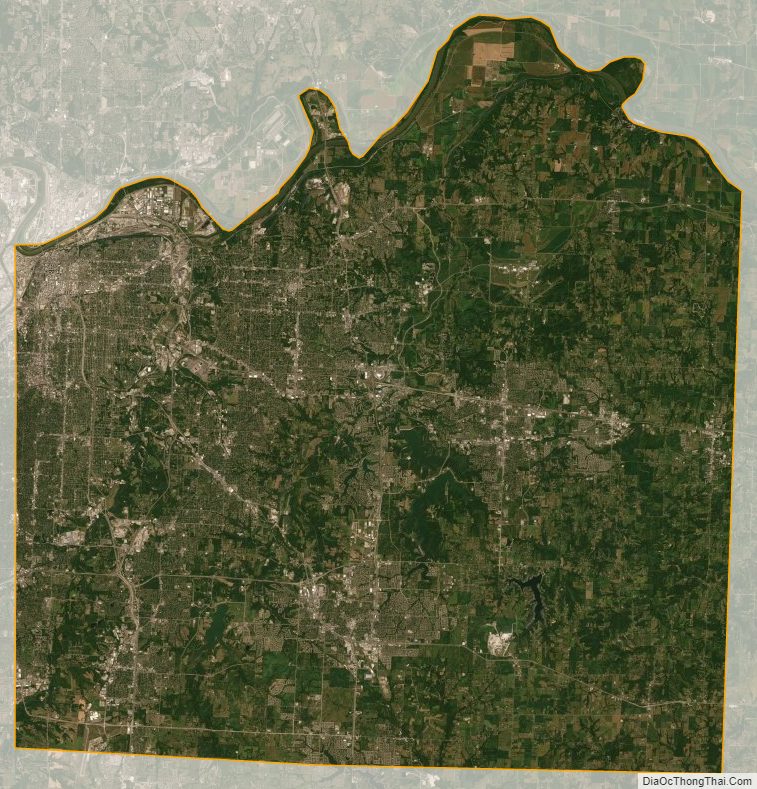
Jackson County Satellite Map
Jackson County Outline Map

See also
Map of Missouri State and its subdivision:- Adair
- Andrew
- Atchison
- Audrain
- Barry
- Barton
- Bates
- Benton
- Bollinger
- Boone
- Buchanan
- Butler
- Caldwell
- Callaway
- Camden
- Cape Girardeau
- Carroll
- Carter
- Cass
- Cedar
- Chariton
- Christian
- Clark
- Clay
- Clinton
- Cole
- Cooper
- Crawford
- Dade
- Dallas
- Daviess
- De Kalb
- Dent
- Douglas
- Dunklin
- Franklin
- Gasconade
- Gentry
- Greene
- Grundy
- Harrison
- Henry
- Hickory
- Holt
- Howard
- Howell
- Iron
- Jackson
- Jasper
- Jefferson
- Johnson
- Knox
- Laclede
- Lafayette
- Lawrence
- Lewis
- Lincoln
- Linn
- Livingston
- Macon
- Madison
- Maries
- Marion
- McDonald
- Mercer
- Miller
- Mississippi
- Moniteau
- Monroe
- Montgomery
- Morgan
- New Madrid
- Newton
- Nodaway
- Oregon
- Osage
- Ozark
- Pemiscot
- Perry
- Pettis
- Phelps
- Pike
- Platte
- Polk
- Pulaski
- Putnam
- Ralls
- Randolph
- Ray
- Reynolds
- Ripley
- Saint Charles
- Saint Clair
- Saint Francois
- Saint Louis
- Sainte Genevieve
- Saline
- Schuyler
- Scotland
- Scott
- Shannon
- Shelby
- Stoddard
- Stone
- Sullivan
- Taney
- Texas
- Vernon
- Warren
- Washington
- Wayne
- Webster
- Worth
- Wright
- Alabama
- Alaska
- Arizona
- Arkansas
- California
- Colorado
- Connecticut
- Delaware
- District of Columbia
- Florida
- Georgia
- Hawaii
- Idaho
- Illinois
- Indiana
- Iowa
- Kansas
- Kentucky
- Louisiana
- Maine
- Maryland
- Massachusetts
- Michigan
- Minnesota
- Mississippi
- Missouri
- Montana
- Nebraska
- Nevada
- New Hampshire
- New Jersey
- New Mexico
- New York
- North Carolina
- North Dakota
- Ohio
- Oklahoma
- Oregon
- Pennsylvania
- Rhode Island
- South Carolina
- South Dakota
- Tennessee
- Texas
- Utah
- Vermont
- Virginia
- Washington
- West Virginia
- Wisconsin
- Wyoming