Lycoming County is a county in the Commonwealth of Pennsylvania. As of the 2020 census, the population was 114,188. Its county seat is Williamsport.
Lycoming County comprises the Williamsport metropolitan statistical area.
About 130 miles (210 km) northwest of Philadelphia and 165 miles (270 km) east-northeast of Pittsburgh, Lycoming is Pennsylvania’s largest county by area.
| Name: | Lycoming County |
|---|---|
| FIPS code: | 42-081 |
| State: | Pennsylvania |
| Founded: | April 13, 1795 |
| Named for: | Lycoming Creek |
| Seat: | Williamsport |
| Largest city: | Williamsport |
| Total Area: | 1,244 sq mi (3,220 km²) |
| Land Area: | 1,229 sq mi (3,180 km²) |
| Total Population: | 114,188 |
| Population Density: | 93/sq mi (36/km²) |
| Time zone: | UTC−5 (Eastern) |
| Summer Time Zone (DST): | UTC−4 (EDT) |
| Website: | www.lyco.org |
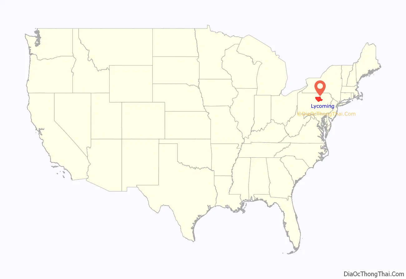
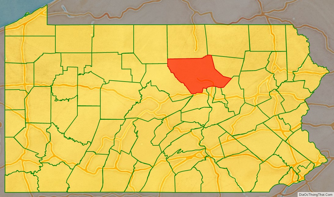
Lycoming County location map. Where is Lycoming County?
History
Formation of the county
Lycoming County was formed from Northumberland County on April 13, 1795. The county was larger than it is today. It took up most of the land that is now north central Pennsylvania. The following counties have been formed from land that was once part of Lycoming County: Armstrong, Bradford, Centre, Clearfield, Clinton, Indiana, Jefferson, McKean, Potter, Sullivan, Tioga, Venango, Warren, Forest, Elk and Cameron.
Lycoming County was originally named Jefferson County in honor of Thomas Jefferson. This name proved to be unsatisfactory. The name change went through several steps. First a change to Lycoming County was rejected, next the name Susquehanna County was struck down as was Muncy County, before the legislature revisited and settled on Lycoming County for Lycoming Creek, the stream that was the center of the pre-Revolutionary border dispute.
County “firsts”
1615: The first European in Lycoming County was Étienne Brûlé. He was a voyageur for New France. Brule descended the West Branch Susquehanna River and was held captive by a local Indian tribe near what is now Muncy before escaping and returning to Canada.
1761: The first permanent homes were built in Muncy. Three log cabins were built by Bowyer Brooks, Robert Roberts and James Alexander.
1772: The first gristmill is built on Muncy Creek by John Alward
1775: The first public road is built along the West Branch Susquehanna River. The road followed Indian trails from Fort Augusta in what is now Sunbury to Bald Eagle Creek near modern-day Lock Haven.
1786: The first church built in the county was Lycoming Presbyterian church in what was known as Jaysburg and is now the Newberry section of Williamsport.
1792: The first sawmill was built on Lycoming Creek by Roland Hall.
1795: The first elections for Lycoming County government are held soon after the county was formed from Northumberland County. The elected officers were Samuel Stewart, county sheriff and the first county commissioners were John Hanna, Thomas Forster and James Crawford. Andrew Gregg was elected to represent Lycoming County in the United States Congress, William Hepburn was voted to the Pennsylvania State Senate and Flavel Roan, Hugh White and Robert Martin served as representatives in the Pennsylvania General Assembly.
1823: The county government funded the construction of the first bridges over Loyalsock and Lycoming Creeks.
1839: The first railroad is built. It connected Williamsport with Ralston in northern Lycoming County. The railroad followed Lycoming Creek.
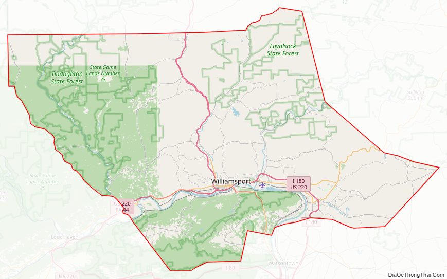
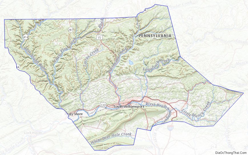
Lycoming County Road Map
Geography
According to the U.S. Census Bureau, the county has a total area of 1,244 square miles (3,220 km), of which 1,229 square miles (3,180 km) is land and 15 square miles (39 km) (1.2%) is water. Lycoming County is the largest county in Pennsylvania by land area and second-largest by total area; it is larger than the state of Rhode Island. The county has a humid continental climate which is warm-summer (Dfb) except in lower areas near the river which are hot-summer (Dfa). Average monthly temperatures in downtown Williamsport average from 26.5 °F in January to 72.4 °F in July, while in Trout Run they average from 25.5 °F in January to 71.2 °F in July. [2]
Appalachian Mountains and Allegheny Plateau
Lycoming County is divided between the Appalachian Mountains in the south, the dissected Allegheny Plateau (which also appears mountainous) in the north and east, and the valley of the West Branch Susquehanna River between these.
West Branch Susquehanna River
The West Branch of the Susquehanna enters Lycoming County from Clinton County just west of the borough of Jersey Shore, which is on the northwest bank of the river. The river then flows generally east and a little north with some large curves for 15 miles (24 kilometers) to the city of Williamsport, followed by the borough of Montoursville (both on the north bank) as well as the boroughs of Duboistown and South Williamsport (on the south bank).
The river flows just north of Bald Eagle Mountain (one of the northernmost ridges of the Ridge-and-valley Appalachians) through much of its course in Lycoming County, but it passes the end of the mountain and turns south just before the borough of Muncy (on the east bank). It continues south past the borough of Montgomery and leaves Lycoming County, where it forms the border between Union and Northumberland Counties. From there the West Branch merges with the North Branch Susquehanna River at Northumberland, Pennsylvania, and then flows south to the Chesapeake Bay.
Major creeks and watersheds
The major creeks of Lycoming County are all tributaries of the West Branch Susquehanna River. On the north or left bank of the river they are (from west to east): Pine Creek (and its tributary Little Pine Creek) which the river receives just west of Jersey Shore; Larrys Creek, which the river receives about 7 km (4 mi) south of Salladasburg; Lycoming Creek which the river receives in western Williamsport; Loyalsock Creek which the river receives between Williamsport and Montoursville; and Muncy Creek (and its tributary Little Muncy Creek), which the river receives just north of Muncy. Loyalsock and Muncy Creeks are also the major watersheds of Sullivan County.
Finally there is White Deer Hole Creek, the only major creek in Lycoming County on the right bank (i.e. south and west) of the river. It is south of Bald Eagle Mountain, and flows from west to east. The river receives it at the village of Allenwood in Gregg Township in Union County. Other creeks found on the right bank (south and west) of the West Branch Susquehanna River in Lycoming County are relatively minor, including Antes Creek in the Nippenose valley (in Limestone and Nippenose Townships), Mosquito Creek (at Duboistown), Hagermans Run (at South Williamsport), and Black Hole Creek (at Montgomery).
The entire county is in the Chesapeake Bay watershed. The percent of the county drained by each creek’s watershed is as follows: Pine Creek, 15.27%; Little Pine Creek, 11.25% (if these two are considered together, 26.52%); Larry’s Creek, 7.17%; Lycoming Creek, 17.80%; Loyalsock Creek, 13.23%; Muncy Creek, 4.82%; Little Muncy Creek, 5.86% (if these two are considered together, 10.68%); and White Deer Hole Creek, 4.40%. Minor creeks account for the rest.
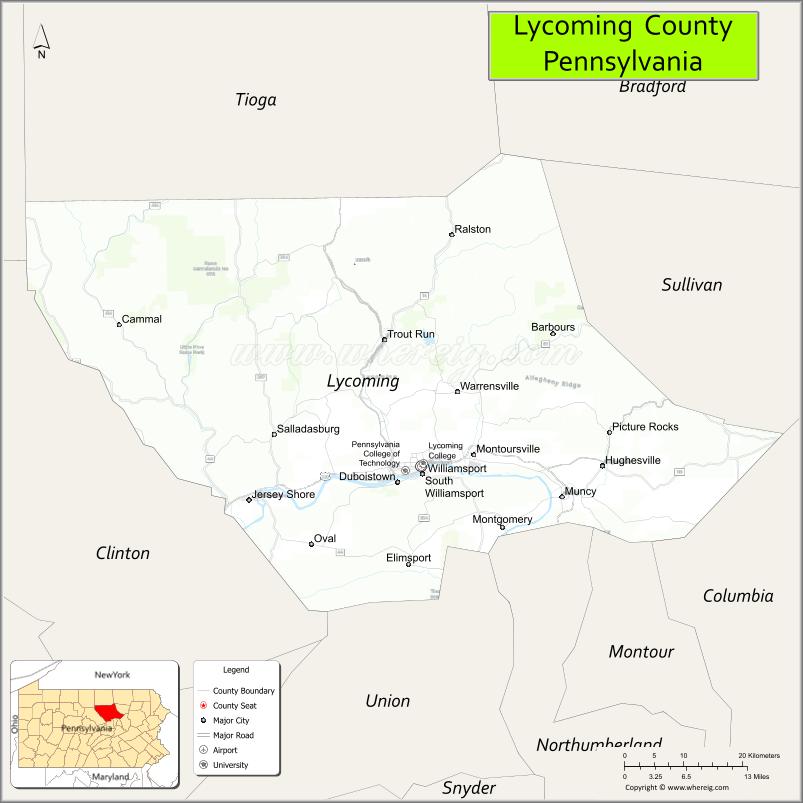
Adjacent counties
- Bradford County (northeast)
- Clinton County (west)
- Columbia County (southeast)
- Montour County (south)
- Northumberland County (south)
- Potter County (northwest)
- Sullivan County (east)
- Tioga County (north)
- Union County (southwest)
Lycoming County Topographic Map
Lycoming County Satellite Map
Lycoming County Outline Map
See also
Map of Pennsylvania State and its subdivision:- Adams
- Allegheny
- Armstrong
- Beaver
- Bedford
- Berks
- Blair
- Bradford
- Bucks
- Butler
- Cambria
- Cameron
- Carbon
- Centre
- Chester
- Clarion
- Clearfield
- Clinton
- Columbia
- Crawford
- Cumberland
- Dauphin
- Delaware
- Elk
- Erie
- Fayette
- Forest
- Franklin
- Fulton
- Greene
- Huntingdon
- Indiana
- Jefferson
- Juniata
- Lackawanna
- Lancaster
- Lawrence
- Lebanon
- Lehigh
- Luzerne
- Lycoming
- Mc Kean
- Mercer
- Mifflin
- Monroe
- Montgomery
- Montour
- Northampton
- Northumberland
- Perry
- Philadelphia
- Pike
- Potter
- Schuylkill
- Snyder
- Somerset
- Sullivan
- Susquehanna
- Tioga
- Union
- Venango
- Warren
- Washington
- Wayne
- Westmoreland
- Wyoming
- York
- Alabama
- Alaska
- Arizona
- Arkansas
- California
- Colorado
- Connecticut
- Delaware
- District of Columbia
- Florida
- Georgia
- Hawaii
- Idaho
- Illinois
- Indiana
- Iowa
- Kansas
- Kentucky
- Louisiana
- Maine
- Maryland
- Massachusetts
- Michigan
- Minnesota
- Mississippi
- Missouri
- Montana
- Nebraska
- Nevada
- New Hampshire
- New Jersey
- New Mexico
- New York
- North Carolina
- North Dakota
- Ohio
- Oklahoma
- Oregon
- Pennsylvania
- Rhode Island
- South Carolina
- South Dakota
- Tennessee
- Texas
- Utah
- Vermont
- Virginia
- Washington
- West Virginia
- Wisconsin
- Wyoming