McIntosh County is a county located in the U.S. state of Oklahoma. As of the 2010 census, the population was 20,252. Its county seat is Eufaula. The county is named for an influential Muscogee Creek family, whose members led the migration of the Lower Towns to Indian Territory and served as leaders for generations.
It is one of the counties within the jurisdiction of the federally recognized Muscogee (Creek) Nation; a small portion is within the jurisdiction of the Cherokee Nation of Oklahoma.
| Name: | McIntosh County |
|---|---|
| FIPS code: | 40-091 |
| State: | Oklahoma |
| Founded: | 1907 |
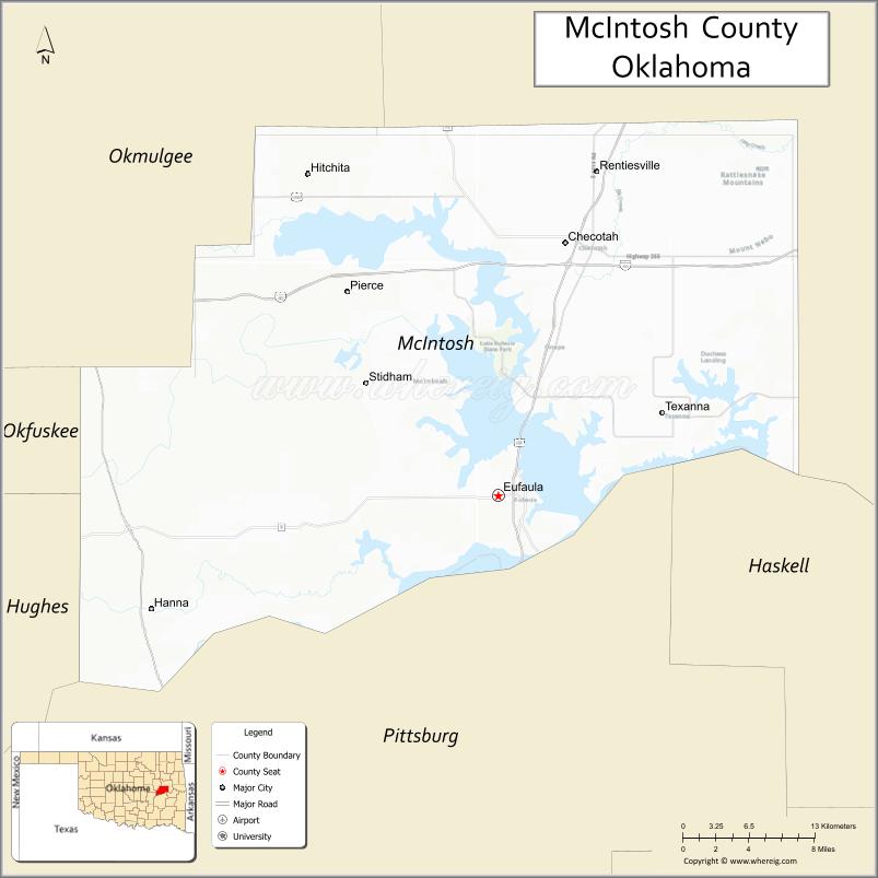
| Seat: | Eufaula |
| Largest city: | Checotah |
| Total Area: | 712 sq mi (1,840 km²) |
| Land Area: | 618 sq mi (1,600 km²) |
| Total Population: | 20,252 |
| Population Density: | 33/sq mi (13/km²) |
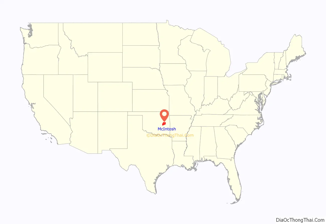
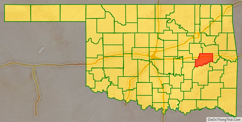
McIntosh County location map. Where is McIntosh County?
History
Many archaeological sites in McIntosh County date back to the Archaic period in North America (6000 BC – 1 AD). (Ed. note: the Encyclopedia of Oklahoma History and Culture defines this period as written here. The definition differs from that shown by the linked Wikipedia article.) Archaeologists have uncovered six sites since 2003 that predate these. These indigenous peoples predated any of Plains Indians, as well as the tribes that settled in the territory in the 1830s following Indian Removal from the American Southeast. Indigenous people may have made petroglyphs at the Handprint Site before the coming of the earliest European explorers.
In 1825, the Creek of the Lower Towns in the territory of present-day Georgia, led by William McIntosh, agreed by the Treaty of Indian Springs with the United States, to exchange their land in Georgia for land in Indian Territory. These Creek were a historic people who had originated in the Southeast and were part of the larger Creek Confederacy for centuries. Much of their new territory was included in what later became McIntosh County. Chief McIntosh was executed in Georgia in 1825 by order of the Creek National Council, which had forbidden such land cessions without agreement by the full council.
His descendants and followers of the Lower Towns migrated to Indian Territory. There the Creek repeatedly battled with the Osage, who had historically occupied a large area including this and up through present-day Missouri. In 1836, the Creek established North Fork Town on the Texas Road, about two miles east of present-day Eufaula, Oklahoma. A post office named Micco operated in North Fork Town from 1853 to 1886. This area became part of the Eufaula District of the Creek Nation.
Albert Pike, representing the Confederate States of America, signed treaties with the Chickasaw, Choctaw and Creek nations at the beginning of the Civil War. They allied with the Confederacy in the hopes of gaining an Indian state after the war. The Battle of Honey Springs, the largest battle of the war in what is now Oklahoma, was fought near Rentiesville. The Union Army won and took control of that part of Indian Territory north of the Arkansas River.
The Missouri-Kansas-Texas Railway built a line through this area in 1871–2, generally following the Texas Road. The communities of Checotah and Eufaula were established then. In 1904–5, the Missouri, Oklahoma and Gulf Railway (later merged into the Kansas, Oklahoma and Gulf Railway) laid a line through the northwestern part of the area, starting the community of Hitchita.
McIntosh County was established at statehood in 1907, when the population was 17,975. Before statehood, the area had been part of the Eufaula District of the Creek Nation. The county gained some land from Hughes County in 1915, but lost some land to Okmulgee County in 1918. The former moved the community of Hanna from Hughes County. The latter moved the towns of Grayson and Hoffman into Okmulgee County.
Between 1907 and 1909, the people of Checotah were involved in a dispute with nearby Eufaula known as the McIntosh County Seat War. After Checotah was designated as the new county seat, the people of Eufaula refused to hand over the county records. Soon after, a group of heavily armed men from Chectotah attempted to seize the records from the courthouse in Eufaula, but were beaten back and forced to surrender during the gunfight that followed. Eufaula was designated as the permanent seat of McIntosh County one year later.
The county is mostly within the jurisdiction of the federally recognized Muscogee (Creek) Nation, which oversees and represents its members. The far eastern portion of the county is within the jurisdiction of the Cherokee Nation of Oklahoma. Native Americans, mostly Muscogee, comprise more than 16% of the county’s population.
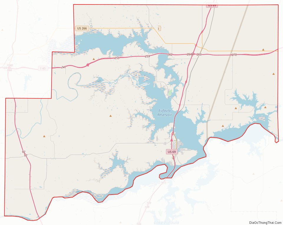
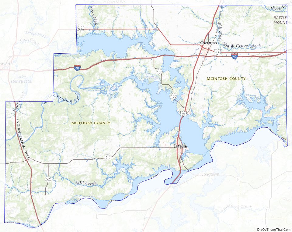
McIntosh County Road Map
Geography
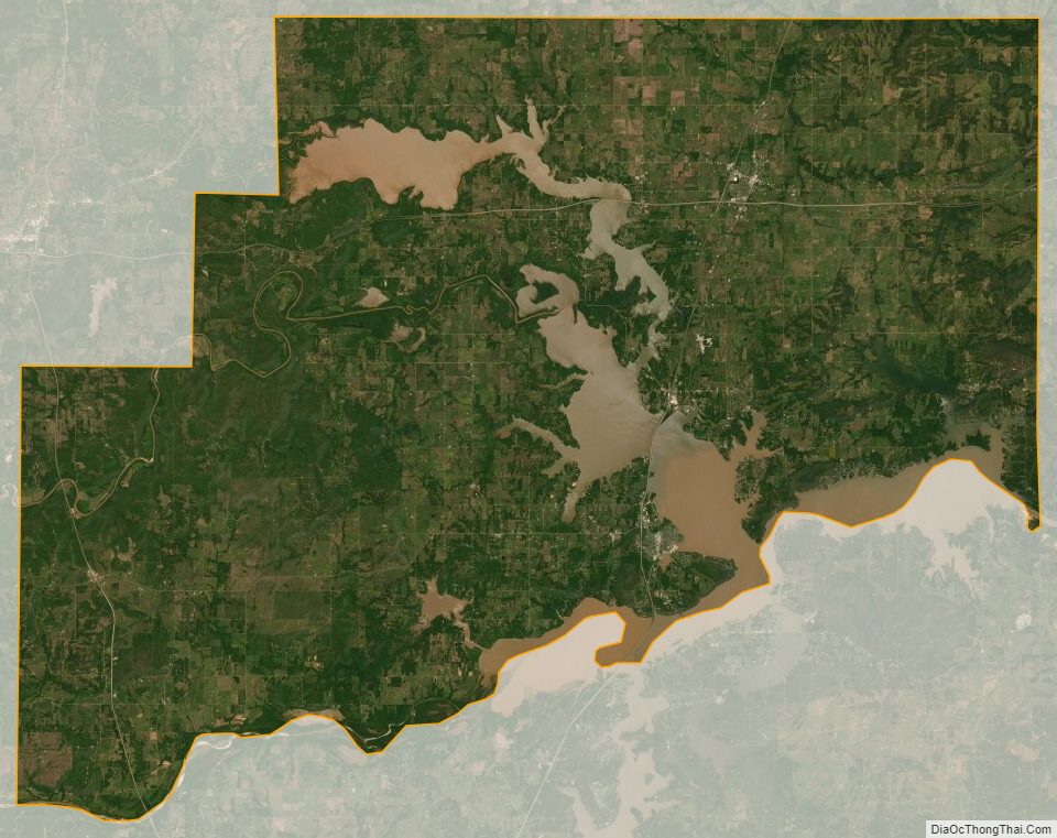
According to the U.S. Census Bureau, the county has a total area of 712 square miles (1,840 km), of which 618 square miles (1,600 km) is land and 94 square miles (240 km) (13%) is water. Much of the water surface is attributable to Eufaula Lake, the largest reservoir entirely within the state. Checotah is the nearest city to Lake Eufaula State Park (formerly Fountainhead State Park). The county is drained by the Deep Fork River, North Canadian River and Canadian River.
Major highways
- Interstate 40
- U.S. Highway 69
- U.S. Highway 266
- State Highway 9
- State Highway 72
- Indian Nation Turnpike
Adjacent counties
- Muskogee County (northeast)
- Haskell County (southeast)
- Pittsburg County (south)
- Hughes County (southwest)
- Okfuskee County (west)
- Okmulgee County (northwest)
McIntosh County Topographic Map
McIntosh County Satellite Map
McIntosh County Outline Map
See also
Map of Oklahoma State and its subdivision:- Adair
- Alfalfa
- Atoka
- Beaver
- Beckham
- Blaine
- Bryan
- Caddo
- Canadian
- Carter
- Cherokee
- Choctaw
- Cimarron
- Cleveland
- Coal
- Comanche
- Cotton
- Craig
- Creek
- Custer
- Delaware
- Dewey
- Ellis
- Garfield
- Garvin
- Grady
- Grant
- Greer
- Harmon
- Harper
- Haskell
- Hughes
- Jackson
- Jefferson
- Johnston
- Kay
- Kingfisher
- Kiowa
- Latimer
- Le Flore
- Lincoln
- Logan
- Love
- Major
- Marshall
- Mayes
- McClain
- McCurtain
- McIntosh
- Murray
- Muskogee
- Noble
- Nowata
- Okfuskee
- Oklahoma
- Okmulgee
- Osage
- Ottawa
- Pawnee
- Payne
- Pittsburg
- Pontotoc
- Pottawatomie
- Pushmataha
- Roger Mills
- Rogers
- Seminole
- Sequoyah
- Stephens
- Texas
- Tillman
- Tulsa
- Wagoner
- Washington
- Washita
- Woods
- Woodward
- Alabama
- Alaska
- Arizona
- Arkansas
- California
- Colorado
- Connecticut
- Delaware
- District of Columbia
- Florida
- Georgia
- Hawaii
- Idaho
- Illinois
- Indiana
- Iowa
- Kansas
- Kentucky
- Louisiana
- Maine
- Maryland
- Massachusetts
- Michigan
- Minnesota
- Mississippi
- Missouri
- Montana
- Nebraska
- Nevada
- New Hampshire
- New Jersey
- New Mexico
- New York
- North Carolina
- North Dakota
- Ohio
- Oklahoma
- Oregon
- Pennsylvania
- Rhode Island
- South Carolina
- South Dakota
- Tennessee
- Texas
- Utah
- Vermont
- Virginia
- Washington
- West Virginia
- Wisconsin
- Wyoming