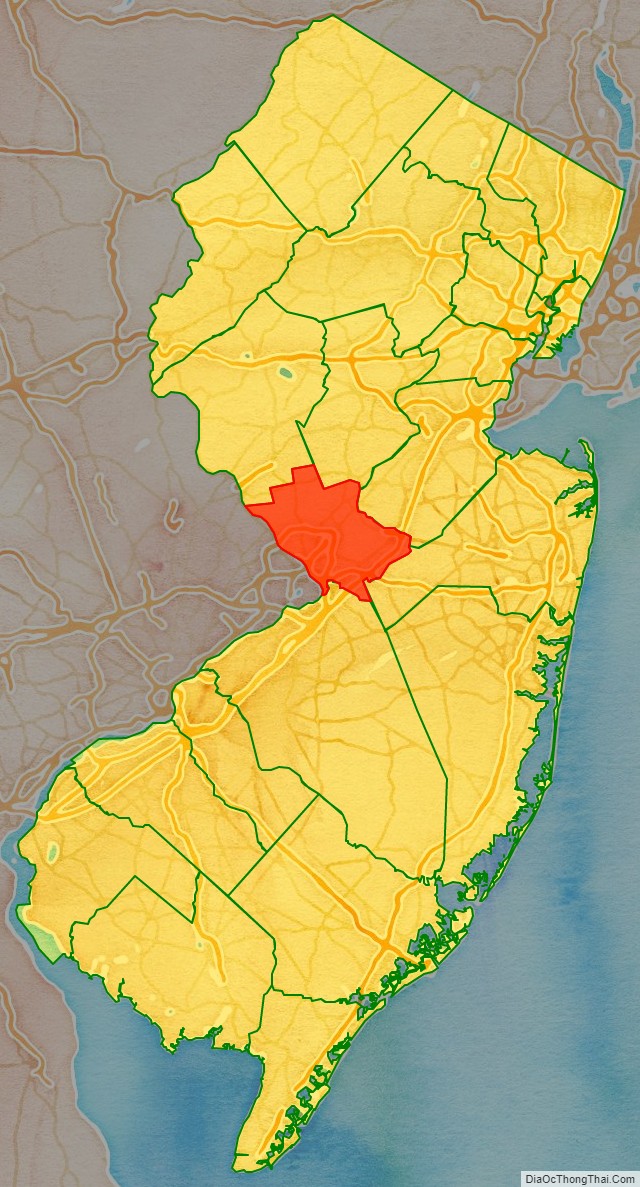
Mercer County is a county located in the U.S. state of New Jersey. Its county seat is Trenton, also the state capital, prompting its nickname The Capital County. Mercer County alone constitutes the Trenton–Princeton metropolitan statistical area and is considered part of the New York metropolitan area by the U.S. Census Bureau, but also directly borders the Philadelphia metropolitan area and is included within the Federal Communications Commission’s Philadelphia designated media market.
As of the 2020 United States census, the county retained its position as the state’s 12th-most-populous county, with a population of 387,340, its highest decennial count ever and an increase of 20,827 (+5.7%) from the 2010 census count of 366,513, which in turn reflected an increase of 15,752 (+4.5%) from the 350,761 enumerated in the 2000 census
The county was formed by an act of the New Jersey Legislature on February 22, 1838, from portions of Burlington County (Nottingham Township, now Hamilton Township), Hunterdon County (Ewing Township, Lawrence Township, Trenton, and portions of Hopewell Township), and Middlesex County, (West Windsor Township and portions of East Windsor Township). The former Keith Line bisects the county and is the boundary between municipalities that previously had been separated into West Jersey and East Jersey.
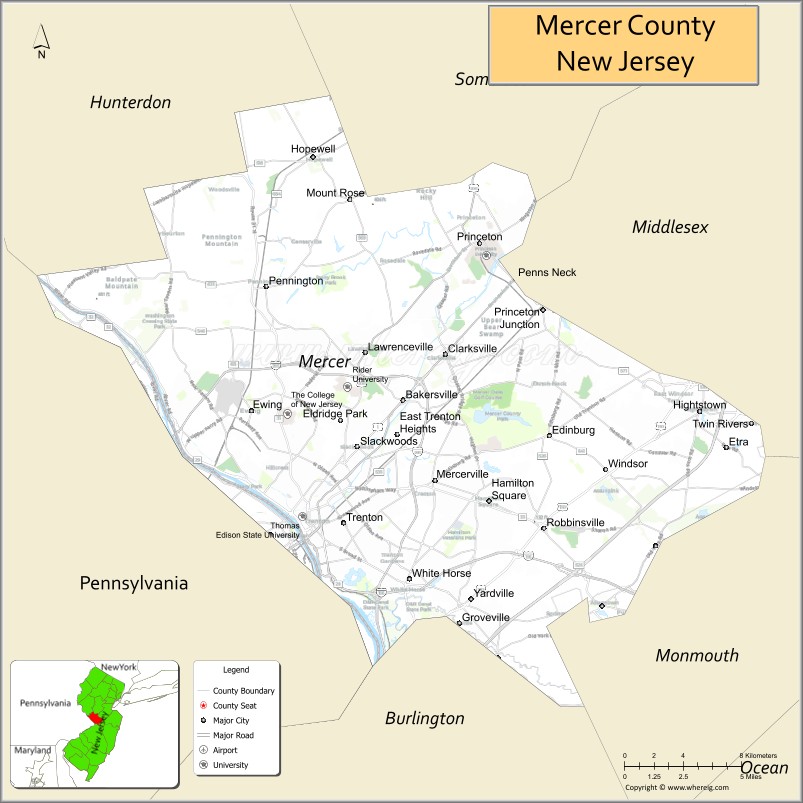
Trenton–Mercer Airport in Ewing Township is a commercial and corporate aviation airport serving Mercer County and its surrounding vicinity. The official residence of the governor of New Jersey, known as Drumthwacket, is located in Princeton, and is listed on both the U.S. National Register of Historic Places and the New Jersey Register of Historic Places. Mercer County contains 12 municipalities, the fewest of any county in New Jersey, and equal to Hudson County. The county is located in the Central Jersey region.
| Name: | Mercer County |
|---|---|
| FIPS code: | 34-021 |
| State: | New Jersey |
| Founded: | 1838 |
| Named for: | Hugh Mercer |
| Seat: | Trenton |
| Total Area: | 228.89 sq mi (592.8 km²) |
| Land Area: | 224.56 sq mi (581.6 km²) |
| Total Population: | 387,340 |
| Population Density: | 1,724.9/sq mi (666.0/km²) |
| Website: | www.mercercounty.org |
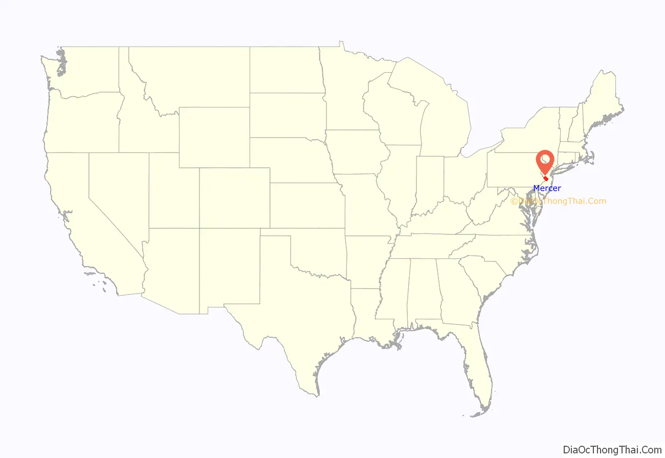
Mercer County location map. Where is Mercer County?
History
Etymology
The county was named for Continental Army General Hugh Mercer, who died as a result of wounds received at the Battle of Princeton on January 3, 1777. Continental Army Brigadier General Hugh Mercer served in the Continental Army during the Battles of Trenton and Princeton in 1777. A Scotsman that fled to British North America after the failed Jacobite Rebellion, he worked closely with George Washington in the American Revolution. On January 3, 1777, Washington’s army was en route to Princeton, New Jersey. While leading a vanguard of 350 soldiers, Mercer’s brigade encountered two British regiments and a mounted unit. A fight broke out at an orchard grove and Mercer’s horse was shot from under him. Getting to his feet, he was quickly surrounded by British troops who mistook him for George Washington and ordered him to surrender. Outnumbered, he drew his saber and began an unequal contest. He was finally beaten to the ground, bayoneted repeatedly (seven times), and left for dead. Legend has it that a beaten Mercer, with a bayonet still impaled in him, did not want to leave his men and the battle and was given a place to rest on a white oak tree’s trunk, and those who remained with him stood their ground. The Mercer Oak, against which the dying general rested as his men continued to fight, appears on the county seal and stood for 250 years until it collapsed in 2000.
History
Founded February 22, 1838, from portions of surrounding counties, Mercer County has a historical impact that reaches back to the pivotal battles of the American Revolutionary War. On the night of December 25–26, 1776, General George Washington led American forces across the Delaware River to attack the Hessian forces in the Battle of Trenton on the morning of December 26, also known as the First Battle of Trenton. Following the battle, Washington crossed back to Pennsylvania. He crossed a third time in a surprise attack on the forces of General Charles Cornwallis at the Battle of the Assunpink Creek, on January 2, 1777, also known as the Second Battle of Trenton, and at the Battle of Princeton on January 3. The successful attacks built morale among the pro-independence colonists. Ewing Church Cemetery in Ewing is one of the oldest cemeteries in the area, having served the Ewing community for 300 years. It is home to the burial places of hundreds of veterans from The Revolutionary War to the Vietnam War.
Since 1790, Trenton has served as the state’s capital, earning the county the name “the Capitial County.” After the Legislature relocated to Trenton from Perth Amboy in 1790, it purchased land for £250 and 5 shillings and constructed a new state house, designed by Philadelphia-based architect Jonathan Doane, beginning in 1792. The Doane building was covered in stucco, measured 150 by 50 feet (46 m × 15 m), and housed the Senate and Assembly chambers in opposite wings. To meet the demands of the growing state, the structure was expanded several times during the 19th century. New Jersey, along with Nevada, is the only state to have its capital be located at the border with another state, as Trenton across the Delaware River from Pennsylvania.
The county experienced rapid urbanization and population growth during the first half of the 20th century due to the growth of industrialization in places such as the city of Trenton. Mercer County has the distinction of being the famed landing spot for a fictional Martian invasion of the United States. In 1938, in what has become one of the most famous American radio plays of all time, Orson Welles acted out his The War of the Worlds invasion. His imaginary aliens first “landed” at what is now West Windsor Township. A commemorative monument is erected at Grover’s Mill park.
There were 27 Mercer County residents killed during the September 11, 2001 terrorist attacks in Lower Manhattan. A 10-foot (3.0 m) long steel beam weighing one ton was given to the county by the Port Authority of New York and New Jersey in March 2011 and is now displayed at Mercer County Park.
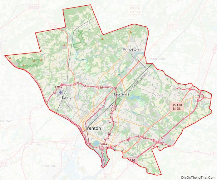
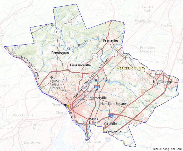
Mercer County Road Map
Geography
According to the 2010 Census, Mercer County had a total area of 228.89 square miles (592.8 km), including 224.56 square miles (581.6 km) of land (98.1%) and 4.33 square miles (11.2 km) of water (1.9%).
The county is generally flat and low-lying on the inner coastal plain with a few hills closer to the Delaware River. Baldpate Mountain, near Pennington, is the highest hill, at 480 feet (150 m) above sea level. The lowest point is at sea level along the Delaware River.
Climate
Most of Mercer has a hot-summer humid continental climate (Dfa) except for the southern portion of the county near and including Trenton where a humid subtropical climate (Cfa) exists. The hardiness zones are 6b and 7a.
Mercer County Topographic Map
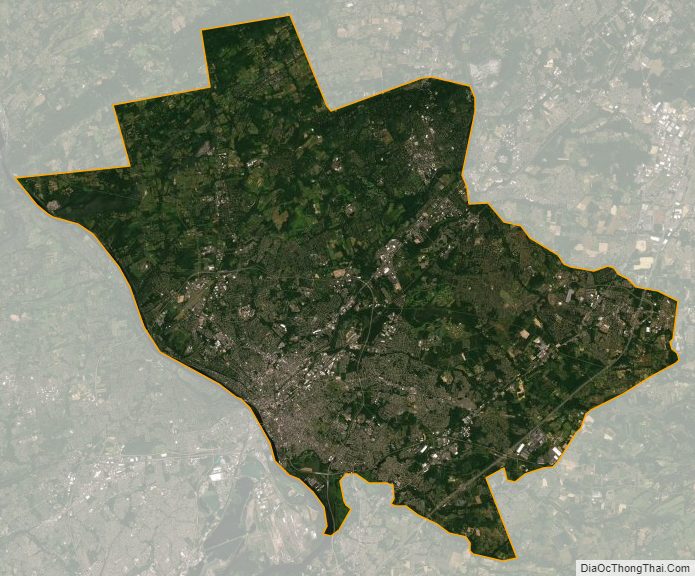
Mercer County Satellite Map
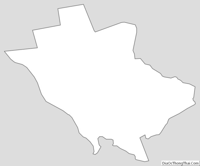
Mercer County Outline Map
See also
Map of New Jersey State and its subdivision: Map of other states:- Alabama
- Alaska
- Arizona
- Arkansas
- California
- Colorado
- Connecticut
- Delaware
- District of Columbia
- Florida
- Georgia
- Hawaii
- Idaho
- Illinois
- Indiana
- Iowa
- Kansas
- Kentucky
- Louisiana
- Maine
- Maryland
- Massachusetts
- Michigan
- Minnesota
- Mississippi
- Missouri
- Montana
- Nebraska
- Nevada
- New Hampshire
- New Jersey
- New Mexico
- New York
- North Carolina
- North Dakota
- Ohio
- Oklahoma
- Oregon
- Pennsylvania
- Rhode Island
- South Carolina
- South Dakota
- Tennessee
- Texas
- Utah
- Vermont
- Virginia
- Washington
- West Virginia
- Wisconsin
- Wyoming