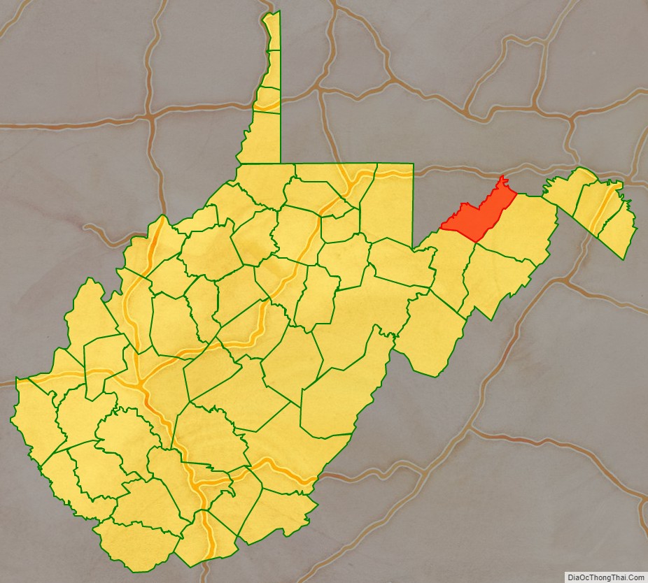
Mineral County is a county in the U.S. state of West Virginia. It is part of the Cumberland, MD-WV Metropolitan Statistical Area. As of the 2020 census, the population was 26,938. Its county seat is Keyser. The county was founded in 1866.
| Name: | Mineral County |
|---|---|
| FIPS code: | 54-057 |
| State: | West Virginia |
| Founded: | February 1, 1866 |
| Seat: | Keyser |
| Largest city: | Keyser |
| Total Area: | 329 sq mi (850 km²) |
| Land Area: | 328 sq mi (850 km²) |
| Total Population: | 26,938 |
| Population Density: | 82/sq mi (32/km²) |
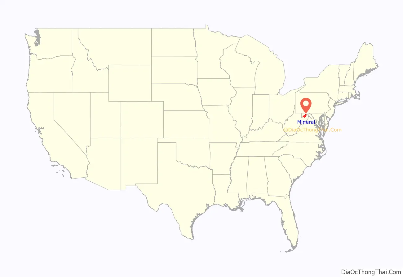
Mineral County location map. Where is Mineral County?
History
Ancient history
Indigenous peoples lived throughout the highlands along rivers in this area for thousands of years. Archeologists have identified artifacts of the Adena culture, dating from 1000 BC to 200 BC. They were among the several early Native American cultures who built major earthwork mounds for ceremonial and burial use. Remnants of their culture have been found throughout West Virginia. They were followed by other indigenous peoples.
With the growth of fur trading to the north after European encounter in the coastal areas, the nations of the Haudenosaunee (or Iroquois Confederacy), based in present-day New York, moved into the Ohio Valley in search of new hunting grounds. By the 17th century they had conquered other tribes, pushed them out to the west, and preserved the area for hunting.
1863 to present
It was not until after West Virginia became a state in 1863 that present-day Mineral County was organized. It was created in 1866 by an Act of the West Virginia Legislature from the existing Hampshire County. The name was selected due to its reserves of minerals, especially coal – although coal, a type of sedimentary rock, is not a mineral because it does not have a crystalline structure.
The seminal point in the creation of the county was the arrival of the main line of the Baltimore and Ohio Railroad in 1842. The county seat of Keyser was named for an executive of the railroad.
In 1863, West Virginia’s counties were divided into civil townships, with the intention of encouraging local government. This proved impractical in the heavily rural state, and in 1872 the townships were converted into magisterial districts. After its formation in 1866, Mineral County was divided into seven townships: Cabin Run, Elk, Frankfort, Mill Creek, New Creek, Piedmont, and Welton. Mill Creek Township was returned to Hampshire County in 1871, and in 1872 the six remaining townships became magisterial districts. Except for minor adjustments, they remained relatively unchanged until the 1980s, when they were consolidated into three new districts: District 1, District 2, and District 3.
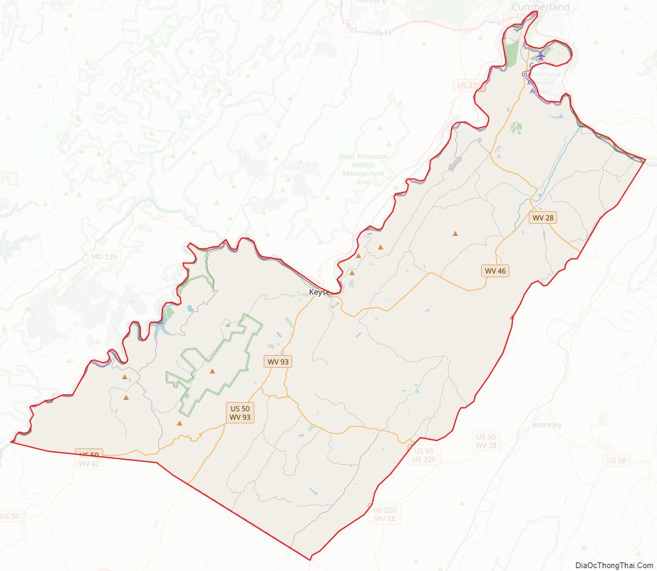
Mineral County Road Map
Geography
According to the United States Census Bureau, the county has a total area of 329 square miles (850 km), of which 328 square miles (850 km) is land and 1.4 square miles (3.6 km) (0.4%) is water.
Mountains
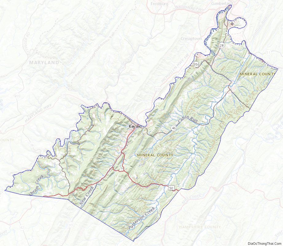
The northern terminus of the Allegheny Front in West Virginia lies in Mineral County and includes the highest point in the county. Known as “the Pinnacle”, it is 3,104 feet (946 m) above sea level. From the abandoned fire tower four states are visible, Pennsylvania, Maryland, West Virginia, and Virginia. The Allegheny Front is the largest mountain in the county; on the north end it is also known as Green Mountain. On top of the Allegheny Plateau is located the town of Elk Garden, West Virginia in the southwestern portion of the county. The Potomac River Valley lies to west and north of the mountain, and the New Creek Valley lies to the east.
Knobly Mountain lies between the New Creek and Patterson Creek valleys. It is the longest mountain in Mineral County stretching from the Grant County line in the south to the Potomac River in the north at Ridgeley, West Virginia.
To the east of the Patterson Creek Valley lie a series of low hills which form the eastern border of the county with Hampshire County.
Rivers
- North Branch Potomac River is the largest river, though not actually in the county. It forms the northern border of the county and the state border with actual border being the low water mark on the south side. Jennings Randolph Lake is located on this stream.
- New Creek enters the North Branch Potomac River at Keyser with the headwaters starting at Dam Site 14 in Grant County, West Virginia. It is the water supply for the city of Keyser.
- Patterson Creek enters the Potomac River east of Cumberland, Maryland with headwaters being in Grant County, West Virginia. The Patterson Creek watershed contains two-thirds of Mineral County.
Minerals
Natural gas is found east of the Allegheny Front as well as iron ore deposits. The county no longer produces iron, but several abandoned iron furnaces from the 19th century still exist.
Mineral County Topographic Map
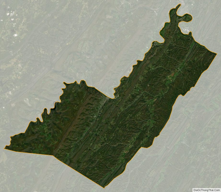
Mineral County Satellite Map
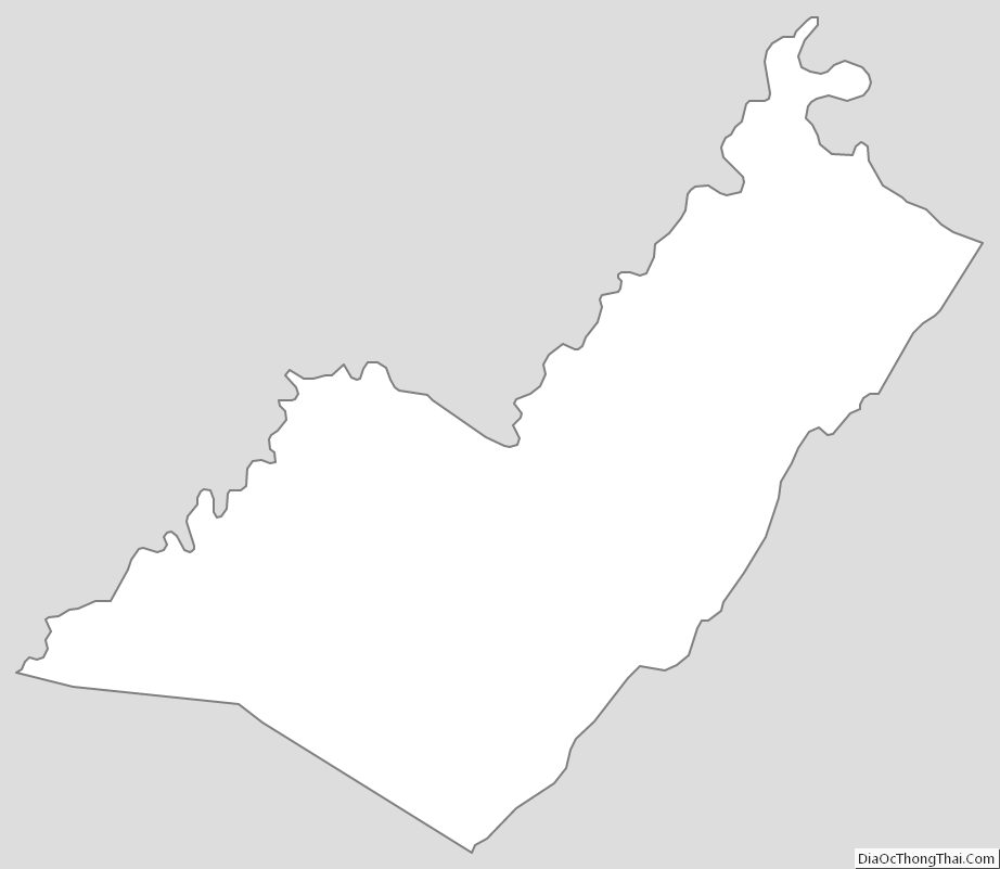
Mineral County Outline Map
See also
Map of West Virginia State and its subdivision:- Barbour
- Berkeley
- Boone
- Braxton
- Brooke
- Cabell
- Calhoun
- Clay
- Doddridge
- Fayette
- Gilmer
- Grant
- Greenbrier
- Hampshire
- Hancock
- Hardy
- Harrison
- Jackson
- Jefferson
- Kanawha
- Lewis
- Lincoln
- Logan
- Marion
- Marshall
- Mason
- McDowell
- Mercer
- Mineral
- Mingo
- Monongalia
- Monroe
- Morgan
- Nicholas
- Ohio
- Pendleton
- Pleasants
- Pocahontas
- Preston
- Putnam
- Raleigh
- Randolph
- Ritchie
- Roane
- Summers
- Taylor
- Tucker
- Tyler
- Upshur
- Wayne
- Webster
- Wetzel
- Wirt
- Wood
- Wyoming
- Alabama
- Alaska
- Arizona
- Arkansas
- California
- Colorado
- Connecticut
- Delaware
- District of Columbia
- Florida
- Georgia
- Hawaii
- Idaho
- Illinois
- Indiana
- Iowa
- Kansas
- Kentucky
- Louisiana
- Maine
- Maryland
- Massachusetts
- Michigan
- Minnesota
- Mississippi
- Missouri
- Montana
- Nebraska
- Nevada
- New Hampshire
- New Jersey
- New Mexico
- New York
- North Carolina
- North Dakota
- Ohio
- Oklahoma
- Oregon
- Pennsylvania
- Rhode Island
- South Carolina
- South Dakota
- Tennessee
- Texas
- Utah
- Vermont
- Virginia
- Washington
- West Virginia
- Wisconsin
- Wyoming