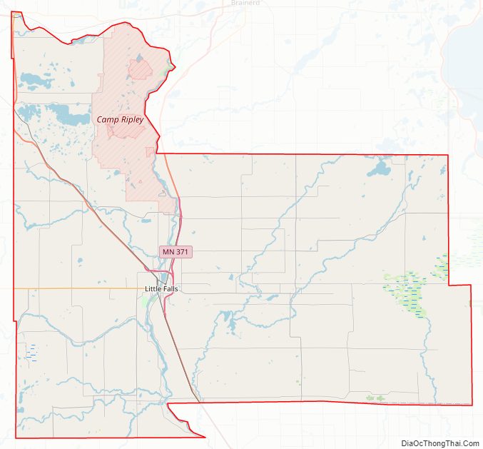
Morrison County is a county in the U.S. state of Minnesota. As of the 2020 census, the population was 34,010. Its county seat is Little Falls. Camp Ripley Military Reservation occupies a significant area in north-central Morrison County.
| Name: | Morrison County |
|---|---|
| FIPS code: | 27-097 |
| State: | Minnesota |
| Founded: | February 25, 1856 |
| Named for: | William and Allan Morrison |
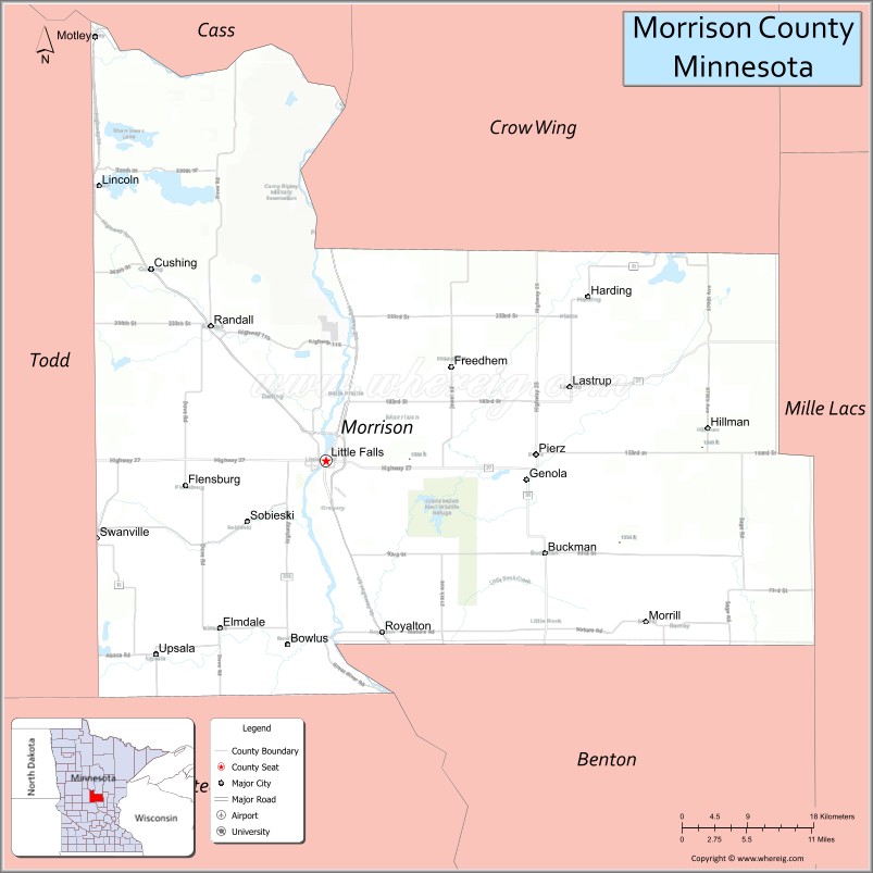
| Seat: | Little Falls |
| Largest city: | Little Falls |
| Total Area: | 1,153 sq mi (2,990 km²) |
| Land Area: | 1,125 sq mi (2,910 km²) |
| Total Population: | 34,010 |
| Population Density: | 29/sq mi (11/km²) |
| Time zone: | UTC−6 (Central) |
| Summer Time Zone (DST): | UTC−5 (CDT) |
| Website: | www.co.morrison.mn.us |
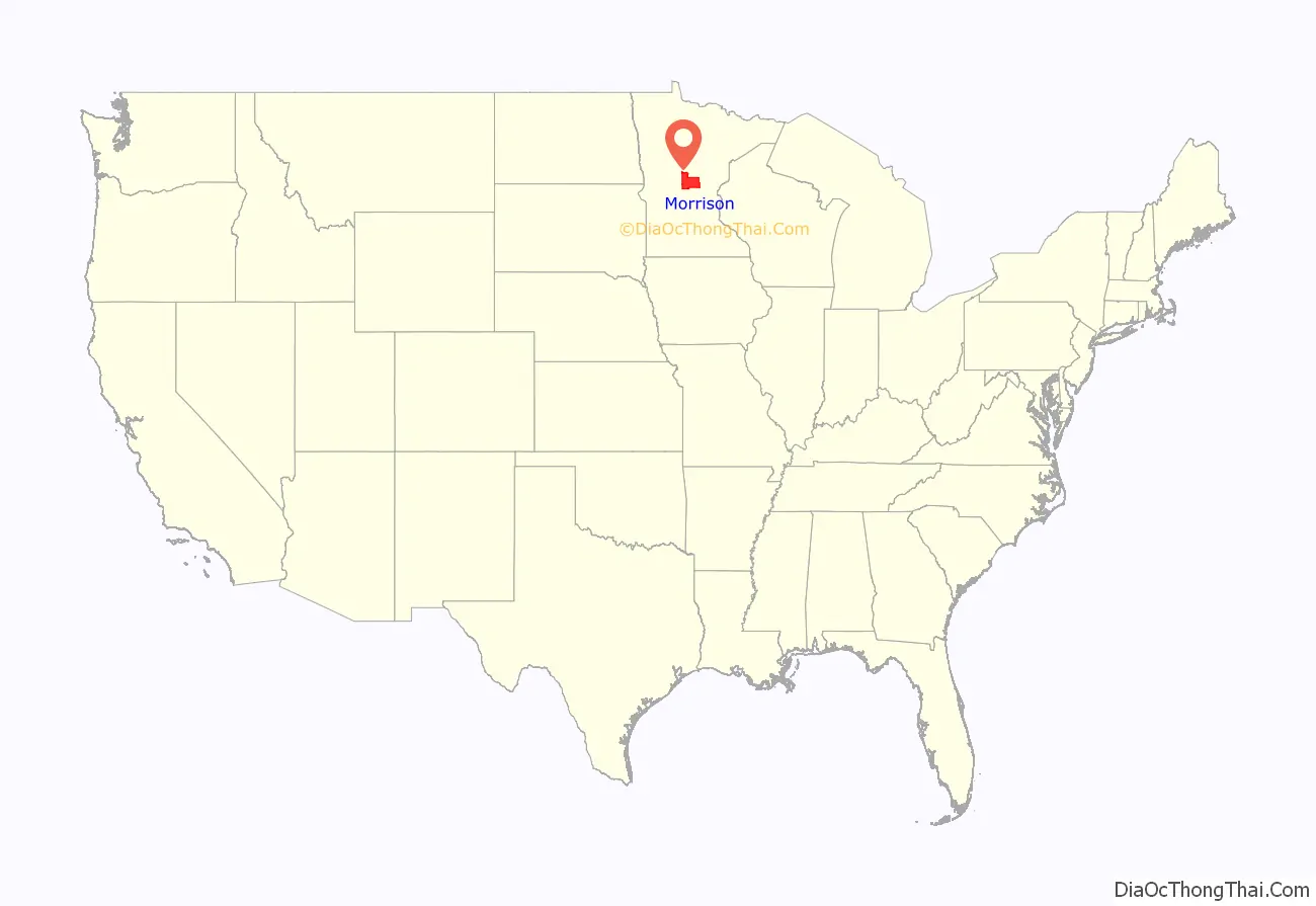
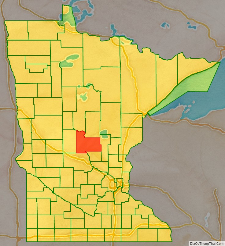
Morrison County location map. Where is Morrison County?
History
Dakotah and Ojibwe Indians lived in central Minnesota around the Mississippi River. French and English fur traders and voyageurs traveled through Minnesota from the 17th century to the 19th century. They used the river to transport their goods and trade with the natives. The county was named for fur trading brothers William and Allan Morrison.
In the 19th century three prominent explorers led expeditions along the river through the area that became Morrison County. Zebulon Pike came through in 1805. Michigan Territory Governor Lewis Cass led an expedition through the area in 1820. Explorer and scientist Joseph Nicollet created the first accurate map of the area along the river in 1836.
Missionaries were some of the area’s first European settlers. Methodist missionaries settled temporarily along the Little Elk River in 1838. The Reverend Frederic and Elisabeth (Taylor) Ayer moved to the Belle Prairie area in 1849. They started a mission and school there for the Ojibwe. Father Francis Xavier Pierz came to the area in 1852 and started many communities in central Minnesota, including Sobieski and Rich Prairie (later renamed Pierz) in Morrison County.
The US legislature established the Wisconsin Territory effective July 3, 1836. It existed until its eastern portion was granted statehood (as Wisconsin) in 1848. The federal government set up the Minnesota Territory effective March 3, 1849. The newly organized territorial legislature created nine counties across the territory in October of that year. On 25 February 1856, Benton, one of those original counties, had a portion of its northern section partitioned off to create Morrison County, with Little Falls as the county seat. It was named for William and Allen Morrison, early fur trappers and traders in the area.
The event that prodded further development of the county was the building of Fort Ripley (originally named Ft. Gaines). In order to construct this military outpost, the Little Falls Mill and Land Company built a dam and sawmill in 1849. The company was formed by James Green, Allan Morrison, Henry Rice, John Irvine, John Blair Smith Todd, and Napoleon Jackson Tecumseh Dana. Fort Ripley was ostensibly built to protect the Winnebago Indians, who had been relocated by Henry Rice from Iowa to central Minnesota west of the Mississippi River, between the Crow Wing and Long Prairie rivers. Rice hoped the Winnebago would act as a buffer between the warring Ojibwe and Dakotah. His plan was unsuccessful and in 1855 the Winnebago were moved to the Blue Earth River in southern Minnesota.
The Little Falls area was first settled in 1848, and platted in 1855. Its growth occurred when the Little Falls Company (later called the Little Falls Manufacturing Company) built a second dam. This dam washed out, as had the first, and Little Falls entered a long period of economic depression and stagnant population. Bit by bit, Little Falls grew, until it was officially incorporated as a village in 1879.
Another wave of immigration occurred between 1880 and 1920. A wide variety of ethnic groups settled in Morrison County. This wave of immigration was spurred by the construction of the third dam at Little Falls in 1887. A group of investors from Louisville, Kentucky led by M. M. Williams financed the dam. To be sure their investment would succeed, they encouraged other major industries to move to the city, touting the water power.
Pine Tree Lumber Company, run by Charles A. Weyerhaeuser and Richard “Drew” Musser, was one business that took advantage of the water power, with their operations in Little Falls beginning in 1890. Hennepin Paper Company also started operations that year in the city.
In 1889 the Louisville investors drew up a charter to transform Little Falls from a village to a city. Nathan Richardson, one of Morrison County’s original organizers, became the city’s first mayor.
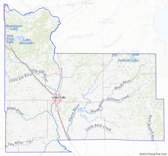
Morrison County Road Map
Geography
The Mississippi River flows south through west-central Morrison County. The Platte River flows south-southwest through the central part of the county, discharging into the Mississippi just at both rivers exit Morrison County at the border with Stearns County. The Little Elk River rises in Morrison County and flows east to discharge into the Mississippi just north of Little Falls, picking up the flow of the South Branch of the Little Elk River at Randall. The Mississippi also receives the flow of the Nokasippi River just above Camp Ripley. The Skunk River rises in the northeast part of the county, and flows west-southwest through the lower central part of the county, discharging into the Platte southeast of Little Falls.
The terrain consists of low rolling hills, partly wooded, carved with drainages and gullies, and with all available area devoted to agriculture. It generally slopes to the south, and slopes to the river valley from both east and west borders, with its highest point on the Camp Ripley Military Reservation, 2.4 miles (3.9 km) east and 1.4 mile (2.2 km) north of the east end of Lake Alexander, at 1,521′ (463m) ASL. The county has an area of 1,153 square miles (2,990 km), of which 1,125 square miles (2,910 km) is land and 28 square miles (73 km) (2.5%) is water.
Major highways
- U.S. Highway 10
- Minnesota State Highway 25
- Minnesota State Highway 27
- Minnesota State Highway 28
- Minnesota State Highway 115
- Minnesota State Highway 238
- Minnesota State Highway 371
Airports
- Little Falls/Morrison County Airport (LXL) – southeast of Little Falls
Adjacent counties
- Cass County – north
- Crow Wing County – northeast
- Mille Lacs County – east
- Benton County – southeast
- Stearns County – south
- Todd County – west
Protected areas
- Belle Prairie County Park
- Charles A. Lindbergh State Park
- Coon Lake State Wildlife Management Area
- Crane Meadows National Wildlife Refuge
- Crane Meadows State Wildlife Management Area
- Crow Wing State Park (part)
- Culdrum State Wildlife Management Area
- Ereaua State Wildlife Management Area
- Lake Alexander Woods Scientific and Natural Area
- Little Elk State Wildlife Management Area
- Mud Lake State Wildlife Management Area
- Neitermeier State Wildlife Management Area
- Popple Lake State Wildlife Management Area
- Rice-Skunk Lake State Wildlife Management Area
- Richardson State Wildlife Management Area
- Ripley Esker Scientific and Natural Area
- Sponsa State Wildlife Management Area
- Wittiker State Wildlife Management Area
Morrison County Topographic Map
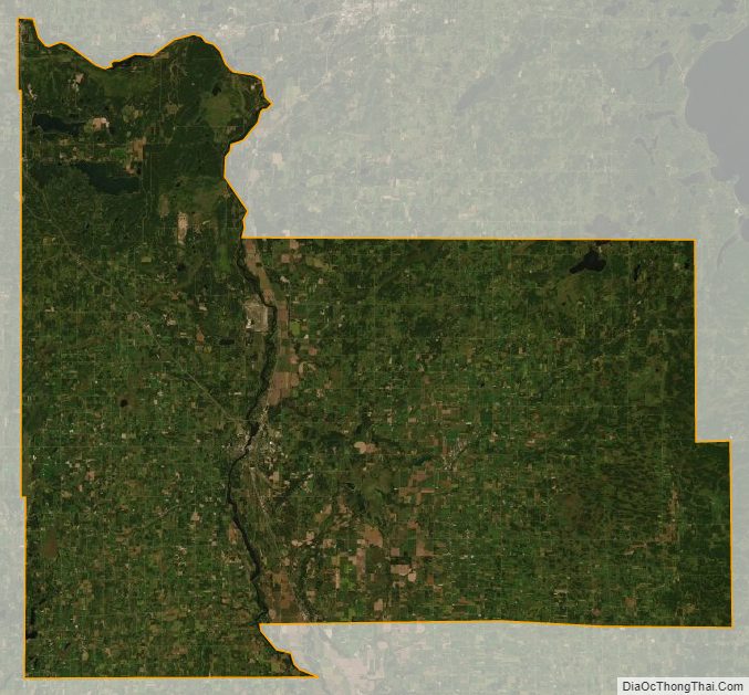
Morrison County Satellite Map
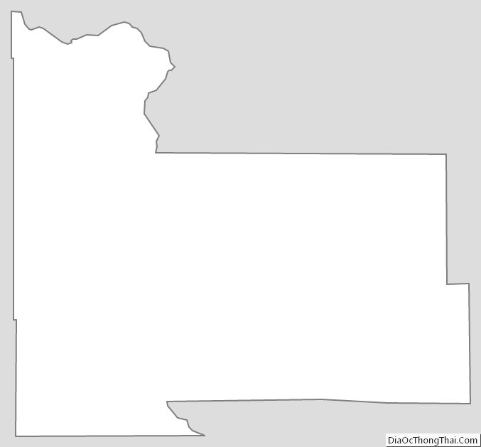
Morrison County Outline Map
See also
Map of Minnesota State and its subdivision:- Aitkin
- Anoka
- Becker
- Beltrami
- Benton
- Big Stone
- Blue Earth
- Brown
- Carlton
- Carver
- Cass
- Chippewa
- Chisago
- Clay
- Clearwater
- Cook
- Cottonwood
- Crow Wing
- Dakota
- Dodge
- Douglas
- Faribault
- Fillmore
- Freeborn
- Goodhue
- Grant
- Hennepin
- Houston
- Hubbard
- Isanti
- Itasca
- Jackson
- Kanabec
- Kandiyohi
- Kittson
- Koochiching
- Lac qui Parle
- Lake
- Lake of the Woods
- Lake Superior
- Le Sueur
- Lincoln
- Lyon
- Mahnomen
- Marshall
- Martin
- McLeod
- Meeker
- Mille Lacs
- Morrison
- Mower
- Murray
- Nicollet
- Nobles
- Norman
- Olmsted
- Otter Tail
- Pennington
- Pine
- Pipestone
- Polk
- Pope
- Ramsey
- Red Lake
- Redwood
- Renville
- Rice
- Rock
- Roseau
- Saint Louis
- Scott
- Sherburne
- Sibley
- Stearns
- Steele
- Stevens
- Swift
- Todd
- Traverse
- Wabasha
- Wadena
- Waseca
- Washington
- Watonwan
- Wilkin
- Winona
- Wright
- Yellow Medicine
- Alabama
- Alaska
- Arizona
- Arkansas
- California
- Colorado
- Connecticut
- Delaware
- District of Columbia
- Florida
- Georgia
- Hawaii
- Idaho
- Illinois
- Indiana
- Iowa
- Kansas
- Kentucky
- Louisiana
- Maine
- Maryland
- Massachusetts
- Michigan
- Minnesota
- Mississippi
- Missouri
- Montana
- Nebraska
- Nevada
- New Hampshire
- New Jersey
- New Mexico
- New York
- North Carolina
- North Dakota
- Ohio
- Oklahoma
- Oregon
- Pennsylvania
- Rhode Island
- South Carolina
- South Dakota
- Tennessee
- Texas
- Utah
- Vermont
- Virginia
- Washington
- West Virginia
- Wisconsin
- Wyoming