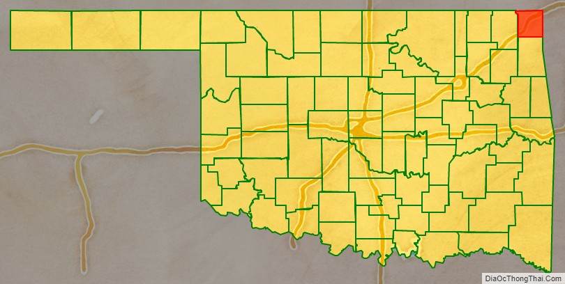
Ottawa County is a county located in the northeastern corner of the U.S. state of Oklahoma. As of the 2020 census, the population was 30,285. Its county seat is Miami. The county was named for the Ottawa Tribe of Oklahoma. It is also the location of the federally recognized Modoc Nation and the Quapaw Nation, which is based in Quapaw.
Ottawa County comprises the Miami, OK Micropolitan Statistical Area, which is included in the Joplin-Miami, MO-OK Combined Statistical Area. The county borders both Kansas and Missouri.
The county was an important lead and zinc mining region during the early 1900s, and in 1983 the Tar Creek Superfund site was inaugurated to clean up tailings and prevent groundwater and waterway contamination with leachates.
| Name: | Ottawa County |
|---|---|
| FIPS code: | 40-115 |
| State: | Oklahoma |
| Founded: | 1907 |
| Named for: | Ottawa Tribe of Oklahoma |
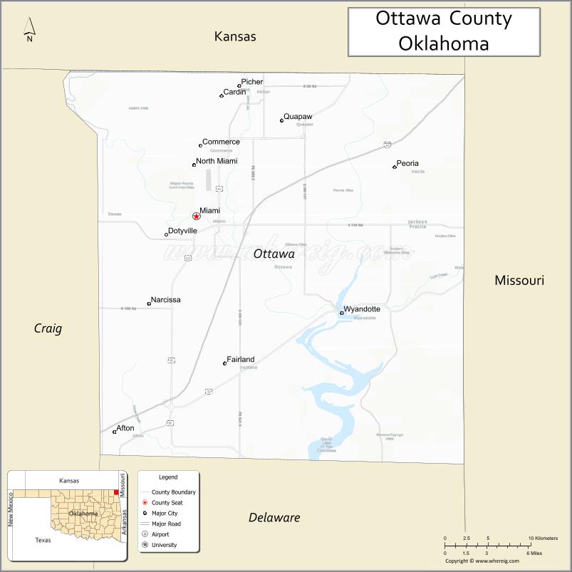
| Seat: | Miami |
| Largest city: | Miami |
| Total Area: | 485 sq mi (1,260 km²) |
| Land Area: | 471 sq mi (1,220 km²) |
| Total Population: | 30,285 |
| Population Density: | 68/sq mi (26/km²) |
| Website: | ottawa.okcounties.org |
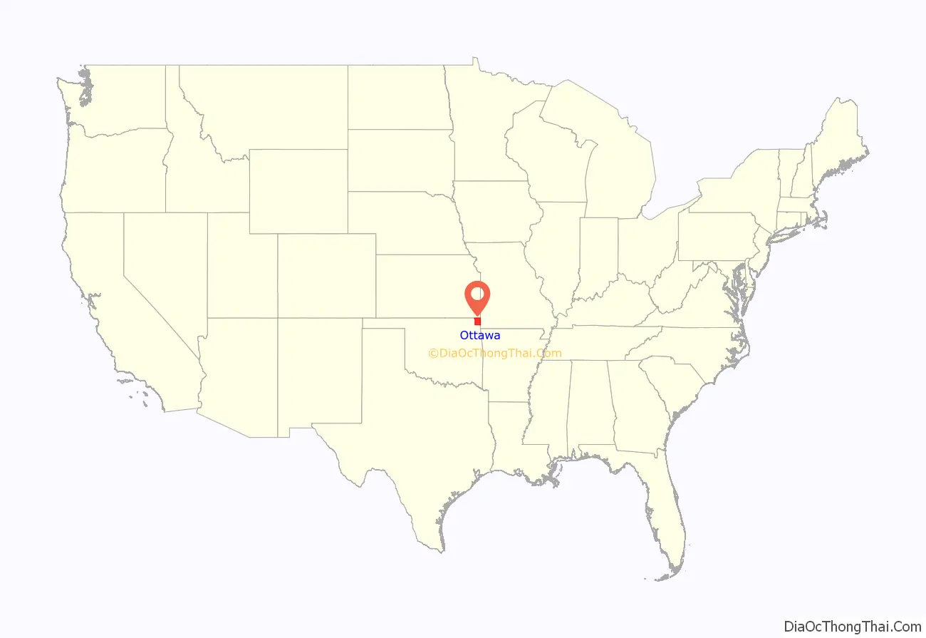
Ottawa County location map. Where is Ottawa County?
History
Archaeological studies indicate this area was inhabited for thousands of years by succeeding cultures of prehistoric indigenous peoples. According to the Encyclopedia of Oklahoma History & Culture, at the start of the 20th century, there were eight known Archaic sites (6000 B. C. to 1 A. D.), sixteen Woodland sites (1 A. D. to 1000 A.D.), and six Plains Village sites (1000 to 1500 A. D.).
The Osage Nation had moved into the area from Missouri and Kansas by the 19th century, under pressure from European-American encroachment on their lands. They ceded this land to the Federal Government in exchange for another area farther west in Indian Territory. In 1828, the Western Cherokee, the first group of this nation to relocate west of the Mississippi River, ceded their land in Western Arkansas to the Federal Government in exchange for some of the land just vacated by the Osage.
In 1831, the Federal Government reacquired part of what would eventually become Ottawa County in order to resettle some smaller tribes that had been forced west from the Midwest under its Indian Removal program. These included two tribes of Iroquois, Shawnee, Quapaw, Peoria, Kaskaskia, Miami, Ottawa and Wyandotte. The Neosho Agency administered the affairs of these tribes from 1837 until 1871. In that year, it was renamed as the Quapaw Agency, serving only the tribes in Indian Territory.
The Modoc band led by Captain Jack in northern California was exiled and relocated here in 1873, after being taken as prisoner following their defeat in the Modoc War. The 153 members were settled at the Quapaw Agency. After regaining federally recognized status in 1978 as the Modoc Tribe of Oklahoma, they were given land of their own under federal trust in this county. Native Americans make up nearly 17% of the population in the county.
This county is part of the Tri-state District, a center of lead and zinc mining through the first half of the 20th century. Unrestricted mining resulted in severe environmental degradation and mining centers such as Picher, Oklahoma in the county were included within the Tar Creek Superfund Site in 1980. Environmental remediation has been conducted, but the state and federal government have also closed Picher as a city and relocated nearly all its residents since the early 21st century. In 1996 the government found that 34% of the children of Picher, OK had lead poisoning due to groundwater, air and dust effects.
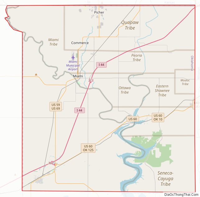
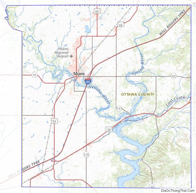
Ottawa County Road Map
Geography
According to the U.S. Census Bureau, the county has a total area of 485 square miles (1,260 km), of which 471 square miles (1,220 km) is land and 14 square miles (36 km) (2.8%) is water. It is the fourth-smallest county in Oklahoma by area. The eastern part of the county lies in the Ozark Plains, while the western is in the Neosho Lowlands.
Adjacent counties
- Cherokee County, Kansas (north)
- Newton County, Missouri (east)
- McDonald County, Missouri (southeast)
- Delaware County (south)
- Craig County (west)
Ottawa County Topographic Map
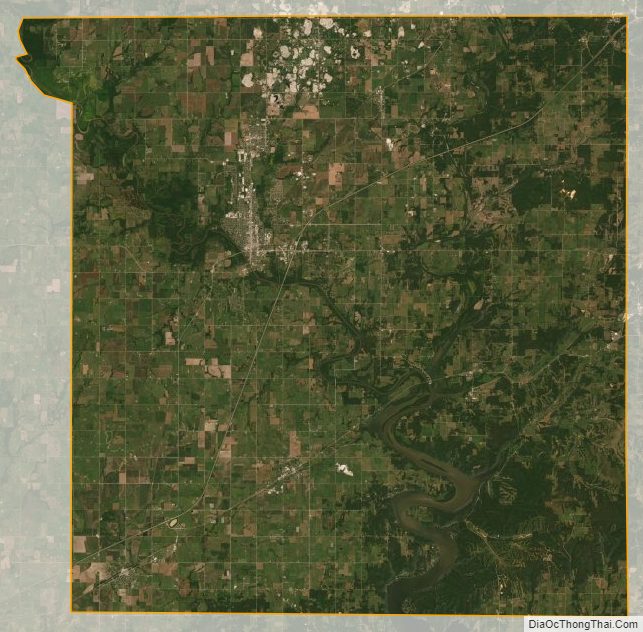
Ottawa County Satellite Map
Ottawa County Outline Map

See also
Map of Oklahoma State and its subdivision:- Adair
- Alfalfa
- Atoka
- Beaver
- Beckham
- Blaine
- Bryan
- Caddo
- Canadian
- Carter
- Cherokee
- Choctaw
- Cimarron
- Cleveland
- Coal
- Comanche
- Cotton
- Craig
- Creek
- Custer
- Delaware
- Dewey
- Ellis
- Garfield
- Garvin
- Grady
- Grant
- Greer
- Harmon
- Harper
- Haskell
- Hughes
- Jackson
- Jefferson
- Johnston
- Kay
- Kingfisher
- Kiowa
- Latimer
- Le Flore
- Lincoln
- Logan
- Love
- Major
- Marshall
- Mayes
- McClain
- McCurtain
- McIntosh
- Murray
- Muskogee
- Noble
- Nowata
- Okfuskee
- Oklahoma
- Okmulgee
- Osage
- Ottawa
- Pawnee
- Payne
- Pittsburg
- Pontotoc
- Pottawatomie
- Pushmataha
- Roger Mills
- Rogers
- Seminole
- Sequoyah
- Stephens
- Texas
- Tillman
- Tulsa
- Wagoner
- Washington
- Washita
- Woods
- Woodward
- Alabama
- Alaska
- Arizona
- Arkansas
- California
- Colorado
- Connecticut
- Delaware
- District of Columbia
- Florida
- Georgia
- Hawaii
- Idaho
- Illinois
- Indiana
- Iowa
- Kansas
- Kentucky
- Louisiana
- Maine
- Maryland
- Massachusetts
- Michigan
- Minnesota
- Mississippi
- Missouri
- Montana
- Nebraska
- Nevada
- New Hampshire
- New Jersey
- New Mexico
- New York
- North Carolina
- North Dakota
- Ohio
- Oklahoma
- Oregon
- Pennsylvania
- Rhode Island
- South Carolina
- South Dakota
- Tennessee
- Texas
- Utah
- Vermont
- Virginia
- Washington
- West Virginia
- Wisconsin
- Wyoming