Otter Tail County is a county in the U.S. state of Minnesota. As of the 2020 census, its population was 60,081. Its county seat is Fergus Falls. Otter Tail County comprises the Fergus Falls micropolitan statistical area. With 1,048 lakes in its borders, Otter Tail County has more lakes than any other county in the United States.
| Name: | Otter Tail County |
|---|---|
| FIPS code: | 27-111 |
| State: | Minnesota |
| Founded: | 1858 |
| Named for: | Otter Tail Lake and Otter Tail River |
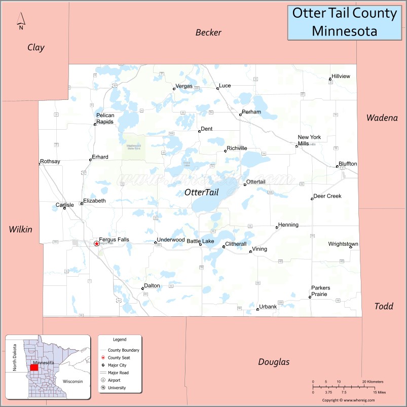
| Seat: | Fergus Falls |
| Largest city: | Fergus Falls |
| Total Area: | 2,225 sq mi (5,760 km²) |
| Land Area: | 1,972 sq mi (5,110 km²) |
| Total Population: | 60,081 |
| Population Density: | 30.5/sq mi (11.8/km²) |
| Time zone: | UTC−6 (Central) |
| Summer Time Zone (DST): | UTC−5 (CDT) |
| Website: | ottertailcountymn.us |
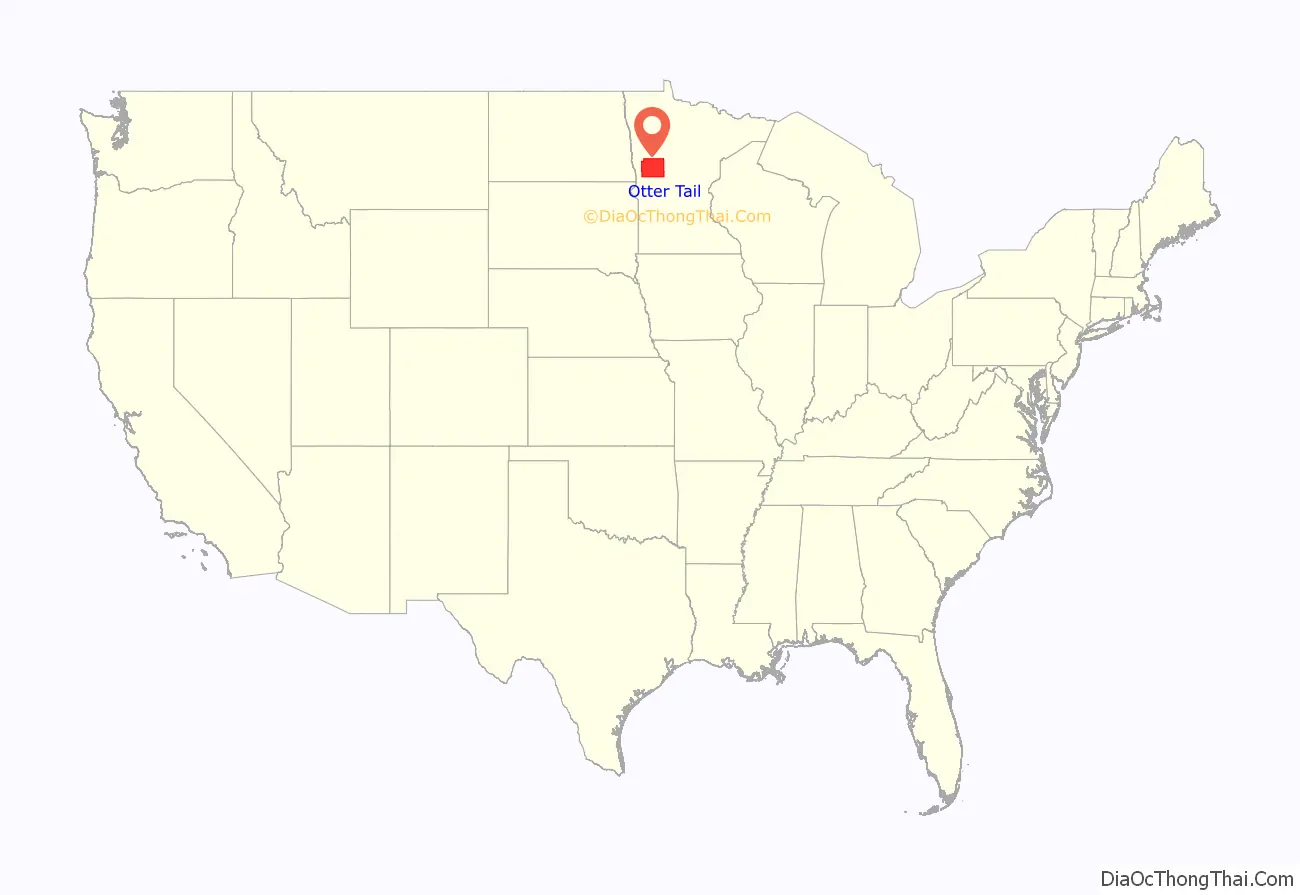
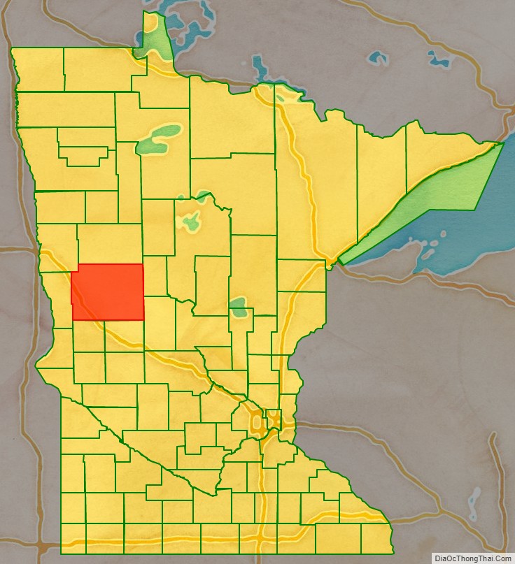
Otter Tail County location map. Where is Otter Tail County?
History
Native Americans used the area for hunting and fishing, and had permanent dwelling sites. Two Native American tribes were in constant conflict. The Dakota (Sioux) were being pushed from their home area by the Ojibwa (Chippewa) during the late 18th and early 19th centuries. Burial mounds and artifacts can still be found. Some of the oldest Native American remains were found near Pelican Rapids, Minnesota. The remains, nicknamed Minnesota Girl, were dated at about 11,000 BC.
The first white men to enter the county were French and British fur traders. Efforts were made to set up trading posts on the Leaf Lakes and Otter Tail Lake. In the late 19th century, most of the towns were built along the railroad lines. Lumber and agriculture were the major industries in the county at that time. The pine and hardwood forests, transportation system, and markets were instrumental in the development of Fergus Falls into a lumber center. The Wisconsin Territory was established by the federal government effective July 3, 1836, and existed until its eastern portion was granted statehood (as Wisconsin) in 1848. The federal government set up the Minnesota Territory effective March 3, 1849. The newly organized territorial legislature created nine counties across the territory in October of that year. One of those original counties, Dakota, had a section partitioned off in 1851 to create Cass County. On March 18, 1858, the outgoing territorial legislature created Otter Tail County from areas partitioned from Cass and Pembina, another of the original counties created in 1849. The county was named for Otter Tail Lake and the Otter Tail River. The county was not organized in 1858, nor was a county seat specified. On September 12, 1868, the legislature completed the county organization, and specified Otter Tail City as county seat.
Otter Tail City began as a waystation on a fur-trade route between Saint Paul and the Red River valley. The settlement was of sufficient size that when the Minnesota Territory established a US land office for this part of the territory, the office was sited at Otter Tail City. Thus, the city was named as the seat when the county was organized, but people had begun settling the future Fergus Falls area in 1857, and it grew sufficiently that in fall 1872, the vote was taken to move the county seat there. The Northern Pacific Railroad had initially planned to run a line through Otter Tail City, but complications caused the line to be placed in Fergus Falls, which precipitated the county seat move. The Soo Line later made plans to run a line through Otter Tail City, but when townspeople could not agree on the routing, another route east of the city was constructed. Thus, a new city plat was generated, with the settlement name changing to Ottertail.
In 1870, the population of the county was about 2,000. At that time, the principal languages spoken in the county were Norwegian, Swedish, German, and English.
The people of Fergus Falls organized a new county named Holcomb. In 1872, a legislative act abolished Holcomb County, added additional townships to the west, and established Fergus Falls as Otter Tail County’s seat.
Early telephone
The Fergus Falls Telephone Exchange Company organized on March 20, 1882, and was in a room at the First National Bank at the corner of Cascade and Lincoln. The system install was very crude. Efforts were made to have telephones installed in the courthouse but commissioners did not feel it was necessary. Eventually a telephone was installed in the auditor’s office through a combination of private and public funds. A clerk in the office was tasked with tracking down the officer who was called. The business was sold to the Northwestern Telephone Exchange Company in 1883.
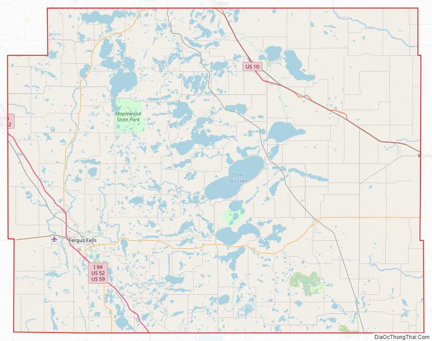
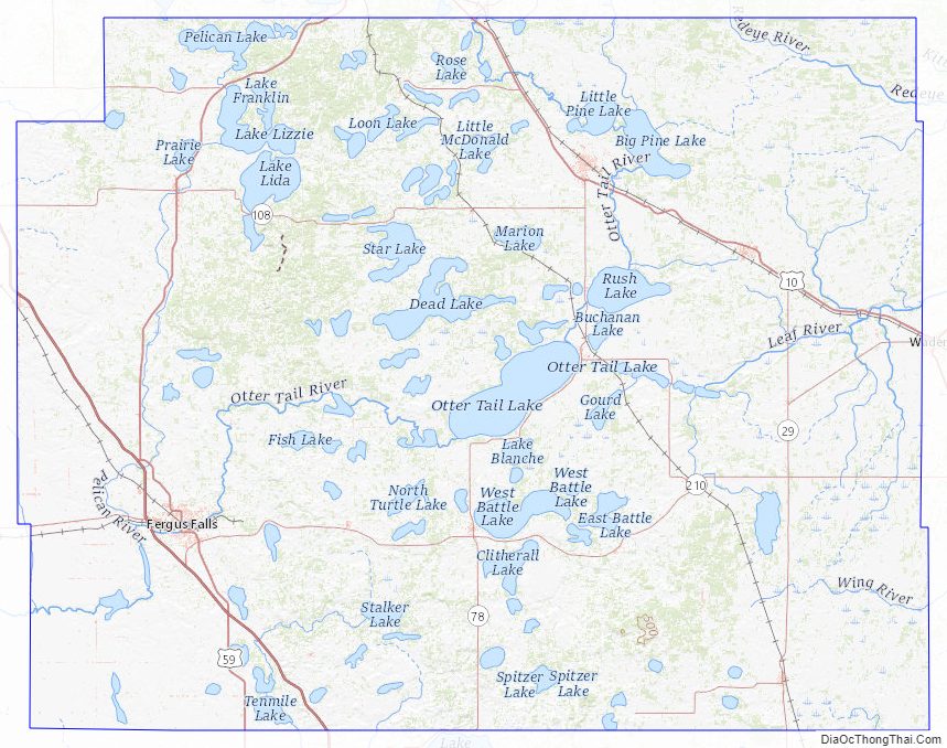
Otter Tail County Road Map
Geography
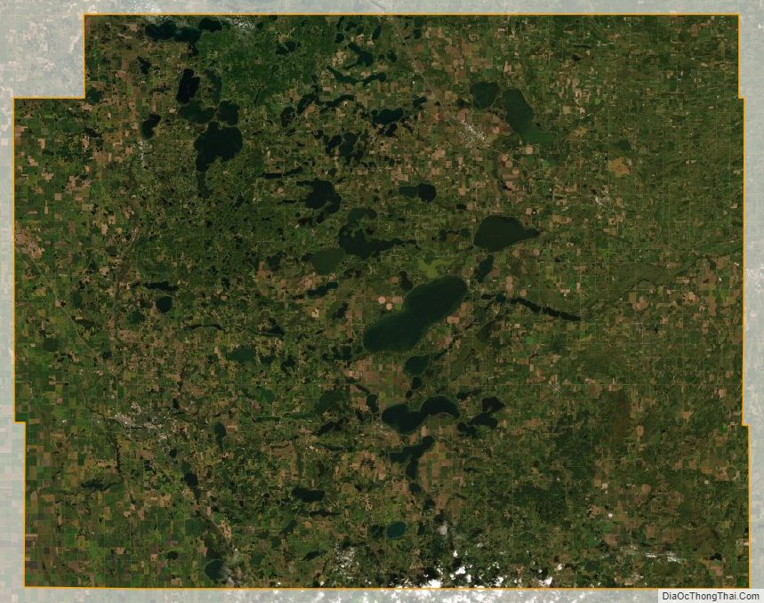
The Otter Tail River flows south and west through the central and western parts of the county on its way to form the Red River in Wilkin County. It is joined by the south-flowing Pelican River west of Fergus Falls. The Leaf River rises in the county and flows east to its confluence with the Crow Wing River in neighboring Wadena County. The Redeye River flows southeast through the county’s northeast section toward its confluence with the Leaf in Wadena. The county terrain consists of rolling hills, heavily wooded through its center section, dotted with lakes and ponds, and carved with drainages and gullies. The available area is devoted to agriculture. The county terrain slopes to the west and south. The highest points on the county terrain are at two different locations: Inspiration Peak, at 1,727 ft (526 m), and Pekan Peak (unofficial name) a summit northeast of the village of Urbank in Folden Township, Section 32, at 1,800 ft (549 m) above sea level. The county has an area of 2,225 square miles (5,760 km), of which 1,972 square miles (5,110 km) are land and 252 square miles (650 km) (11%) are covered by water. Otter Tail is one of 17 Minnesota savanna region counties with more savanna soils than either forest or prairie soils. According to its website, the county contains over 1,000 lakes.
Otter Tail County Topographic Map
Otter Tail County Satellite Map
Otter Tail County Outline Map

See also
Map of Minnesota State and its subdivision:- Aitkin
- Anoka
- Becker
- Beltrami
- Benton
- Big Stone
- Blue Earth
- Brown
- Carlton
- Carver
- Cass
- Chippewa
- Chisago
- Clay
- Clearwater
- Cook
- Cottonwood
- Crow Wing
- Dakota
- Dodge
- Douglas
- Faribault
- Fillmore
- Freeborn
- Goodhue
- Grant
- Hennepin
- Houston
- Hubbard
- Isanti
- Itasca
- Jackson
- Kanabec
- Kandiyohi
- Kittson
- Koochiching
- Lac qui Parle
- Lake
- Lake of the Woods
- Lake Superior
- Le Sueur
- Lincoln
- Lyon
- Mahnomen
- Marshall
- Martin
- McLeod
- Meeker
- Mille Lacs
- Morrison
- Mower
- Murray
- Nicollet
- Nobles
- Norman
- Olmsted
- Otter Tail
- Pennington
- Pine
- Pipestone
- Polk
- Pope
- Ramsey
- Red Lake
- Redwood
- Renville
- Rice
- Rock
- Roseau
- Saint Louis
- Scott
- Sherburne
- Sibley
- Stearns
- Steele
- Stevens
- Swift
- Todd
- Traverse
- Wabasha
- Wadena
- Waseca
- Washington
- Watonwan
- Wilkin
- Winona
- Wright
- Yellow Medicine
- Alabama
- Alaska
- Arizona
- Arkansas
- California
- Colorado
- Connecticut
- Delaware
- District of Columbia
- Florida
- Georgia
- Hawaii
- Idaho
- Illinois
- Indiana
- Iowa
- Kansas
- Kentucky
- Louisiana
- Maine
- Maryland
- Massachusetts
- Michigan
- Minnesota
- Mississippi
- Missouri
- Montana
- Nebraska
- Nevada
- New Hampshire
- New Jersey
- New Mexico
- New York
- North Carolina
- North Dakota
- Ohio
- Oklahoma
- Oregon
- Pennsylvania
- Rhode Island
- South Carolina
- South Dakota
- Tennessee
- Texas
- Utah
- Vermont
- Virginia
- Washington
- West Virginia
- Wisconsin
- Wyoming