Palo Pinto County is a county located in the U.S. state of Texas. As of the 2020 census, its population was 28,409. The county seat is Palo Pinto. The county was created in 1856 and organized the following year.
Palo Pinto County comprises the Mineral Wells micropolitan statistical area, which is part of the Dallas–Fort Worth combined statistical area. It is located in the western Cross Timbers ecoregion.
| Name: | Palo Pinto County |
|---|---|
| FIPS code: | 48-363 |
| State: | Texas |
| Founded: | 1857 |
| Named for: | Palo Pinto Creek |
| Seat: | Palo Pinto |
| Largest city: | Mineral Wells |
| Total Area: | 986 sq mi (2,550 km²) |
| Land Area: | 952 sq mi (2,470 km²) |
| Total Population: | 28,409 |
| Population Density: | 29/sq mi (11/km²) |
| Time zone: | UTC−6 (Central) |
| Summer Time Zone (DST): | UTC−5 (CDT) |
| Website: | www.co.palo-pinto.tx.us |
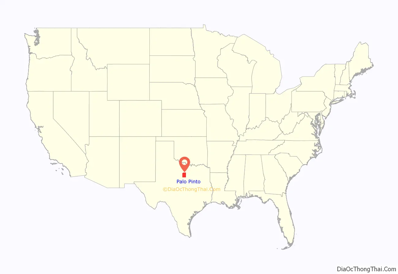
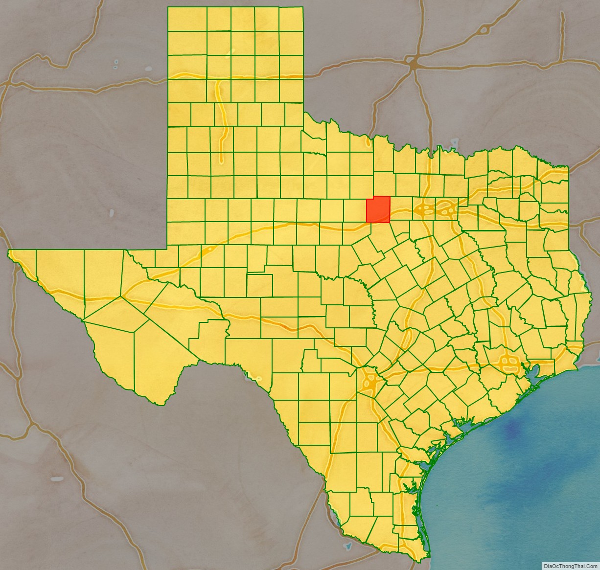
Palo Pinto County location map. Where is Palo Pinto County?
History
Native Americans
The Brazos Indian Reservation, founded by General Randolph B. Marcy in 1854, provided a safety area from warring Comanche for Delaware, Shawnee, Tonkawa, Wichita, Choctaw, and Caddo. Within the reservation, each tribe had its own village and cultivated agricultural crops. Government-contracted beef cattle were delivered each week. Citizens were unable to distinguish between reservation and nonreservation tribes, blaming Comanche and Kiowa depredations on the reservation Indians. A newspaper in Jacksboro, Texas, titled The White Man advocated removal of all tribes from North Texas.
During December 1858, Choctaw Tom, who was a Yowani married to a Hasinai woman, who was at times an interpreter to Sam Houston, and a group of reservation Indians received permission for an off-the-reservation hunt. On December 27, Captain Peter Garland and a vigilante group charged Choctaw Tom’s camp, indiscriminately murdering and injuring women and children along with the men. .
Governor Hardin Richard Runnels ordered John Henry Brown to the area with 100 troops. An examining trial was conducted about the Choctaw Tom raid, but no indictments resulted.
In May 1859, John Baylor and a number of whites confronted United States troops at the reservation, demanding the surrender of certain tribal individuals. The military balked, and Baylor retreated, but in so doing killed an Indian woman and an old man. Baylor’s group was later attacked by Indians off the reservation, where the military had no authority to intervene. At the behest of terrified settlers, the reservation was abandoned that year.
County established
In 1856, the Texas State Legislature established Palo Pinto County from Bosque and Navarro Counties and named it for Palo Pinto Creek. The county was organized the next year, with the town of Golconda chosen to be the seat of government. The town was renamed Palo Pinto in 1858.
Early ranching and farming years
Ranching entrepreneurs Oliver Loving and Charles Goodnight, who blazed the Goodnight-Loving Trail, along with Reuben Vaughan, were the nucleus of the original settlers. An 1876 area rancher meeting regarding cattle rustling became the beginnings of what is now known as the Texas and Southwestern Cattle Raisers Association.
The Fence Cutting Wars in Texas lasted about 5 years, 1883–1888. As farmers and ranchers began to compete for precious land and water, cattlemen found feeding their herds more difficult, prompting cowboys to cut through fences. Texas Governor John Ireland prodded a special assembly to order the fence cutters to cease. In response, the legislature made fence-cutting and pasture-burning crimes punishable with prison time, while at the same time regulating fencing. The practice abated with sporadic incidents of related violence in 1888.
Later growth years
James and Amanda Lynch first moved to the area in 1877. In digging a well on their property, they discovered the water seemed to benefit their well-being. Word spread about the water’s healing powers, and people from all over came to experience the benefits. Eventually, the town of Mineral Wells was platted. The Mineral Wells State Park was opened to the public in 1981.
The Texas National Guard organized the 56th Cavalry Brigade in 1921, and four years later, Brigadier General Jacob F. Wolters was given a grant to construct a training camp for the unit. In 1941, Camp Wolters was turned over to the United States Army. It was redesignated Wolters Air Force Base in 1951. Five years later, the base reverted to the Army as a helicopter training school . The base closed in 1973 when the helicopter school transferred to Fort Rucker in Alabama.
Possum Kingdom Lake was acquired from the Brazos River Authority in 1940. The Civilian Conservation Corps constructed the facilities, and the Possum Kingdom State Park opened to the public in 1950.
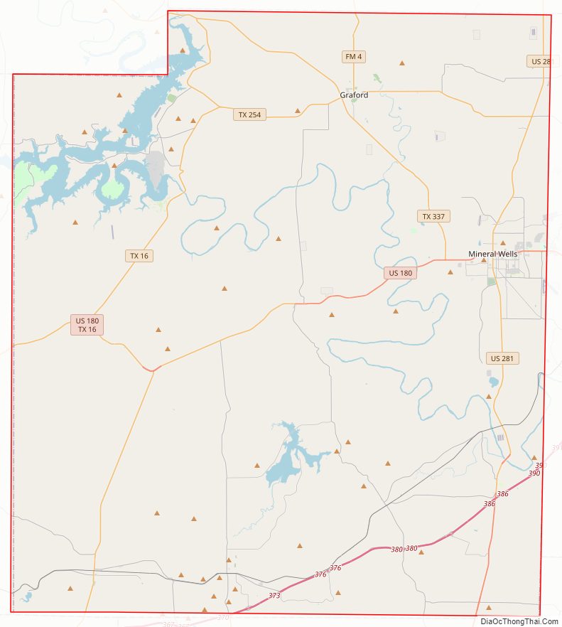
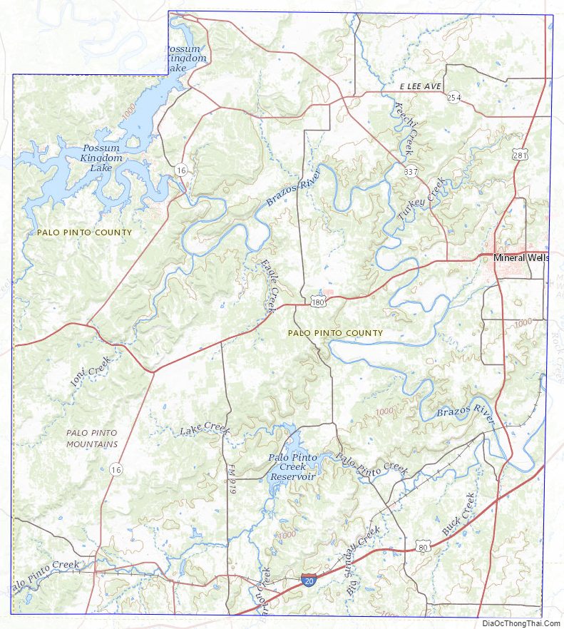
Palo Pinto County Road Map
Geography
According to the U.S. Census Bureau, the county has a total area of 986 sq mi (2,550 km), of which 34 sq mi (88 km) (3.4%) are covered by water.
Features
- Palo Pinto Mountains
- Brazos River
- Possum Kingdom Lake
Major highways
- Interstate 20
- U.S. Highway 180
- U.S. Highway 281
- State Highway 16
- State Highway 108
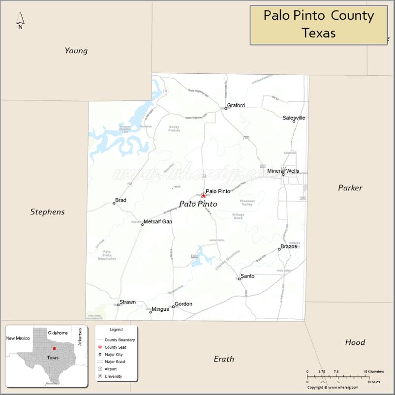
Adjacent counties
- Jack County (north)
- Parker County (east)
- Hood County (southeast)
- Erath County (south)
- Eastland County (southwest)
- Stephens County (west)
- Young County (northwest)
Palo Pinto County Topographic Map
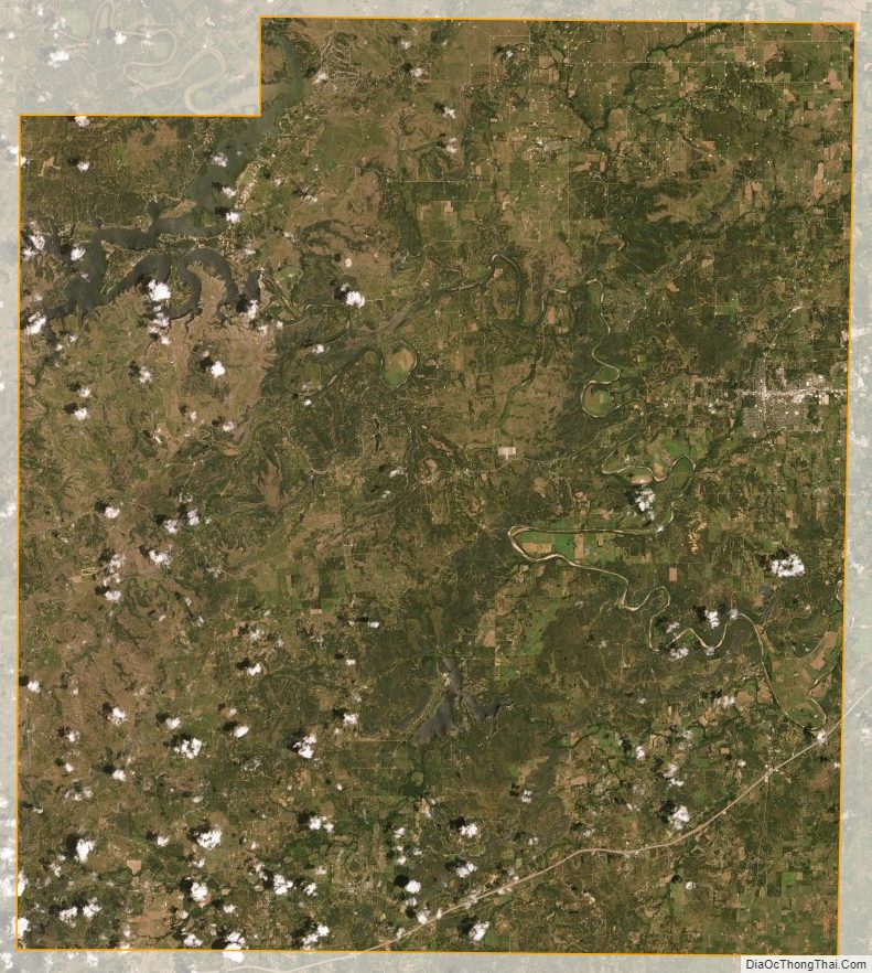
Palo Pinto County Satellite Map
Palo Pinto County Outline Map

See also
Map of Texas State and its subdivision:- Anderson
- Andrews
- Angelina
- Aransas
- Archer
- Armstrong
- Atascosa
- Austin
- Bailey
- Bandera
- Bastrop
- Baylor
- Bee
- Bell
- Bexar
- Blanco
- Borden
- Bosque
- Bowie
- Brazoria
- Brazos
- Brewster
- Briscoe
- Brooks
- Brown
- Burleson
- Burnet
- Caldwell
- Calhoun
- Callahan
- Cameron
- Camp
- Carson
- Cass
- Castro
- Chambers
- Cherokee
- Childress
- Clay
- Cochran
- Coke
- Coleman
- Collin
- Collingsworth
- Colorado
- Comal
- Comanche
- Concho
- Cooke
- Coryell
- Cottle
- Crane
- Crockett
- Crosby
- Culberson
- Dallam
- Dallas
- Dawson
- Deaf Smith
- Delta
- Denton
- Dewitt
- Dickens
- Dimmit
- Donley
- Duval
- Eastland
- Ector
- Edwards
- El Paso
- Ellis
- Erath
- Falls
- Fannin
- Fayette
- Fisher
- Floyd
- Foard
- Fort Bend
- Franklin
- Freestone
- Frio
- Gaines
- Galveston
- Garza
- Gillespie
- Glasscock
- Goliad
- Gonzales
- Gray
- Grayson
- Gregg
- Grimes
- Guadalupe
- Hale
- Hall
- Hamilton
- Hansford
- Hardeman
- Hardin
- Harris
- Harrison
- Hartley
- Haskell
- Hays
- Hemphill
- Henderson
- Hidalgo
- Hill
- Hockley
- Hood
- Hopkins
- Houston
- Howard
- Hudspeth
- Hunt
- Hutchinson
- Irion
- Jack
- Jackson
- Jasper
- Jeff Davis
- Jefferson
- Jim Hogg
- Jim Wells
- Johnson
- Jones
- Karnes
- Kaufman
- Kendall
- Kenedy
- Kent
- Kerr
- Kimble
- King
- Kinney
- Kleberg
- Knox
- La Salle
- Lamar
- Lamb
- Lampasas
- Lavaca
- Lee
- Leon
- Liberty
- Limestone
- Lipscomb
- Live Oak
- Llano
- Loving
- Lubbock
- Lynn
- Madison
- Marion
- Martin
- Mason
- Matagorda
- Maverick
- McCulloch
- McLennan
- McMullen
- Medina
- Menard
- Midland
- Milam
- Mills
- Mitchell
- Montague
- Montgomery
- Moore
- Morris
- Motley
- Nacogdoches
- Navarro
- Newton
- Nolan
- Nueces
- Ochiltree
- Oldham
- Orange
- Palo Pinto
- Panola
- Parker
- Parmer
- Pecos
- Polk
- Potter
- Presidio
- Rains
- Randall
- Reagan
- Real
- Red River
- Reeves
- Refugio
- Roberts
- Robertson
- Rockwall
- Runnels
- Rusk
- Sabine
- San Augustine
- San Jacinto
- San Patricio
- San Saba
- Schleicher
- Scurry
- Shackelford
- Shelby
- Sherman
- Smith
- Somervell
- Starr
- Stephens
- Sterling
- Stonewall
- Sutton
- Swisher
- Tarrant
- Taylor
- Terrell
- Terry
- Throckmorton
- Titus
- Tom Green
- Travis
- Trinity
- Tyler
- Upshur
- Upton
- Uvalde
- Val Verde
- Van Zandt
- Victoria
- Walker
- Waller
- Ward
- Washington
- Webb
- Wharton
- Wheeler
- Wichita
- Wilbarger
- Willacy
- Williamson
- Wilson
- Winkler
- Wise
- Wood
- Yoakum
- Young
- Zapata
- Zavala
- Alabama
- Alaska
- Arizona
- Arkansas
- California
- Colorado
- Connecticut
- Delaware
- District of Columbia
- Florida
- Georgia
- Hawaii
- Idaho
- Illinois
- Indiana
- Iowa
- Kansas
- Kentucky
- Louisiana
- Maine
- Maryland
- Massachusetts
- Michigan
- Minnesota
- Mississippi
- Missouri
- Montana
- Nebraska
- Nevada
- New Hampshire
- New Jersey
- New Mexico
- New York
- North Carolina
- North Dakota
- Ohio
- Oklahoma
- Oregon
- Pennsylvania
- Rhode Island
- South Carolina
- South Dakota
- Tennessee
- Texas
- Utah
- Vermont
- Virginia
- Washington
- West Virginia
- Wisconsin
- Wyoming