Sainte Genevieve County, often abbreviated Ste. Genevieve County (French: Ste-Geneviève), is a county located in the eastern portion of the U.S. state of Missouri. As of the 2020 census, the population was 18,479. The largest city and county seat is Ste. Genevieve. The county was officially organized on October 1, 1812, and is named after the Spanish district once located in the region, after Saint Genevieve, patroness of Paris, France.
It includes Ste. Genevieve, the earliest settlement west of the Mississippi River outside New Spain, and one of the French colonial mid-Mississippi valley villages. It is one of the last places where Paw Paw French is still spoken.
| Name: | Ste. Genevieve County |
|---|---|
| FIPS code: | 29-186 |
| State: | Missouri |
| Founded: | October 1, 1812 |
| Named for: | Saint Genevieve |
| Seat: | Ste. Genevieve |
| Largest city: | Ste. Genevieve |
| Total Area: | 507 sq mi (1,310 km²) |
| Land Area: | 499 sq mi (1,290 km²) |
| Total Population: | 18,479 |
| Population Density: | 36/sq mi (14/km²) |
| Time zone: | UTC−6 (Central) |
| Summer Time Zone (DST): | UTC−5 (CDT) |
| Website: | stegencounty.org |
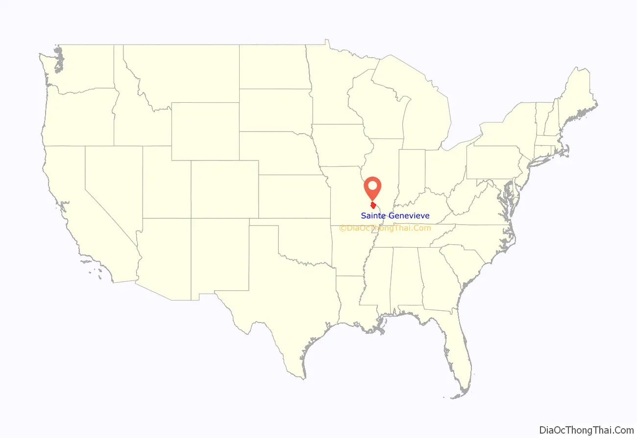
Ste. Genevieve County location map. Where is Ste. Genevieve County?
History
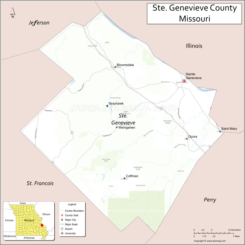
Ste. Genevieve County is located on the west bank of the Mississippi River approximately 60 miles (97 km) south of St. Louis. Ste. Genevieve is the principal town and the county seat of Ste. Genevieve County with a population of around 5,000 people.
Ste. Genevieve was the first permanent civilized settlement in Missouri. The actual date of establishment is, like many other dates, connected to genealogy. Sources do not agree on the year of founding. According to Goodspeed’s History of Southeast Missouri, and most of the descendants of the early settlers, 1735 is the most generally accepted date. Dr. Carl J. Ekberg, in his book, Colonial Ste. Genevieve, suggests that Ste. Genevieve was founded closer to 1750, based on interpretations of early letters, maps, and Catholic Church documents. Ste. Genevieve is about 250 years old.
The village of Ste. Genevieve was originally included in what was known as the Illinois Country. This was generally accepted to be all the land claimed by the French from the mouth of the Ohio River, north to the Great Lakes, and including the valleys of the Mississippi, Missouri, and Ohio rivers. The French established their seat of government for this territory in New Orleans. What is now Missouri became part of Upper Louisiana Territory. Early French explorers and settlers were known to have been in the Ste. Genevieve area in the very early 18th century.
Salt was a very important commodity at the time, used in the preservation of foods and curing of animal hides. The early French settlers were quick to exploit the salt springs on Saline Creek just south of Ste. Genevieve. Mineral explorations attracted Renault and La Motte to the area. Some of the earliest lead mines were named for La Motte in nearby Madison County.
Probably the biggest factor in the establishment of Ste. Genevieve was agriculture. Across the Mississippi River in Fort de Chartres and Kaskaskia, there was a growing need for agricultural land for the colonists. Across the Mississippi from Fort Kaskaskia was a large fertile section of river bottom, called the “Grand Champ” or Big Field. The “Old Town” of Ste. Genevieve was originally located here. It was approximately three miles south of the present site of Ste. Genevieve.
The village of Ste. Genevieve was originally an offshoot of the older French communities on the east bank of the Mississippi River—Cahokia, Kaskaskia, village of Chartres, Prairie du Rocher, and St. Philippe. The rich agricultural lands of the river bottoms were main attractions that lured most all of the early French pioneers to Ste. Genevieve. All the civil and legal business of Ste. Genevieve was transacted at Kaskaskia until about 1766 when the first commandant, Philippe de Rocheblave, was installed at Ste. Genevieve. By that time, more French migrants moved to the village from east of the river to escape British rule after France’s defeat in the Seven Years War.
Townspeople relocated Ste. Genevieve to its present higher location from the river bottoms after the devastating floods of 1785. According to a sworn statement by Julien Labriere, in October 1825, “there were about fifty or sixty cabins in the old village. The old village was overflowed so as to be on the tops of houses. The water in many places was twelve or fifteen feet deep.” The Mississippi River was the main travel route in the early decades, when it served as a means of transportation for travelers both across, and up and down the river. The first commercial ferry between Ste. Genevieve and the Illinois side was established about 1800.
When Missouri was first being settled, the Osage Native Americans were the only tribe between the Osage River and the Mississippi. They were of the same stock as the Sioux and were hostile to the whites. Around 1787, the Spanish government, which had acquired the territory from France in 1762, brought in a band of Shawnee and Delaware Native Americans, who had been friendly to the French, to help protect the settlers from the Osage.
After the French had established and settled Ste. Genevieve, the first English-speaking American settlers started showing up in about 1788, and trickled upriver from Cape Girardeau and New Madrid. Starting about 1794, after the American Revolutionary War, newly independent Americans began migrating into the Ste. Genevieve District from Pennsylvania, Virginia, Kentucky, and Tennessee.
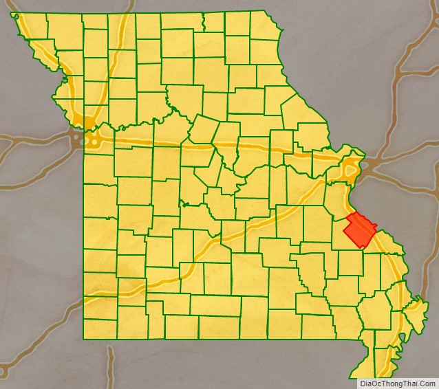
The flow increased in the early nineteenth century. In 1800, France reacquired Louisiana from Spain, and in 1803, Napoleon Bonaparte I sold it to the United States as the Louisiana Purchase. U.S. officials took over in 1804. They formed Ste. Genevieve County in 1812 as an original county of the Louisiana Territory, from the old Ste. Genevieve District. It is bordered on the east by the Mississippi River, on the north by Jefferson County, on the west by St. Francois County, and on the south by Perry County.
Starting around 1840, German Catholics began settling around New Offenburg and Zell. Shortly after wardGerman Lutherans began spreading into Ste. Genevieve from Perry County. But as late as 1930, most residents of Ste Genevieve were Catholic.
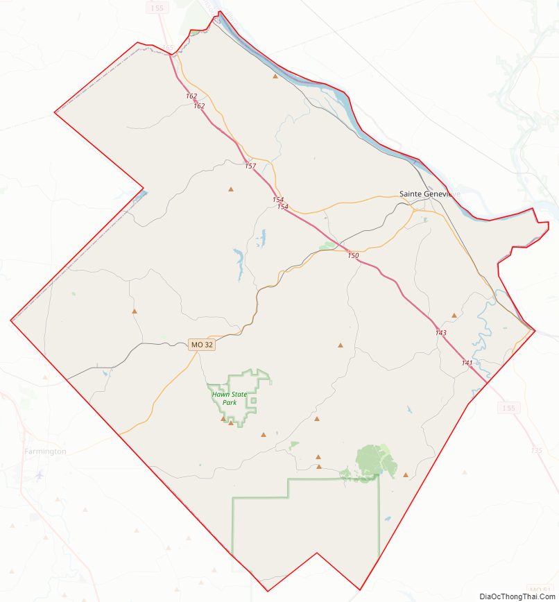
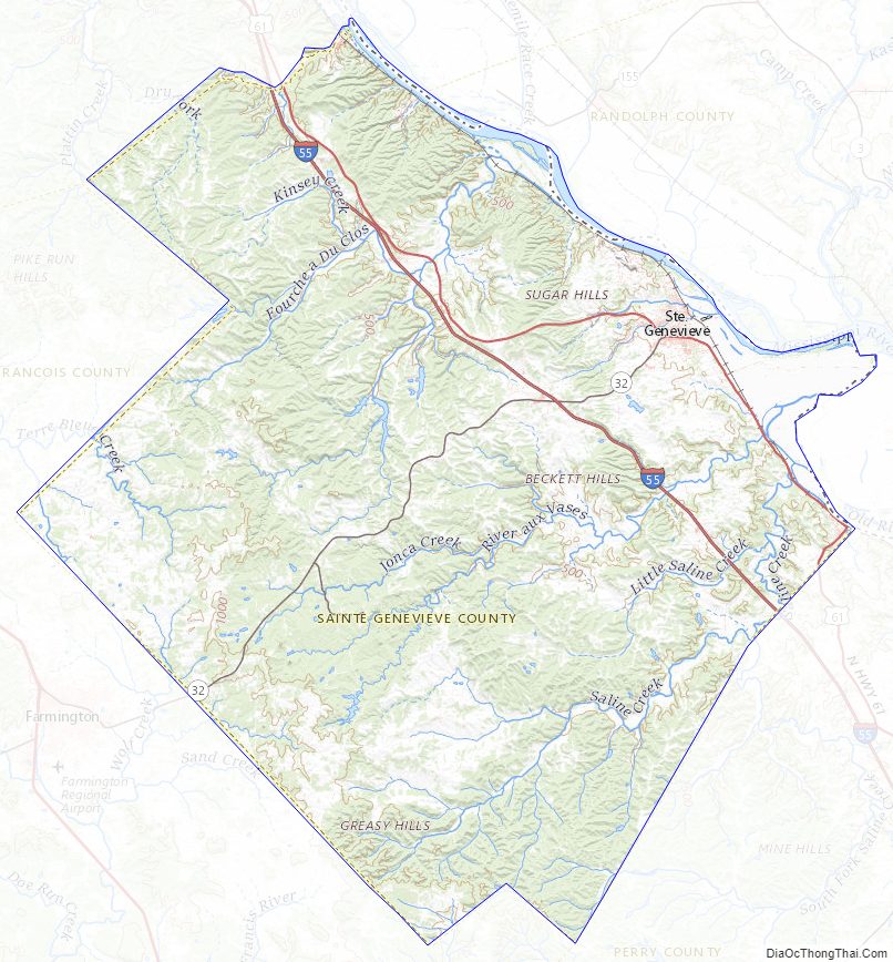
Ste. Genevieve County Road Map
Geography
According to the U.S. Census Bureau, the county has a total area of 507 square miles (1,310 km), of which 499 square miles (1,290 km) is land and 7.6 square miles (20 km) (1.5%) is water. The county’s northeastern border with Illinois is formed by the Mississippi River.
Adjacent counties
- Jefferson County (northwest)
- Monroe County, Illinois (northeast)
- Randolph County, Illinois (east)
- Perry County (southeast)
- St. Francois County (southwest)
Major highways
- Interstate 55
- U.S. Route 61
- Route 32
National protected area
- Mark Twain National Forest (part)
Mountains and hills
- Haney Hill
- Mertell Hill
- Pikes Peak
- St. Francois Mountains
Valleys
- Bidwell Hollow
- Corn Hollow
- Henry Hollow
- Lick Hollow
- Morrison Hollow
- Snell Hollow
- Staples Hollow
- Wolf Hollow
Ste. Genevieve County Topographic Map
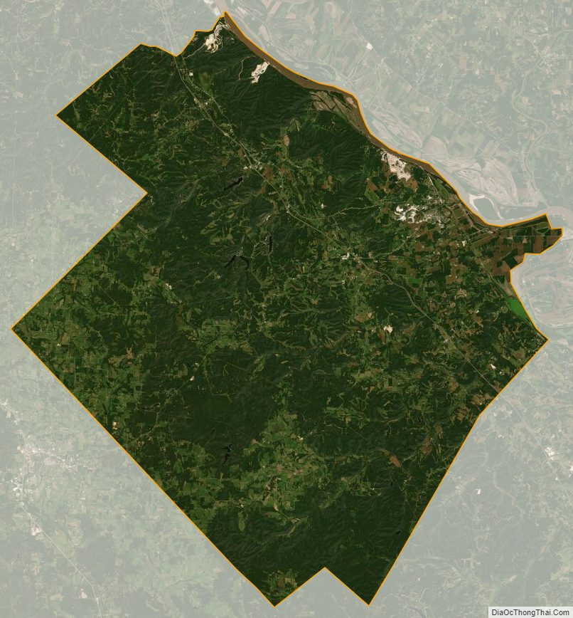
Ste. Genevieve County Satellite Map
Ste. Genevieve County Outline Map

See also
Map of Missouri State and its subdivision:- Adair
- Andrew
- Atchison
- Audrain
- Barry
- Barton
- Bates
- Benton
- Bollinger
- Boone
- Buchanan
- Butler
- Caldwell
- Callaway
- Camden
- Cape Girardeau
- Carroll
- Carter
- Cass
- Cedar
- Chariton
- Christian
- Clark
- Clay
- Clinton
- Cole
- Cooper
- Crawford
- Dade
- Dallas
- Daviess
- De Kalb
- Dent
- Douglas
- Dunklin
- Franklin
- Gasconade
- Gentry
- Greene
- Grundy
- Harrison
- Henry
- Hickory
- Holt
- Howard
- Howell
- Iron
- Jackson
- Jasper
- Jefferson
- Johnson
- Knox
- Laclede
- Lafayette
- Lawrence
- Lewis
- Lincoln
- Linn
- Livingston
- Macon
- Madison
- Maries
- Marion
- McDonald
- Mercer
- Miller
- Mississippi
- Moniteau
- Monroe
- Montgomery
- Morgan
- New Madrid
- Newton
- Nodaway
- Oregon
- Osage
- Ozark
- Pemiscot
- Perry
- Pettis
- Phelps
- Pike
- Platte
- Polk
- Pulaski
- Putnam
- Ralls
- Randolph
- Ray
- Reynolds
- Ripley
- Saint Charles
- Saint Clair
- Saint Francois
- Saint Louis
- Sainte Genevieve
- Saline
- Schuyler
- Scotland
- Scott
- Shannon
- Shelby
- Stoddard
- Stone
- Sullivan
- Taney
- Texas
- Vernon
- Warren
- Washington
- Wayne
- Webster
- Worth
- Wright
- Alabama
- Alaska
- Arizona
- Arkansas
- California
- Colorado
- Connecticut
- Delaware
- District of Columbia
- Florida
- Georgia
- Hawaii
- Idaho
- Illinois
- Indiana
- Iowa
- Kansas
- Kentucky
- Louisiana
- Maine
- Maryland
- Massachusetts
- Michigan
- Minnesota
- Mississippi
- Missouri
- Montana
- Nebraska
- Nevada
- New Hampshire
- New Jersey
- New Mexico
- New York
- North Carolina
- North Dakota
- Ohio
- Oklahoma
- Oregon
- Pennsylvania
- Rhode Island
- South Carolina
- South Dakota
- Tennessee
- Texas
- Utah
- Vermont
- Virginia
- Washington
- West Virginia
- Wisconsin
- Wyoming