Santa Clara County, officially the County of Santa Clara, is the sixth-most populous county in the U.S. state of California, with a population of 1,936,259, as of the 2020 census. Santa Clara County and neighboring San Benito County together form the U.S. Census Bureau’s San Jose-Sunnyvale-Santa Clara metropolitan statistical area, which is part of the larger San Jose-San Francisco–Oakland combined statistical area. Santa Clara is the most populous county in the San Francisco Bay Area and in Northern California. The county seat and largest city is San Jose; with about 1,000,000 residents, it is the 10th-most populous city in the United States, California’s third-most populous city and the most populous city in the San Francisco Bay Area. The second- and third-largest cities are Sunnyvale and Santa Clara.
Home to Silicon Valley, Santa Clara County is an economic center for high technology, and in 2015 had the third-highest gross domestic product (GDP) per capita in the world (after Zürich, Switzerland and Oslo, Norway), according to the Brookings Institution. Located on the southern coast of San Francisco Bay, the urbanized Santa Clara Valley within Santa Clara County contains most of the county’s population. More recently, extensive droughts in California, further complicated by drainage of the Anderson reservoir within the county for seismic repairs, have strained the county’s water security.
The county’s concentration of wealth, primarily due to the tech industry, has made it the most affluent county on the West Coast of the United States and the most affluent outside the Washington metropolitan area and one of the most affluent places in the United States.
| Name: | Santa Clara County |
|---|---|
| FIPS code: | 06-085 |
| State: | California |
| Founded: | 1850 |
| Named for: | Mission Santa Clara de Asís, St. Clare of Assisi |
| Seat: | San Jose |
| Total Area: | 1,304 sq mi (3,380 km²) |
| Land Area: | 1,290 sq mi (3,300 km²) |
| Total Population: | 1,936,259 |
| Population Density: | 1,500/sq mi (570/km²) |
| Time zone: | UTC−8 (Pacific) |
| Summer Time Zone (DST): | UTC−7 (Pacific Daylight Time) |
| Website: | www.sccgov.org |
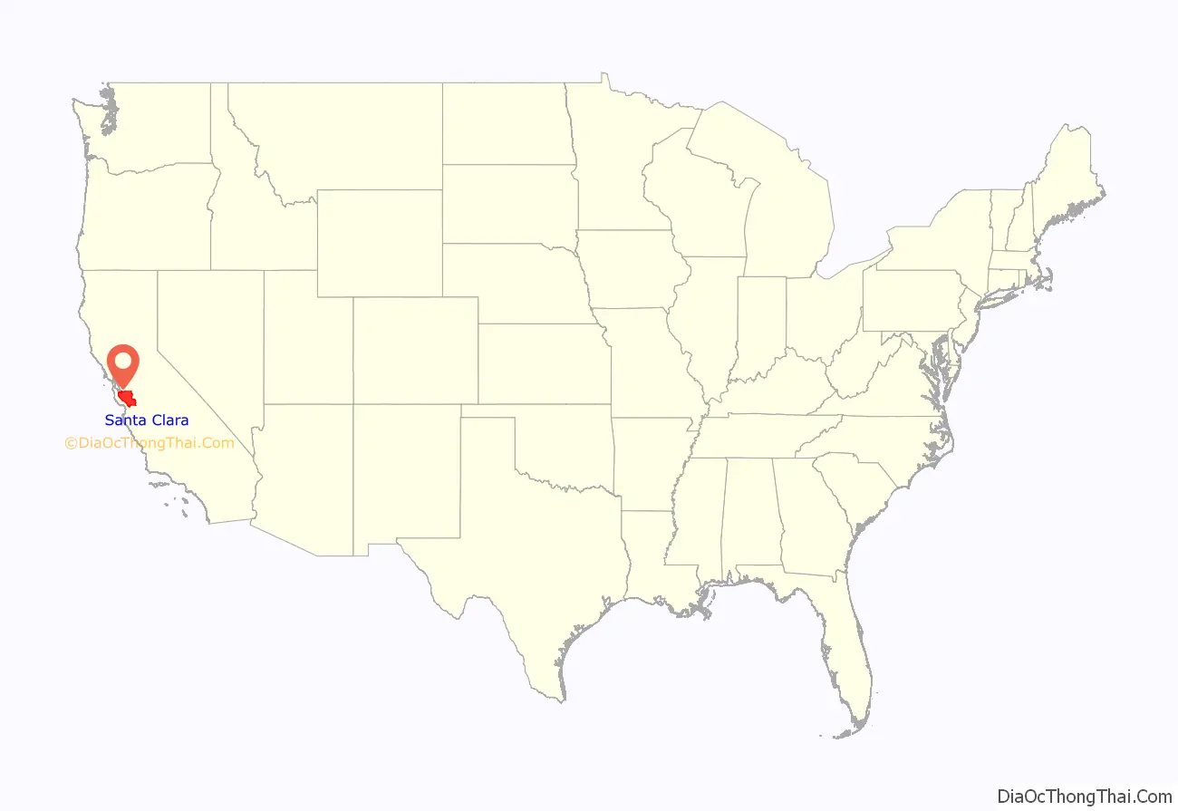
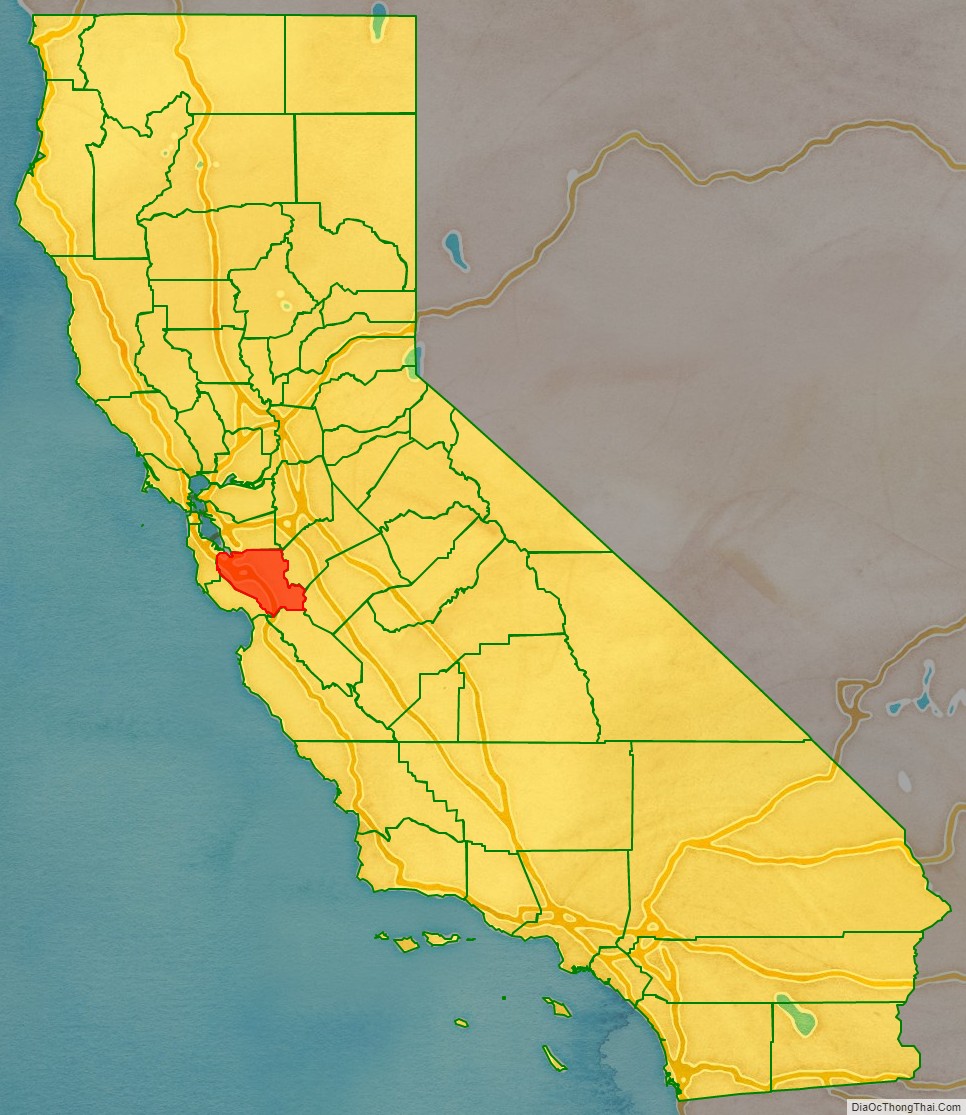
Santa Clara County location map. Where is Santa Clara County?
History
Santa Clara County was one of the original counties of California, formed in 1850 at the time of statehood. The original inhabitants included the Ohlone, residing on Coyote Creek and Calaveras Creek. Part of the county’s territory was given to Alameda County in 1853.
In 1882, Santa Clara County tried to levy taxes upon property of the Southern Pacific Railroad within county boundaries. The result was the U.S. Supreme Court case of Santa Clara County v. Southern Pacific Railroad, 118 U.S. 394 (1886), in which the court extended due-process rights to artificial legal entities.
In the early 20th century, the area was promoted as the “Valley of the Heart’s Delight” due to its natural beauty, including a significant number of orchards.
The first major technology company to be based in the area was Hewlett-Packard, founded in a garage in Palo Alto in 1939. IBM selected San Jose as its West Coast headquarters in 1943. Varian Associates, Fairchild Semiconductor, and other early innovators were in the county by the late 1940s and 1950s. The U.S. Navy had a large presence in the area and began giving large contracts to Silicon Valley electronics companies. The term “Silicon Valley” was coined in 1971. The trend accelerated in the 1980s and 1990s, and agriculture has since been nearly eliminated from the northern part of the county.
Today, Santa Clara County is the headquarters for about 6500 high-technology companies, including many of the largest ones in the world, among them hardware manufacturers AMD, Nvidia, Cisco Systems, and Intel, computer and consumer electronics companies Apple Inc. and Hewlett-Packard, and internet companies eBay, Google, and Yahoo!. Most of what is considered to be Silicon Valley is within the county, although some adjoining tech regions in San Mateo (e.g., Facebook), Alameda, and Santa Cruz counties are also considered part of Silicon Valley.
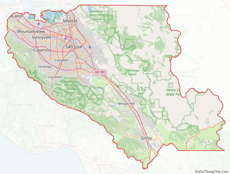
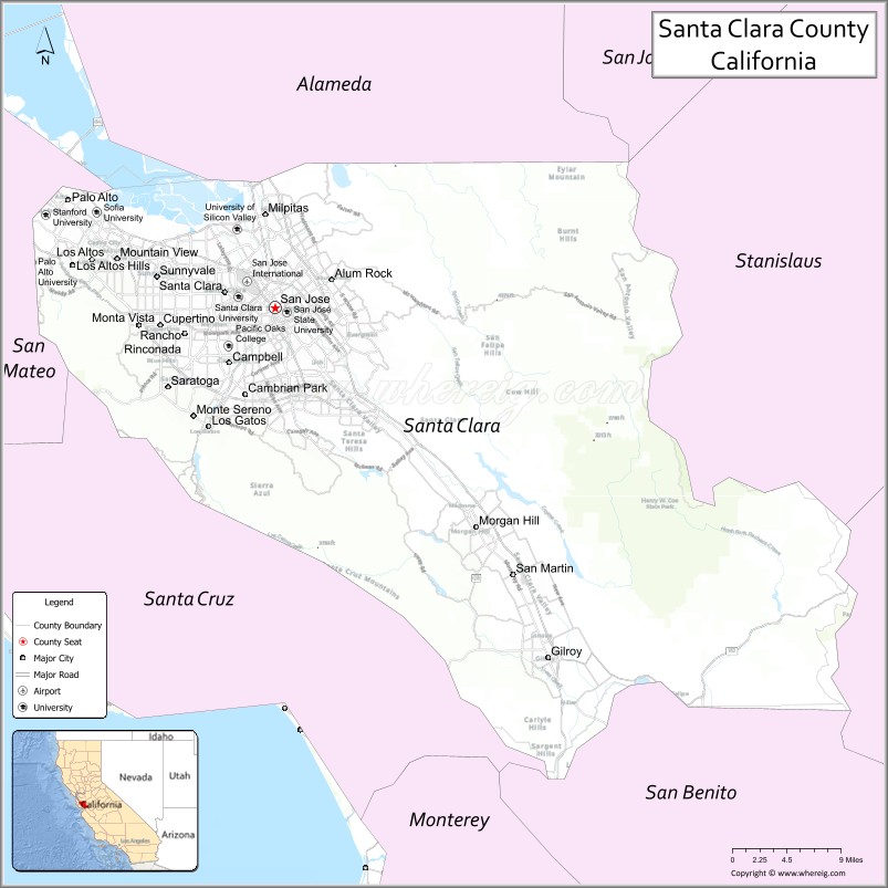
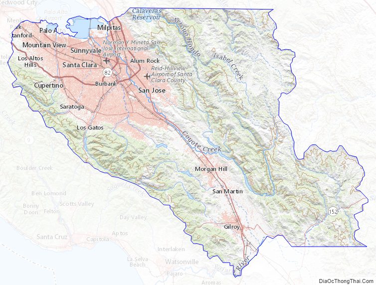
Santa Clara County Road Map
Geography
According to the U.S. Census Bureau, the county has a total area of 1,304 square miles (3,380 km), of which 14 square miles (36 km) (1.1%) are covered by water.
Counties which border with Santa Clara County are, clockwise, Alameda County, San Joaquin (within a few hundred feet at Mount Boardman), Stanislaus, Merced, San Benito, Santa Cruz, and San Mateo County. Santa Clara County formerly shared borders with Contra Costa, San Francisco, Mariposa, Monterey, and Tuolumne counties until 1853, 1856, 1874, and 1854 respectively (Monterey County currently comes within a few miles of Santa Clara).
The San Andreas Fault runs along the Santa Cruz Mountains in the south and west of the county.
National protected area
- Don Edwards San Francisco Bay National Wildlife Refuge (part)
Fauna
Both tule elk (Cervus canadensis nannodes) and pronghorn (Antilocapra americana) were historically native to Santa Clara County. In June 1776, Lieutenant Commander Don José Joaquín Moraga led a group of soldiers and colonists from the Presidio of Monterey to establish Mission San Francisco de Asis and encountered both tule elk and pronghorn, and clearly distinguished these two species from deer. The deer in California being California mule deer (Odocoileus hemionus).
Regarding elk, Moraga wrote: “In the great plain called San Bernardino (the Santa Clara Valley which stretches from south San Jose to Gilroy), while the expedition was strung out at length, we descried in the distance a herd of large animals that looked like cattle, but we could not imagine where they belonged or from whence they had come…with horns similar in shape to those of the deer, but so large that they measured sixteen palms from tip to tip.” Upon measurement, Morago reported the elk horns as four varas [11 feet] across… “These animals [elk] are called ciervos in order to differentiate them from the ordinary Spanish variety of deer, here called venados, which also exist in abundance and of large size in the vicinity.”
Regarding pronghorn, Moraga reported: “In the said plains of San Bernardino (Santa Clara Valley)…there is another species of deer about the size of three-year-old sheep. They are similar in appearance to the deer, except they have short horns and also short legs like the sheep. They live in the plains where they go in herds of 100, 200, or more. They run all together over the plains so fast that they seem to fly…These animals are called berrendos and there are many of them also in the southern Missions wherever the country is level.”
Herbert Eugene Bolton also wrote of elk reports from another Spanish expedition, from the De Anza Expedition on March 23, 1776: ” In Gilroy Valley (Santa Clara Valley) Moraga ‘s larder was replenished by three elks which the men killed without leaving the road.” General John Bidwell, of the 1841 Bartleson-Bidwell Party wrote: “In some of the fertile valleys, such as Napa and Santa Clara, there were elk literally by the thousand.”
In 1978, California Department of Fish and Game warden Henry Coletto urged the department to choose the Mount Hamilton area as one of California’s relocation sites under a new statewide effort to restore tule elk. While other ranchers refused, tech pioneers Bill Hewlett and David Packard allowed Coletto and state biologists to translocate the initial 32 tule elk from the Owens Valley in the eastern Sierra onto the 28,000-acre (11,000 ha) San Felipe Ranch, which the families jointly own, in the hills east of Morgan Hill. From the three original 1978–1981 translocations (totaling 65 animals) to the Mount Hamilton region of the Diablo Range, there are multiple herds in different locations including the Isabel Valley, San Antonio Valley, Livermore area, San Felipe Ranch, Metcalf Canyon, Coyote Ridge, Anderson Lake, and surrounding areas such as the Sunol and Cottonwood Creek (near San Luis Reservoir in western Merced County, California) herds. As of 2012, an estimated 400 tule elk roam 1,875 square kilometres (724 sq mi) in northeastern Santa Clara County and southeastern Alameda County. In March 2014 CDFW translocated nine bull elk from the San Luis National Wildlife Refuge to add genetic diversity to the San Antonio Valley Ecological Reserve herd in San Antonio Valley in extreme eastern Santa Clara County. As of 2017 there were four herds in the Coyote Ridge area, often visible from U. S. Highway 101, according to Craige Edgerton, recently retired executive director of the Silicon Valley Land Conservancy and local naturalist Michael Hundt. In 2019, a fifth herd of tule elk was documented by local naturalist Roger Castillo, likely having split from the Coyote Ridge herd and established itself in Silver Creek Valley around the closed Ranch Golf Club. The elk herds in eastern Santa Clara County are blocked from dispersal to the west by U.S. Highway 101, with environmentalists advocating re-purposing the Metcalf Road bridge at the Coyote Gap into a wildlife overcrossing. This would enable elk to recolonize rural southwestern Santa Clara County, as well as Santa Cruz and San Mateo Counties.
In 1990, the California Department of Fish and Game’s Henry Coletto translocated excess pronghorn from Modoc County to six locations in California, including 51 animals to the San Felipe Ranch in Santa Clara County, where the swift-footed ungulates had not lived for generations. The animals left the San Felipe Ranch for the Isabel and San Antonio Valleys, as well as an area near Lake Del Valle in Alameda County may now be extirpated by poaching, highway vehicle collisions, and insufficient numbers to defend pronghorn fawns against coyote predation. As of 2012, the Isabel Valley Ranch herd had dwindled to 3 animals, and the Lake del Valle herd to 13. Currently, iNaturalist.org has zero observer records of pronghorn in Santa Clara County.
The Nature Conservancy “Mount Hamilton Project” has acquired or put under conservation easement 100,000 acres (40,000 ha) of land towards its 500,000 acres (200,000 ha) goal for habitat conservation within a 1,200,000 acres (490,000 ha) area encompassing much of eastern Santa Clara County as well as portions of southern Alameda County, western Merced and Stanislaus Counties, and northern San Benito County. Acquisitions to date include the 1,756-acre (711 ha) Rancho Cañada de Pala, straddling the Alameda Creek and Coyote Creek watersheds for California tiger salamander habitat; a conservation easement on the 3,259-acre Blue Oak Ranch Reserve, which abuts the north side of Joseph D. Grant County Park; a conservation easement on the 28,359-acre San Felipe Ranch, connecting Joseph D. Grant County Park with Henry W. Coe State Park; the 2,899-acre South Valley Ranch which protects a tule elk herd in the San Antonio Valley, and other properties.
As of 1980, Santa Clara County had the highest number of Superfund Sites of any county in the United States, accounting for 25 polluted locations requiring a long-term response to clean up hazardous material contaminations. As of 2019, Santa Clara County has 23 active Superfund Sites, still more than any other county in the United States. The vast majority of these Superfund sites were caused by firms associated with the high tech sector in Silicon Valley.
Santa Clara County Topographic Map
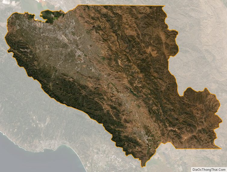
Santa Clara County Satellite Map
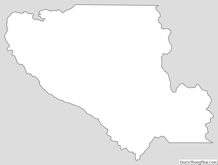
Santa Clara County Outline Map
See also
Map of California State and its subdivision:- Alameda
- Alpine
- Amador
- Butte
- Calaveras
- Colusa
- Contra Costa
- Del Norte
- El Dorado
- Fresno
- Glenn
- Humboldt
- Imperial
- Inyo
- Kern
- Kings
- Lake
- Lassen
- Los Angeles
- Madera
- Marin
- Mariposa
- Mendocino
- Merced
- Modoc
- Mono
- Monterey
- Napa
- Nevada
- Orange
- Placer
- Plumas
- Riverside
- Sacramento
- San Benito
- San Bernardino
- San Diego
- San Francisco
- San Joaquin
- San Luis Obispo
- San Mateo
- Santa Barbara
- Santa Clara
- Santa Cruz
- Shasta
- Sierra
- Siskiyou
- Solano
- Sonoma
- Stanislaus
- Sutter
- Tehama
- Trinity
- Tulare
- Tuolumne
- Ventura
- Yolo
- Yuba
- Alabama
- Alaska
- Arizona
- Arkansas
- California
- Colorado
- Connecticut
- Delaware
- District of Columbia
- Florida
- Georgia
- Hawaii
- Idaho
- Illinois
- Indiana
- Iowa
- Kansas
- Kentucky
- Louisiana
- Maine
- Maryland
- Massachusetts
- Michigan
- Minnesota
- Mississippi
- Missouri
- Montana
- Nebraska
- Nevada
- New Hampshire
- New Jersey
- New Mexico
- New York
- North Carolina
- North Dakota
- Ohio
- Oklahoma
- Oregon
- Pennsylvania
- Rhode Island
- South Carolina
- South Dakota
- Tennessee
- Texas
- Utah
- Vermont
- Virginia
- Washington
- West Virginia
- Wisconsin
- Wyoming