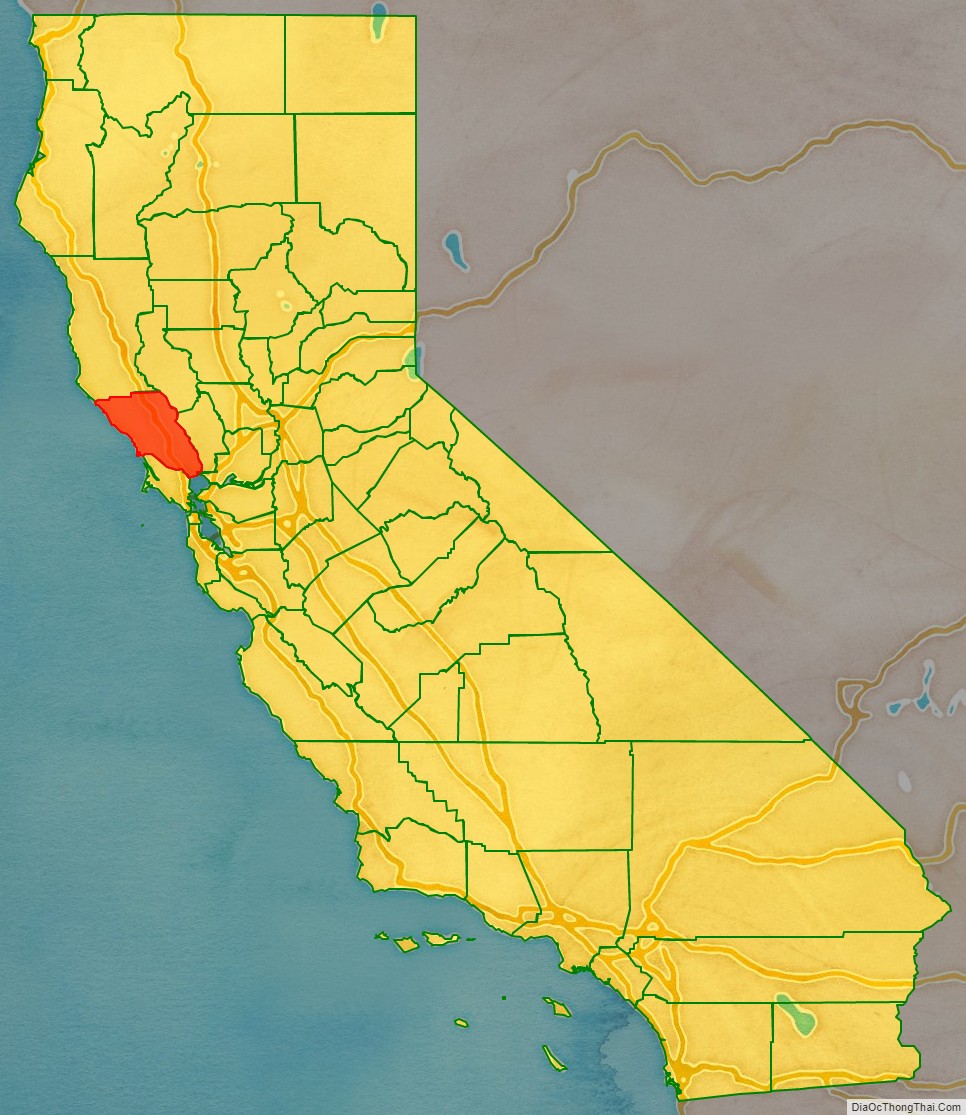
Sonoma County (/səˈnoʊmə/ (listen)) is a county located in the U.S. state of California. As of the 2020 United States Census, its population was 488,863. Its county seat and largest city is Santa Rosa. It is to the north of Marin County and the south of Mendocino County. It is west of Napa County and Lake County.
Sonoma County comprises the Santa Rosa-Petaluma Metropolitan Statistical Area, which is part of the San Jose–San Francisco–Oakland, CA Combined Statistical Area. It is the northernmost county in the nine-county San Francisco Bay Area region.
In California’s Wine Country region, which also includes Napa, Mendocino, and Lake counties, Sonoma County is the largest producer. It has thirteen approved American Viticultural Areas and more than 350 wineries. The voters have twice approved open space initiatives that have provided funding for public acquisition of natural areas, preserving forested areas, coastal habitat, and other open space. More than 8.4 million tourists visit each year, spending more than $1 billion in 2016.
In 2012, Sonoma County ranked as the 22nd county in the United States in agricultural production. By 1920, Sonoma County was ranked as the eighth most agriculturally productive U.S. county and a leading producer of hops, grapes, prunes, apples, as well as dairy and poultry products, largely due to the extent of available, fertile agricultural land in addition to the abundance of high-quality water for irrigation. As of 2009, agriculture was largely divided between two nearly monocultural uses: grapes and pasturage.
| Name: | Sonoma County |
|---|---|
| FIPS code: | 06-097 |
| State: | California |
| Founded: | 1850 |
| Named for: | the city of Sonoma |
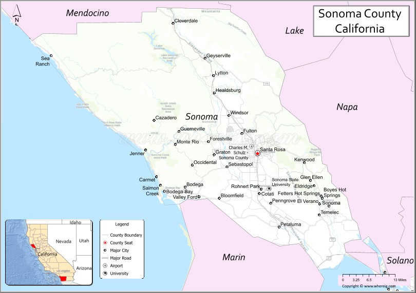
| Seat: | Santa Rosa |
| Total Area: | 1,768 sq mi (4,580 km²) |
| Land Area: | 1,576 sq mi (4,080 km²) |
| Total Population: | 488,863 |
| Population Density: | 280/sq mi (110/km²) |
| Time zone: | UTC−8 (Pacific Time Zone) |
| Summer Time Zone (DST): | UTC−7 (Pacific Daylight Time) |
| Website: | sonomacounty.ca.gov |
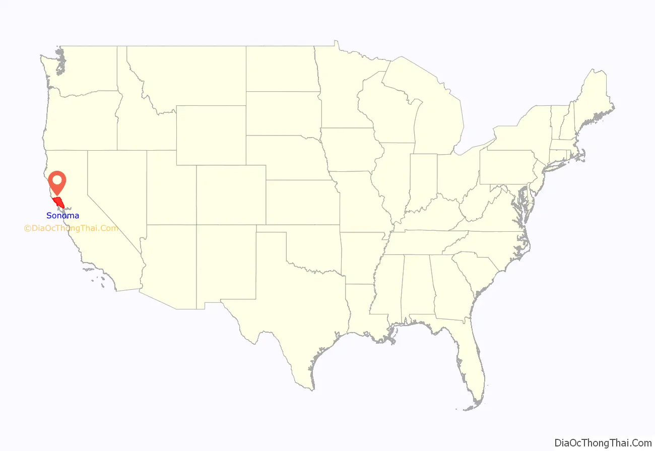
Sonoma County location map. Where is Sonoma County?
History
The Pomo, Coast Miwok and Wappo peoples were the earliest human settlers of Sonoma County, between 8000 and 5000 BC, effectively living within the natural carrying capacity of the land. Archaeological evidence of these First people includes a number of occurrences of rock carvings, especially in southern Sonoma County; these carvings often take the form of pecked curvilinear nucleated design.
Spaniards, Russians, and other Europeans claimed and settled in the county from the late 16th to mid-19th century, seeking timber, fur, and farmland. The Russians were the first newcomers to establish a permanent foothold in Sonoma County, with the Russian-American Company establishing Fort Ross on the Sonoma Coast in 1812. This settlement and its outlying Russian settlements came to include a population of several hundred Russian and Aleut settlers and a stockaded fort with artillery. However, the Russians abandoned it in 1841 and sold the fort to John Sutter, settler and Mexican land grantee of Sacramento.
The Mission San Francisco Solano, founded in 1823 as the last and northernmost of 21 California missions, is in the present City of Sonoma, at the northern end of El Camino Real. El Presidio de Sonoma, or Sonoma Barracks (part of Spain’s Fourth Military District), was established in 1836 by Comandante General Mariano Guadalupe Vallejo. His duties included keeping an eye on the Russian traders at Fort Ross, secularizing the Mission, maintaining cooperation with the Native Americans of the entire region, and doling out the lands for large estates and ranches. The City of Sonoma was the site of the Bear Flag Revolt in 1846.
Sonoma was one of the original counties when California became a state in 1850, with its county seat originally the town (now city) of Sonoma. However, by the early 1850s, Sonoma had declined in importance in both commerce and population, its county buildings were crumbling, and it was relatively remote. As a result, elements in the newer, rapidly growing towns of Petaluma, Santa Rosa, and Healdsburg began vying to move the county seat to their towns. The dispute ultimately was between the bigger, richer commercial town of Petaluma and the more centrally located, growing agricultural center of Santa Rosa. The fate was decided following an election for the state legislature in which James Bennett of Santa Rosa defeated Joseph Hooker of Sonoma and introduced a bill that resulted in Santa Rosa being confirmed as county seat in 1854. Allegedly, several Santa Rosans, not caring to wait, decided to take action and, one night, rode down the Sonoma Valley to Sonoma, took the county seals and records, and brought them to Santa Rosa. Some of the county’s land was annexed from Mendocino County between 1850 and 1860.
Early post-1847 settlement and development focused primarily on the city of Sonoma, then the region’s sole town and a common transit and resting point in overland travel between the region and Sacramento and the gold fields to the east. However, after 1850, a settlement that soon became the city of Petaluma began to grow naturally near the farthest navigable point inland up the Petaluma River. Originally a hunting camp used to obtain game to sell in other markets, by 1854 Petaluma had grown into a bustling center of trade, taking advantage of its position on the river near a region of highly productive agricultural land that was being settled. Soon, other inland towns, notably Santa Rosa and Healdsburg began to develop similarly due to their locations along riparian areas in prime agricultural flatland. However, their development initially lagged behind Petaluma which, until the arrival of railroads in the 1860s, remained the primary commercial, transit, and break-of-bulk point for people and goods in the region. After the arrival of the San Francisco and North Pacific Railroad in 1870, Santa Rosa began to boom, soon equalling and then surpassing Petaluma as the region’s population and commercial center. The railroad bypassed Petaluma for southern connections to ferries of San Francisco Bay.
Six nations have claimed Sonoma County from 1542 to the present:
Sonoma County was severely shaken by the 1906 San Francisco earthquake. The displacements along the fault averaged 15 feet (4.6 m).
In October 2017, the county was greatly affected by the Tubbs Fire and the Nuns Fire. In late October and early November 2019, the Kincade Fire burned 77,758 acres (31,468 ha), almost all in Sonoma County. In August and September 2020, the Walbridge Fire burned 55,209 acres (22,342 ha) in the western part of the county; then in September–October the Glass fire affected the city of Santa Rosa and ultimately destroying 1,000+ buildings The county also had a wildfire in the 1870s that is compared to the Hanley fire and Tubbs fire because they burned in the same path.
The Sonoma County Landmarks Commission recognizes nearly 200 formal historical landmarks and the Sonoma County Historical Society counts 380 landmarks recognized by several agencies.
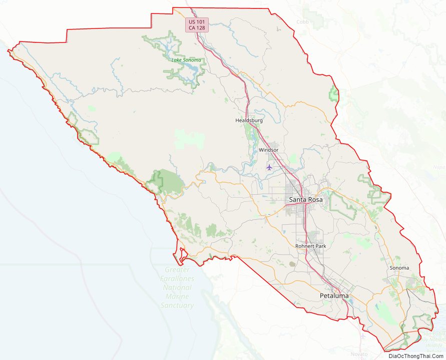
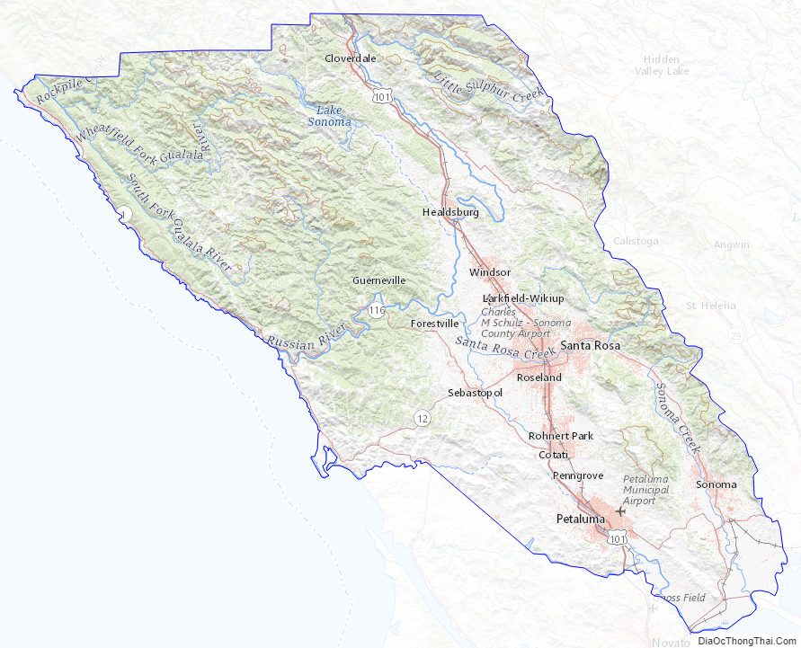
Sonoma County Road Map
Geography
According to the U.S. Census Bureau, the county has an area of 1,768 square miles (4,580 km), of which 1,576 square miles (4,080 km) is land and 192 square miles (500 km) (10.9%) is water.
The county lies in the North Coast Ranges of northwestern California. Its ranges include the Mayacamas and the Sonoma Mountains, the southern peak of the latter being the prominent landform Sears Point. The highest peak in the Mayacamas within the county and the highest peak in the County is Mt. Saint Helena. It has uncommon occurrences of pygmy forest, dominated by Mendocino cypress. The highest peak of the Sonoma Mountains is Sonoma Mountain itself, which boasts two significant public access properties: Jack London State Historic Park and Fairfield Osborn Preserve.
The county includes the City of Sonoma and the Sonoma Valley, in which the City of Sonoma is located. However, these are not synonymous. The City of Sonoma is merely one of nine incorporated cities in the county. The Sonoma Valley is just the southeastern portion of the county, which includes many other valleys and geographic zones, including the Petaluma Valley, the Santa Rosa Plains, the Russian River, the Alexander Valley, and the Dry Creek Valley.
Distinct habitat areas within the county include oak woodland, redwood forest, northern coastal scrub, grassland, marshland, oak savanna and riparian woodland. The California oak woodland in the upper Yulupa Creek and Spring Creek watersheds in Annadel State Park is a relatively undisturbed ecosystem with considerable biodiversity. These forested areas have been characterized as some of the best examples of such woodlands. An unusual characteristic of these forests is the high content of undisturbed prehistoric bunchgrass understory, testifying to the absence of historic grazing or other agriculture.
Trees of the oak woodland habitat include Pacific madrone, Douglas fir, coast live oak, Garry oak, and California laurel. Common understory plants are toyon, poison oak, and, at the fringes, coast silk-tassel.
Climate
Sonoma County, as is often the case with coastal counties in California, has a great degree of climatic variation and numerous, often very different, microclimates. Key determining factors for local climate are proximity to the ocean, elevation, and the presence and elevation of hills or mountains to the east and west. This is in large part due to the fact that, as throughout California, the prevailing weather systems and wind come normally from the Pacific Ocean, blowing in from the west and southwest, so that places closer to the ocean and on the windward side of higher elevations tend to receive more rain from autumn through spring and more summer wind and fog. This itself is partly a result of the presence of high and low pressures in inland California, with persistent high summer temperatures in the Central Valley, in particular, leading to low pressures, drawing in moist air from the Pacific, cooling into damp cool breezes and fog over the cold coastal water. Those places further inland and particularly in the lee of significant elevations tend to receive less rain and less, in some cases no, fog in the summer.
The coast itself is typically cool and moist throughout summer, often foggy, with fog generally blowing in during the late afternoon and evening until it clears in the later morning becoming sunny, before repeating. Coastal summer highs are typically in the mid to high 60s, warming to the low 70s further from the ocean.
Certain inland areas, including the Petaluma area and the Santa Rosa Plain, are also prone to this normal fog pattern in general. However, they tend to receive the fog later in the evening, the fog tends to be more short-lived, and mid-day temperatures are significantly higher than they are on the coast, typically in the low 80s F. This is particularly true for Petaluma, Cotati, and Rohnert Park, and, only slightly less so, Santa Rosa, Windsor, and Sebastopol. In large part, this results from lower elevations and the prominent Petaluma Gap in the hills between the ocean to the west and the Petaluma Valley and Santa Rosa Plain to the east.
Areas north of Santa Rosa and Windsor, with larger elevations to the west and further from the fog path, tend to receive less fog and less summer marine influence. Healdsburg, to the north of Windsor, is less foggy and much warmer, with summer highs typically in the higher 80s to about 90 °F (32 °C). Sonoma and the Sonoma Valley, east of Petaluma, are similar, with highs typically in the very high 70s F to 80 °F (27 °C). This is in part due to the presence of the Sonoma Mountains between Petaluma and Sonoma. Cloverdale, far to the north and outside of the Santa Rosa Plain, is significantly hotter than any other city in the county, with rare evening-morning fog and highs often in the 90s, reaching 100 °F (38 °C) much more frequently than the other cities. Notably, however, the temperature differences among the different areas of the county are greatest for the highs during mid-day, with the diurnal lows much more even throughout the entire county. The lows are closely tied to the evening-morning cooling marine influence, in addition to elevation, bringing similarly cool temperatures to much of region.
These weather patterns contribute to high diurnal temperature fluctuations in much of the county. In summer, daily lows and highs are typically 30–40 °F apart inland, with highs for Petaluma, Cotati, Rohnert Park, Santa Rosa, Windsor, and Sebastopol typically being in the very low 80s F and lows at or near 50 °F (10 °C). Healdsburg and the City of Sonoma, with similar lows, have even greater diurnal fluctuations due to their significantly warmer highs. On the other hand, the coast, with strong marine influence, tends to have low diurnal temperature fluctuation, with summer highs much cooler than the inland towns, typically 65–75 °F, yet lows in the high 40s to low 50s F, fairly comparable to most inland towns.
These microclimates are evident during the rainy seasons as well, with great variation in the amount of rainfall throughout the county. Generally, all of Sonoma County receives a fair amount of rain, with much of the county receiving between about 25 in (640 mm), comparable to areas such as Sonoma and Petaluma, and roughly 30 in (760 mm) normal for Santa Rosa. However, certain areas, particularly in the north-west portion of the county around the Russian River, receive significantly more rainfall. The Guerneville area, for example, typically receives about 50 in (1,300 mm) of rain a year, with annual rain occasionally going as high as 70 in (1,800 mm). Nearby Cazadero typically receives about 72 in (1,800 mm) of rain a year, many times has reached over 100 in (2,500 mm) a year, and sometimes over 120 in (3,000 mm) of rain in a year. The Cazadero region is the second wettest place in California after Gasquet.
Snow is exceedingly rare in Sonoma County, except in the higher elevations on and around the Mayacamas Mountains, particularly Mount Saint Helena, and Cobb Mountain, whose peak is in Lake County.
Ocean, bays, rivers and streams
Sonoma County is bounded on the west by the Pacific Ocean, and has 76 miles (122 km) of coastline. The major coastal hydrographic features are Bodega Bay, the mouth of the Russian River, and the mouth of the Gualala River, at the border with Mendocino County. All of the county’s beaches were listed as among the cleanest in the state in 2010.
Six of the county’s nine cities, from Healdsburg south through Santa Rosa to Rohnert Park and Cotati, are in the Santa Rosa Plain. The northern Plain drains directly to the Russian River, or to a tributary; the southern Plain drains to the Russian River via the Laguna de Santa Rosa.
Much of central and northern Sonoma County is in the watershed of the Russian River and its tributaries. The river rises in the coastal mountains of Mendocino County, north of the city of Ukiah, and flows into Lake Mendocino, a major flood control reservoir. The river flows south from the lake through Mendocino to Sonoma County, paralleled by Highway 101. It turns west at Healdsburg, receiving water from Lake Sonoma via Dry Creek, and empties into the Pacific Ocean at Jenner.
The Laguna de Santa Rosa is the largest tributary of the Russian River. It is 14 miles (23 km) long, running north from Cotati to the Russian River near Forestville. Its flood plain is more than 7,500 acres (30 km). It drains a 254-square-mile (660 km) watershed, including most of the Santa Rosa Plain.
The Laguna de Santa Rosa Foundation says:
The Laguna’s largest tributary is Santa Rosa Creek, which runs through Santa Rosa. Its major tributaries are Brush Creek, Mark West Creek, Matanzas Creek, Spring Creek, and Piner Creek. Santa Rosa Creek was shown to be polluted in Sonoma county first flush results.
The boundary with Marin County runs from the mouth of the Estero Americano at Bodega Bay, up Americano Creek, then overland to San Antonio Creek and down the Petaluma River to its mouth at the northwest corner of San Pablo Bay, which adjoins San Francisco Bay. The southern edge of Sonoma County comprises the northern shore of San Pablo Bay between the Marin County border at the Petaluma River and the border with Solano County at Sonoma Creek. Sonoma County has no incorporated communities directly on the shore of San Pablo Bay. At the present, there is only a private marina with related facilities called Port Sonoma near the mouth of the Petaluma River. However, the Petaluma River, which flows into San Pablo Bay, is navigable up to the city of Petaluma.
The Petaluma River, Tolay Creek, and Sonoma Creek enter the bay at the county’s southernmost tip. The intertidal zone where they join the bay is the vast Napa Sonoma Marsh.
Americano Creek, the Petaluma River, Tolay Creek, and Sonoma Creek are the principal streams draining the southern portion of the county. The Sonoma Valley is drained by Sonoma Creek, whose major tributaries are Yulupa Creek, Graham Creek, Calabazas Creek, Schell Creek, and Carriger Creek; Arroyo Seco Creek is tributary to Schell Creek. Other creeks include Foss, Felta, and Mill.
Lakes and reservoirs in the county include Lake Sonoma, Tolay Lake, Lake Ilsanjo, Santa Rosa Creek Reservoir, Lake Ralphine, and Fountaingrove Lake.
Marine protected areas
Like underwater parks, these marine protected areas help conserve ocean wildlife and marine ecosystems.
- Del Mar Landing State Marine Reserve
- Stewarts Point State Marine Reserve & Stewarts Point State Marine Conservation Area
- Salt Point State Marine Conservation Area
- Gerstle Cove State Marine Reserve
- Russian River State Marine Reserve and Russian River State Marine Conservation Area
- Bodega Head State Marine Reserve & Bodega Head State Marine Conservation Area
- Estero Americano State Marine Recreational Management Area
Threatened/endangered species
A number of endangered plants and animals are found in Sonoma County, including the California clapper rail (Rallus longirostris obsoletus), salt marsh harvest mouse (Reithrodontomys raviventris), northern red-legged frog (Rana aurora), Sacramento splittail (Pogonichthys macrolepidotus), California freshwater shrimp (Syncaris pacifica), showy Indian clover (Trifolium amoenum), and Hickman’s potentilla (Potentilla hickmanii).
Species of special local concern include the California tiger salamander (Ambystoma californiense) and some endangered plants, including Burke’s goldfields (Lasthenia burkei), Sebastopol meadowfoam (Limnanthes vinculans), and Sonoma sunshine or Baker’s stickyseed (Blennosperma bakeri).
Endangered species that are endemic to Sonoma County include Sebastopol meadowfoam, Sonoma sunshine, and Pitkin Marsh lily (Lilium pardalinum subsp. pitkinense).
The Sonoma County Water Agency has had a Fisheries Enhancement Program since 1996. Its website says:
Adjacent counties
- Mendocino County, California – north
- Lake County, California – northeast
- Napa County, California – east
- Solano County, California – southeast
- Marin County, California – south
- Contra Costa County, California – south-southeast
National protected area
- San Pablo Bay National Wildlife Refuge (part)
Sonoma County Topographic Map
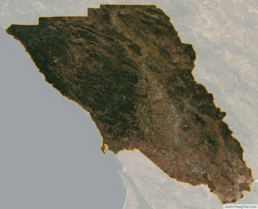
Sonoma County Satellite Map
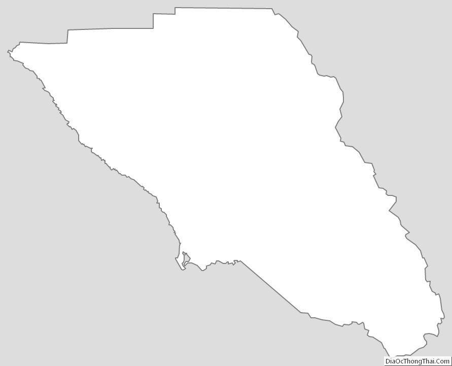
Sonoma County Outline Map
See also
Map of California State and its subdivision:- Alameda
- Alpine
- Amador
- Butte
- Calaveras
- Colusa
- Contra Costa
- Del Norte
- El Dorado
- Fresno
- Glenn
- Humboldt
- Imperial
- Inyo
- Kern
- Kings
- Lake
- Lassen
- Los Angeles
- Madera
- Marin
- Mariposa
- Mendocino
- Merced
- Modoc
- Mono
- Monterey
- Napa
- Nevada
- Orange
- Placer
- Plumas
- Riverside
- Sacramento
- San Benito
- San Bernardino
- San Diego
- San Francisco
- San Joaquin
- San Luis Obispo
- San Mateo
- Santa Barbara
- Santa Clara
- Santa Cruz
- Shasta
- Sierra
- Siskiyou
- Solano
- Sonoma
- Stanislaus
- Sutter
- Tehama
- Trinity
- Tulare
- Tuolumne
- Ventura
- Yolo
- Yuba
- Alabama
- Alaska
- Arizona
- Arkansas
- California
- Colorado
- Connecticut
- Delaware
- District of Columbia
- Florida
- Georgia
- Hawaii
- Idaho
- Illinois
- Indiana
- Iowa
- Kansas
- Kentucky
- Louisiana
- Maine
- Maryland
- Massachusetts
- Michigan
- Minnesota
- Mississippi
- Missouri
- Montana
- Nebraska
- Nevada
- New Hampshire
- New Jersey
- New Mexico
- New York
- North Carolina
- North Dakota
- Ohio
- Oklahoma
- Oregon
- Pennsylvania
- Rhode Island
- South Carolina
- South Dakota
- Tennessee
- Texas
- Utah
- Vermont
- Virginia
- Washington
- West Virginia
- Wisconsin
- Wyoming