Virginia Beach is an independent city located on the southeastern coast of the Commonwealth of Virginia in the United States. The population was 459,470 at the 2020 census. Although mostly suburban in character, it is the most populous city in the Commonwealth of Virginia, fifth-most populous city in the Mid-Atlantic, ninth-most populous city in the Southeast and the 42nd-most populous city in the U.S. Located on the Atlantic Ocean at the mouth of the Chesapeake Bay, Virginia Beach is the largest city in the Hampton Roads metropolitan area. This area, known as “America’s First Region”, also includes the independent cities of Chesapeake, Hampton, Newport News, Norfolk, Portsmouth, and Suffolk, as well as other smaller cities, counties, and towns of Hampton Roads.
Virginia Beach is a resort city with miles of beaches and hundreds of hotels, motels, and restaurants along its oceanfront. Every year the city hosts the East Coast Surfing Championships as well as the Something in the Water music festival, It is also home to several state parks, several long-protected beach areas, military bases, a number of large corporations, Virginia Wesleyan University and Regent University, the international headquarters and site of the television broadcast studios for Christian Broadcasting Network (CBN), Edgar Cayce’s Association for Research and Enlightenment, and numerous historic sites. Near the point where the Chesapeake Bay and the Atlantic Ocean meet, Cape Henry was the site of the first landing of the English colonists, who eventually settled in Jamestown, on April 26, 1607.
The city is listed in the Guinness Book of Records as having the longest pleasure beach in the world. It is located at the southern end of the Chesapeake Bay Bridge-Tunnel, which was the world’s longest bridge-tunnel complex until the Hong Kong-Zhuhai-Macau Bridge opened in 2018.
| Name: | Virginia Beach City |
|---|---|
| FIPS code: | 51-810 |
| State: | Virginia |
| Land Area: | 244.72 sq mi (633.83 km²) |
| Population Density: | 1,877.53/sq mi (724.92/km²) |
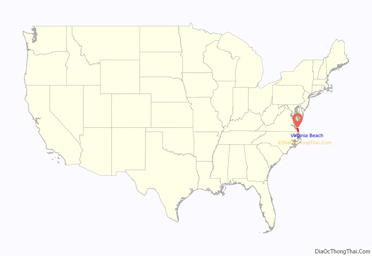
Virginia Beach City location map. Where is Virginia Beach City?
History
The Chesepian were the historic indigenous people of the area now known as Tidewater in Virginia at the time of European encounter. Little is known about them but archeological evidence suggests they may have been related to the Carolina Algonquian, or Pamlico people. They would have spoken one of the Algonquian languages. These were common among the numerous tribes of the coastal area, who made up the loose Powhatan Confederacy, numbering in the tens of thousands in population. The Chesepian occupied an area which is now defined as the independent cities of Norfolk, Portsmouth, Chesapeake, and Virginia Beach.
In 1607, after a voyage of 144 days, three ships headed by Captain Christopher Newport, and carrying 105 men and boys, made their first landfall in the New World on the mainland, where the southern mouth of the Chesapeake Bay meets the Atlantic Ocean. They named it Cape Henry, after Henry Frederick, Prince of Wales, the eldest son of King James I of England. These English colonists of the Virginia Company of London moved on from this area, as they were under orders to seek a site further inland, which would be more sheltered from ships of competing European countries. They created their first permanent settlement on the north side of the James River at Jamestown.
Adam Thoroughgood (1604–1640) of King’s Lynn, Norfolk, England is one of the earliest Englishmen to settle in this area, which was developed as Virginia Beach. At the age of 18, he had contracted as an indentured servant to pay for passage to the Virginia Colony in the hopes of bettering his life. He earned his freedom after several years and became a leading citizen of the area. In 1629, he was elected to the House of Burgesses for Elizabeth Cittie [sic], one of four “cities” (or incorporations) which were subdivided areas established in 1619.
In 1634, the Colony was divided into the original eight shires of Virginia, soon renamed as counties. Thoroughgood is credited with using the name of his home in England when helping name “New Norfolk County” in 1637. The following year, New Norfolk County was split into Upper Norfolk County (soon renamed Nansemond County) and Lower Norfolk County. Thoroughgood resided after 1634 was along the Lynnhaven River, named for his home in England.
Lower Norfolk County was large when first organized, defined as from the Atlantic Ocean west past the Elizabeth River, encompassing the entire area now within the modern cities of Portsmouth, Norfolk, Chesapeake, and Virginia Beach. It attracted many entrepreneurs, including William Moseley with his family in 1648. Belonging to the Merchant Adventurers Guild of London, he immigrated from Rotterdam of the Netherlands, where he had been in international trade. He settled on land on the north side of the Elizabeth River, east of what developed as Norfolk.
Following the increased settlement, in 1691 Lower Norfolk County was divided to form Norfolk and Princess Anne counties. Princess Anne, the easternmost county in South Hampton Roads, extended from Cape Henry at the mouth of the Chesapeake Bay, south to what became the border of the North Carolina colony. It included all of the area fronting the Atlantic Ocean. Princess Anne County was known as a jurisdiction from 1691 to 1963, over 250 years.
In the early centuries, this area was rural and developed for plantation agriculture. In the late 19th century, the small resort area of Virginia Beach developed in Princess Anne County after the 1883 arrival of rail service to the coast. The Virginia Beach Hotel was opened and operated by the Norfolk and Virginia Beach Railroad and Improvement Company at the oceanfront, near the tiny community of Seatack. The hotel was foreclosed and the railroad was reorganized in 1887. The hotel was upgraded and reopened in 1888 as the Princess Anne Hotel.
In 1891, guests at the new hotel watched the wreck and rescue efforts of the United States Life-Saving Service for the Norwegian bark Dictator. The ship’s figurehead, which washed up on the beach several days later, was erected as a monument to the victims and rescuers. It stood along the oceanfront for more than 50 years. In the 21st century, it inspired the pair of matching Norwegian Lady Monuments, sculpted by Ørnulf Bast and installed in Virginia Beach and Moss, Norway.
The resort initially depended on railroad and electric trolley service. The completion of Virginia Beach Boulevard in 1922, which extended from Norfolk to the oceanfront, opened the route for automobiles, buses, and trucks. The passenger rail service to the oceanfront was eventually discontinued as traffic increased by vehicles. The growing resort of Virginia Beach became an incorporated town in 1906. Over the next 45 years, Virginia Beach continued to grow in popularity as a seasonal vacation spot. The casinos were replaced by amusement parks and family-oriented attractions. In 1927 The Cavalier Hotel opened and became a popular vacation spot.
Virginia Beach gained status as an independent city in 1952, although ties remained between it and Princess Anne County. In 1963, after voters in the two jurisdictions passed a supporting referendum, and with the approval of the Virginia General Assembly, the two political subdivisions were consolidated as a new, much larger independent city, retaining the better-known name of the Virginia Beach resort.
The Alan B. Shepard Civic Center (“The Dome”), a significant building in the city’s history because of the many famous musical acts played there, was constructed in 1958, and was dedicated to the career of former Virginia Beach resident and astronaut Alan Shepard. As the area changed, the Dome was frequently used as a bingo hall. The building was razed in 1994 to make room for a municipal parking lot and potential future development.
Recent history
Real estate, defense, and tourism are major sectors of the Virginia Beach economy. Local public and private groups have maintained a vested interest in real-estate redevelopment, resulting in a number of joint public-private projects, such as commercial parks. Examples of the public-private development include the Virginia Beach Convention Center, the Oceanfront Hilton Hotel, and the Virginia Beach Town Center. The city assisted in financing the project through the use of tax increment financing: creating special tax districts and constructing associated street and infrastructure to support the developments. The Town Center opened in 2003, with related construction continuing. The Convention Center opened in 2005.
The city has begun to run out of clear land available for new construction north of the Green Line, an urban growth boundary dividing the urban northern and rural southern sections of the city. Infill and development of residential neighborhoods has placed a number of operating constraints on Naval Air Station Oceana, a major fighter jet base for the U.S. Navy. While the airbase enjoys wide support from Virginia Beach at large, the Pentagon Base Realignment and Closure commission has proposed closure of Oceana within the next decade. In 2012 a Navy jet that took off from Oceana experienced engine failure and crashed into an apartment complex.
This land crunch led to floodplain development. During Hurricane Matthew, the heavy rainfall flooded over 2000 homes and left some neighborhoods with standing water for days. Given the rising risks of flooding due to climate change and the impetus of the hurricane damage, the city rejected several further development proposals. This rejection was significant from two perspectives. First, cities reject building very rarely, demonstrating the shift in public perception. Second, these rejections led to lawsuits by the developers. The rejection of these lawsuits in the courts provides precedent for other sorts of local climate change adaptation efforts in the future. Discussing the matter, Mayor Dyer noted, “It’s a confrontation with reality. Not everybody’s going to be happy.”
On May 31, 2019, a mass shooting occurred at a municipal government building in Virginia Beach. A former employee entered the building and shot indiscriminately, killing 12 people and injuring four others before dying from a gunshot wound fired by responding officers.
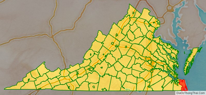
Virginia Beach City Road Map
Geography
Virginia Beach is located at 36°51′02″N 75°58′40″W / 36.8506°N 75.9779°W / 36.8506; -75.9779 (Virginia Beach).
According to the United States Census Bureau, the city has a total area of 497 square miles (1,290 km), of which 249 square miles (640 km) is land and 248 square miles (640 km) (49.9%) is water. It is the largest city in Virginia by total area and third-largest city by land area. The average elevation is 12 feet (3.7 m) above sea level. A major portion of the city drains to the Chesapeake Bay by way of the Lynnhaven River and its tributaries.
The city is located at the southeastern corner of Virginia in the Hampton Roads area bordering the Atlantic Ocean. The Hampton Roads Metropolitan Statistical Area (officially known as the Virginia Beach-Norfolk-Newport News, VA-NC MSA) is the 37th largest in the United States, with a total population of 1,707,639. The area includes the Virginia cities of Norfolk, Virginia Beach, Chesapeake, Hampton, Newport News, Poquoson, Portsmouth, Suffolk, Williamsburg, and the counties of Gloucester, Isle of Wight, James City, Mathews, Surry, and York, as well as the North Carolina county of Currituck. While Virginia Beach is the most populated city within the MSA, it actually currently functions more as a suburb. The city of Norfolk is recognized as the central business district, while the Virginia Beach oceanside resort district and Williamsburg are primarily centers of tourism.
Additionally, Virginia Beach is 19 miles (31 km) east of Norfolk, 24 miles (39 km) northeast of Chesapeake, 107 miles (172 km) southeast of Richmond, the state capitol, and 200 miles (320 km) northeast of Raleigh, North Carolina
Neighborhoods
When the modern city of Virginia Beach was created in 1963, by the consolidation of the 253 square miles (660 km) Princess Anne County with the 2 square miles (5.2 km) City of Virginia Beach, the newly larger city was divided into seven boroughs: Bayside, Blackwater, Kempsville, Lynnhaven, Princess Anne, Pungo, and Virginia Beach.
Virginia Beach has many distinctive communities and neighborhoods within its boundaries, including: Alanton, Aragona Village, the largest sub-division in Tidewater when completed, Bay Colony, Bayside, Cape Henry, Chesapeake Beach, Croatan Beach, Great Neck Point, Green Run, Kempsville, Lago Mar, Larkspur, London Bridge, Lynnhaven, Newtown, The North End, Oceana, Ocean Park, Pembroke Manor, Princess Anne, Pungo, Red Mill Commons, Sandbridge, Shadowlawn, Thalia, and Thoroughgood.
Climate
The climate of Virginia Beach is humid subtropical (Köppen: Cfa). For the Trewartha update system the climate is the northern limit of Cf (subtropical) which corresponds to the ecology of the area, which struggles to withstand the cooler temperatures further north or inland.
Winters are cool and snowfall is light. Summers are hot and humid. The official weather statistics are recorded at Norfolk International Airport on the extreme northwestern border of Virginia Beach. The mean annual temperature is 59.6 °F (15.3 °C), with an average annual snowfall of 5.8 inches (150 mm) at the airport to around 3.0 inches (76 mm) in the southeastern corner around Back Bay. Average annual precipitation (the large majority rainfall) is high, ranging between 47 inches (1,200 mm) at the airport to over 50 inches (1,300 mm) per year at Back Bay. The wettest season is summer, specifically July to early September, with August the single wettest month, averaging over 5.5 inches of rain. From October to June, average monthly precipitation is remarkably consistent, ranging between 3.1 and 3.7 inches.
The highest recorded temperature to date was 105 °F (41 °C) in July 2010, and the lowest recorded temperature was −3 °F (−19 °C) in January 1985, both being recorded at Norfolk International Airport. The coldest daily maximum on record was 12 °F (−11 °C) in December 1917, whereas the 1991–2020 normals had a coldest maximum average of 29 °F (−2 °C). This means that in spite of the mild normals, most years record at least one ice day, with rare exceptions. Summer nights are sometimes really hot. The all-time record low is 84 °F (29 °C) from July 1942, while a normal year’s warmest night averages 80 °F (27 °C).
Additionally, the geographic location of the city, with respect to the principal storm tracks, is especially favorable which is why it has earned the reputation as a vacation destination. It is south of the average path of storms originating in the higher latitudes, and north of the usual tracks of hurricanes and other major tropical storms, with the exception of Hurricane Isabel in 2003. Because of the moderating effects of the Chesapeake Bay and the Atlantic Ocean, Virginia Beach is the northernmost location on the east coast in which many species of plants (both subtropical and tropical) will reliably grow. Spanish moss, for example is near the northernmost limit of its natural range at First Landing State Park, and is the most northerly location where it is widespread. Other plants like the Windmill Palm, Sabal palmetto, Butia odorata (in protected locations), and Oleander are successfully grown here while they succumb to the colder winter temperatures to the north and inland to the west. The hardiness zone is 8b along the coast and in Urban areas, and 8a inland and to the northwest.
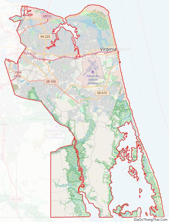
Virginia Beach City Topographic Map
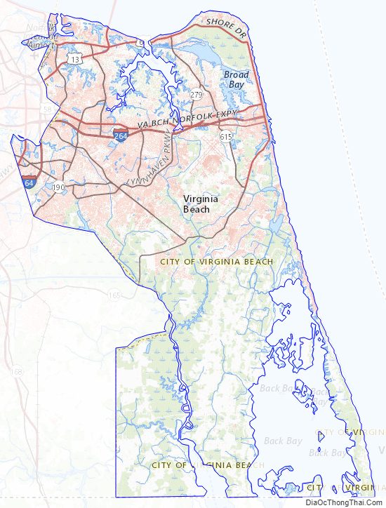
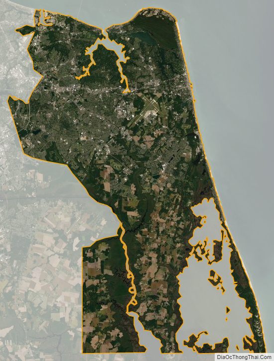
Virginia Beach City Satellite Map
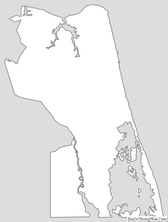
Virginia Beach City Outline Map
See also
Map of Virginia State and its subdivision:- Accomack
- Albemarle
- Alexandria
- Alleghany
- Amelia
- Amherst
- Appomattox
- Arlington
- Augusta
- Bath
- Bedford
- Bedford City
- Bland
- Botetourt
- Bristol
- Brunswick
- Buchanan
- Buckingham
- Buena Vista
- Campbell
- Caroline
- Carroll
- Charles City
- Charlotte
- Charlottesville
- Chesapeake
- Chesterfield
- Clarke
- Clifton Forge City
- Colonial Heights
- Covington
- Craig
- Culpeper
- Cumberland
- Danville
- Dickenson
- Dinwiddie
- Emporia
- Essex
- Fairfax
- Fairfax City
- Falls Church
- Fauquier
- Floyd
- Fluvanna
- Franklin
- Frederick
- Fredericksburg
- Galax
- Giles
- Gloucester
- Goochland
- Grayson
- Greene
- Greensville
- Halifax
- Hampton
- Hanover
- Harrisonburg
- Henrico
- Henry
- Highland
- Hopewell
- Isle of Wight
- James City
- King and Queen
- King George
- King William
- Lancaster
- Lee
- Lexington
- Loudoun
- Louisa
- Lunenburg
- Lynchburg
- Madison
- Manassas
- Manassas Park
- Martinsville
- Mathews
- Mecklenburg
- Middlesex
- Montgomery
- Nelson
- New Kent
- Newport News
- Norfolk
- Northampton
- Northumberland
- Norton
- Nottoway
- Orange
- Page
- Patrick
- Petersburg
- Pittsylvania
- Poquoson
- Portsmouth
- Powhatan
- Prince Edward
- Prince George
- Prince William
- Pulaski
- Radford
- Rappahannock
- Richmond
- Roanoke
- Roanoke City
- Rockbridge
- Rockingham
- Russell
- Salem
- Scott
- Shenandoah
- Smyth
- Southampton
- Spotsylvania
- Stafford
- Staunton
- Suffolk
- Surry
- Sussex
- Tazewell
- Virginia Beach
- Warren
- Washington
- Waynesboro
- Westmoreland
- Williamsburg
- Winchester
- Wise
- Wythe
- York
- Alabama
- Alaska
- Arizona
- Arkansas
- California
- Colorado
- Connecticut
- Delaware
- District of Columbia
- Florida
- Georgia
- Hawaii
- Idaho
- Illinois
- Indiana
- Iowa
- Kansas
- Kentucky
- Louisiana
- Maine
- Maryland
- Massachusetts
- Michigan
- Minnesota
- Mississippi
- Missouri
- Montana
- Nebraska
- Nevada
- New Hampshire
- New Jersey
- New Mexico
- New York
- North Carolina
- North Dakota
- Ohio
- Oklahoma
- Oregon
- Pennsylvania
- Rhode Island
- South Carolina
- South Dakota
- Tennessee
- Texas
- Utah
- Vermont
- Virginia
- Washington
- West Virginia
- Wisconsin
- Wyoming