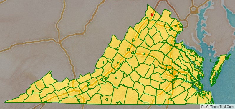
Winchester is the northwesternmost independent city in the Commonwealth of Virginia. It is the county seat of Frederick County, although the two are separate jurisdictions. The Bureau of Economic Analysis combines the city of Winchester with surrounding Frederick County for statistical purposes. As of the 2020 census, the city’s population was 28,120.
Winchester is the principal city of the Winchester, Virginia–West Virginia, metropolitan statistical area, which is a part of the Washington-Baltimore combined statistical area. Winchester is home to Shenandoah University and the Museum of the Shenandoah Valley.
| Name: | Winchester City |
|---|---|
| FIPS code: | 51-840 |
| State: | Virginia |
| Founded: | 1744 |
| Total Area: | 9.21 sq mi (23.86 km²) |
| Land Area: | 9.19 sq mi (23.81 km²) |
| Total Population: | 28,120 |
| Population Density: | 3,100/sq mi (1,200/km²) |
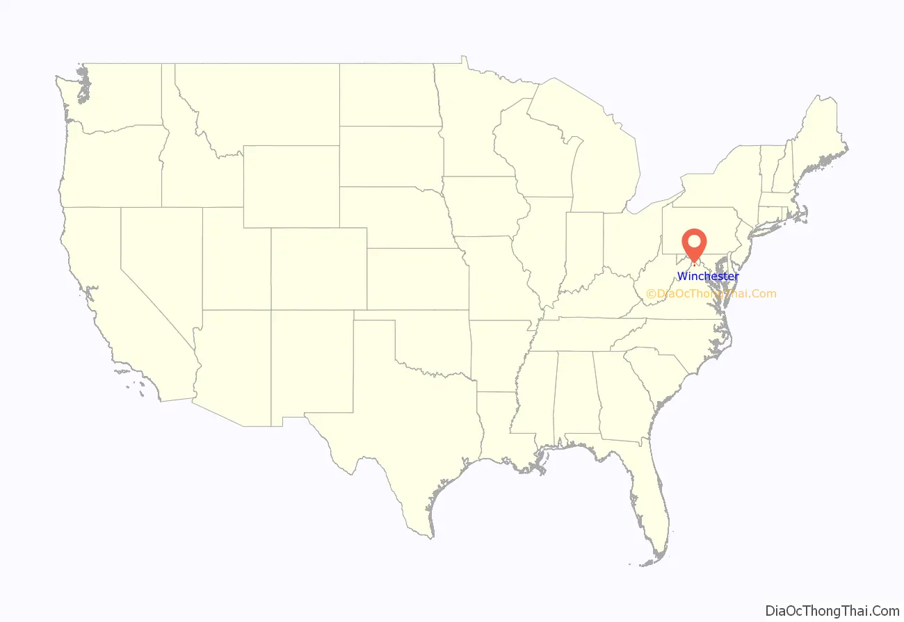
Winchester City location map. Where is Winchester City?
History
Native Americans
Indigenous peoples lived along the waterways of present-day Virginia for thousands of years before European contact. Archeological, linguistic and anthropological studies have provided insights into their cultures. Though little is known of specific tribal movements before European contact, the Shenandoah Valley area, considered a sacred common hunting ground, appears by the 17th century to have been controlled mostly by the local Iroquoian-speaking groups, including the Senedo and Sherando.
The Algonquian-speaking Shawnee began to challenge the Iroquoians for the hunting grounds later in that century. The explorers Batts and Fallam in 1671 reported the Shawnee were contesting with the Iroquoians for control of the valley and were losing. During the later Beaver Wars, the powerful Iroquois Confederacy from New York (particularly Seneca from the western part of the territory) subjugated all tribes in the frontier region west of the Fall Line.
By the time European settlers arrived in the Shenandoah Valley around 1729, the Shawnee were the principal occupants in the area around Winchester. During the first decade of white settlement, the valley was also a conduit and battleground in a bloody intertribal war between the Seneca and allied Algonquian Lenape from the north, and their distant traditional enemies, the Siouan Catawba in the Carolinas. The Iroquois Six Nations finally ceded their nominal claim to the Shenandoah Valley at the Treaty of Lancaster (1744). The treaty also established the right of colonists to use the Indian Road, later known as the Great Wagon Road.
The father of the historical Shawnee chief Cornstalk had his court at Shawnee Springs, near today’s Cross Junction, Virginia, until 1754. In 1753, on the eve of the French and Indian War (Seven Years’ War), messengers came to the Shawnee from tribes further west, inviting them to leave the Valley and cross the Alleghenies, which they did the following year. The Shawnee settled for some years in the Ohio Country before being forced by the US government under Indian Removal in the 1830s to remove to Indian Territory.
Winchester had a notable role as a frontier city in those early times. The Governor of Virginia, as well as the young military commander George Washington, met in the town with their Iroquois allies (called the “Half-Kings”), to coordinate maneuvers against the French and their Native American allies during the French and Indian War.
European exploration
French Jesuit expeditions may have first entered the valley as early as 1606, as the explorer Samuel de Champlain made a crude map of the area in 1632. The first confirmed exploration of the northern valley was by the explorer John Lederer, who viewed the region from the current Fauquier and Warren County line on August 26, 1670. In 1705 the Swiss explorer Louise Michel and in 1716 Governor Alexander Spotswood did more extensive mapping and surveying.
In the late 1720s, Governor William Gooch promoted settlement by issuing large land grants. Robert “King” Carter, manager of the Lord Fairfax proprietorship, acquired 200,000 acres (810 km). This combination of events directly precipitated an inrush of settlers from Pennsylvania and New York, made up of a blend of Quakers and German and Scots-Irish homesteaders, many of them new immigrants. The Scots-Irish comprised the most numerous group of immigrants from the British Isles before the American Revolutionary War.
European settlement
The settlement of Winchester began as early as 1729, when Quakers such as Abraham Hollingsworth migrated up (south) the Great Valley along the long-traveled Indian Path (later called the Great Wagon Road by the colonists) from Pennsylvania. He and others began to homestead on old Shawnee campgrounds. Tradition holds that the Quakers purchased several tracts on Apple-pie Ridge from the natives, who did not disturb those settlements.
The first German settler appears to have been Jost Hite in 1732, who brought ten other families, including some Scots-Irish. Though Virginia was an Anglican colony, Governor William Gooch had a tolerant policy on religion. The availability of land grants brought in many religious families, who were often given 50-acre (200,000 m) plots through the sponsorship of fellow-religious grant purchasers and speculators. As a result, the Winchester area became home to some of the oldest Presbyterian, Quaker, Lutheran and Anglican churches in the valley. The first Lutheran worship was established by Rev. John Casper Stoever Jr., and Alexander Ross established Hopewell Meeting for the Quakers. By 1736, Scots-Irish built the Opequon Presbyterian Church in Kernstown.
A legal fight erupted in 1735 when Thomas Fairfax, Sixth Lord Fairfax came to Virginia to claim his land grant. It included “all the land in Virginia between the Rappahannock and the Potomac rivers”, an old grant from King Charles II which overlapped and included Frederick County. It took some time for land titles to be cleared among early settlers.
Founding
By 1738 these settlements became known as Frederick Town. The county of Frederick was carved out of Orange County. The first government was created, consisting of a County Court as well as the Anglican Frederick Parish (for purposes of tax collection). Colonel James Wood, an immigrant from Winchester, England, was the first court clerk and had been a surveyor for Orange County, Virginia. He contracted for his own home Glen Burnie homstead around 1737, and it may have been used for early government business. Wood laid out 26 half-acre (2,000 m²) lots in 1744. The County Court held its first session on November 11, 1743, where James Wood served until 1760. Lord Fairfax, understanding that possession is 9/10ths of the law, built a home here (in present-day Clarke County) in 1748.
In February 1752, the Virginia House of Burgesses granted the fourth city charter in Virginia to ‘Winchester’ as Frederick Town was renamed after Colonel Wood’s birthplace in England. In 1754, Abraham Hollingsworth built the local residence called Abram’s Delight, which served as the first local Quaker meeting house. George Washington spent a good portion of his young life in Winchester helping survey the Fairfax land grant for Thomas Fairfax, Sixth Lord Fairfax, as well as performing surveying work for Colonel Wood. In 1758 Wood added 158 lots to the west side of town. In 1759 Thomas Lord Fairfax contributed 173 more lots to the south and east.
French and Indian War
General Edward Braddock’s expeditionary march to Fort Duquesne crossed through this area in 1755 on the way to Fort Cumberland. Knowing the area well from work as a surveyor, George Washington accompanied General Braddock as his aide-de-camp. Resident Daniel Morgan joined Braddock’s Army as a wagoner on its march to Pennsylvania.
In 1756, on land granted by James Wood, Colonel George Washington designed and began constructing Fort Loudoun, which ultimately covered 0.955 acres (3,860 m) in present-day downtown Winchester on North Loudoun Street. Fort Loudoun was occupied and manned with guns until the start of the American Revolutionary War.
During this era, a jail was built in Winchester. It occasionally held Quakers from many parts of Virginia who protested the French and Indian War and refused to pay taxes to the Anglican parish. While their cousins in Pennsylvania dominated politics there, Virginia was an Anglican colony and did not tolerate pacifism well. The strong Quaker tradition of pacifism against strong Virginia support for this war and the next, led to long-term stifling of the Quaker population. Winchester became a gateway to Quaker settlements further west; by the mid-19th century, the Quaker population was a small minority here.
During the war in 1758, at the age of 26, Colonel George Washington was elected to represent Frederick County to the House of Burgesses. Daniel Morgan later served as a ranger protecting the borderlands of Virginia against Indian raids, returning to Winchester in 1759. Following the war, from 1763 to 1774 Daniel Morgan served in Captain Ashby’s company and defended Virginia against Pontiac’s Rebellion and Shawnee Indians in the Ohio valley (that part now in West Virginia).
Revolutionary War
During the Revolutionary War, the Virginia House of Burgesses chose local resident and French and Indian War veteran Daniel Morgan to raise a company of militia to support General George Washington’s efforts during the Siege of Boston. He led the 96 men of “Morgan’s Sharpshooters” from Winchester on July 14, 1775, and marched to Boston in 21 days. Morgan, Wood, and others also performed duties in holding captured prisoners of war, particularly Hessian soldiers.
Hessian soldiers were known to walk to the high ridge north and west of town, where they could purchase and eat apple pies made by the Quakers. The ridge became affectionately known as Apple Pie Ridge. The Ridge Road built before 1751 leading north from town was renamed Apple Pie Ridge Road. The local farmers found booming business in feeding the Virginia Militia and fledgling volunteer American army.
Following the war, the town’s first newspapers, The Gazette and The Centinel, were established. Daniel Morgan continued his public service, being elected to one term in the U.S. House of Representatives (1797–1799).
Civil War
Winchester and the surrounding area were the site of numerous battles during the American Civil War, as the Confederate and Union armies strove to control that portion of the Shenandoah Valley. Seven major battlefields are in the original Frederick County:
Within the city of Winchester:
- The First Battle of Kernstown, March 23, 1862
- The First Battle of Winchester, May 25, 1862
- The Second Battle of Winchester, June 13–15, 1863
- The Second Battle of Kernstown, July 24, 1864
- The Third Battle of Winchester, September 19, 1864
Near the city of Winchester:
- The Battle of Cool Spring at Snicker’s Gap, July 17–18, 1864
- The Battle of Berryville, September 3–4, 1864
- The Battle of Belle Grove (or Cedar Creek), October 19, 1864
Winchester was a key strategic position for the Confederate States Army during the war. It was an important operational objective in Gen Joseph E. Johnston’s and Col Thomas J. “Stonewall” Jackson’s defense of the Shenandoah Valley in 1861, Jackson’s Valley Campaign of 1862, the Gettysburg Campaign of 1863, and the Valley Campaigns of 1864. Including minor cavalry raids and patrols, and occasional reconnaissances, historians claim that Winchester changed hands as many as 72 times and 13 times in one day. Battles raged along Main Street at points in the war. Union General Sheridan and Stonewall Jackson located their headquarters just one block apart at times.
At the north end of the lower Shenandoah Valley, Winchester was a base of operations for major Confederate invasions into the Northern United States. At times the attacks threatened the capital of Washington, D.C. The town served as a central point for troops conducting major raids against the Baltimore and Ohio Railroad, Chesapeake and Ohio Canal, and turnpike and telegraph paths along those routes and the Potomac River Valley. For instance, in 1861, Stonewall Jackson removed 56 locomotives and over 300 railroad cars, along with miles of track, from the B&O Railroad. His attack closed down the B&O’s main line for ten months. Much of the effort to transport this equipment by horse and carriage centered in Winchester.
During the war, Winchester was occupied by the Union Army for four major periods:
- Major General Nathaniel Banks – (March ? May 12 to 25, 1862, and June 4 to September 2, 1862)
- Major General Robert Milroy – (December 24, 1862, to June 15, 1863)
- Major General Philip Sheridan – (September 19, 1864, to February 27, 1865)
- Major General Winfield Scott Hancock – February 27, 1865, to June 27, 1865
Major General Sheridan raided up the valley from Winchester, where his forces destroyed “2,000 barns filled with grain and implements, not to mention other outbuildings, 70 mills filled with wheat and flour” and “numerous head of livestock,” to lessen the area’s ability to supply the Confederates.
Numerous local men served with the Confederate Army, mostly as troops. Dr. Hunter McGuire was Chief Surgeon of the Second “Jackson’s” Corps of the Army of Northern Virginia. He laid the foundations for the future Geneva conventions regarding the treatment of medical doctors during warfare. Winchester served as a major center for Confederate medical operations, particularly after the Battle of Sharpsburg in 1862 and the Battle of Gettysburg in 1863.
Among those who took part in battles at Winchester were future U.S. presidents McKinley and Hayes, both as officers in the Union IX Corps.
Today, Winchester has extensive resources for Civil War enthusiasts. For instance, there are remains of several Civil War-era forts:
- Fort Jackson (a.k.a. Fort Garibaldi, Main Fort, Fort Milroy, Battery No. 2)
- Fort Alabama (a.k.a. Star Fort, Battery No. 3)
- Fort Collier (a.k.a. Battery No. 10)
- Louisiana Heights (a.k.a. the combination of West Fort or Battery No.5 and Battery No. 6)
- Bower’s Hill (a.k.a. Battery No. 1)
Jubal Early Drive, which curves south of downtown Winchester, was the central location for many of the battles.
The United States assigned military presence to Winchester and other parts of the South during Reconstruction after the war. Winchester was part of the First Military District, commanded by Major General John Schofield. This period lasted until January 26, 1870.
20th century
Winchester was the first city south of the Potomac River to install electric light. In 1917 the Winchester and Western Railroad connected Winchester with Rock Enon Springs, moving both vacationers and supplies to the resort that is now Camp Rock Enon with far greater speed. Winchester is the location of the bi-annual N-SSA national competition, keeping the tradition of Civil War era firearms alive. A three-block section of downtown Loudoun Street was closed to vehicular traffic in the 1970s and is a popular pedestrian area featuring many boutiques and cafés. The street was repaved with brick and landscaped in 2013. Apple Blossom Mall opened in 1982.
In 1983, a tire dump in the area containing over seven million tires burned for nine months, polluting nearby areas with lead and arsenic. The location was cleaned up as a Superfund project between 1983 and 2002.
Historic sites
In addition to the sites on the National Register of Historic Places, the following historic sites are in Winchester:
- Christ Church (1828)
- Museum of the Shenandoah Valley
- Old Court House Civil War Museum (1840)
- Old Town Winchester (1738)
- Opequon Presbyterian Church and Cemetery (1736)
- Red Lion Tavern (1783)
- Shenandoah Valley Military Academy (1764)
- Site of Historic Fort Loudoun (1756)
- Stonewall Cemetery (1866)
- Kurtz Building (1836)
- Winchester Confederate Cemetery
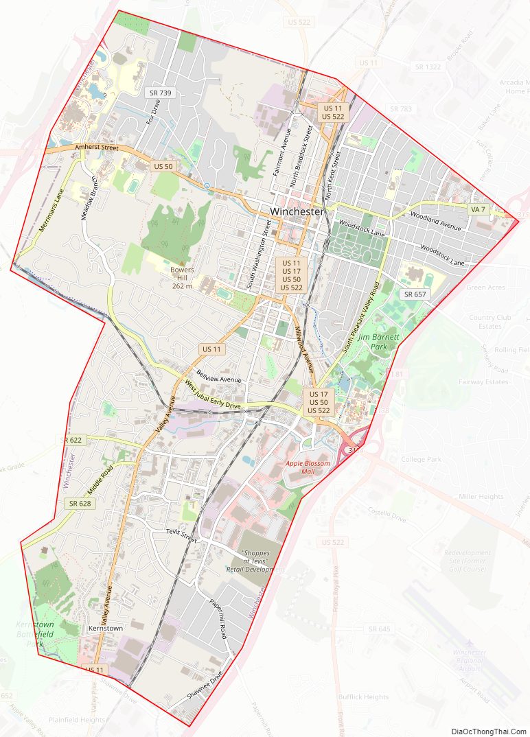
Winchester City Road Map
Geography
Winchester is located at 39°10′41″N 78°10′01″W / 39.178°N 78.167°W / 39.178; -78.167.
According to the United States Census Bureau, the city has a total area of 9.3 square miles (24 km), virtually all land.
It is in the Shenandoah Valley, located between the Blue Ridge Mountains and the Allegheny Mountains, and is 15 miles north-northeast of the northern peak of Massanutten Mountain. I-81 passes through the city, along with US 50, US 522, US 17, which ends in the city, and SR 7, which also ends in the city. The city is approximately 75 miles (121 km) to the west of Washington, D.C., 24 miles (39 km) south of Martinsburg, West Virginia, 25 miles (40 km) north of Front Royal, 118 miles (190 km) south of Harrisburg, PA and 180 miles (290 km) north of Roanoke.
Climate
The climate in this area is characterized by hot, humid summers and generally mild to cool winters. According to the Köppen Climate Classification system, Winchester has depending on which isotherm is used, either a humid continental climate or a humid subtropical climate, abbreviated “Cfa” on climate maps. The hardiness zone is 6b.
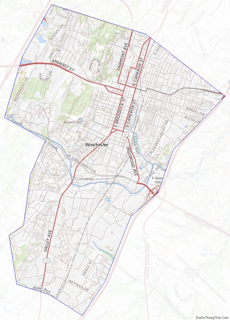
Winchester City Topographic Map
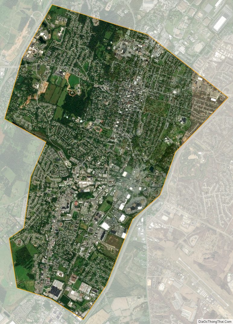
Winchester City Satellite Map
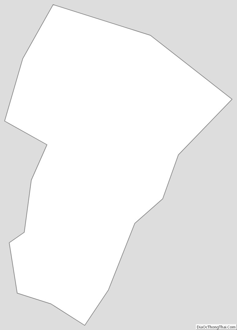
Winchester City Outline Map
See also
Map of Virginia State and its subdivision:- Accomack
- Albemarle
- Alexandria
- Alleghany
- Amelia
- Amherst
- Appomattox
- Arlington
- Augusta
- Bath
- Bedford
- Bedford City
- Bland
- Botetourt
- Bristol
- Brunswick
- Buchanan
- Buckingham
- Buena Vista
- Campbell
- Caroline
- Carroll
- Charles City
- Charlotte
- Charlottesville
- Chesapeake
- Chesterfield
- Clarke
- Clifton Forge City
- Colonial Heights
- Covington
- Craig
- Culpeper
- Cumberland
- Danville
- Dickenson
- Dinwiddie
- Emporia
- Essex
- Fairfax
- Fairfax City
- Falls Church
- Fauquier
- Floyd
- Fluvanna
- Franklin
- Frederick
- Fredericksburg
- Galax
- Giles
- Gloucester
- Goochland
- Grayson
- Greene
- Greensville
- Halifax
- Hampton
- Hanover
- Harrisonburg
- Henrico
- Henry
- Highland
- Hopewell
- Isle of Wight
- James City
- King and Queen
- King George
- King William
- Lancaster
- Lee
- Lexington
- Loudoun
- Louisa
- Lunenburg
- Lynchburg
- Madison
- Manassas
- Manassas Park
- Martinsville
- Mathews
- Mecklenburg
- Middlesex
- Montgomery
- Nelson
- New Kent
- Newport News
- Norfolk
- Northampton
- Northumberland
- Norton
- Nottoway
- Orange
- Page
- Patrick
- Petersburg
- Pittsylvania
- Poquoson
- Portsmouth
- Powhatan
- Prince Edward
- Prince George
- Prince William
- Pulaski
- Radford
- Rappahannock
- Richmond
- Roanoke
- Roanoke City
- Rockbridge
- Rockingham
- Russell
- Salem
- Scott
- Shenandoah
- Smyth
- Southampton
- Spotsylvania
- Stafford
- Staunton
- Suffolk
- Surry
- Sussex
- Tazewell
- Virginia Beach
- Warren
- Washington
- Waynesboro
- Westmoreland
- Williamsburg
- Winchester
- Wise
- Wythe
- York
- Alabama
- Alaska
- Arizona
- Arkansas
- California
- Colorado
- Connecticut
- Delaware
- District of Columbia
- Florida
- Georgia
- Hawaii
- Idaho
- Illinois
- Indiana
- Iowa
- Kansas
- Kentucky
- Louisiana
- Maine
- Maryland
- Massachusetts
- Michigan
- Minnesota
- Mississippi
- Missouri
- Montana
- Nebraska
- Nevada
- New Hampshire
- New Jersey
- New Mexico
- New York
- North Carolina
- North Dakota
- Ohio
- Oklahoma
- Oregon
- Pennsylvania
- Rhode Island
- South Carolina
- South Dakota
- Tennessee
- Texas
- Utah
- Vermont
- Virginia
- Washington
- West Virginia
- Wisconsin
- Wyoming