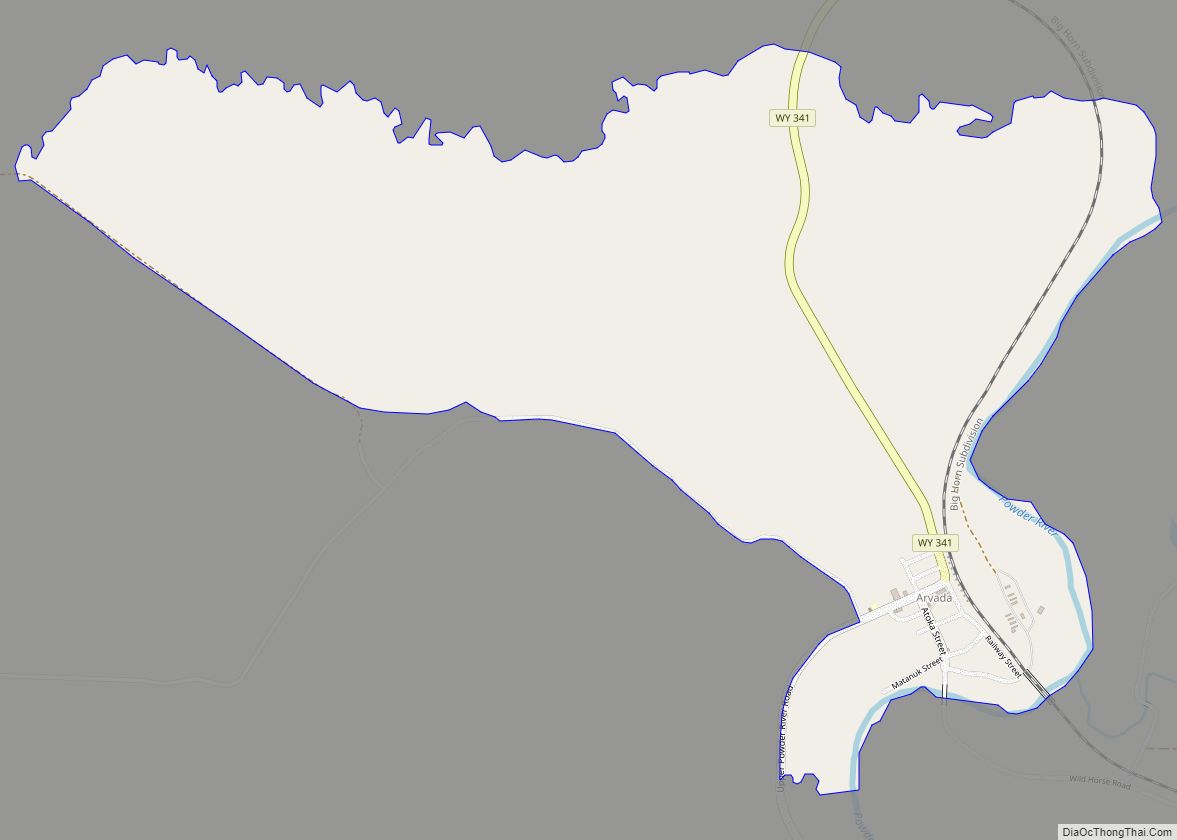
Map of Alpine town, Wyoming

Map of Alpine town, Wyoming

Alpine is a town in Lincoln County, Wyoming, United States. The population was 828 at the 2010 census. Alpine town overview: Name: Alpine town LSAD Code: 43 LSAD Description: town (suffix) State: Wyoming County: Lincoln County Elevation: 5,633 ft (1,717 m) Total Area: 1.00 sq mi (2.58 km²) Land Area: 0.99 sq mi (2.57 km²) Water Area: 0.00 sq mi (0.01 km²) Total Population: 828 Population … Read more

Map of Alpine Northwest CDP

Map of Alpine Northwest CDP

Alpine Northwest is a census-designated place (CDP) in Lincoln County, Wyoming, United States. The population was 244 at the 2010 census. Alpine Northwest CDP overview: Name: Alpine Northwest CDP LSAD Code: 57 LSAD Description: CDP (suffix) State: Wyoming County: Lincoln County Total Area: 1.4 sq mi (3.7 km²) Land Area: 1.4 sq mi (3.7 km²) Water Area: 0.0 sq mi (0.0 km²) Total Population: … Read more

Map of Alpine Northeast CDP

Map of Alpine Northeast CDP

Alpine Northeast is a census-designated place in Lincoln County, Wyoming, United States. The population was 196 at the 2010 census. Alpine Northeast CDP overview: Name: Alpine Northeast CDP LSAD Code: 57 LSAD Description: CDP (suffix) State: Wyoming County: Lincoln County Total Area: 5.0 sq mi (13.1 km²) Land Area: 5.0 sq mi (13.1 km²) Water Area: 0.0 sq mi (0.0 km²) Total Population: 196 … Read more

Map of Alcova CDP

Map of Alcova CDP

Alcova is a census-designated place (CDP) in Natrona County, Wyoming, United States. It is part of the Casper, Wyoming Metropolitan Statistical Area. The population was 34 at the 2020 census. Wyoming’s center of population is located in the small Town of Alcova. Alcova and the nearby reservoir, Alcova Lake, are popular vacation spots with many … Read more

Map of Albin town

Map of Albin town

Albin is a town in Laramie County, Wyoming, United States. It is part of the Cheyenne Metropolitan Statistical Area. The population was 181 at the 2010 census. Albin town overview: Name: Albin town LSAD Code: 43 LSAD Description: town (suffix) State: Wyoming County: Laramie County Elevation: 5,338 ft (1,627 m) Total Area: 0.15 sq mi (0.38 km²) Land Area: 0.15 sq mi … Read more

Map of Albany CDP, Wyoming

Map of Albany CDP, Wyoming

Albany is a census-designated place (CDP) in Albany County, Wyoming, United States. The population was 55 at the 2010 census. Albany CDP overview: Name: Albany CDP LSAD Code: 57 LSAD Description: CDP (suffix) State: Wyoming County: Albany County Elevation: 8,327 ft (2,538 m) Total Area: 11.0 sq mi (28 km²) Land Area: 11.0 sq mi (28 km²) Water Area: 0 sq mi (0 km²) Total Population: … Read more

Map of Afton town, Wyoming

Map of Afton town, Wyoming

Afton is a town in Lincoln County, Wyoming, United States. The population was 1,911 at the 2010 census. Afton is home to the world’s largest arch made of elk antlers. Spanning 75 feet (23 m) across the four lanes of U.S. Highway 89, the arch consists of 3,011 elk antlers and weighs 15 tons. Afton town … Read more

Map of Auburn CDP, Wyoming

Map of Auburn CDP, Wyoming

Auburn is a census-designated place (CDP) in Lincoln County, Wyoming, United States. As of the 2010 census, the CDP population was 328. The first settlement at Auburn was made in 1879. Auburn CDP overview: Name: Auburn CDP LSAD Code: 57 LSAD Description: CDP (suffix) State: Wyoming County: Lincoln County Elevation: 6,053 ft (1,845 m) Total Area: 2.1 sq mi … Read more

Map of Atlantic City CDP, Wyoming

Map of Atlantic City CDP, Wyoming

Atlantic City is a census-designated place (CDP) in Fremont County, Wyoming, United States. The population was 37 at the 2010 census. The community is a small mining settlement in a gulch near South Pass in southwestern Wyoming. It was founded as a mining camp following the 1867 gold rush in the region. The town declined … Read more

Map of Brookhurst CDP

Map of Brookhurst CDP

Brookhurst is a census-designated place (CDP) in Natrona County, Wyoming, United States. It is part of the Casper, Wyoming Metropolitan Statistical Area. The population was 185 at the 2010 census. Brookhurst CDP overview: Name: Brookhurst CDP LSAD Code: 57 LSAD Description: CDP (suffix) State: Wyoming County: Natrona County Elevation: 5,118 ft (1,560 m) Total Area: 0.7 sq mi (2 km²) … Read more

Map of Boulder CDP, Wyoming

Map of Boulder CDP, Wyoming

Boulder is a census-designated place (CDP) in Sublette County, Wyoming, United States. The population was 170 at the 2010 census. Boulder CDP overview: Name: Boulder CDP LSAD Code: 57 LSAD Description: CDP (suffix) State: Wyoming County: Sublette County Elevation: 7,018 ft (2,139 m) Total Area: 1.9 sq mi (5 km²) Land Area: 1.9 sq mi (5 km²) Water Area: 0.0 sq mi (0 km²) Total Population: … Read more

Map of Boulder Flats CDP

Map of Boulder Flats CDP

Boulder Flats is a census-designated place (CDP) in Fremont County, Wyoming, United States. The population was 408 at the 2010 census. Boulder Flats CDP overview: Name: Boulder Flats CDP LSAD Code: 57 LSAD Description: CDP (suffix) State: Wyoming County: Fremont County Elevation: 5,587 ft (1,703 m) Total Area: 18.2 sq mi (47.2 km²) Land Area: 18.2 sq mi (47.2 km²) Water Area: 0.0 sq mi … Read more