Map of Yalaha CDP

Map of Yalaha CDP

Yalaha is an unincorporated area and census-designated place (CDP) in Lake County, Florida, United States. The population was 1,364 at the 2010 census, up from 1,175 at the 2000 census. It is part of the Orlando–Kissimmee Metropolitan Statistical Area. Yalaha CDP overview: Name: Yalaha CDP LSAD Code: 57 LSAD Description: CDP (suffix) State: Florida County: … Read more

Map of Wright CDP

Map of Wright CDP, Florida

Wright is a census-designated place (CDP) in Okaloosa County, Florida, United States. The population was 23,127 at the 2010 United States Census. It is part of the Fort Walton Beach–Crestview–Destin Metropolitan Statistical Area. Wright CDP overview: Name: Wright CDP LSAD Code: 57 LSAD Description: CDP (suffix) State: Florida County: Okaloosa County Elevation: 43 ft (13 m) Total … Read more

Map of Worthington Springs town

Map of Worthington Springs town

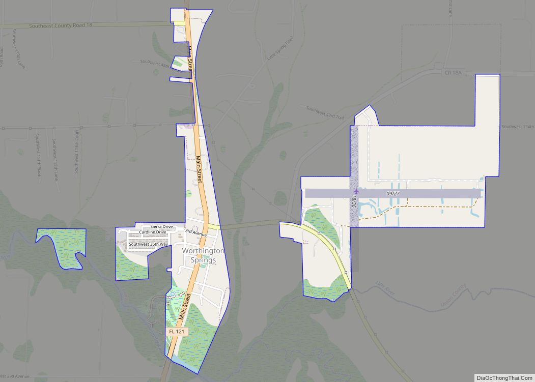
Worthington Springs is a spring and town in Union County, Florida, United States. The population was 181 at the 2010 census. According to the U.S. Census Bureau’s 2018 estimates, the town had a population of 380. Worthington Springs town overview: Name: Worthington Springs town LSAD Code: 43 LSAD Description: town (suffix) State: Florida County: Union … Read more

Map of Yulee CDP

Map of Yulee CDP

Yulee is a Census County Division (CCD) in Nassau County, Florida, United States. It is situated in northeastern Florida, directly south of the Florida/Georgia state line (St. Marys River), and 24 miles north of downtown Jacksonville, Florida. The CCD’s population is currently 36,742 as of a 2021 U.S. Census Bureau survey. Yulee is part of … Read more

Map of Yeehaw Junction CDP

Map of Yeehaw Junction CDP

Yeehaw Junction is a census-designated place (CDP) in Osceola County, Florida, United States. As of the 2010 census, it had a population of 240. The area was confused with Buenaventura Lakes CDP in the 2000 census, and the correct data for the area was not recorded. Yeehaw Junction is part of the Orlando–Kissimmee Metropolitan Statistical … Read more

Map of Yankeetown town

Map of Yankeetown town

Yankeetown is a town in Levy County, Florida, United States. In the 2020 census, the population was 588. Yankeetown town overview: Name: Yankeetown town LSAD Code: 43 LSAD Description: town (suffix) State: Florida County: Levy County Elevation: 10 ft (3 m) Total Area: 20.97 sq mi (54.31 km²) Land Area: 7.73 sq mi (20.02 km²) Water Area: 13.24 sq mi (34.29 km²) Total Population: 588 Population … Read more

Map of Zephyrhills South CDP

Map of Zephyrhills South CDP

Zephyrhills South is a census-designated place (CDP) in Pasco County, Florida, United States. The population was 4,435 at the 2000 census. Zephyrhills South CDP overview: Name: Zephyrhills South CDP LSAD Code: 57 LSAD Description: CDP (suffix) State: Florida County: Pasco County Total Area: 1.98 sq mi (5.12 km²) Land Area: 1.98 sq mi (5.12 km²) Water Area: 0.00 sq mi (0.00 km²) Total Population: … Read more

Map of Zephyrhills North CDP

Map of Zephyrhills North CDP

Zephyrhills North is a census-designated place (CDP) in Pasco County, Florida, United States. The population was 2,544 at the 2000 census. Zephyrhills North CDP overview: Name: Zephyrhills North CDP LSAD Code: 57 LSAD Description: CDP (suffix) State: Florida County: Pasco County Total Area: 0.99 sq mi (2.57 km²) Land Area: 0.99 sq mi (2.57 km²) Water Area: 0.00 sq mi (0.00 km²) Total Population: … Read more

Map of Zellwood CDP

Map of Zellwood CDP

Zellwood is a census-designated place and an unincorporated area in Orange County, Florida, United States. The population was 2,817 at the 2010 census. It is part of the Orlando–Kissimmee Metropolitan Statistical Area. Zellwood CDP overview: Name: Zellwood CDP LSAD Code: 57 LSAD Description: CDP (suffix) State: Florida County: Orange County Elevation: 98 ft (30 m) Total Area: … Read more

Map of Zephyrhills city

Map of Zephyrhills city

Zephyrhills is a city in Pasco County, Florida, United States. The population was counted at 17,194 in the 2020 census. The city is the headquarters of the Zephyrhills bottled water company. The current mayor is Melonie Monson. Zephyrhills city overview: Name: Zephyrhills city LSAD Code: 25 LSAD Description: city (suffix) State: Florida County: Pasco County … Read more

Map of Zephyrhills West CDP

Map of Zephyrhills West CDP

Zephyrhills West is a census-designated place (CDP) in Pasco County, Florida, United States. The population was 5,242 at the 2000 census. Zephyrhills West CDP overview: Name: Zephyrhills West CDP LSAD Code: 57 LSAD Description: CDP (suffix) State: Florida County: Pasco County Total Area: 2.63 sq mi (6.81 km²) Land Area: 2.63 sq mi (6.81 km²) Water Area: 0.00 sq mi (0.00 km²) Total Population: … Read more

Map of Zolfo Springs town

Map of Zolfo Springs town

Zolfo Springs is a town in Hardee County, Florida, United States. The population was 1,827 at the 2010 census, up from 1,641 at the 2000 census. Zolfo Springs town overview: Name: Zolfo Springs town LSAD Code: 43 LSAD Description: town (suffix) State: Florida County: Hardee County Elevation: 66 ft (20 m) Total Area: 1.74 sq mi (4.50 km²) Land Area: … Read more