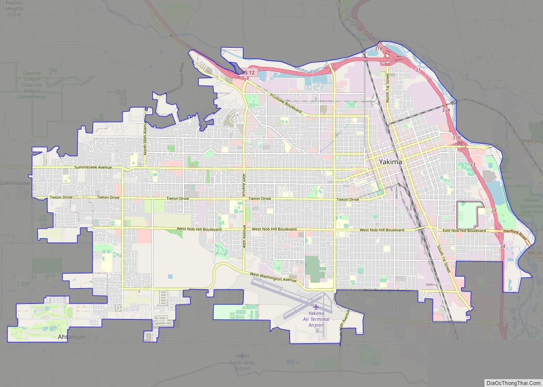
Map of Olympia city

Map of Olympia city

Olympia is the capital of the U.S. state of Washington and the county seat and largest city of Thurston County. It is 60 miles (100 km) southwest of the state’s most populous city, Seattle, and is a cultural center of the southern Puget Sound region. The Squaxin and other Coast Salish peoples inhabited the southern Puget … Read more

Map of Acme CDP

Map of Acme CDP

Acme is a rural village in Whatcom County, Washington, United States. There is a general store, post office, gas station, diner, elementary school and two churches located there. Acme is also included in, and the source-name for, a larger census-designated place (CDP). The Census Bureau no longer tracks the population for the village itself, but … Read more

Map of Aberdeen city, Washington

Map of Aberdeen city, Washington

Aberdeen (/ˈæbərdiːn/) is a city in Grays Harbor County, Washington, United States. The population was 17,013 at the 2020 census. The city is the economic center of Grays Harbor County, bordering the cities of Hoquiam and Cosmopolis. Aberdeen is occasionally referred to as the “Gateway to the Olympic Peninsula”. Aberdeen city overview: Name: Aberdeen city … Read more

Map of Aberdeen Gardens CDP

Map of Aberdeen Gardens CDP

Aberdeen Gardens is a census-designated place (CDP) in Grays Harbor County, Washington, United States. The population was 279 at the 2010 census. Aberdeen Gardens CDP overview: Name: Aberdeen Gardens CDP LSAD Code: 57 LSAD Description: CDP (suffix) State: Washington County: Grays Harbor County Elevation: 46 ft (14 m) Total Area: 1.62 sq mi (4.19 km²) Land Area: 1.62 sq mi (4.19 km²) Water … Read more

Map of Alger CDP, Washington

Map of Alger CDP, Washington

Alger is a census-designated place (CDP) in Skagit County, Washington, United States. The population was 403 at the 2010 census. It is included in the Mount Vernon–Anacortes, Washington Metropolitan Statistical Area. Alger is located along Old Highway 99 North Road. It is near the midway point of the route between Seattle and Vancouver, 76 miles … Read more

Map of Alderwood Manor CDP

Map of Alderwood Manor CDP

Alderwood Manor is a census-designated place (CDP) in Snohomish County, Washington, United States. The population was 10,198 at the 2020 census. Prior to the 2000 census, Alderwood Manor was counted as part of the Alderwood Manor-Bothell North CDP. Alderwood Manor CDP overview: Name: Alderwood Manor CDP LSAD Code: 57 LSAD Description: CDP (suffix) State: Washington … Read more

Map of Alderton CDP

Map of Alderton CDP

Alderton is a census-designated place (CDP) in Pierce County, Washington, United States. The population was 2,893 at the 2010 census. The community is located in the Puyallup River Valley between the cities of Sumner and Orting. Alderton CDP overview: Name: Alderton CDP LSAD Code: 57 LSAD Description: CDP (suffix) State: Washington County: Pierce County Total … Read more

Map of Alder CDP, Washington

Map of Alder CDP, Washington

Alder is a census-designated place (CDP) in Pierce County, Washington, United States. The population was 227 at the 2010 census. The community is located along the shore of Alder Lake on State Route Highway 7 near the entrance to Mount Rainier National Park. A post office called Alder was established in 1902, and remained in … Read more

Map of Albion town, Washington

Map of Albion town, Washington

Albion town overview: Name: Albion town LSAD Code: 43 LSAD Description: town (suffix) State: Washington County: Whitman County FIPS code: 5301010 Online Interactive Map Albion online map. Source: Basemap layers from Google Map, Open Street Map (OSM), Arcgisonline, Wmflabs. Boundary Data from Database of Global Administrative Areas. Albion location map. Where is Albion town? Albion … Read more

Map of Airway Heights city

Map of Airway Heights city

Airway Heights is a city in Spokane County, Washington, United States, just west of Spokane. The population was 10,757 at the 2020 census. The city’s name was taken from its close proximity to the runways at Fairchild Air Force Base and Spokane International Airport. Airway Heights city overview: Name: Airway Heights city LSAD Code: 25 … Read more

Map of Ahtanum CDP

Map of Ahtanum CDP

Ahtanum (/əˈtɛnəm/) is a census-designated place (CDP) in Yakima County, Washington. The population was 3,601 at the time of the 2010 census. Ahtanum CDP overview: Name: Ahtanum CDP LSAD Code: 57 LSAD Description: CDP (suffix) State: Washington County: Yakima County Elevation: 1,247 ft (380 m) Total Area: 9.7 sq mi (25.1 km²) Land Area: 9.7 sq mi (25.1 km²) Water Area: 0.0 sq mi (0.0 km²) … Read more

Map of Addy CDP

Map of Addy CDP

Addy is an unincorporated community and census-designated place in Stevens County, Washington, United States. It is located on the Colville River (Washington) and U.S. Route 395 between Colville to the north and Chewelah to the south. Addy CDP overview: Name: Addy CDP LSAD Code: 57 LSAD Description: CDP (suffix) State: Washington County: Stevens County Elevation: … Read more