Map of Bac Lieu province

Map of Bac Lieu province

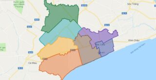
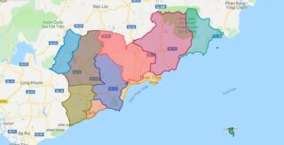
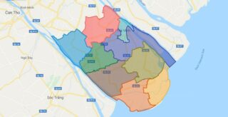
Bac Lieu Province is a province of Vietnam. It is a coastal province, and is situated in the Mekong Delta region of the southern part of the country. Political Map of Bac Lieu province Interactive online map of Bac Lieu Click on to view map in “full screen” mode. Source: Database of Global Administrative Areas, … Read more

Map of Lang Son province

Map of Lang Son province

Lang Son is a province in far northern Vietnam, bordering Guangxi province in China. Its capital is also called Lang Son, which is a strategically important town at the border with China and is 137 km northeast of Hanoi connected by rail and road. Lang Son Province is bounded by China in the north, Cao … Read more

District Map of Ho Chi Minh City

District Map of Ho Chi Minh City

Political Map of Ho Chi Minh city Interactive online map of Ho Chi Minh Click on to view map in “full screen” mode. Source: Database of Global Administrative Areas, Global Map of Vietnam ©ISCGM, Ministry of Nutural Resources and Environment -Vietnam.Base Map Layer: Open Street Map (OSM), Arcgisonline, Google Map, Wmflabs. Large scale maps of … Read more

Map of Gia Lai province

Map of Gia Lai province

Gia Lai is a province in the Central Highlands of Vietnam. Political Map of Gia Lai province Interactive online map of Gia Lai Click on to view map in “full screen” mode. Source: Database of Global Administrative Areas, Global Map of Vietnam ©ISCGM, Ministry of Nutural Resources and Environment -Vietnam.Base Map Layer: Open Street Map … Read more

Map of Dong Nai province

Map of Dong Nai province

Dong Nai is a province in the Southeast region of Vietnam, located east and northeast of Ho Chi Minh City (Saigon). The largest city in Dong Nai is Bien Hoa. Prior to Vietnamese colonization, the area was dominated by the Funan, Chenla, Khmer empire and subsequent influences until 1627. The area was known as Kampeap … Read more

Map of Binh Thuan province

Map of Binh Thuan province

Binh Thuan is a province of Vietnam. It is located on the country’s South Central Coast, not far from Ho Chi Minh City. It is sometimes seen as part of the Southeast region. The province is known for its scenery and beaches. There are also a number of sites of archaeological significance. Political Map of … Read more

Map of Yen Bai province

Map of Yen Bai province

Yen Bai is an agricultural-based province located in Tay Bac, the northern part of northern-central Vietnam. It shares borders with six provinces which are Ha Giang Province, Lao Cai Province, Lai Chau Province, Son La Province, Phu Tho Province, and Tuyen Quang Province. The province covers an area of 6899.5 square kilometres and as of … Read more

Map of Khanh Hoa province

Map of Khanh Hoa province

Khanh Hoa is a province of Vietnam located in the South Central Coast. It has a population of 1,066,300 and spans an area of 5,197 km². Its capital is Nha Trang. Khanh Hoa is the site of Bao Dai’s summer home, the Pasteur Institute of Nha Trang, the Institute of Oceanography, the Institute of Vaccines … Read more

Map of Quang Ngai province

Map of Quang Ngai province

Quang Ngai is a province in the South Central Coast region of Vietnam, on the coast of South China Sea. It is located south of Hanoi and north of Ho Chi Minh City. Political Map of Quang Ngai province Interactive online map of Quang Ngai Click on to view map in “full screen” mode. Source: … Read more

Map of Hung Yen province

Map of Hung Yen province

Hung Yen is a province in the Red River Delta of northern Vietnam. Political Map of Hung Yen province Interactive online map of Hung Yen Click on to view map in “full screen” mode. Source: Database of Global Administrative Areas, Global Map of Vietnam ©ISCGM, Ministry of Nutural Resources and Environment -Vietnam.Base Map Layer: Open … Read more

Map of Long An province

Map of Long An province

Long An is a province in the Mekong Delta region of southern Vietnam. The provincial capital is Tan An, other major cities include Ben Luc, Duc Hoa, Thanh Hoa, and Moc Hoa District. There are 13 districts within the province. Political Map of Long An province Interactive online map of Long An Click on to … Read more

Map of Tra Vinh province

Map of Tra Vinh province

Tra Vinh is a province in the Mekong Delta region of Vietnam. The capital is Tra Vinh Town. Political Map of Tra Vinh province Interactive online map of Tra Vinh Click on to view map in “full screen” mode. Source: Database of Global Administrative Areas, Global Map of Vietnam ©ISCGM, Ministry of Nutural Resources and … Read more