Map of West Haven city

Map of West Haven city, Connecticut

West Haven is a city in New Haven County, Connecticut, United States, located on the coast of Long Island Sound. The city is part of the South Central Connecticut Planning Region. At the 2020 census, the population of the city was 55,584. West Haven city overview: Name: West Haven city LSAD Code: 25 LSAD Description: … Read more

Map of Westbrook Center CDP

Map of Westbrook Center CDP

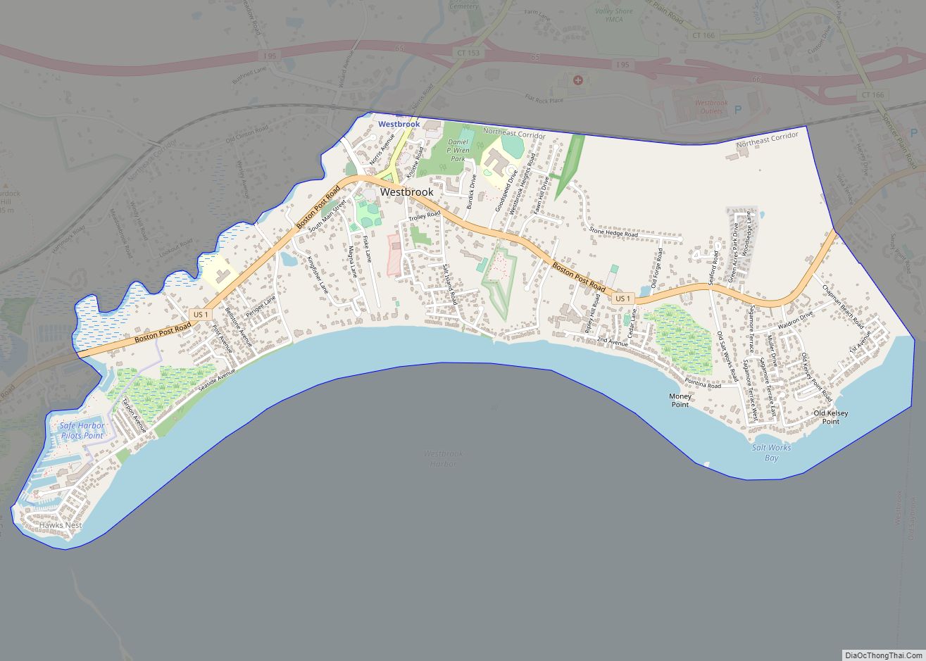
Westbrook Center is a census-designated place (CDP) comprising the primary village and adjacent residential land in the town of Westbrook, Middlesex County, Connecticut, United States. It is in the southern part of the town, along U.S. Route 1 and bordered to the south by Long Island Sound. To the east it is bordered by the … Read more

Map of West Simsbury CDP

Map of West Simsbury CDP

West Simsbury is a census-designated place (CDP) and section of the town of Simsbury in Hartford County, Connecticut, United States. The population of the CDP was 2,447 at the 2010 census. West Simsbury CDP overview: Name: West Simsbury CDP LSAD Code: 57 LSAD Description: CDP (suffix) State: Connecticut County: Hartford County Elevation: 323 ft (98 m) Total … Read more

Map of Willimantic CDP

Map of Willimantic CDP

Willimantic is a census-designated place located in the town of Windham in Windham County, Connecticut, United States. It is a former city and borough, and is currently organized as one of two tax districts within the Town of Windham. Willimantic is part of the Southeastern Connecticut Planning Region. Known as “Thread City” for the American … Read more

Map of Wethersfield CDP

Map of Wethersfield CDP

Wethersfield is a town located in Hartford County, Connecticut, United States. It is located immediately south of Hartford along the Connecticut River. The town is part of the Capitol Planning Region. The population was 27,298 at the time of the 2020 census. Many records from colonial times spell the name “Weathersfield” and “Wythersfield,” while Native … Read more

Map of Westport CDP

Map of Westport CDP, Connecticut

Westport Village is a census-designated place (CDP) in the town of Westport, Fairfield County, Connecticut, United States. It comprises the town center of Westport. Westport Village was first listed as a CDP prior to the 2020 census. Westport CDP overview: Name: Westport CDP LSAD Code: 57 LSAD Description: CDP (suffix) State: Connecticut County: Fairfield County … Read more

Map of Winsted CDP

Map of Winsted CDP, Connecticut

Winsted is a census-designated place and an incorporated city in Litchfield County, Connecticut, United States. It is part of the town of Winchester. The population of Winsted was 7,712 at the 2010 census, out of 11,242 in the entire town of Winchester. Winsted is part of the Northwest Hills Planning Region. Winsted CDP overview: Name: … Read more

Map of Windsor Locks CDP

Map of Windsor Locks CDP

Windsor Locks is a town in Hartford County, Connecticut, United States. The town is part of the Capitol Planning Region. As of the 2020 census, its population was 12,613. It is the site of Bradley International Airport, which serves the Greater Hartford-Springfield region and occupies approximately 1/3 of the town. Windsor Locks is also the … Read more

Map of Wilton Center CDP

Map of Wilton Center CDP

Wilton Center is a neighborhood/section and census-designated place (CDP) in the town of Wilton in Fairfield County, Connecticut, United States. As of the 2010 census it had a population of 732. The CDP partially overlaps the Wilton Center Historic District. Wilton Center CDP overview: Name: Wilton Center CDP LSAD Code: 57 LSAD Description: CDP (suffix) … Read more

Map of Woodmont borough

Map of Woodmont borough

Woodmont borough overview: Name: Woodmont borough LSAD Code: 21 LSAD Description: borough (suffix) State: Connecticut County: New Haven County FIPS code: 0988050 Online Interactive Map Woodmont online map. Source: Basemap layers from Google Map, Open Street Map (OSM), Arcgisonline, Wmflabs. Boundary Data from Database of Global Administrative Areas. Woodmont location map. Where is Woodmont borough? … Read more

Map of Woodbury Center CDP

Map of Woodbury Center CDP

Woodbury Center is a census-designated place (CDP) in Litchfield County, Connecticut, United States. It comprises the twin villages of Woodbury and North Woodbury and surrounding residential land in the town of Woodbury. As of the 2010 census, the population of the CDP was 1,294, out of 9,975 in the entire town. Woodbury Center CDP overview: … Read more