Map of Welcome CDP, South Carolina

Map of Welcome CDP, South Carolina

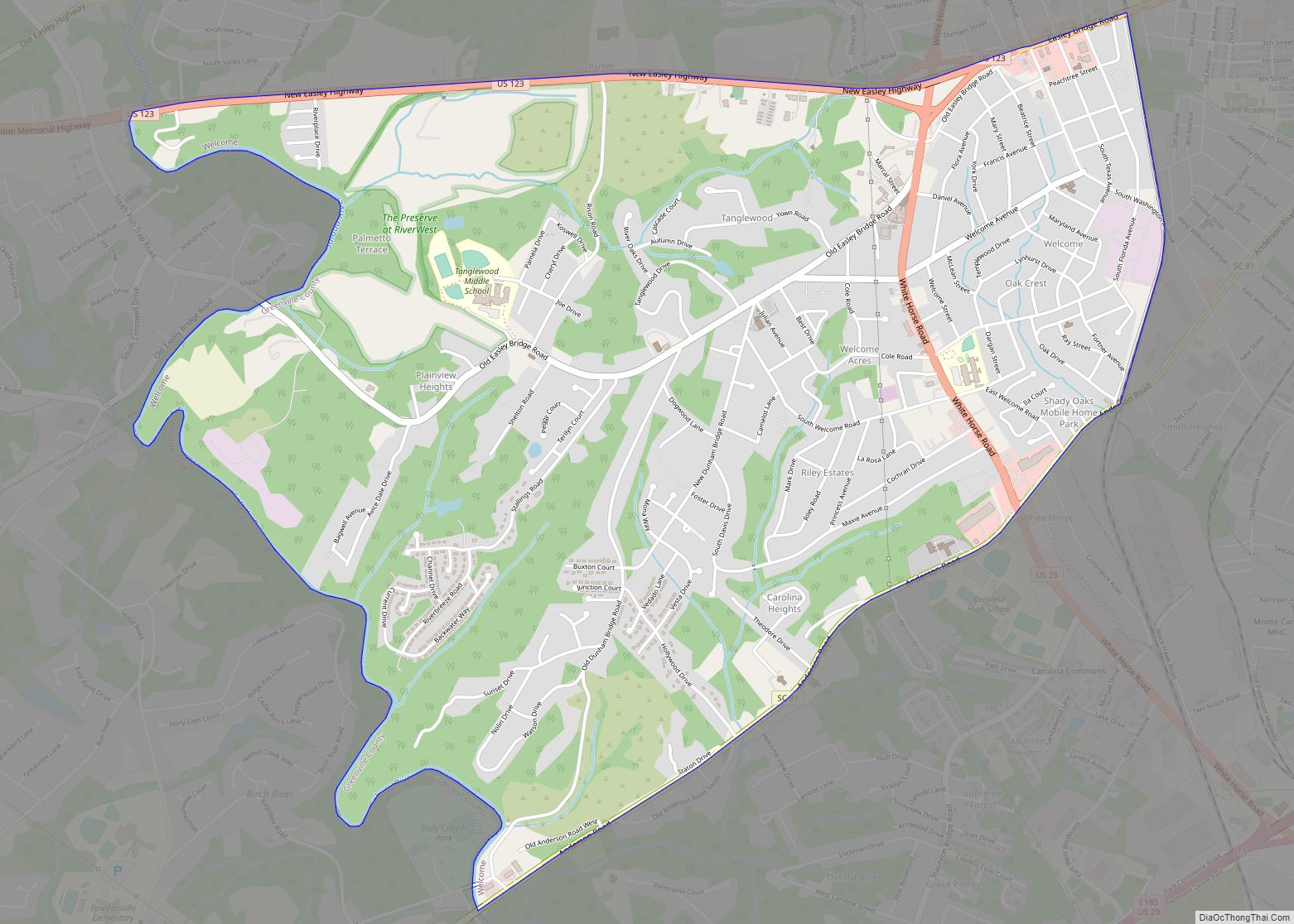
Welcome is a census-designated place (CDP) in Greenville County, South Carolina, United States. The population was 6,668 at the 2010 census. It is part of the Greenville–Mauldin–Easley Metropolitan Statistical Area. Welcome has been noted for its colorful place name. Welcome CDP overview: Name: Welcome CDP LSAD Code: 57 LSAD Description: CDP (suffix) State: South Carolina … Read more

Map of Windsor town, South Carolina

Map of Windsor town, South Carolina

Windsor is a town in Aiken County, South Carolina, United States. The population was 121 at the 2010 census. It is part of the Augusta, Georgia metropolitan area. Windsor town overview: Name: Windsor town LSAD Code: 43 LSAD Description: town (suffix) State: South Carolina County: Aiken County Elevation: 387 ft (118 m) Total Area: 0.87 sq mi (2.26 km²) Land … Read more

Map of Williston town, South Carolina

Map of Williston town, South Carolina

Williston is a town in Barnwell County, South Carolina, United States. The population was 3,139 at the 2010 census. The town lies in the center of the Charleston-Hamburg railroad line, the line of the Best Friend locomotive. The train tracks were removed in the 1990s, but the track site has been designated as historically significant … Read more

Map of Willington CDP

Map of Willington CDP

Willington is a census-designated place (CDP) in McCormick County, South Carolina, United States. The population was 177 at the 2000 census. Willington CDP overview: Name: Willington CDP LSAD Code: 57 LSAD Description: CDP (suffix) State: South Carolina County: McCormick County Elevation: 486 ft (148 m) Total Area: 6.00 sq mi (15.53 km²) Land Area: 5.96 sq mi (15.42 km²) Water Area: 0.04 sq mi (0.11 km²) … Read more

Map of York city, South Carolina

Map of York city, South Carolina

York /ˈjɔːrk/ is a city in and county seat of York County, South Carolina, United States. The population was approximately 6,985 at the 2000 census and up to 7,736 at the 2010 census. York is located approximately 27 miles (43 km) southwest of Charlotte, North Carolina and 13 miles (21 km) west of Rock Hill, South Carolina. … Read more

Map of Yemassee town

Map of Yemassee town

Yemassee (/ˈjɛməsiː/) is a small Lowcountry town in Beaufort and Hampton counties in the U.S. state of South Carolina. The population was 1,027 at the 2010 census. Yemassee is near the borders of Colleton and Jasper counties. The town is divided by the county line between Beaufort and Hampton counties, which follows the roadbed of … Read more

Map of Woodruff city, South Carolina

Map of Woodruff city, South Carolina

Woodruff is a city in Spartanburg County, South Carolina, United States, located in upstate South Carolina. The population was 4,333 at the 2020 census. Woodruff city overview: Name: Woodruff city LSAD Code: 25 LSAD Description: city (suffix) State: South Carolina County: Spartanburg County Elevation: 787 ft (240 m) Total Area: 5.09 sq mi (13.19 km²) Land Area: 5.07 sq mi (13.14 km²) Water … Read more

Map of Woodford town

Map of Woodford town, South Carolina

Woodford is a town in Orangeburg County, South Carolina, United States. The population was 185 at the 2010 census. Woodford town overview: Name: Woodford town LSAD Code: 43 LSAD Description: town (suffix) State: South Carolina County: Orangeburg County Elevation: 381 ft (116 m) Total Area: 0.79 sq mi (2.03 km²) Land Area: 0.79 sq mi (2.03 km²) Water Area: 0.00 sq mi (0.00 km²) Total Population: … Read more

Map of Woodfield CDP

Map of Woodfield CDP

Woodfield is a census-designated place (CDP) in Richland County, South Carolina, United States. The population was 9,303 at the 2010 census. It is part of the Columbia, South Carolina Metropolitan Statistical Area. Woodfield CDP overview: Name: Woodfield CDP LSAD Code: 57 LSAD Description: CDP (suffix) State: South Carolina County: Richland County Elevation: 341 ft (104 m) Total … Read more

Map of Winnsboro town, South Carolina

Map of Winnsboro town, South Carolina

Winnsboro is a town in Fairfield County, South Carolina, United States. The population was 3,550 at the 2010 census. The population was 3,215 at the 2020 census. A population decrease of approximately 9.5% for the same 10 year period. It is the county seat of Fairfield County. Winnsboro is part of the Columbia, South Carolina … Read more

Map of Winnsboro Mills CDP

Map of Winnsboro Mills CDP

Winnsboro Mills is an unincorporated community and census-designated place (CDP) in Fairfield County, South Carolina, United States. The population was 1,898 at the 2010 census, down from 2,263 at the 2000 census. It is part of the Columbia, South Carolina Metropolitan Statistical Area. Winnsboro Mills CDP overview: Name: Winnsboro Mills CDP LSAD Code: 57 LSAD … Read more