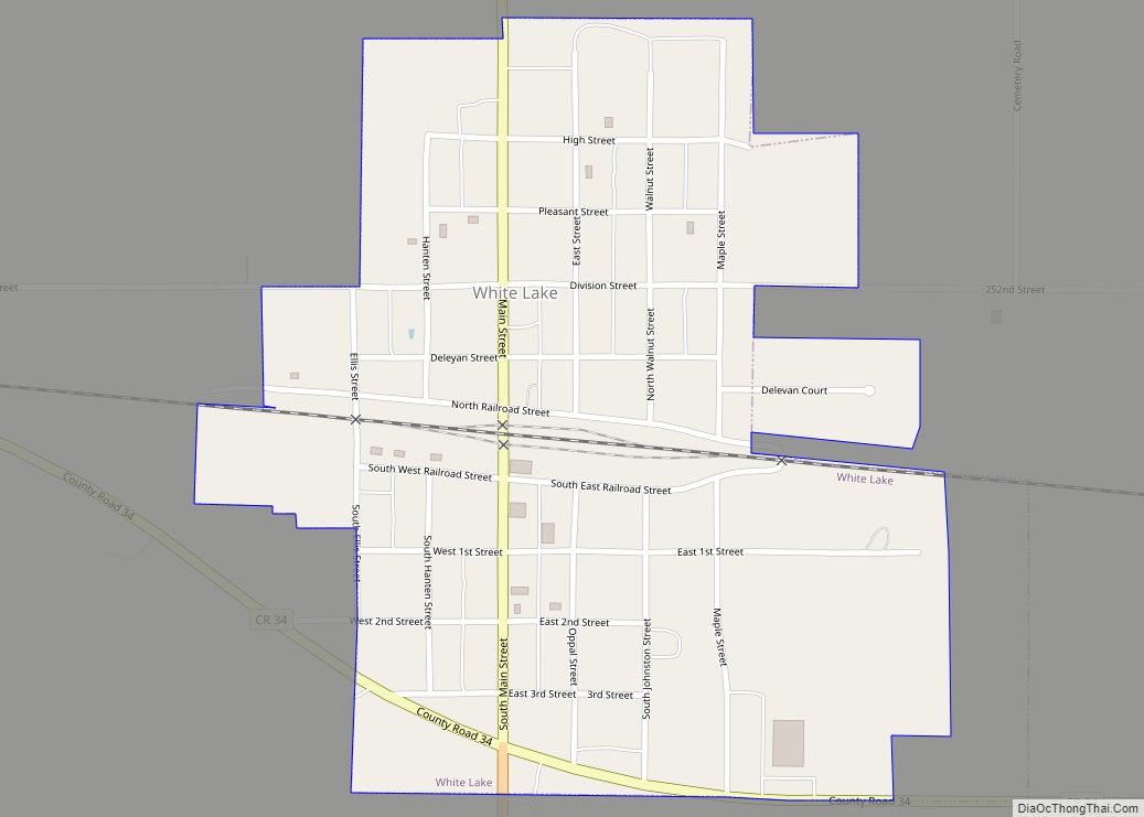
Map of White city, South Dakota

Map of White city, South Dakota

White is a city in Brookings County, South Dakota, United States. The population was 537 at the 2020 census. White city overview: Name: White city LSAD Code: 25 LSAD Description: city (suffix) State: South Dakota County: Brookings County Incorporated: 1887 Elevation: 1,785 ft (544 m) Total Area: 0.87 sq mi (2.26 km²) Land Area: 0.87 sq mi (2.26 km²) Water Area: 0.00 sq mi (0.00 km²) … Read more

Map of Yankton city

Map of Yankton city

Yankton is a city in and the county seat of Yankton County, South Dakota, United States. The population was 15,411 at the 2020 census, and it is the principal city of the Yankton Micropolitan Statistical Area, which includes the entirety of Yankton County and which had an estimated population of 23,297 as of July 1, … Read more

Map of Yale town, South Dakota

Map of Yale town, South Dakota

Yale is an incorporated town in Beadle County, South Dakota, United States. The population was 112 at the 2020 census. Yale town overview: Name: Yale town LSAD Code: 43 LSAD Description: town (suffix) State: South Dakota County: Beadle County Incorporated: 1925 Elevation: 1,342 ft (409 m) Total Area: 0.15 sq mi (0.39 km²) Land Area: 0.14 sq mi (0.38 km²) Water Area: 0.00 sq mi … Read more

Map of Wounded Knee CDP

Map of Wounded Knee CDP

Wounded Knee (Lakota: Čaŋkpé Opí) is a census-designated place (CDP) on the Pine Ridge Indian Reservation in Oglala Lakota County, South Dakota, United States. The population was 364 at the 2020 census. The town is named for the Wounded Knee Creek which runs through the region. The bones and heart of the Sioux chief Crazy … Read more

Map of Worthing city

Map of Worthing city

Worthing is a city in Lincoln County, South Dakota, United States and is a suburb of Sioux Falls. The population was 927 at the 2020 census. Worthing city overview: Name: Worthing city LSAD Code: 25 LSAD Description: city (suffix) State: South Dakota County: Lincoln County Founded: 1879 Elevation: 1,362 ft (415 m) Total Area: 0.56 sq mi (1.45 km²) Land … Read more

Map of Woonsocket city, South Dakota

Map of Woonsocket city, South Dakota

Woonsocket is a city in Sanborn County, South Dakota. The population was 631 at the 2020 census. It is the county seat of Sanborn County. Woonsocket city overview: Name: Woonsocket city LSAD Code: 25 LSAD Description: city (suffix) State: South Dakota County: Sanborn County Incorporated: 1888 Elevation: 1,306 ft (398 m) Total Area: 0.80 sq mi (2.06 km²) Land Area: … Read more

Map of Wood town

Map of Wood town

Wood is a town in Mellette County, South Dakota, United States. The population was 41 at the 2020 census. Wood town overview: Name: Wood town LSAD Code: 43 LSAD Description: town (suffix) State: South Dakota County: Mellette County Incorporated: 1929 Elevation: 2,152 ft (656 m) Total Area: 0.25 sq mi (0.64 km²) Land Area: 0.25 sq mi (0.64 km²) Water Area: 0.00 sq mi (0.00 km²) … Read more

Map of Wolsey town

Map of Wolsey town

Wolsey is a town in Beadle County, South Dakota, United States. The population was 459 at the 2020 census. Wolsey town overview: Name: Wolsey town LSAD Code: 43 LSAD Description: town (suffix) State: South Dakota County: Beadle County Incorporated: 1883 Elevation: 1,352 ft (412 m) Total Area: 2.30 sq mi (5.96 km²) Land Area: 2.27 sq mi (5.87 km²) Water Area: 0.04 sq mi (0.09 km²) … Read more

Map of Winner city

Map of Winner city

Winner is a city in central Tripp County, South Dakota, United States. The population was 2,921 at the 2020 census. It is the county seat of Tripp County. Winner also serves as the administrative center of neighboring Todd County, which does not have its own county seat. The nearest airport is Winner Regional Airport. Winner … Read more