Map of Territory of Norfolk Island

Map of Territory of Norfolk Island

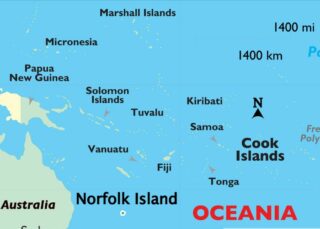
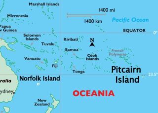
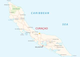
Covering a total land area of only 34.6 sq.km, Norfolk Island is an external territory under Australia located in the South Pacific Ocean. The Norfolk Island is mainly a mountain top remnant of an elongated shield volcano; defined by pine trees and jagged cliffs. Major portion of Norfolk Island is a plateau formed from horizontal … Read more

Map of Niue

Map of Niue

Covering a land area of 261 sq.km (100.95 sq mi), Niue is an island country and a raised coral atoll located in the southwestern Pacific Ocean. Niue is one of the world’s largest coral islands. It consists of steep limestone cliffs lying along the coast, giving way to a central plateau. Two large bays indent the western … Read more

Map of Tokelau

Map of Tokelau

Covering a combined land area of only 10.8 sq.km (3.9 sq mi), Tokelau is a dependent territory of New Zealand and comprises of 3 small coral atolls (Atafu, Nukunonu and Fakaofo) located in the South Pacific Ocean. Each of the low-lying coral atolls encloses a large central lagoon and are surrounded by a number of reef-bound islets … Read more

Map of Vatican

Map of Vatican

Vatican City is the world’s smallest country. It covers an area of only 0.19 sq mi or 0.49 sq. km. It sits on a low hill known as the Vatican Hill. The highest point here is at 250 ft (76 m) and the lowest point is at 63 ft (19 m). The country lacks any … Read more

Map of Pitcairn

Map of Pitcairn, Henderson, Ducie, and Oeno Islands

Covering a combined land area of only 47 sq.km, Pitcairn Islands 18 sq mi) is a group of 4 volcanic islands and the only British Overseas Territory located in the Southern Pacific Ocean. The main island is a rugged volcanic formation and is girded by rocky coastal cliffs. Pitcairn is a volcanic island while Ducie and Oeno … Read more

Map of French Guiana

Map of French Guiana

Covering an area of 83,534 sq. km, French Guiana located in the northeastern edge of South America, is France’s 2nd largest region. A narrow coastal strip fronts the Atlantic Ocean coastline of French Guiana. To the south, the land is an unsettled wilderness, covered by a dense jungle and parts of the Amazon Rain Forest, … Read more

Map of Abkhazia

Map of Abkhazia

Abkhazia (/æbˈkɑːziə/ (listen)), officially the Republic of Abkhazia, is a partially recognised state in the South Caucasus, at the intersection of Eastern Europe and Western Asia. It lies on the eastern coast of the Black Sea in northwestern Georgia. It is recognised by most countries as part of the latter. It covers 8,665 square kilometres … Read more

Map of Caribbean Netherlands

Map of Caribbean Netherlands

The Caribbean Netherlands (Dutch: Caribisch Nederland, pronounced [kaˈribisˌnedərˌlɑnt] (listen)) are the three public bodies of the Netherlands that are located in the Caribbean Sea. They consist of the islands of Bonaire, Sint Eustatius and Saba, although the term “Caribbean Netherlands” is sometimes used to refer to all of the islands in the Dutch Caribbean. In … Read more

Map of Curacao

Map of Curacao

Curaçao (/ˈk(j)ʊərəˌsoʊ, -ˌsaʊ, ˌk(j)ʊərəˈsoʊ, -ˈsaʊ/ KURE-ə-soh, -⁠sow, -⁠SOH, -⁠SOW; Dutch: [kyːraːˈsʌu, kuːr-] (listen); Papiamento: Kòrsou, [ˈkɔrsɔu̯]), officially the Country of Curaçao (Dutch: Land Curaçao; Papiamento: Pais Kòrsou), is a Lesser Antilles island country in the southern Caribbean Sea and the Dutch Caribbean region, about 65 km (40 mi) north of the Venezuela coast. It is a constituent country … Read more

Map of Faroe Islands

Map of Faroe Islands

The Faroe Islands (/ˈfɛəroʊ/ FAIR-oh), or simply the Faroes (Faroese: Føroyar [ˈfœɹjaɹ] (listen); Danish: Færøerne [ˈfeɐ̯ˌøˀɐnə]), are a North Atlantic island group and an autonomous territory of the Kingdom of Denmark. They are located 320 kilometres (200 mi) north-northwest of the United Kingdom, and about halfway between Norway (580 kilometres (360 mi) away) and Iceland (430 kilometres … Read more

Map of Guadeloupe

Map of Guadeloupe

The Guadeloupe Archipelago includes the large butterfly-shaped principal islands of Basse-Terre and Grande-Terre and numerous smaller islands. The two principal islands are separated by the narrow Salée River. As observed on the map, the Basse-Terre island is slightly mountainous and lush, with densely forested areas. It’s dominated by a single (still-active) volcano – La Grande … Read more

Map of Guernsey

Map of Guernsey

Guernsey (/ˈɡɜːrnzi/ (listen); Guernésiais: Guernési; French: Guernesey) is an island in the English Channel off the coast of Normandy that is part of the Bailiwick of Guernsey, a British Crown Dependency. It is the second largest of the Channel Islands, an island group roughly north of Saint-Malo and west of the Cotentin Peninsula. The jurisdiction … Read more