Covering a combined land area of only 47 sq.km, Pitcairn Islands 18 sq mi) is a group of 4 volcanic islands and the only British Overseas Territory located in the Southern Pacific Ocean. The main island is a rugged volcanic formation and is girded by rocky coastal cliffs. Pitcairn is a volcanic island while Ducie and Oeno are coastal atolls. Henderson Island is the largest island and accounts for 67% of the total land area of the island territory. It is an uplifted coral island and is entirely untouched by humans. The highest point on the Pitcairn Islands is the Pawala Valley Ridge with an elevation of 1,138ft (347m). The lowest point is the Pacific Ocean (0m).
| Legal Name: | Pitcairn, Henderson, Ducie, and Oeno Islands |
|---|---|
| Capital Value: | Adamstown |
| Official languages: |
|
| Demonym(s): |
|
| Government: | Devolved locally governing dependency |
| Legislature: | Island Council |
| Total Area: | 47 km² |
| Land Area: | 47 km² |
| Population: | 54 |
| Density: | 1/km (2.6/sq mi) (not ranked) |
| Currency Value: | New Zealand dollars (NZD) |
| Driving side: | left |
| Calling code: | +64 |
| Internet TLD: | .pn |
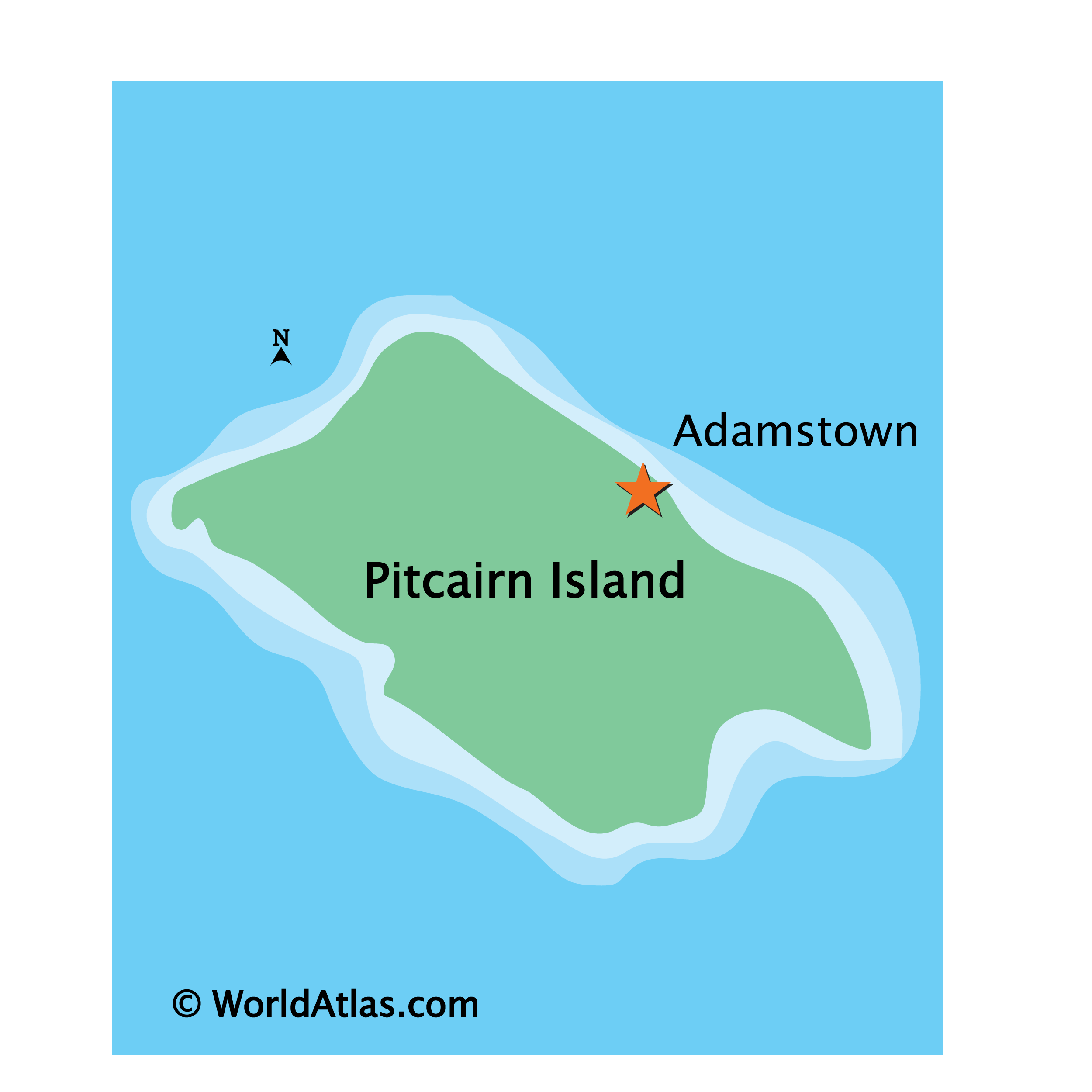
Pitcairn Island is a remote, isolated island located in the South Pacific Ocean. It is the only inhabited island of the Pitcairn Islands group, which also includes the uninhabited islands of Henderson, Ducie, and Oeno. The only major settlement on Pitcairn Island is Adamstown, the capital of the Pitcairn Islands. The island is renowned for its natural beauty, with its rugged coastline and lush interior featuring a variety of flora and fauna.
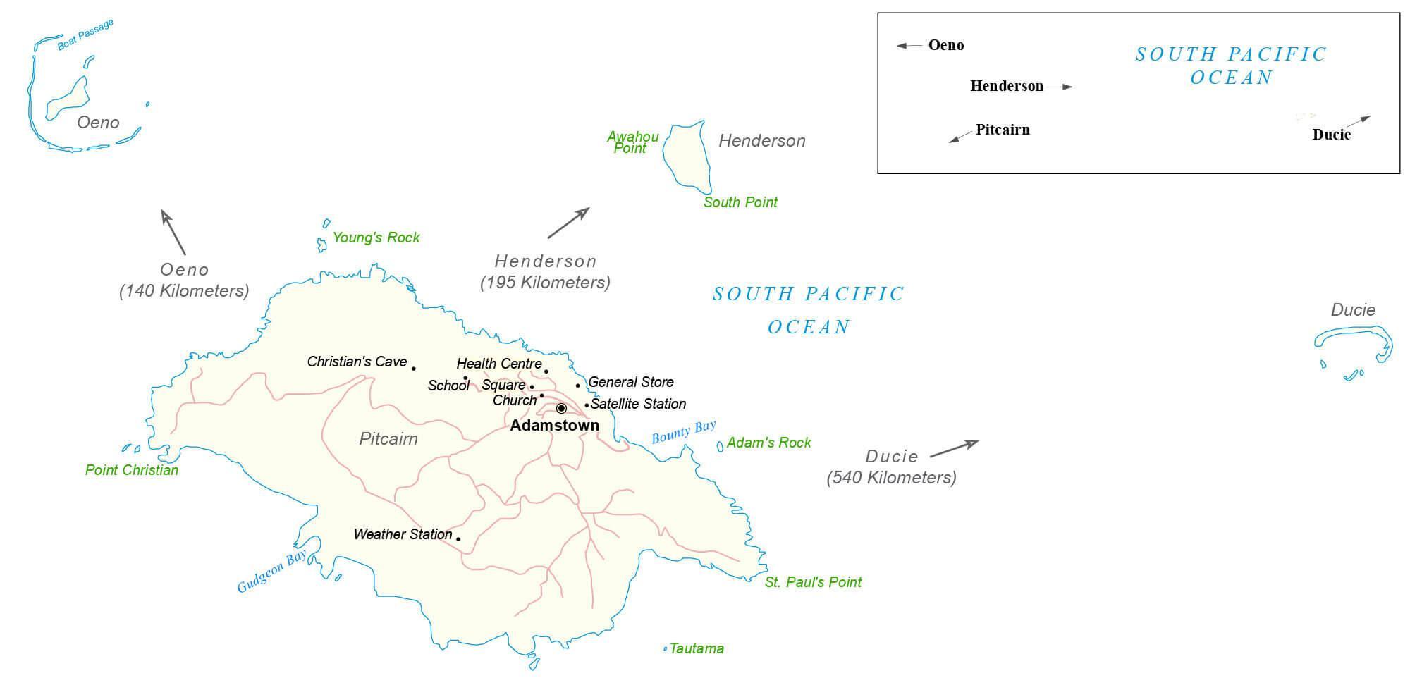
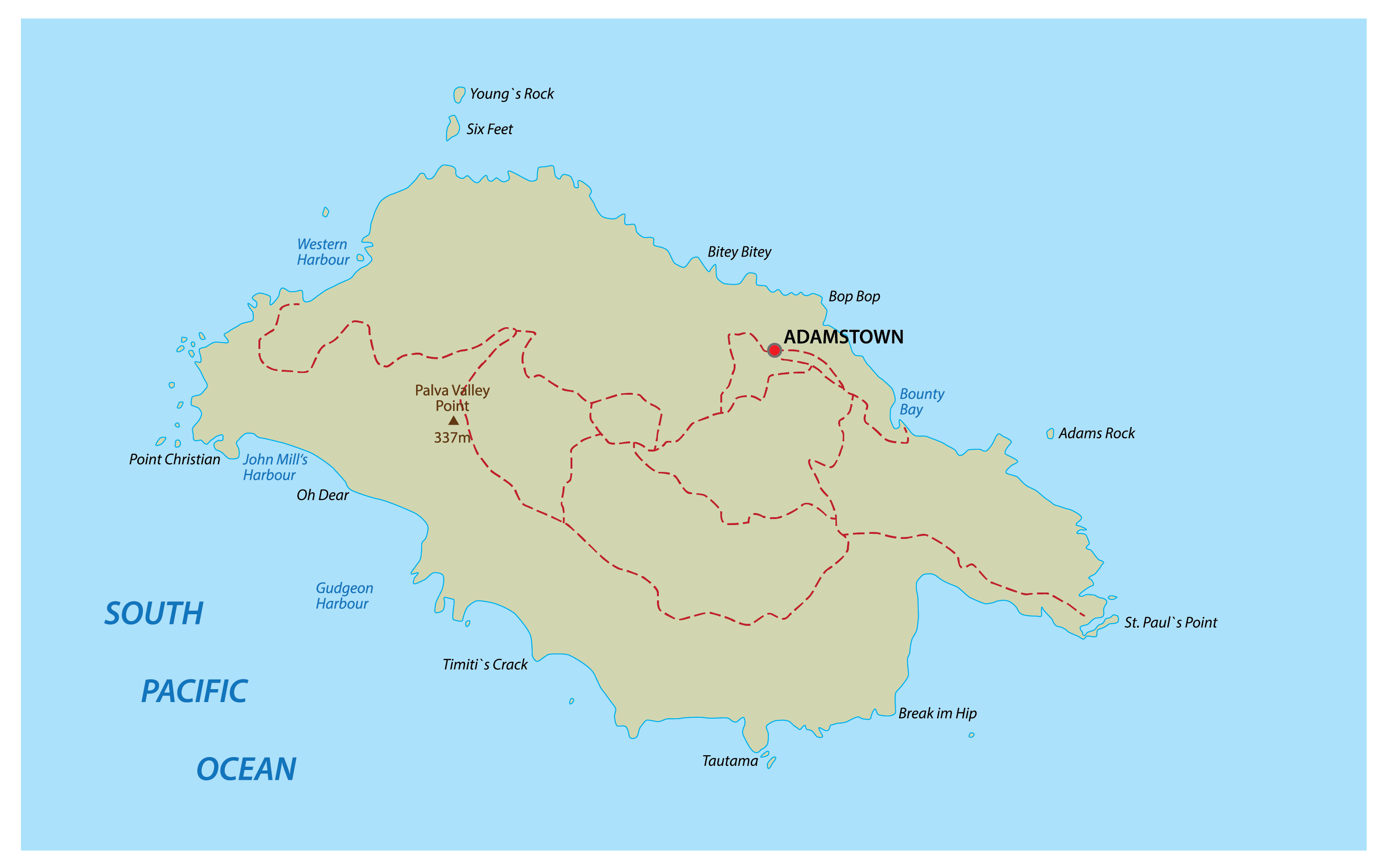
This map of Pitcairn Island displays the four major islands and the only major settlement on the island, Adamstown. It also shows the significant features of each island, including Pitcairn, Henderson, Ducie, and Oeno. Situated in the South Pacific Ocean, Pitcairn Island is a remote and isolated island, featuring a rugged coastline and lush interior. It is the only inhabited island of the Pitcairn Islands group, and the only major settlement on the island is Adamstown, the capital of the Pitcairn Islands.
Explore the remote and isolated Pitcairn Island with this detailed map. Discover the four major islands – Pitcairn, Henderson, Ducie, and Oeno – as well as the only major settlement on the island, Adamstown. Take in the natural beauty of the island, from its rugged coastline to its lush interior.
Location Maps
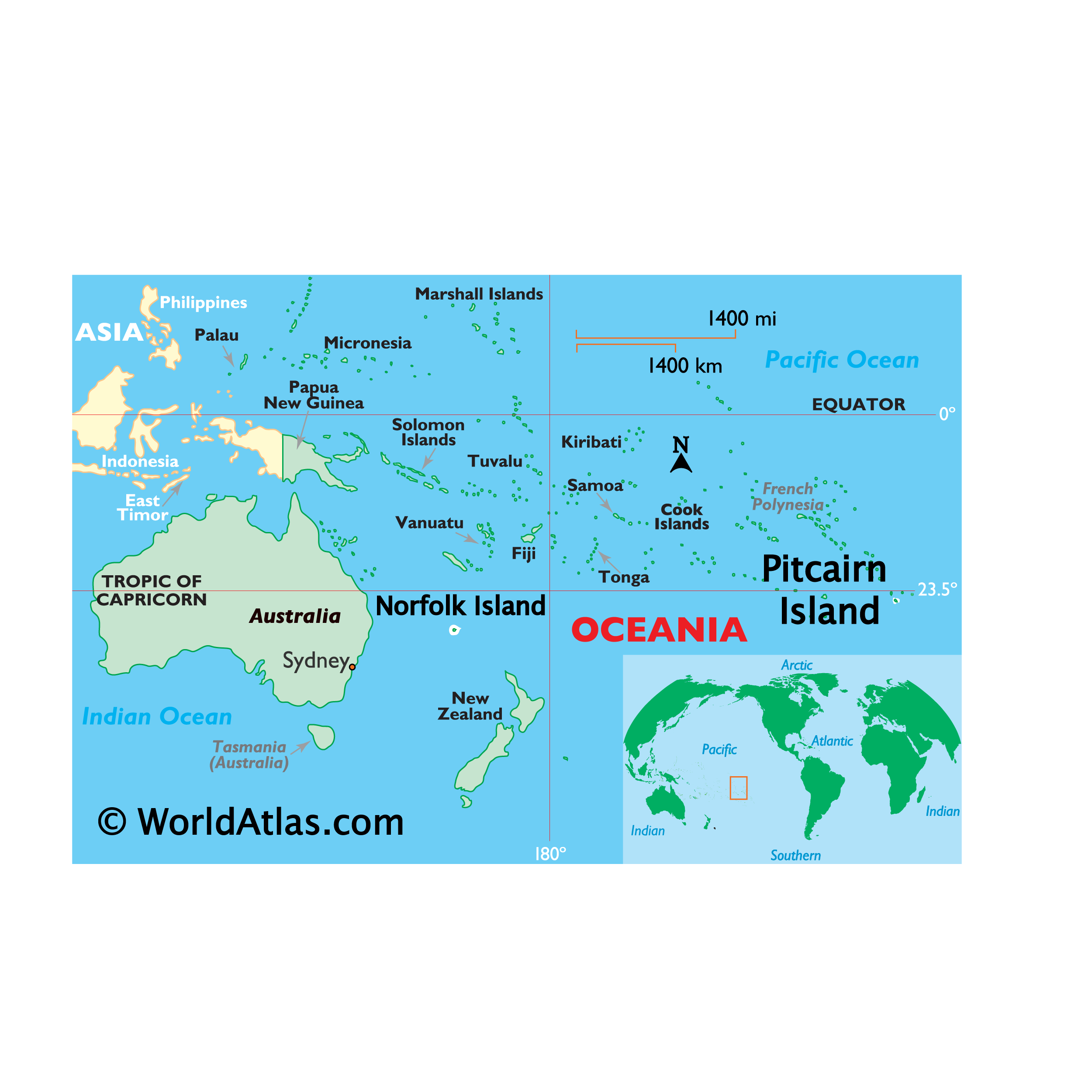
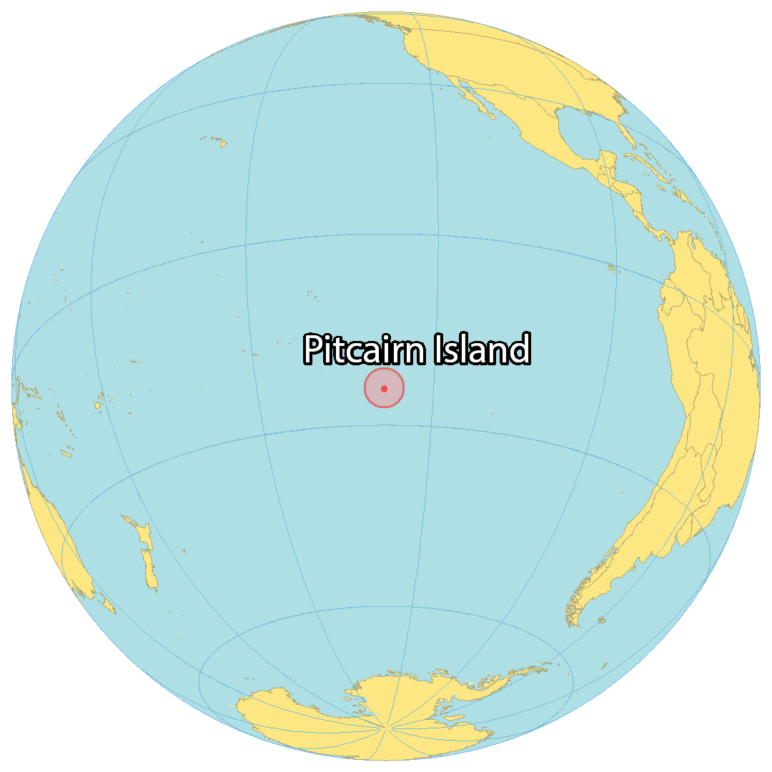
Where is Pitcairn, Henderson, Ducie, and Oeno Islands?
Discovering the Unique Pitcairn Island
Pitcairn Island is a British Overseas Territory located in the South Pacific Ocean. It is made up of four separate islands – Pitcairn, Henderson, Ducie, and Oeno Islands – that are separated by hundreds of kilometers in distance and contain a combined 47 square kilometers (18 sq mi) of area. Henderson is the largest island, accounting for 86% of the total area, and is a UNESCO World Heritage Site – although it is completely uninhabited. The only settlement is on the island of Pitcairn, Adamstown, which is also the capital.
The population of Pitcairn Island is less than 100 people, making it the least populous national jurisdiction in the world. The islands are of volcanic origin and do not have any airports. Access to Pitcairn Island is only possible by boat through Bounty Bay, as the island does not have any permanent water source.
High Definition Political Map of Pitcairn, Henderson, Ducie, and Oeno Islands
History
Polynesian settlement and extinction
The earliest known settlers of the Pitcairn Islands were Polynesians who appear to have lived on Pitcairn and Henderson, and on Mangareva Island 540 kilometres (340 mi) to the northwest, for several centuries from at least the 11th century. They traded goods and formed social ties among the three islands despite the long canoe voyages between them, which helped the small populations on each island survive despite their limited resources. Eventually, important natural resources were exhausted, inter-island trade broke down and a period of civil war began on Mangareva, causing the small human populations on Henderson and Pitcairn to be cut off and eventually to become extinct.
Although archaeologists believe that Polynesians were living on Pitcairn as late as the 15th century, the islands were uninhabited when they were rediscovered by Europeans.
European arrival
Portuguese sailor Pedro Fernandes de Queirós came upon Ducie and Henderson Islands while sailing for the Spanish Crown, arriving on 26 January 1606. He named them La Encarnación (“The Incarnation”) and San Juan Bautista (“Saint John the Baptist”), respectively. However, some sources express doubt about exactly which of the islands were visited and named by Queirós, suggesting that La Encarnación may actually have been Henderson Island, and San Juan Bautista may have been Pitcairn Island.
Pitcairn Island was sighted on 3 July 1767 by the crew of the British sloop HMS Swallow, commanded by Captain Philip Carteret. The island was named after midshipman Robert Pitcairn, a 15-year-old crew member who was the first to sight the island. Robert Pitcairn was a son of British Marine Major John Pitcairn, who was later killed at the 1775 Battle of Bunker Hill in the American War of Independence.
Carteret, who sailed without the newly invented marine chronometer, charted the island at 25°02′S 133°21′W / 25.033°S 133.350°W / -25.033; -133.350, and although the latitude was reasonably accurate, his recorded longitude was incorrect by about 3°, putting his coordinates 330 km (210 mi) to the west of the actual island. This made Pitcairn difficult to find, as highlighted by the failure of captain James Cook to locate the island in July 1773.
European settlement
In 1790, nine of the mutineers from the Bounty, along with the native Tahitian men and women who were with them (six men, 11 women, and a baby girl), settled on Pitcairn Island and set fire to the Bounty. The inhabitants of the island were well aware of the Bounty‘s location, which is still visible underwater in Bounty Bay, but the wreckage gained significant attention in 1957 when documented by National Geographic explorer Luis Marden. Although the settlers survived by farming and fishing, the initial period of settlement was marked by serious tensions among them. Alcoholism, murder, disease and other ills took the lives of most mutineers and Tahitian men. John Adams and Ned Young turned to the scriptures, using the ship’s Bible as their guide for a new and peaceful society. Young eventually died of an asthmatic infection.
Ducie Island was rediscovered in 1791 by Royal Navy captain Edwards aboard HMS Pandora, while searching for the Bounty mutineers. He named it after Francis Reynolds-Moreton, 3rd Baron Ducie, also a captain in the Royal Navy.
The Pitcairn islanders reported it was not until 27 December 1795 that the first ship since the Bounty was seen from the island, but it did not approach the land and they could not make out the nationality. A second ship appeared in 1801, but made no attempt to communicate with them. A third came sufficiently near to see their house, but did not try to send a boat on shore. Finally, the American sealing ship Topaz, under Mayhew Folger, became the first to visit the island, when the crew spent ten hours on Pitcairn in February 1808. Whalers subsequently became regular visitors to the island. The last recorded whaler to visit was the James Arnold in 1888.
A report of Folger’s discovery was forwarded to the Admiralty, mentioning the mutineers and giving a more precise location of the island: 25°02′S 130°00′W / 25.033°S 130.000°W / -25.033; -130.000. However, this was not known to Sir Thomas Staines, who commanded a Royal Navy flotilla of two ships, HMS Briton and HMS Tagus, which found the island at 25°04′S 130°25′W / 25.067°S 130.417°W / -25.067; -130.417 (by meridian observation) on 17 September 1814. Staines sent a party ashore and wrote a detailed report for the Admiralty. By that time, only one mutineer, John Adams, remained alive. He was granted amnesty for his part in the mutiny.
Henderson Island was rediscovered on 17 January 1819 by British Captain James Henderson of the British East India Company ship Hercules. Captain Henry King, sailing on Elizabeth, landed on 2 March to find the king’s colours already flying. His crew scratched the name of their ship into a tree. Oeno Island was discovered on 26 January 1824 by American captain George Worth aboard the whaler Oeno.
In 1832, having tried and failed to petition the British government and the London Missionary Society, Joshua Hill, an American adventurer, arrived. He reported that by March 1833, he had founded a Temperance Society to combat drunkenness, a “Maundy Thursday Society”, a monthly prayer meeting, a juvenile society, a Peace Society and a school.
British colony
Traditionally, Pitcairn Islanders consider that their islands officially became a British colony on 30 November 1838, at the same time becoming one of the first territories to extend voting rights to women. By the mid-1850s, the Pitcairn community was outgrowing the island; its leaders appealed to the British government for assistance, and were offered Norfolk Island. On 3 May 1856, the entire population of 193 people set sail for Norfolk on board the Morayshire, arriving on 8 June after a difficult five-week trip. However, just 18 months later, 17 of the Pitcairn Islanders returned to their home island, and another 27 followed five years later.
HMS Thetis visited Pitcairn Island on 18 April 1881 and “found the people very happy and contented, and in perfect health”. At that time the population was 96, an increase of six since the visit of Admiral de Horsey in September 1878. Stores had recently been delivered from friends in England, including two whale-boats and Portland cement, which was used to make the reservoir watertight. HMS Thetis gave the islanders 200 lb (91 kg) of biscuits, 100 lb (45 kg) of candles, and 100 lb of soap and clothing to the value of £31, donated by the ship’s company. An American trading ship called Venus had in 1882 bestowed a supply of cotton seed, to provide the islanders with a crop for future trade.
In 1886, the Seventh-day Adventist layman John Tay visited Pitcairn and persuaded most of the islanders to accept his faith. He returned in 1890 on the missionary schooner Pitcairn with an ordained minister to perform baptisms. Since then, the majority of Pitcairn Islanders have been Adventists.
The islands of Henderson, Oeno and Ducie were annexed by Britain in 1902: Henderson on 1 July, Oeno on 10 July, and Ducie on 19 December. In 1938, the three islands, along with Pitcairn, were incorporated into a single administrative unit called the “Pitcairn Group of Islands”. The population peaked at 233 in 1937. It has since decreased owing to emigration, primarily to Australia and New Zealand.
Sexual abuse in modern times
Three cases of imprisonment for sex with underage girls were reported in the 1950s.
In 1999, Gail Cox, a police officer from Kent, UK, served on a temporary assignment on Pitcairn, and began uncovering allegations of sexual abuse. When a 15-year-old girl decided to press rape charges in 1999, criminal proceedings (code-named “Operation Unique”) were set in motion. The charges include 21 counts of rape, 41 of indecent assault, and two of gross indecency with a child under 14. Over the following two years, police officers in Australia, New Zealand and the United Kingdom interviewed every woman who had lived on Pitcairn in the past 20 years, as well as all of the accused men. The file was held by Pitcairn’s first Public Prosecutor Simon Moore, an Auckland Crown Solicitor appointed to the position by the British government for the purposes of the investigation.
Australian Seventh-day Adventist pastor Neville Tosen, who spent two years on Pitcairn around the turn of the millennium, said that on his arrival, he had been taken aback by the conduct of the children, but he had not immediately realised what was happening. “I noticed worrying signs such as inexplicable mood swings,” he said. “It took me three months to realise they were being abused.” Tosen tried to bring the matter before the Island Council (the legislative body which doubles as the island’s court), but was rebuffed. One councillor told him, “Look, the age of consent has always been 12 and it doesn’t hurt them.”
A study of island records confirmed anecdotal evidence that most girls bore their first child between the ages of 12 and 15. “I think the girls were conditioned to accept that it was a man’s world and once they turned 12, they were eligible,” Tosen said. Mothers and grandmothers were resigned to the situation, telling him that their own childhood experience had been the same; they regarded it as just a part of life on Pitcairn. One grandmother wondered what all the fuss was about. Tosen was convinced, however, that the early sexual experience was very damaging to the girls, outright stating, “They can’t settle or form solid relationships. They did suffer, no doubt about it.”
In 2016, Mike Warren, Pitcairn mayor from 2008 to 2013, was convicted and sentenced to 20 months imprisonment for possession of child pornography.
In 2004, charges were laid against seven men living on Pitcairn and six living abroad. This accounted for nearly a third of the male population, and half of the island’s adult males. After extensive trials, most of the men were convicted, some with multiple counts of sexual encounters with children. On 25 October 2004, six men were convicted, including Steve Christian, the island’s mayor at the time. In 2004, the islanders had about 20 firearms among them, which they surrendered ahead of the sexual assault trials. After the six men lost their final appeal, the British government set up a prison on the island at Bob’s Valley. The men began serving their sentences in late 2006. By 2010, all had served their sentences or been granted home detention status.
Physical Map of Pitcairn, Henderson, Ducie, and Oeno Islands