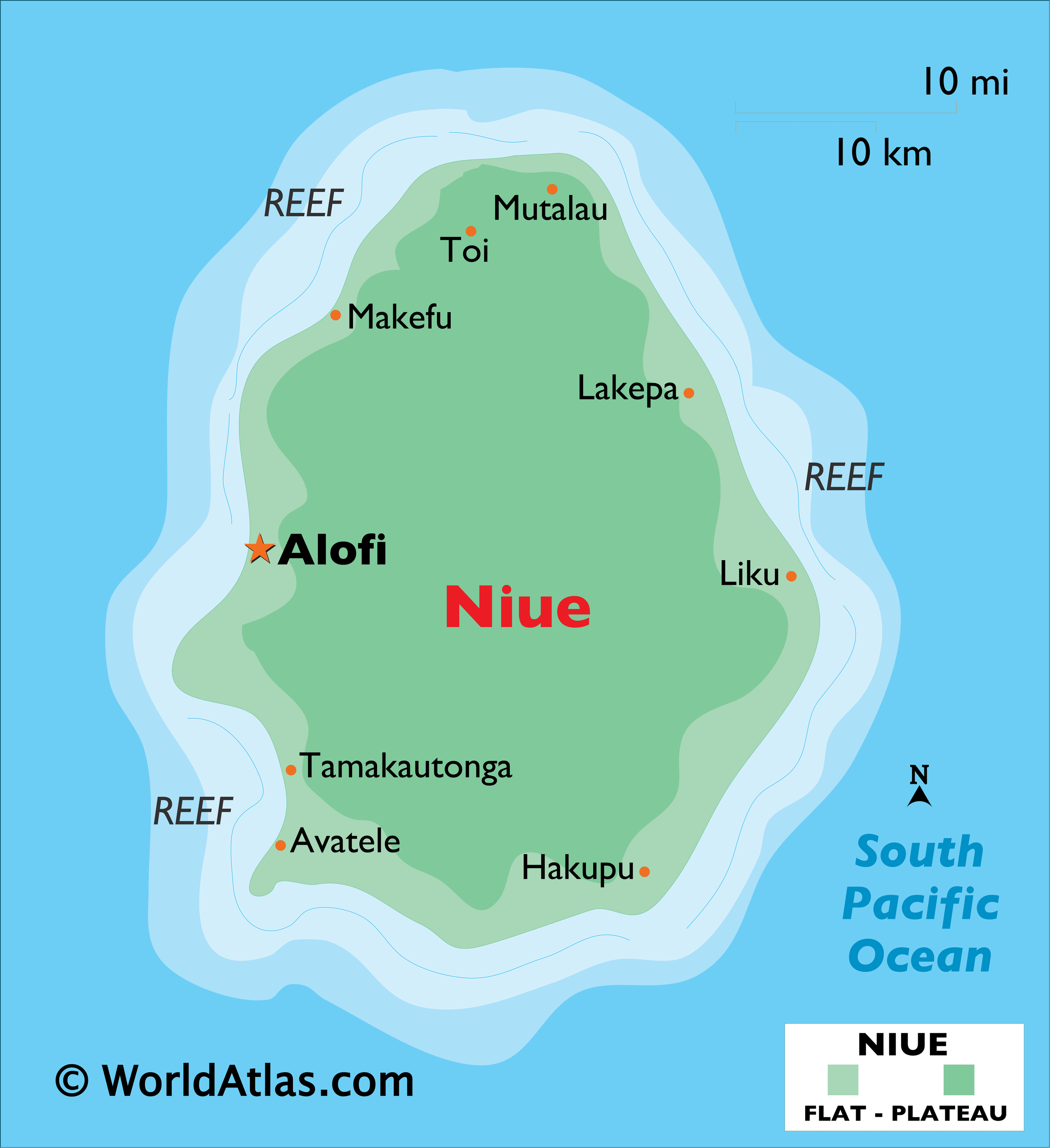
Covering a land area of 261 sq.km (100.95 sq mi), Niue is an island country and a raised coral atoll located in the southwestern Pacific Ocean. Niue is one of the world’s largest coral islands. It consists of steep limestone cliffs lying along the coast, giving way to a central plateau. Two large bays indent the western coast, with Alofi Bay in the center and Avatele Bay in the south. Limestone caves are common close to the coast, and a coral reef almost completely surrounds the island–with the only major break being on the western side, close to Alofi. The highest point is an unnamed elevation near the Mutalau settlement, and it peaks at 223 ft. (68 m). The lowest point is the Pacific Ocean (0m).
| Legal Name: | Niue |
|---|---|
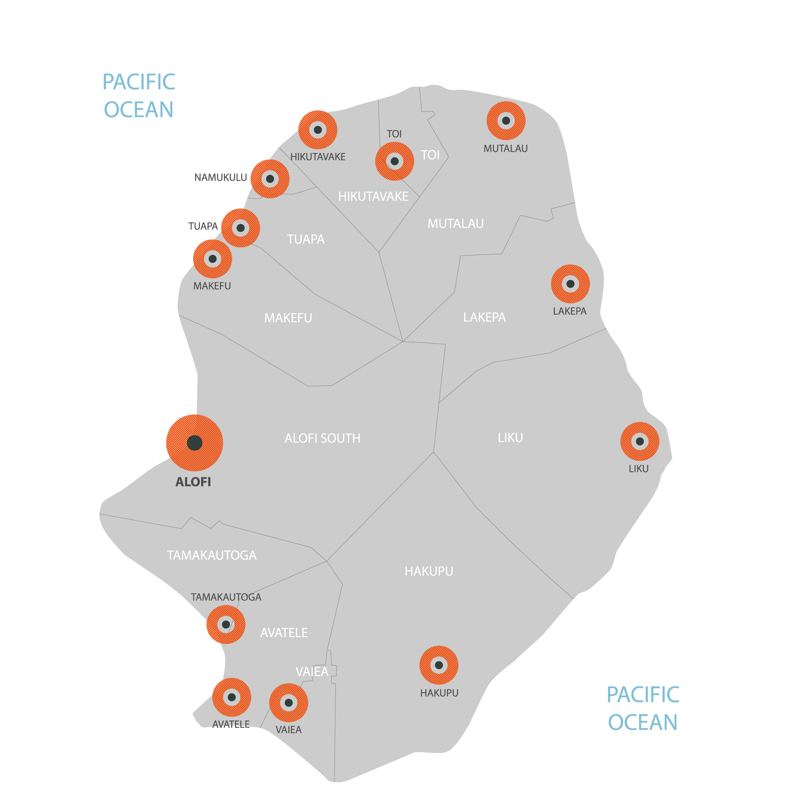
| Capital Value: | Alofi |
| Official languages: |
|
| Demonym(s): | Niuean |
| Government: | Unitary non-partisan parliamentary constitutional monarchy |
| Legislature: | Niue Assembly |
| Total Area: | 260 km² |
| Land Area: | 260 km² |
| Population: | 1,618 |
| Density: | 6.71/km (17.4/sq mi) (not ranked) |
| Currency Value: | New Zealand dollars (NZD) |
| Driving side: | left |
| Calling code: | +683 |
| Internet TLD: | .nu |
Location Maps
Where is Niue?
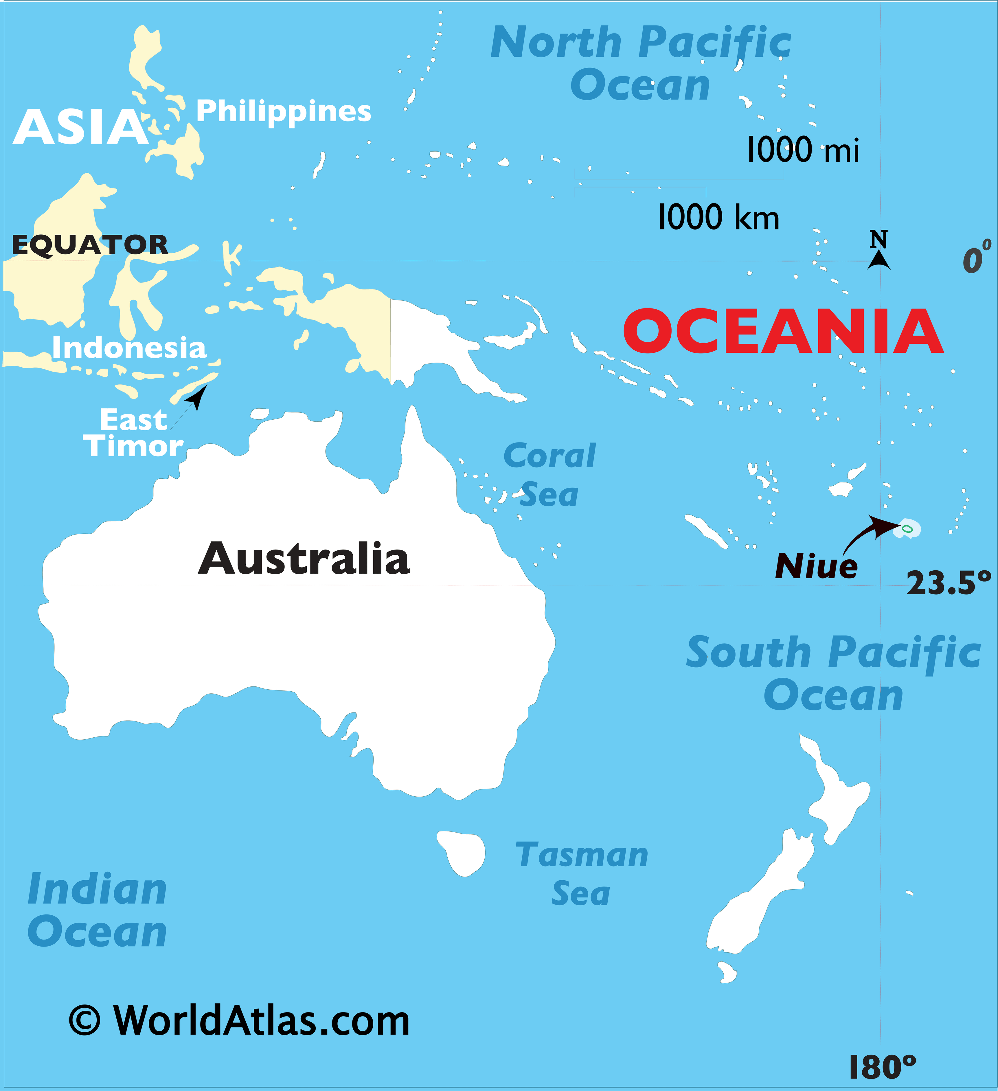
High Definition Political Map of Niue
History
Polynesians from Samoa settled Niue around 900 AD. Further settlers arrived from Tonga in the 16th century.
Until the beginning of the 18th century, Niue appears to have had no national government or national leader; chiefs and heads of families exercised authority over segments of the population. A succession of patu-iki (kings) ruled, beginning with Puni-mata. Tui-toga, who reigned from 1875 to 1887, was the first Christian king.
The first Europeans to sight Niue sailed under Captain James Cook in 1774. Cook made three attempts to land, but the inhabitants refused to grant permission to do so. He named the island “Savage Island” because, as legend has it, the natives who “greeted” him were painted in what appeared to be blood. The substance on their teeth was hulahula, a native red fe’i banana. For the next couple of centuries, Niue was known as Savage Island until its original name, “Niue”, which translates as “behold the coconut”, regained use.
Whaling vessels were some of the most regular visitors to the island in the nineteenth century. The first on record was the Fanny in February 1824. The last known whaler to visit was the Albatross in November 1899.
The next notable European visitors represented the London Missionary Society; they arrived on the Messenger of Peace. After many years of trying to land a European missionary, they abducted a Niuean named Nukai Peniamina and trained him as a pastor at the Malua Theological College in Samoa. Peniamina returned in 1846 on the John Williams as a missionary with the help of Toimata Fakafitifonua. He was finally allowed to land in Uluvehi Mutalau after a number of attempts in other villages had failed. The chiefs of Mutalau village allowed him to land and assigned over 60 warriors to protect him day and night at the fort in Fupiu.
In July 1849 Captain John Erskine visited the island in HMS Havannah.
Christianity was first taught to the Mutalau people before it spread to all the villages. Originally other major villages opposed the introduction of Christianity and had sought to kill Peniamina. The people from the village of Hakupu, although the last village to receive Christianity, came and asked for a “word of God”; hence, their village was renamed “Ha Kupu Atua” meaning “any word of God”, or “Hakupu” for short.
In 1889 the chiefs and rulers of Niue, in a letter to Queen Victoria, asked her “to stretch out towards us your mighty hand, that Niue may hide herself in it and be safe”. After expressing anxiety lest some other nation should take possession of the island, the letter continued: “We leave it with you to do as seems best to you. If you send the flag of Britain that is well; or if you send a Commissioner to reside among us, that will be well”. The British did not initially take up the offer. In 1900 a petition by the Cook Islanders asking for annexation included Niue “if possible”. In a document dated 19 October 1900, the “King” and Chiefs of Niue consented to “Queen Victoria taking possession of this island”. A despatch to the Secretary of State for the Colonies from the Governor of New Zealand referred to the views expressed by the Chiefs in favour of “annexation” and to this document as “the deed of cession”. A British Protectorate was declared, but it remained short-lived. Niue was brought within the boundaries of New Zealand on 11 June 1901 by the same Order and Proclamation as the Cook Islands. The Order limited the islands to which it related by reference to an area in the Pacific described by co-ordinates, and Niue, at 19.02 S., 169.55 W, lies within that area.
The New Zealand Parliament restored self-government in Niue with the 1974 constitution, following a referendum in 1974 in which Niueans had three options: independence, self-government or continuation as a New Zealand territory. The majority selected self-government, and Niue’s written constitution was promulgated as supreme law. Robert Rex, ethnically part European, part native, was elected by the Niue Assembly as the first premier, a position he held until his death 18 years later. Rex became the first Niuean to receive a knighthood – in 1984.
In January 2004 Cyclone Heta hit Niue, killing two people and causing extensive damage to the entire island, including wiping out most of the south of the capital, Alofi.
On March 7, 2020, the International Dark Sky Association announced that Niue had become the first Dark Sky Preserve Nation. On 29 September 2022, President Joe Biden announced that the United States would recognize Niue as a sovereign nation.
Physical Map of Niue
Geography
Niue is a 269 km (104 sq mi) raised coral atoll in the southern Pacific Ocean, east of Tonga. There are three outlying coral reefs within the Exclusive Economic Zone, with no land area:
- Beveridge Reef, 240 km (150 mi) southeast, submerged atoll drying during low tide, 9.5 km (5.9 mi) north-south, 7.5 km (4.7 mi) East-West, total area 56 km (22 sq mi), no land area, lagoon 11 metres (36 ft) deep.
- Antiope Reef, 180 km (110 mi) northeast, a circular plateau approximately 400 metres (1,300 ft) in diameter, with a least depth of 9.5 metres (31 ft).
- Haran Reef (also known as Harans Reef), 294 km (183 mi) southeast.
Besides these, Albert Meyer Reef, (almost 5 km (3.1 mi) long and wide, least depth 3 m (9.8 ft), 326 km (203 mi) southwest) is not officially claimed by Niue, and the existence of Haymet Rocks (1,273 km (791 mi) east-southeast) is in doubt.
Niue is one of the world’s largest coral islands. The terrain consists of steep limestone cliffs along the coast with a central plateau rising to about 60 metres (200 ft) above sea level. A coral reef surrounds the island, with the only major break in the reef being in the central western coast, close to the capital, Alofi. A number of limestone caves occur near the coast.
The island is roughly oval in shape (with a diameter of about 18 kilometres (11 mi)), with two large bays indenting the western coast, Alofi Bay in the centre and Avatele Bay in the south. Between these is the promontory of Halagigie Point. A small peninsula, TePā Point (Blowhole Point), is close to the settlement of Avatele in the southwest. Most of the population resides close to the west coast, around the capital, and in the northwest.
Some of the soils are geochemically very unusual. They are extremely weathered tropical soils, with high levels of iron and aluminium oxides (oxisol) and mercury, and they contain high levels of natural radioactivity. There is almost no uranium, but the radionucleides Th-230 and Pa-231 head the decay chains. This is the same distribution of elements as found naturally on very deep seabeds, but the geochemical evidence suggests that the origin of these elements is extreme weathering of coral and brief sea submergence 120,000 years ago. Endothermal upwelling, by which mild volcanic heat draws deep seawater up through the porous coral, almost certainly contributes.
No adverse health effects from the radioactivity or the other trace elements have been demonstrated, and calculations show that the level of radioactivity is probably much too low to be detected in the population. These unusual soils are very rich in phosphate, but it is not accessible to plants, being in the very insoluble form of iron phosphate, or crandallite. It is thought that similar radioactive soils may exist on Lifou and Mare near New Caledonia, and Rennell in the Solomon Islands, but no other locations are known.
According to the World Health Organization, residents are evidently very susceptible to skin cancer. In 2002 Niue reported skin cancer deaths at a rate of 2,482 per 100,000 people – far higher than any other country.
Niue is separated from New Zealand by the International Date Line. The time difference is 23 hours during the Southern Hemisphere winter and 24 hours when New Zealand uses Daylight Saving Time.
Coral chasm
Niue’s coastline
Natural stone arch
Climate
The island has a tropical rainforest climate (Af) according to the Köppen climate classification with high temperatures and rainfall throughout the year. Although there are no true wet or dry seasons, there is a noticeably wetter stretch from October to May.