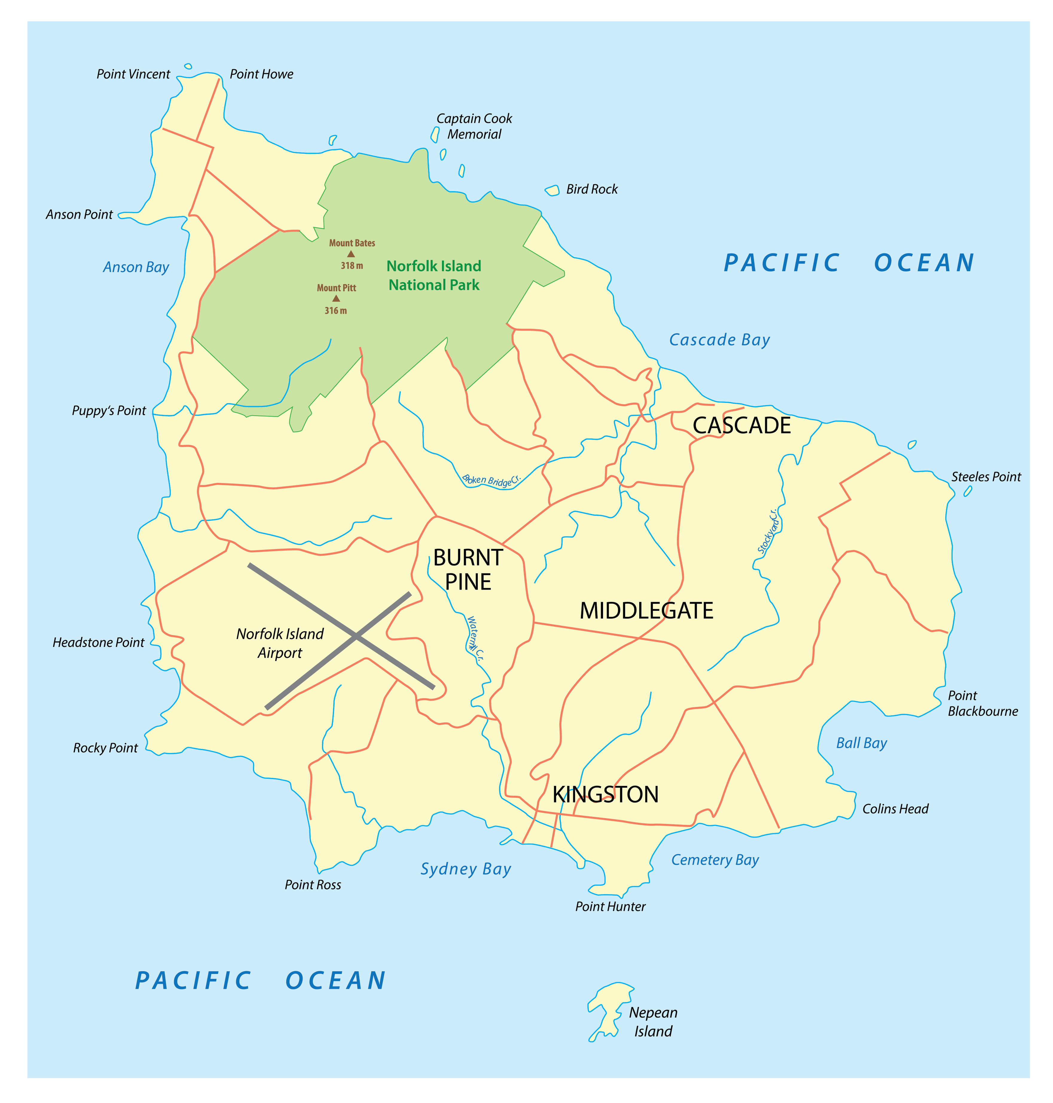
Covering a total land area of only 34.6 sq.km, Norfolk Island is an external territory under Australia located in the South Pacific Ocean. The Norfolk Island is mainly a mountain top remnant of an elongated shield volcano; defined by pine trees and jagged cliffs. Major portion of Norfolk Island is a plateau formed from horizontal sheets of basalt. The highest point of the island is Mount Bates which rises to 319 m above sea level. It is reported that Mount Bates is much higher than its present height as a major part of it is submerged under the waters of the South Pacific Ocean. The lowest point is the South Pacific Ocean (0m).
| Legal Name: | Territory of Norfolk Island |
|---|---|
| Capital Value: | Kingston |
| Official languages: |
|
| Demonym(s): | Norfolk Islander |
| Government: | Directly administered dependency |
| Total Area: | 36 km² |
| Land Area: | 36 km² |
| Population: | 1,748 |
| Density: | 61.9/km (160.3/sq mi) (not ranked) |
| Currency Value: | Australian dollars (AUD) |
| Driving side: | left |
| Calling code: | +672 |
| Internet TLD: | .nf |
Location Maps
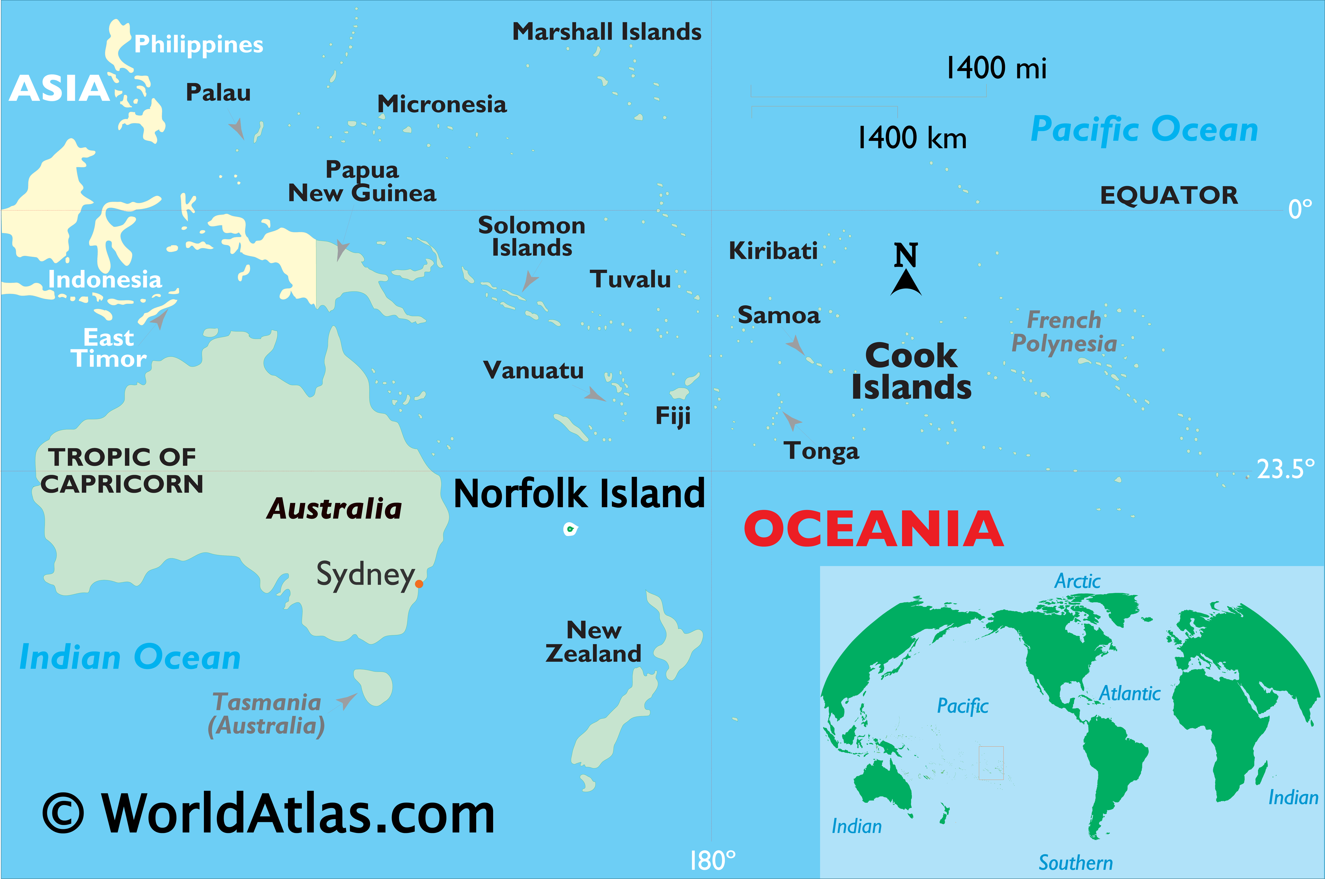
Where is Territory of Norfolk Island?
High Definition Political Map of Territory of Norfolk Island
Physical Map of Territory of Norfolk Island
Geography
The Territory of Norfolk Island is located in the South Pacific Ocean, east of the Australian mainland. Norfolk Island itself is the main island of the island group that the territory encompasses and is located at 29°02′S 167°57′E / 29.033°S 167.950°E / -29.033; 167.950. It has an area of 34.6 square kilometres (13.4 sq mi), with no large-scale internal bodies of water and 32 km (20 mi) of coastline. Norfolk was formed from several volcanic eruptions between 3.1 and 2.3 million years ago.
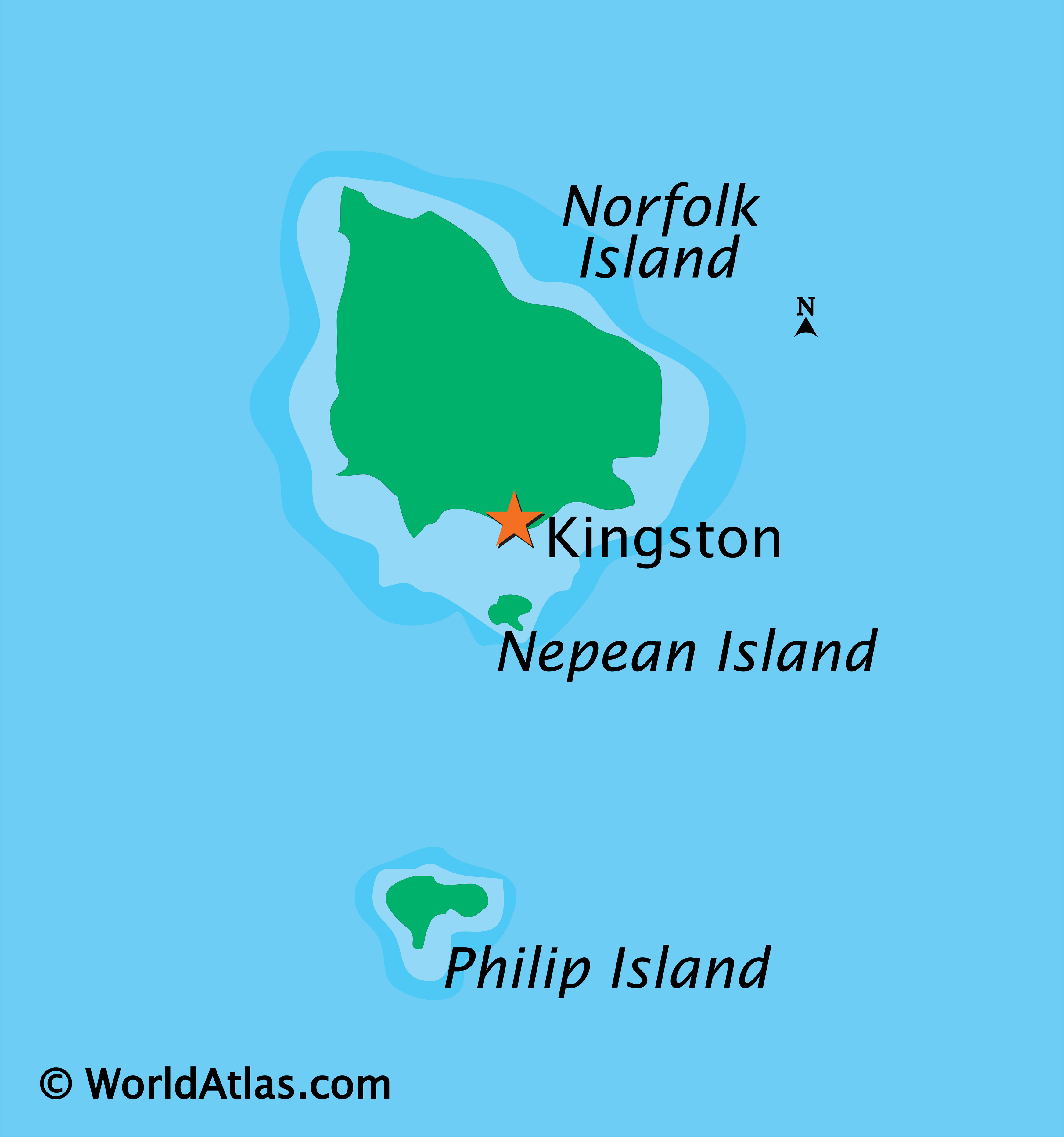
The island’s highest point is Mount Bates reaching 319 metres (1,047 feet) above sea level, located in the northwest quadrant of the island. The majority of the terrain is suitable for farming and other agricultural uses. Phillip Island, the second largest island of the territory, is located at 29°07′S 167°57′E / 29.117°S 167.950°E / -29.117; 167.950, seven kilometres (4.3 miles) south of the main island.
The coastline of Norfolk Island consists, to varying degrees, of cliff faces. A downward slope exists towards Slaughter Bay and Emily Bay, the site of the original colonial settlement of Kingston. There are no safe harbour facilities on Norfolk Island, with loading jetties existing at Kingston and Cascade Bay. All goods not domestically produced are brought in by ship, usually to Cascade Bay. Emily Bay, protected from the Pacific Ocean by a small coral reef, is the only safe area for recreational swimming, although surfing waves can be found at Anson and Ball Bays.
The climate is subtropical and mild, with little seasonal differentiation. The island is the eroded remnant of a basaltic volcano active around 2.3 to 3 million years ago, with inland areas now consisting mainly of rolling plains. It forms the highest point on the Norfolk Ridge, part of the submerged continent Zealandia.
The area surrounding Mount Bates is preserved as the Norfolk Island National Park. The park, covering around 10% of the land of the island, contains remnants of the forests which originally covered the island, including stands of subtropical rainforest.
The park also includes the two smaller islands to the south of Norfolk Island, Nepean Island and Phillip Island. The vegetation of Phillip Island was devastated due to the introduction during the penal era of pest animals such as pigs and rabbits, giving it a red-brown colour as viewed from Norfolk; however, pest control and remediation work by park staff has recently brought some improvement to the Phillip Island environment.
The major settlement on Norfolk Island is Burnt Pine, located predominantly along Taylors Road, where the shopping centre, post office, bottle shop, telephone exchange and community hall are located. Settlement also exists over much of the island, consisting largely of widely separated homesteads.
Government House, the official residence of the Administrator, is located on Quality Row in what was the penal settlement of Kingston. Other government buildings, including the court, Legislative Assembly and Administration, are also located there. Kingston’s role is largely a ceremonial one, however, with most of the economic impetus coming from Burnt Pine.
Climate
Norfolk Island has a mid-latitude and marine subtropical climate (Köppen: Cfa). The temperature never falls below 6 °C (43 °F) or rises above 30 °C (86 °F). The absolute maximum recorded temperature is 28.4 °C (83.1 °F), while the absolute minimum is 6.2 °C (43.2 °F). Average annual precipitation is around 1,100 millimetres (43 in), with most rain falling from April to August. Other months receive significant amounts of precipitation as well.
Environment
Norfolk Island is part of the Interim Biogeographic Regionalisation for Australia region “Pacific Subtropical Islands” (PSI), and forms subregion PSI02, with an area of 3,908 hectares (9,660 acres). The country is home to the Norfolk Island subtropical forests terrestrial ecoregion.
Norfolk Island has 174 native plants; 51 of them are endemic. At least 18 of the endemic species are rare or threatened. The Norfolk Island palm (Rhopalostylis baueri) and the smooth tree-fern (Cyathea brownii), the tallest tree-fern in the world, are common in the Norfolk Island National Park but rare elsewhere on the island. Before European colonisation, most of Norfolk Island was covered with subtropical rain forest, the canopy of which was made of Araucaria heterophylla (Norfolk Island pine) in exposed areas, and the palm Rhopalostylis baueri and tree ferns Cyathea brownii and C. australis in moister protected areas. The understory was thick with lianas and ferns covering the forest floor. Only one small tract, 5 km (1.9 sq mi), of rainforest remains, which was declared as the Norfolk Island National Park in 1986.
This forest has been infested with several introduced plants. The cliffs and steep slopes of Mount Pitt supported a community of shrubs, herbaceous plants, and climbers. A few tracts of cliff top and seashore vegetation have been preserved. The rest of the island has been cleared for pasture and housing. Grazing and introduced weeds currently threaten the native flora, displacing it in some areas. In fact, there are more weed species than native species on Norfolk Island.
As a relatively small and isolated oceanic island, Norfolk has few land birds but a high degree of endemicity among them. Norfolk Island is home to a radiation of about 40 endemic snail species. Many of the endemic bird species and subspecies have become extinct as a result of massive clearance of the island’s native vegetation of subtropical rainforest for agriculture, hunting and persecution as agricultural pests. The birds have also suffered from the introduction of mammals such as rats, cats, pigs and goats, as well as from introduced competitors such as common blackbirds and crimson rosellas. Although the island is politically part of Australia, many of Norfolk Island’s native birds show affinities to those of neighbouring New Zealand, such as the Norfolk kaka, Norfolk pigeon, and Norfolk boobook.
Extinctions include that of the endemic Norfolk kaka, Norfolk ground dove and Norfolk pigeon, while of the endemic subspecies the starling, triller, thrush and boobook owl are extinct, although the latter’s genes persist in a hybrid population descended from the last female. Other endemic birds are the white-chested white-eye, which may be extinct, the Norfolk parakeet, the Norfolk gerygone, the slender-billed white-eye and endemic subspecies of the Pacific robin and golden whistler. Subfossil bones indicate that a species of Coenocorypha snipe was also found on the island and is now extinct, but the taxonomic relationships of this are unclear and have not been scientifically described yet.
The Norfolk Island Group Nepean Island is also home to breeding seabirds. The providence petrel was hunted to local extinction by the beginning of the 19th century but has shown signs of returning to breed on Phillip Island. Other seabirds breeding there include the white-necked petrel, Kermadec petrel, wedge-tailed shearwater, Australasian gannet, red-tailed tropicbird and grey ternlet. The sooty tern (known locally as the whale bird) has traditionally been subject to seasonal egg harvesting by Norfolk Islanders.
Norfolk Island, with neighbouring Nepean Island, has been identified by BirdLife International as an Important Bird Area because it supports the entire populations of white-chested and slender-billed white-eyes, Norfolk parakeets and Norfolk gerygones, as well as over 1% of the world populations of wedge-tailed shearwaters and red-tailed tropicbirds. Nearby Phillip Island is treated as a separate IBA.
Norfolk Island also has a botanical garden, which is home to a sizeable variety of plant species. However, the island has only one native mammal, Gould’s wattled bat (Chalinolobus gouldii). It is very rare, and may already be extinct on the island.
The Norfolk swallowtail (Papilio amynthor) is a species of butterfly that is found on Norfolk Island and the Loyalty Islands.
Cetaceans were historically abundant around the island as commercial hunts on the island were operating until 1956. Today, numbers of larger whales have disappeared, but even today many species such humpback whale, minke whale, sei whale, and dolphins can be observed close to shore, and scientific surveys have been conducted regularly. Southern right whales were once regular migrants to Norfolk, but were severely depleted by historical hunts, and further by recent illegal Soviet and Japanese whaling, resulting in none or very few, if remnants still live, right whales in these regions along with Lord Howe Island.
Whale sharks can be encountered off the island, too.
Gannet
Masked boobies
White tern
Emily Bay
Norfolk Island pines
Captain Cook Lookout
Bird Rock (off the north coast)
Cathedral Rock (off the north coast)
- Norfolk parakeet, Cyanoramphus cookii (endangered)
- Norfolk kaka, Nestor productus (extinct)
- Brown goshawk, Accipiter fasciatus (extirpated)
- Norfolk pigeon, Hemiphaga novaseelandiae spadicea (extinct, subspecies of NZ pigeon)
- Norfolk ground dove, Aloepecoenas norfolkensis (extinct)
- Norfolk snipe, Coenocorypha spp. (extinct, undescribed)
- Norfolk rail, Gallirallus spp. (extinct, undescribed)
- Norfolk robin, Petroica multicolor (endangered)
- Norfolk golden whistler, Pachycephala pectoralis xanthoprocta (vulnerable, subspecies of golden whistler)
- Norfolk triller, Lalage leucopyga leucopyga (extinct, nominate subspecies of long-tailed triller)
- Norfolk Island thrush, Turdus poliocephalus poliocephalus (extinct, nominate subspecies of Island thrush)
- Norfolk Island starling, Aplonis fusca fusca (extinct, nominate subspecies of extinct Tasman starling)
- Norfolk boobook, Ninox novaeseelandiae undulata (extinct except for hybrids with nominate subspecies, subspecies of MoreporkSouthern boobook)
- White-chested white-eye, Zosterops albogularis (critically endangered, possibly extinct)
- Slender-billed white-eye, Zosterops tenuirostris (near threatened)
- Norfolk gerygone, Gerygone modesta (near threatened)
- Norfolk grey fantail, Rhiphidura albiscapa pelzelni (least concern, subspecies of grey fantail)
- Norfolk petrel, Pterodroma spp. (extinct, undescribed)