Map of Isle of Man

Map of Isle of Man

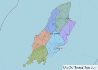
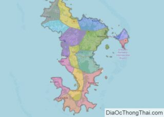
The Isle of Man (Manx: Mannin [ˈmanɪnʲ], also Ellan Vannin [ˈɛlʲan ˈvanɪnʲ]), also known as Mann (/mæn/), is a self-governing Crown Dependency in the Irish Sea between Great Britain and Ireland. As head of state, Charles III holds the title Lord of Mann and is represented by a Lieutenant Governor. The government of the United … Read more

Map of Jersey

Map of Jersey

Jersey (/ˈdʒɜːrzi/; Jèrriais: Jèrri [ʒɛri]), officially the Bailiwick of Jersey, is an island country and self-governing British Crown Dependency near the coast of north-west France. It is the largest of the Channel Islands and is 14 miles (23 km) from the Cotentin Peninsula in Normandy. The Bailiwick consists of the main island of Jersey and some … Read more

Map of Kosovo

Map of Kosovo

Kosovo (Albanian: Kosova [kɔˈsɔva] or Kosovë [kɔˈsɔvə]; Serbian Cyrillic: Косово [kôsoʋo]), officially the Republic of Kosovo (Albanian: Republika e Kosovës; Serbian: Република Косово, romanized: Republika Kosovo), is a partially recognised state in Southeast Europe. It lies at the centre of the Balkans. Kosovo unilaterally declared its independence from Serbia on 17 February 2008, and has since … Read more

Map of Martinique

Map of Martinique

Martinique (/ˌmɑːrtɪˈniːk/ MAR-tin-EEK, French: [maʁtinik] (listen); Martinican Creole: Matinik or Matnik; Kalinago: Madinina or Madiana) is an island which is a single territorial collectivity of the French Republic. It is also part of the European Union as an Outermost Region within the Special territories of members of the European Economic Area, but is not part of … Read more

Map of Mayotte

Map of Mayotte

Mayotte (/maɪˈɒt/; French: Mayotte, [majɔt]; Shimaore: Maore, IPA: [maˈore]; Kibushi: Maori, IPA: [maˈori]), officially the Department of Mayotte (French: Département de Mayotte), is an overseas department and region and single territorial collectivity of France. It is located in the northern part of the Mozambique Channel in the Indian Ocean off the coast of Southeastern Africa, between Northwestern … Read more

Map of Réunion

Map of Réunion

Covering an area of 2,511 sq. km, Reunion Island is an overseas department and a region of France located in the Indian Ocean. As observed on the map, Reunion is a rugged volcanic island and consists of rugged mountains that are dissected by short rivers. Located in the west-central part of the Island is the … Read more

Map of Saint Helena

Map of Saint Helena

Saint Helena (/həˈliːnə/) is a British overseas territory located in the South Atlantic Ocean. It is a remote volcanic tropical island 1,950 kilometres (1,210 miles) west of the coast of south-western Africa, and 4,000 kilometres (2,500 mi) east of Rio de Janeiro in South America. It is one of three constituent parts of the British Overseas … Read more

Map of Saint Martin

Map of Saint Martin

Saint Martin (French: Saint-Martin; Dutch: Sint Maarten) is an island in the northeast Caribbean Sea, approximately 300 km (190 mi) east of Puerto Rico. The 87 square kilometres (34 sq mi) island is divided roughly 60:40 between the French Republic (53 square kilometres (20 sq mi)) and the Kingdom of the Netherlands (34 square kilometres (13 sq mi)), but the Dutch part is … Read more

Map of Saint Pierre and Miquelon

Map of Saint Pierre and Miquelon

Saint Pierre and Miquelon (/ˈmɪkəlɒn/), officially the Territorial Collectivity of Saint-Pierre and Miquelon (French: Collectivité territoriale de Saint-Pierre et Miquelon [sɛ̃ pjɛʁ e miklɔ̃]), is a self-governing territorial overseas collectivity of France in the northwestern Atlantic Ocean near the Canadian province of Newfoundland and Labrador. An archipelago of eight islands, Saint Pierre and Miquelon is … Read more

Map of Somaliland

Map of Somaliland

Somaliland, officially the Republic of Somaliland, is an unrecognised de facto sovereign state in the Horn of Africa, still considered internationally to be part of Somalia. Somaliland lies in the Horn of Africa, on the southern coast of the Gulf of Aden. It is bordered by Djibouti to the northwest, Ethiopia to the south and … Read more

Map of Saint Barthélemy

Map of Saint Barthélemy

Saint Barthélemy (French: Saint-Barthélemy, [sɛ̃ baʁtelemi] (listen)), officially the Collectivité territoriale de Saint-Barthélemy, also known as St. Barts (English) or St. Barth (French), is an overseas collectivity of France in the Caribbean. The island lies about 30 kilometres (19 mi) southeast of the island of Saint Martin; it is northeast of the Dutch islands of Saba … Read more

Map of U.S. Minor Outlying Islands

Map of U.S. Minor Outlying Islands

The United States Minor Outlying Islands is a statistical designation defined by the International Organization for Standardization’s ISO 3166-1 code. The entry code is ISO 3166-2:UM. The minor outlying islands and groups of islands consist of eight United States insular areas in the Pacific Ocean (Baker Island, Howland Island, Jarvis Island, Johnston Atoll, Kingman Reef, … Read more