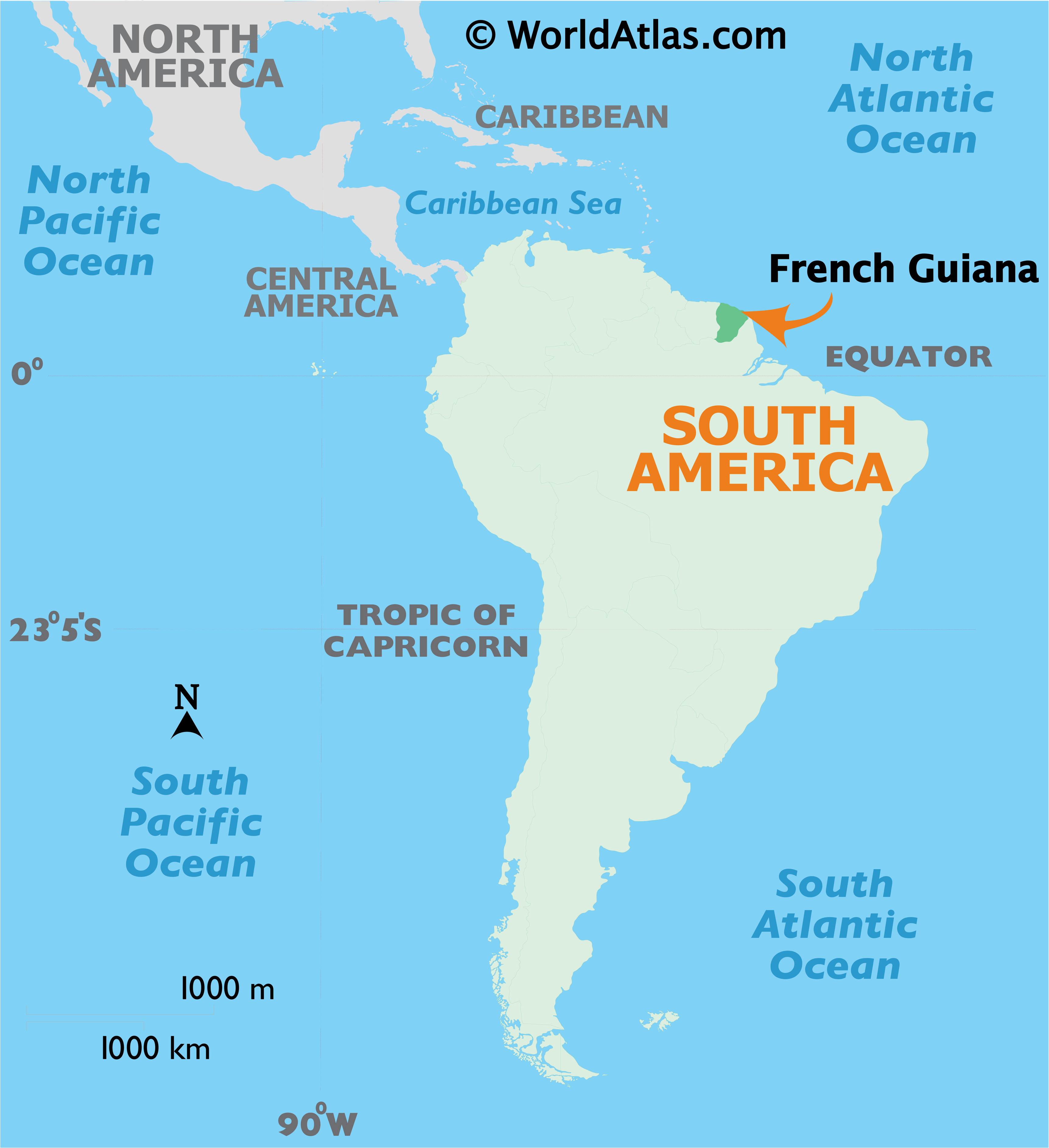
Covering an area of 83,534 sq. km, French Guiana located in the northeastern edge of South America, is France’s 2nd largest region.
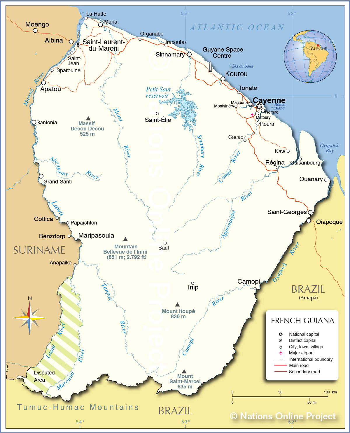
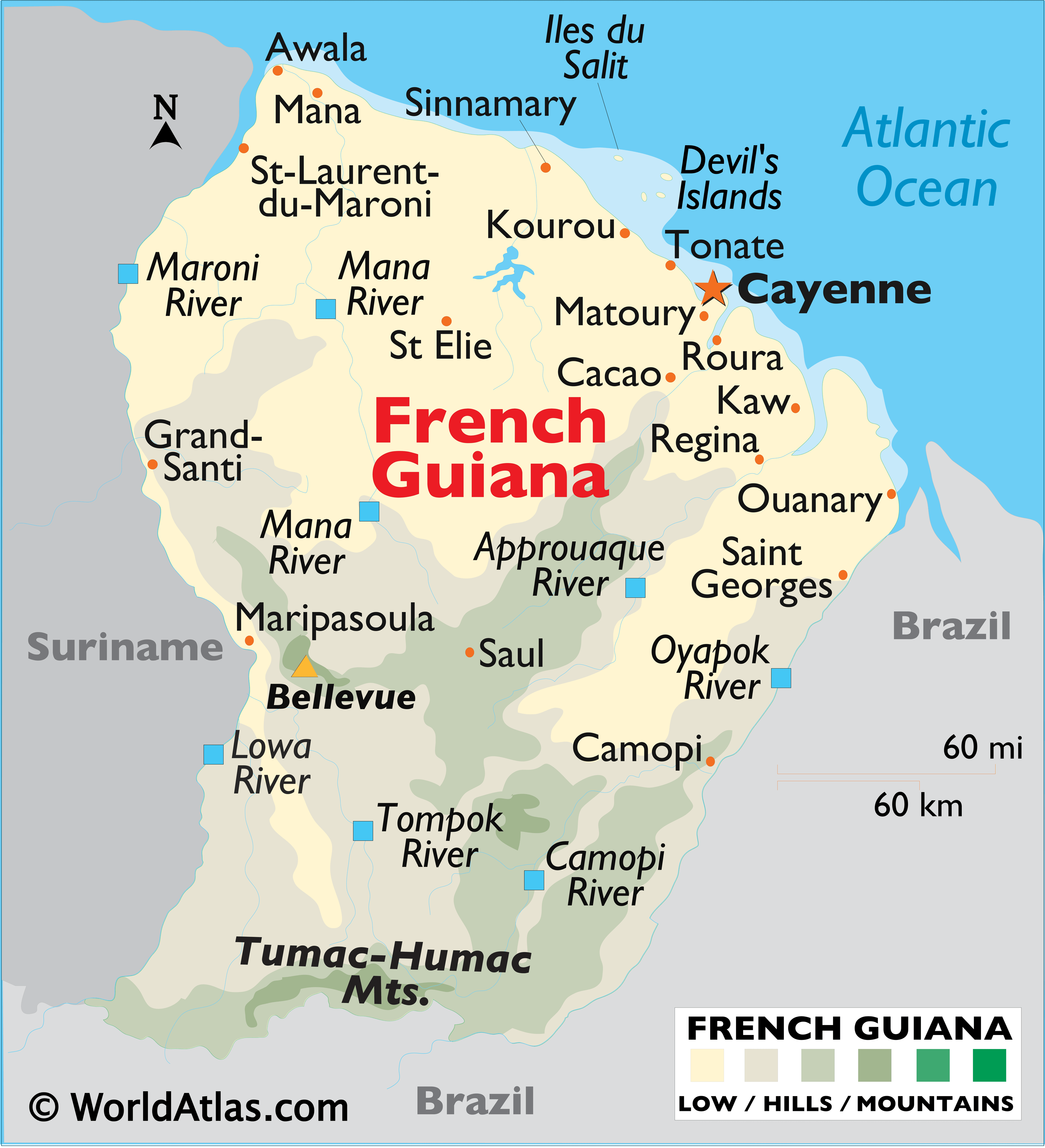
A narrow coastal strip fronts the Atlantic Ocean coastline of French Guiana. To the south, the land is an unsettled wilderness, covered by a dense jungle and parts of the Amazon Rain Forest, that is dissected by dozens and dozens of rivers. Offshore islands include Iles du Salut (and Devil’s Island).
As observed on the map, French Guinea is a land of rivers – many of them, flowing north from the southern mountains. The major ones include the Maroni and Lawa, forming its (disputed) border with Suriname; the Oyapok, forming a long natural border with Brazil, and the Approuaque, Camopi, Mana, and Tompok Rivers. The Barrage de Petit-Saut hydroelectric dam in the far north eventually formed a large artificial lake to the northeast of St Elie.
The land of French Guiana begins to gently rise in the central regions of the country, ending at the base of the Tumac-Humac Mountains, along its southern border with Brazil. The highest point in French Guiana, as marked by an upright yellow triangle is, Bellevue de l’lnini, which rises to an elevation of 2,792 ft. (851m). The lowest point is the Atlantic Ocean (0m).
| Demonym(s): | (French) Guianan (French) Guianese |
|---|---|
| Legislature: | Assembly of French Guiana |
| Density: | 3.6/km (9.3/sq mi) |
Online Interactive Political Map
Click on ![]() to view map in "full screen" mode.
to view map in "full screen" mode.
French Guiana – an overseas region and department of France is, divided into two arrondissements, 19 cantons and a total of 22 communes (towns and villages). Cayenne and Saint-Laurent Du Maroni are the two arrondissements. Saint-Laurent Du Maroni has 8 communes and Cayenne has 14 communes.
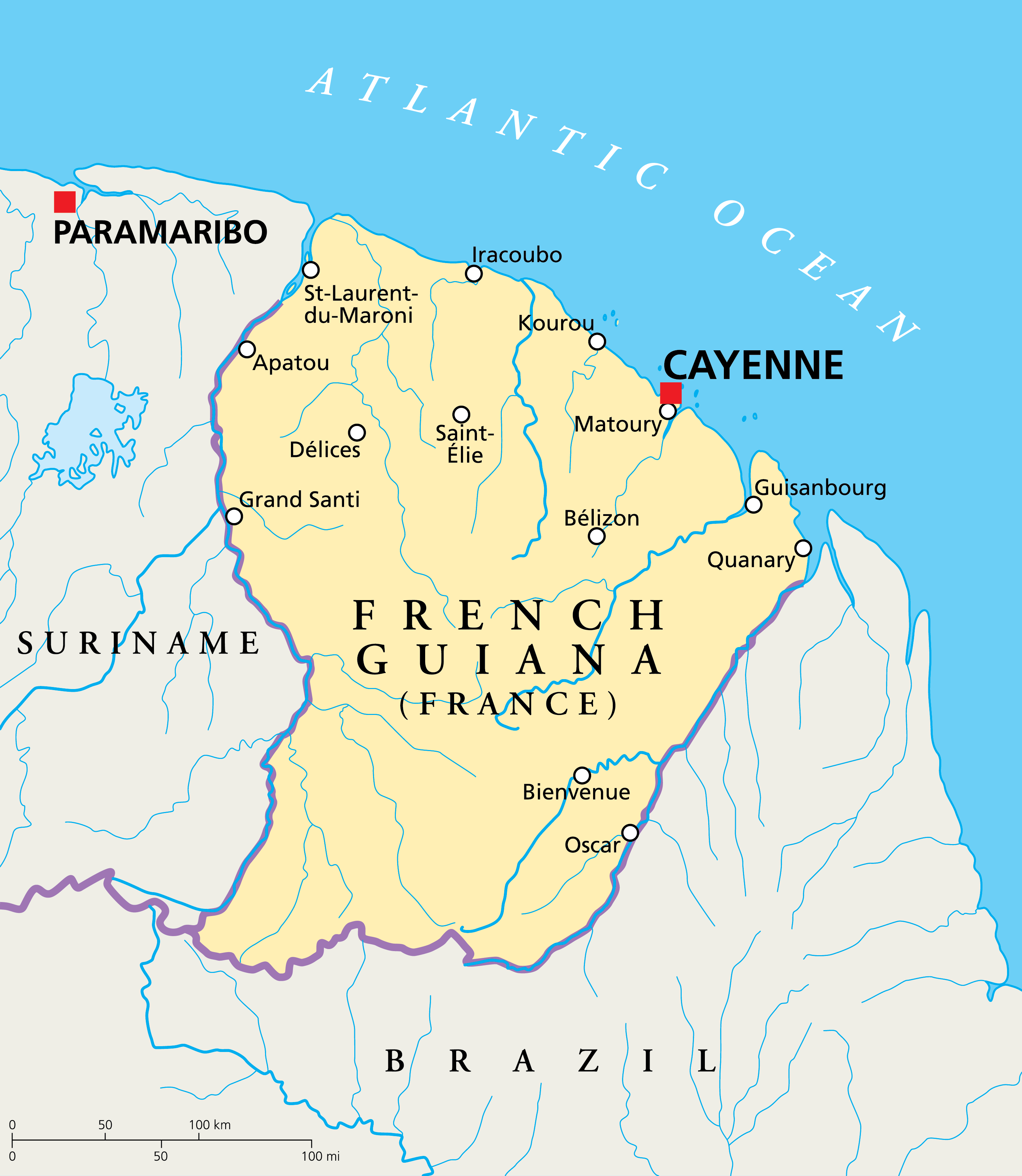
Covering an area of 83,534 sq. km, French Guiana is France’s 2nd largest region. Located in the northwestern corner of the Island of Cayenne at the Cayenne River Estuary is Cayenne – the capital (prefecture) city of French Guiana.
Location Maps
Where is French Guiana?
High Definition Political Map of French Guiana
History
French Guiana was originally inhabited by indigenous people: Kalina, Arawak, Galibi, Palikur, Teko, Wayampi and Wayana. The French attempted to create a colony there in the 16th century in conjunction with its settlement of some Caribbean islands, such as Guadeloupe and Saint-Domingue.
Prior to European colonization, the territory was originally inhabited by Native Americans, most speaking the Arawak language, of the Arawakan language family. The people identified as Lokono. The first French establishment is recorded in 1503, but France did not establish a durable presence until colonists founded Cayenne in 1643. Guiana was developed as a slave society, where planters imported Africans as enslaved labourers on large sugar and other plantations in such number as to increase the population. The system of slavery in French Guiana continued until the French Revolution, when the National Convention voted to abolish the French slave trade and slavery in France’s overseas colonies in February 1794, months after enslaved Haitians had started a slave rebellion in the colony of Saint-Domingue. However, the 1794 decree was only implemented in Saint-Domingue, Guadeloupe and French Guiana, while the colonies of Senegal, Mauritius, Réunion and Martinique and French India resisted the imposition of these laws.
Bill Marshall, Professor of Comparative Cultural Studies at the University of Stirling wrote of French Guiana’s origins:
Île du Diable (Devil’s Island) was the site of a small prison facility, part of a larger penal system by the same name, which consisted of prisons on three islands and three larger prisons on the mainland. This was operated from 1852 to 1953.
In addition, in the late nineteenth century, France began requiring forced residencies by prisoners who survived their hard labour. A Portuguese-British naval squadron took French Guiana for the Portuguese Empire in 1809. It was returned to France with the signing of the Treaty of Paris in 1814. Though Portugal returned the region to France, it kept a military presence until 1817.
After French Guiana was established as a penal colony, officials sometimes used convicts to catch butterflies. The sentences of the convicts were often long, and the prospect of employment very weak, so the convicts caught butterflies to sell in the international market, both for scientific purposes as well as general collecting.
A border dispute with Brazil arose in the late 19th century over a vast area of jungle, resulting in the short-lived, pro-French, independent state of Counani in the disputed territory. There was some fighting among settlers. The dispute was resolved largely in favour of Brazil by the arbitration of the Swiss government.
The territory of Inini consisted of most of the interior of French Guiana when it was created in 1930. It was abolished in 1946, the year that French Guiana as a whole was formally established as an overseas department of France. In 1936, Félix Éboué from Cayenne became the first black man to serve as governor in a French colony.
During World War II and the fall of France to Nazi German forces, French Guiana became part of Vichy France. Guiana officially rallied to Free France on 16 March 1943. It abandoned its colony status and once again became a French department on 19 March 1946.
Following the French withdrawal from Vietnam in the 1950s and subsequent warfare conducted in the region by the United States, France helped resettle several hundred Hmong refugees from Laos to French Guiana during the 1970s and 80s, who were fleeing displacement after the communist takeover of Laos by Pathet Lao in 1975.
In the late 1980s, more than 10,000 Surinamese refugees, mostly Maroons, arrived in French Guiana, fleeing the Surinamese Civil War.
More recently, French Guiana has received large numbers of Brazilian and Haitian economic migrants. Illegal and ecologically destructive gold mining by Brazilian garimpeiros is a chronic issue in the remote interior rain forest of French Guiana. The region still faces such problems as illegal immigration, poorer infrastructure than mainland France, higher costs of living, higher levels of crime and more common social unrest.
In 1964, French president Charles de Gaulle decided to construct a space-travel base in French Guiana. It was intended to replace the Sahara base in Algeria and stimulate economic growth in French Guiana. The department was considered suitable for the purpose because it is near the equator and has extensive access to the ocean as a buffer zone. The Guiana Space Centre, located a short distance along the coast from Kourou, has grown considerably since the initial launches of the Véronique rockets. It is now part of the European space industry and has had commercial success with such launches as the Ariane 4, Ariane 5 and Ariane flight VA256 which launched the James Webb Space Telescope into space.
The Guianese General Council officially adopted a departmental flag in 2010. In a referendum that same year, French Guiana voted against autonomy.
On 20 March 2017, French Guianese workers began going on strike and demonstrating for more resources and infrastructure. 28 March 2017 was the day of the largest demonstration ever held in French Guiana.
French Guiana has been severely affected by the COVID-19 outbreak, with more than 1% of French Guianese testing positive by the end of June 2020.
Physical Map of French Guiana
Geography
French Guiana lies between latitudes 2° and 6° N, and longitudes 51° and 55° W. It consists of two main geographical regions: a coastal strip where the majority of the people live, and dense, near-inaccessible rainforest which gradually rises to the modest peaks of the Tumuc-Humac mountains along the Brazilian frontier. French Guiana’s highest peak is Bellevue de l’Inini in Maripasoula (851 m, 2,792 ft). Other mountains include Mont Itoupé (826 m, 2,710 ft), Cottica Mountain (744 m, 2,441 ft), Pic Coudreau (711 m, 2,333 ft), and Kaw Mountain (337 m, 1,106 ft).
Several small islands are found off the coast: the three Salvation’s Islands which include Devil’s Island, and the isolated Îles du Connétable bird sanctuary further along the coast towards Brazil.
The Petit-Saut Dam, a hydroelectric dam in the north of French Guiana forms an artificial lake and provides hydroelectricity. There are many rivers in French Guiana, including the Waki River.
As of 2007, the Amazonian forest, located in the most remote part of the department, is protected as the Guiana Amazonian Park, one of the ten national parks of France. The territory of the park covers some 33,900 km (13,090 sq mi) upon the communes of Camopi, Maripasoula, Papaïchton, Saint-Élie and Saül.
Climate
French Guiana has an equatorial climate predominant. Located within six degrees of the Equator and rising only to modest elevations, French Guiana is hot and oppressively humid all year round. During most of the year, rainfall across the country is heavy due to the presence of the Intertropical Convergence Zone and its powerful thunderstorm cells. In most parts of French Guiana, rainfall is always heavy especially from December to July – typically over 330 millimetres or 13 inches can be expected each month during this period throughout the department. Between August and November, the eastern half experiences a warm dry season with rainfall below 100 millimetres or 3.94 inches and average high temperatures above 30 °C (86 °F) occurring in September and October, causing eastern French Guiana to be classified as a tropical monsoon climate (Köppen Am); Saint-Laurent-du-Maroni in the west has a tropical rainforest climate (Af).
Environment
French Guiana is home to many different ecosystems: tropical rainforests, coastal mangroves, savannahs, inselbergs and many types of wetlands. It lies within three ecoregions: Guayanan Highlands moist forests, Guianan moist forests, and Guianan mangroves. French Guiana has a high level of biodiversity of both flora and fauna. This is due to the presence of old-growth forests (i.e., ancient/primary forests), which are biodiversity hotspots. The rainforests of French Guiana provide shelter for many species during dry periods and terrestrial glaciation. These forests are protected by a national park (the Guiana Amazonian Park), seven additional nature reserves, and 17 protected sites. The International Union for Conservation of Nature (IUCN) and the European Union (EU) have recommended special efforts to protect these areas.
Following the Grenelle Environment Round Table of 2007, the Grenelle Law II was proposed in 2009, under law number 2010–788. Article 49 of the law proposed the creation of a single organization responsible for environmental conservation in French Guiana. Article 64 proposes a “departmental plan of mining orientation” for French Guiana, which would promote mining (specifically of gold) that is compatible with requirements for environmental protection. The coastal environment along the RN1 has historically experienced the most changes, but development is occurring locally along the RN2, and also in western French Guiana due to gold mining.
5,500 plant species have been recorded, including more than a thousand trees, along with 700 species of birds, 177 species of mammals, over 500 species of fish including 45% of which are endemic and 109 species of amphibians. French Guiana’s high biodiversity is similar to that of other regions with tropical rainforests, such as the Brazilian Amazon, Borneo and Sumatra.
Environmental threats include habitat fragmentation from roads, which remains very limited compared to other forests of South America; immediate and deferred impacts of EDF’s Petit-Saut Dam; gold mining; poor control of hunting and poaching, facilitated by the creation of many tracks; and the introduction of all-terrain vehicles. Logging remains moderate due to the lack of roads, difficult climate, and difficult terrain. The Forest Code of French Guiana was modified by ordinance on 28 July 2005. Logging concessions or free transfers are sometimes granted by local authorities to persons traditionally deriving their livelihood from the forest.
The beaches of the Amana Nature Reserve are an exceptional marine turtle nesting site. This is one of the largest worldwide for the leatherback turtle.
Agriculture
French Guiana has some of the poorest soils in the world. The soil is low in nutrients (e.g., nitrogen, potassium) and organic matter. Soil acidity is another cause of the poor soils, and it requires farmers to add lime to their fields. The soil characteristics have led to the use of slash and burn agriculture. The resulting ashes elevate soil pH (i.e., lower soil acidity), and contribute minerals and other nutrients to the soil. Sites of Terra preta (anthropogenic soils) have been discovered in French Guiana, particularly near the border with Brazil. Research is being actively pursued in multiple fields to determine how these enriched soils were historically created, and how this can be done in modern times.