Map of Garland city, Texas

Map of Garland city, Texas

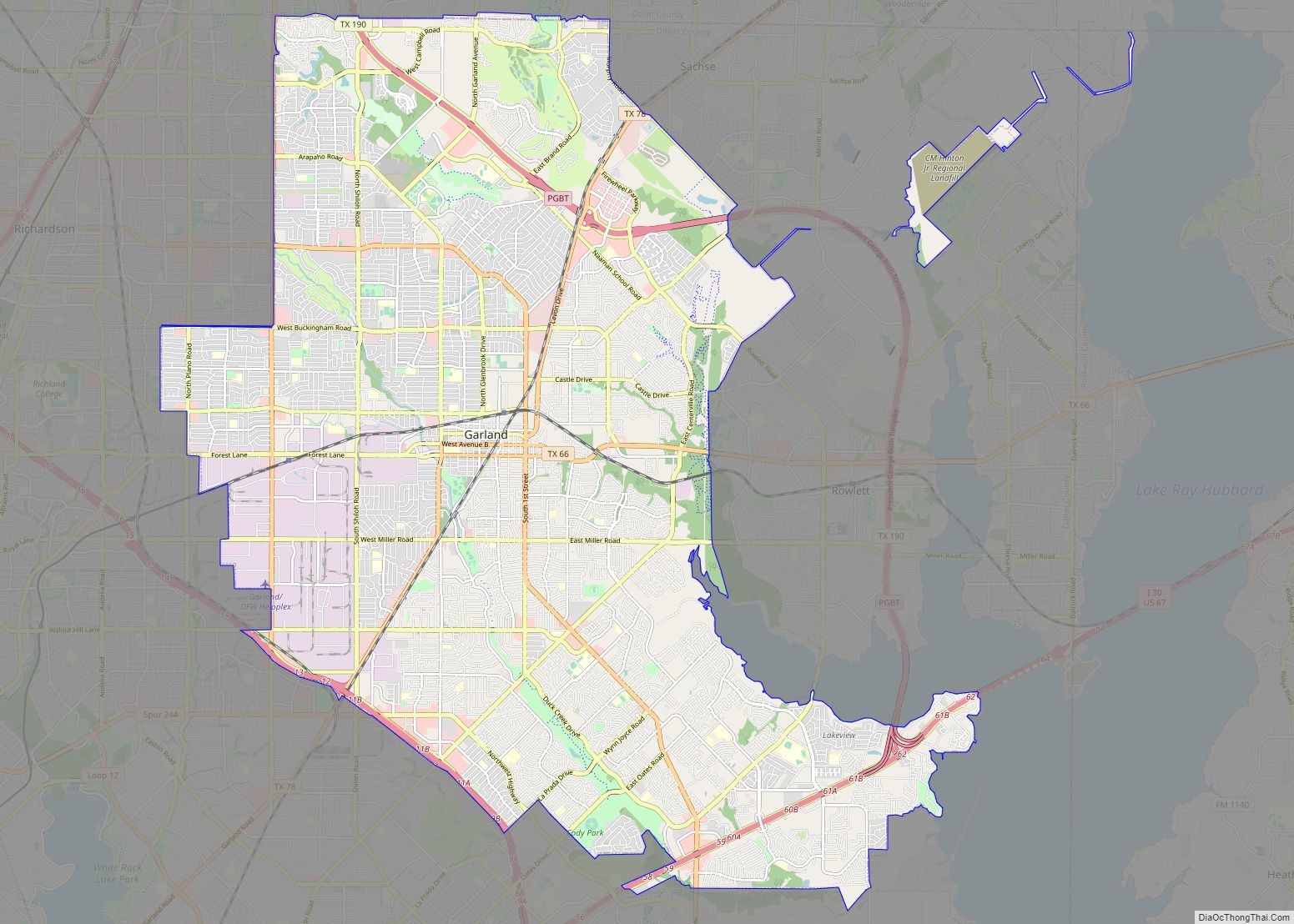
Garland is a city in the U.S. state of Texas. It is located northeast of Dallas and is a part of the Dallas–Fort Worth metroplex. It is located within Dallas County except for small portions located in Collin and Rockwall Counties. At the 2010 census, the city had a population of 226,876. In 2019, the … Read more

Map of Frisco city, Texas

Map of Frisco city, Texas

Frisco is a city in Collin and Denton counties in the U.S. state of Texas. It is part of the Dallas–Fort Worth metroplex and about 25 miles (40 km) from both Dallas Love Field and Dallas/Fort Worth International Airport. Its population was 200,509 in the 2020 U.S. census. Frisco was the fastest-growing city in the United … Read more

Map of McKinney city, Texas

Map of McKinney city, Texas

McKinney is a city in and the county seat of Collin County, Texas, United States. It is Collin County’s third-largest city, after Plano and Frisco. A suburb of the Dallas–Fort Worth metroplex, McKinney is about 32 miles (51 km) north of Dallas. The U.S. Census Bureau listed McKinney as the nation’s fastest-growing city from 2000 to … Read more

Map of Amarillo city

Map of Amarillo city

Amarillo (/ˌæməˈrɪloʊ/ AM-ə-RIL-oh; Spanish for “yellow”) is a city in the U.S. state of Texas and the seat of Potter County. It is the 14th-most populous city in Texas and the largest city in the Texas Panhandle. A portion of the city extends into Randall County. The estimated population of Amarillo was 200,393 as of … Read more

Map of Grand Prairie city

Map of Grand Prairie city

Grand Prairie is a city in Dallas, Tarrant, and Ellis counties of Texas, in the United States. It is part of the Mid-Cities region in the Dallas–Fort Worth metroplex. It had a population of 175,396 according to the 2010 census, making it the fifteenth most populous city in the state. Remaining the 15th-most populous city … Read more

Map of Brownsville city, Texas

Map of Brownsville city, Texas

Brownsville (/ˈbraʊnzˌvɪl/) is a city in and the county seat of Cameron County in the U.S. state of Texas. It is on the western Gulf Coast in South Texas, adjacent to the border with Matamoros, Mexico. The city covers 145.2 sq mi (376.066 km), and had a population of 186,738 at the 2020 census. It is the 139th-largest … Read more

Map of Killeen city

Map of Killeen city

Killeen is a city in Bell County, Texas, United States. According to the 2020 census, its population was 153,095, making it the 19th-most populous city in Texas and the largest of the three principal cities of Bell County. It is the principal city of the Killeen–Temple–Fort Hood Metropolitan Statistical Area. Killeen is 55 miles (89 km) … Read more

Map of Pasadena city, Texas

Map of Pasadena city, Texas

Pasadena (/ˌpæsəˈdiːnə/) is a city in the U.S. state of Texas, within the Houston–The Woodlands–Sugar Land metropolitan area. As of the 2020 U.S. census, the city’s population was 151,950, making it the twentieth most populous city in the state of Texas, as well as the second-largest city in Harris County. The area was founded in … Read more

Map of Denton city, Texas

Map of Denton city, Texas

Denton is a city in and the county seat of Denton County, Texas, United States. With a population of 139,869 as of 2020, it is the 27th-most populous city in Texas, the 197th-most populous city in the United States, and the 12th-most populous city in the Dallas–Fort Worth metroplex. A Texas land grant led to … Read more

Map of Mesquite CDP, Texas

Map of Mesquite CDP, Texas

Mesquite is a census-designated place (CDP) in Starr County, Texas, United States. It is a new CDP formed from part of the former Escobares CDP prior to the 2010 census with a population of 505. Mesquite CDP overview: Name: Mesquite CDP LSAD Code: 57 LSAD Description: CDP (suffix) State: Texas County: Starr County Total Area: … Read more

Map of McAllen city

Map of McAllen city

McAllen is the largest city in Hidalgo County, Texas, United States, and the 22nd-most populous city in Texas. It is located at the southern tip of the state in the Rio Grande Valley, on the Mexico–United States border. The city limits extend south to the Rio Grande, across from the Mexican city of Reynosa. McAllen … Read more

Map of Waco city, Texas

Map of Waco city, Texas

Waco (/ˈweɪkoʊ/ WAY-koh) is the county seat of McLennan County, Texas, United States. It is situated along the Brazos River and I-35, halfway between Dallas and Austin. The city had a 2020 population of 138,486, making it the 22nd-most populous city in the state. The 2021 U.S. Census population estimate for the city was 139,594. … Read more