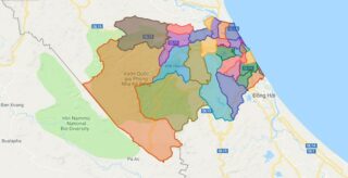
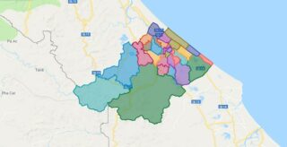
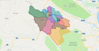
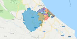
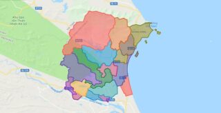
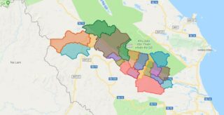
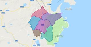
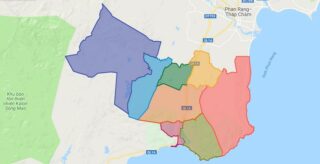
Political Map of Bo Trach district – Quang Binh Interactive online map of Bo Trach District. Source: Database of Global Administrative Areas, Global Map of Vietnam ©ISCGM, Ministry of Nutural Resources and Environment – Vietnam.Base Map Layer: Open Street Map (OSM), Arcgisonline, Google Map, Wmflabs. Large scale maps of Bo Trach District Bo Trach location ... Read more
Map of all districts of Vietnam
Political Map of Le Thuy district – Quang Binh Interactive online map of Le Thuy District. Source: Database of Global Administrative Areas, Global Map of Vietnam ©ISCGM, Ministry of Nutural Resources and Environment – Vietnam.Base Map Layer: Open Street Map (OSM), Arcgisonline, Google Map, Wmflabs. Large scale maps of Le Thuy District Le Thuy location ... Read more
Political Map of Minh Hoa district – Quang Binh Interactive online map of Minh Hoa District. Source: Database of Global Administrative Areas, Global Map of Vietnam ©ISCGM, Ministry of Nutural Resources and Environment – Vietnam.Base Map Layer: Open Street Map (OSM), Arcgisonline, Google Map, Wmflabs. Large scale maps of Minh Hoa District Minh Hoa location ... Read more
Political Map of Quang Ninh district – Quang Binh Interactive online map of Quang Ninh District. Source: Database of Global Administrative Areas, Global Map of Vietnam ©ISCGM, Ministry of Nutural Resources and Environment – Vietnam.Base Map Layer: Open Street Map (OSM), Arcgisonline, Google Map, Wmflabs. Large scale maps of Quang Ninh District Quang Ninh location ... Read more
Political Map of Quang Trach district – Quang Binh Interactive online map of Quang Trach District. Source: Database of Global Administrative Areas, Global Map of Vietnam ©ISCGM, Ministry of Nutural Resources and Environment – Vietnam.Base Map Layer: Open Street Map (OSM), Arcgisonline, Google Map, Wmflabs. Large scale maps of Quang Trach District Quang Trach location ... Read more
Political Map of Tuyen Hoa district – Quang Binh Interactive online map of Tuyen Hoa District. Source: Database of Global Administrative Areas, Global Map of Vietnam ©ISCGM, Ministry of Nutural Resources and Environment – Vietnam.Base Map Layer: Open Street Map (OSM), Arcgisonline, Google Map, Wmflabs. Large scale maps of Tuyen Hoa District Tuyen Hoa location ... Read more
Political Map of Thuan Bac district – Ninh Thuan Interactive online map of Thuan Bac District. Source: Database of Global Administrative Areas, Global Map of Vietnam ©ISCGM, Ministry of Nutural Resources and Environment – Vietnam.Base Map Layer: Open Street Map (OSM), Arcgisonline, Google Map, Wmflabs. Large scale maps of Thuan Bac District Thuan Bac location ... Read more
Political Map of Thuan Nam district – Ninh Thuan Interactive online map of Thuan Nam District. Source: Database of Global Administrative Areas, Global Map of Vietnam ©ISCGM, Ministry of Nutural Resources and Environment – Vietnam.Base Map Layer: Open Street Map (OSM), Arcgisonline, Google Map, Wmflabs. Large scale maps of Thuan Nam District Thuan Nam location ... Read more
Political Map of Viet Tri city – Phu Tho Interactive online map of Viet Tri City. Source: Database of Global Administrative Areas, Global Map of Vietnam ©ISCGM, Ministry of Nutural Resources and Environment – Vietnam.Base Map Layer: Open Street Map (OSM), Arcgisonline, Google Map, Wmflabs. Large scale maps of Viet Tri City Viet Tri location ... Read more
Political Map of Phu Tho town – Phu Tho Interactive online map of Phu Tho Town. Source: Database of Global Administrative Areas, Global Map of Vietnam ©ISCGM, Ministry of Nutural Resources and Environment – Vietnam.Base Map Layer: Open Street Map (OSM), Arcgisonline, Google Map, Wmflabs. Large scale maps of Phu Tho Town Phu Tho location ... Read more
Political Map of Cam Khe district – Phu Tho Interactive online map of Cam Khe District. Source: Database of Global Administrative Areas, Global Map of Vietnam ©ISCGM, Ministry of Nutural Resources and Environment – Vietnam.Base Map Layer: Open Street Map (OSM), Arcgisonline, Google Map, Wmflabs. Large scale maps of Cam Khe District Cam Khe location ... Read more
Political Map of Doan Hung district – Phu Tho Interactive online map of Doan Hung District. Source: Database of Global Administrative Areas, Global Map of Vietnam ©ISCGM, Ministry of Nutural Resources and Environment – Vietnam.Base Map Layer: Open Street Map (OSM), Arcgisonline, Google Map, Wmflabs. Large scale maps of Doan Hung District Doan Hung location ... Read more