Aurora is a city in the Chicago metropolitan area. Located primarily in DuPage and Kane Counties, it is the second most populous city in Illinois, after Chicago, and the 144th most populous city in the United States. The population was 197,899 at the 2010 census, and was 180,542 at the 2020 census.
Founded within Kane County, Aurora’s city limits have expanded into DuPage, Kendall, and Will counties. Once a mid-sized manufacturing city, Aurora has grown since the 1960s. From 2000 to 2009, the U.S. Census Bureau ranked the city as the 46th fastest growing city with a population of over 100,000.
In 1908, Aurora adopted the nickname “City of Lights”, because in 1881 it was one of the first cities in the United States to implement an all-electric street lighting system. Aurora’s historic downtown is located on the Fox River, and centered on Stolp Island. The city is divided into three regions, the West Side, on the west side of the Fox River, the East Side, between the eastern bank of the Fox River and the Kane/DuPage County line, and the Far East Side/Fox Valley, which is from the County Line to the city’s eastern border with Naperville.
The Aurora area has some significant architecture, including structures by Frank Lloyd Wright, Ludwig Mies van der Rohe, Bruce Goff and George Grant Elmslie. Aurora is also home to over 50 Sears Catalog Homes and seven Lustron all-steel homes. The Hollywood Casino Aurora, a dockside gaming facility with 53,000 square feet (4,900 m) and 1,200 gaming positions, is located along the river in downtown Aurora.
| Name: | Aurora city |
|---|---|
| LSAD Code: | 25 |
| LSAD Description: | city (suffix) |
| State: | Illinois |
| County: | DuPage County, Kane County, Kendall County, Will County |
| Elevation: | 719 ft (219 m) |
| Total Area: | 45.91 sq mi (118.91 km²) |
| Land Area: | 44.97 sq mi (116.47 km²) |
| Water Area: | 0.94 sq mi (2.45 km²) |
| Total Population: | 180,542 |
| Population Density: | 4,014.81/sq mi (1,550.13/km²) |
| FIPS code: | 1703012 |
| GNISfeature ID: | 2394031 |
| Website: | www.aurora-il.org |
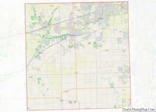
Online Interactive Map
Click on ![]() to view map in "full screen" mode.
to view map in "full screen" mode.
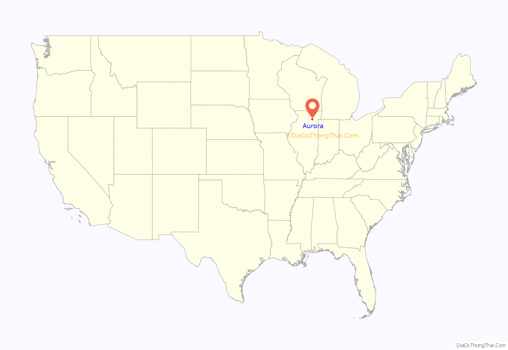
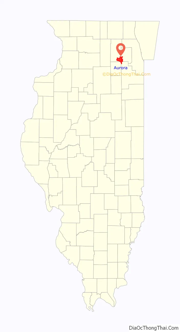
Aurora location map. Where is Aurora city?
History
Before European settlers arrived, there was a Native American village in what is today downtown Aurora, on the banks of the Fox River. In 1834, following the Black Hawk War, the McCarty brothers settled on both sides of the river, but subsequently sold their land on the west side to the Lake brothers, who opened a mill. The McCartys lived on and operated a mill on the east side. Aurora was established with the building of a post office in 1837.
Aurora began as two villages: East Aurora, incorporated in 1845 on the east side of the river, and West Aurora, formally organized on the west side of the river in 1854. In 1857, the two towns joined, incorporating as the city of Aurora. Representatives could not agree which side of the river should house the public buildings, so most of them were built on or around Stolp Island in the middle of the river.
As the city grew, it attracted numerous factories and jobs. In 1849, after failing to attract the Galena and Chicago Union Railroad building west from Chicago, the Aurora Branch Railroad was chartered to build a connection from Aurora to the G&CU at a place called Turner Junction, now West Chicago. Additional lines were built, including a direct line to Chicago, and in 1855 the company was reorganized into the Chicago, Burlington and Quincy Railroad. The CB&Q located its roundhouse and locomotive shop in Aurora, becoming the town’s largest employer until the 1960s. Restructuring in the railroad industry resulted in a loss of jobs as passenger traffic dropped and the number of railroads decreased. The Burlington Railroad ran regularly scheduled passenger trains to Chicago. Other railroads built lines to Aurora, including the Chicago & Northwestern Railway to Geneva, the Elgin, Joliet and Eastern Railway to Joliet, Chicago, Milwaukee & Gary to Rockford, and the interurbans Chicago Aurora and Elgin Railroad, Aurora, Elgin and Fox River Electric Company, Chicago, Aurora and DeKalb Railroad, and Aurora, Plainfield and Joliet Railroad. With the exception of the EJ&E main line on the east side of the city, all lines other than the former Burlington lines have been abandoned.
The heavy industries on the East side provided employment for generations of European immigrants, who came from Ireland, Great Britain, Scandinavia, Luxembourg, Germany, France, Romania and Italy. Aurora became the economic center of the Fox Valley region. The combination of these three factors—a highly industrialized town, a sizable river that divided it, and the Burlington railroad’s shops—accounted for much of the dynamics of Aurora’s political, economic, and social history. The city openly supported abolitionism before the American Civil War. Mexican migrants began arriving after the Mexican Revolution of 1910. Socially, the town was progressive in its attitude toward education, religion, welfare, and women. The first free public school district in Illinois was established in 1851 here and the city established a high school for girls in 1855.
The city developed as a manufacturing powerhouse which lasted until the early 1970s, when the railroad shops closed. Many other factories and industrial areas relocated or went out of business. By 1980, there were few industrial areas operating in the city, and unemployment soared to 16%. During the late 1970s and early 1980s, development began in the Far East side along the Eola Road and Route 59 areas. This was financially beneficial to the city, but it sapped retail businesses downtown and manufacturing in the industrial sectors of the near East and West Sides, weakening them. In the mid-1980s crime rates soared and street gangs formed.
During this time Aurora became much more ethnically diverse. The Latino population grew rapidly in the city during the 1980s. In the late 1980s, several business and industrial parks were established on the city’s outskirts. In 1993, the Hollywood Casino was built downtown, which helped bring the first redevelopment to the downtown area in nearly twenty years. In the late 1990s, more development began in the rural areas and towns outside Aurora. Subdivisions sprouted up around the city, and Aurora’s population soared.
Today, Aurora is an ethnically diverse city of nearly 200,000 residents. Historic areas downtown are being redeveloped, and new developments are being built across the city.
Aurora Road Map
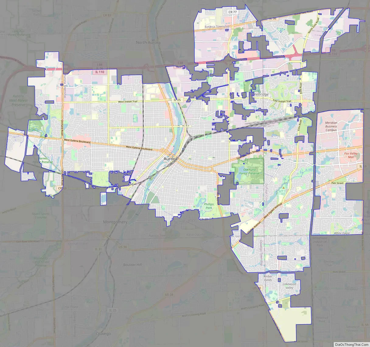
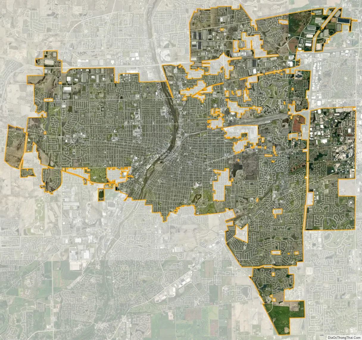
Aurora city Satellite Map
Geography
Aurora is at 41°45′50″N 88°17′24″W / 41.76389°N 88.29000°W / 41.76389; -88.29000 (41.7637855, −88.2901352).
According to the 2021 census gazetteer files, Aurora has a total area of 45.91 square miles (118.91 km), of which 44.97 square miles (116.47 km) (or 97.94%) is land and 0.94 square miles (2.43 km) (or 2.06%) is water.
While the city has traditionally been regarded as being in Kane County, Aurora also includes parts of DuPage, Kendall and Will counties. Aurora is one of only three cities in Illinois that span four counties. (The others are Barrington Hills and Centralia.)
Regions of Aurora
Politically, the city is divided into 10 wards. Large portions of Aurora can be described as being within three regions:
- The West Side, which is west of the Fox River.
- The East Side, which spans the region east of the Fox River, stopping at the DuPage County line.
- The Far East Side, a portion of Aurora east of the DuPage County line
These three regions are partly depicted in police boundaries and school districts.
Climate
The annual precipitation for Aurora is about 40 inches. The record high for Aurora is 111 °F (44 °C), on July 14, 1936. The record low is −31 °F (−35 °C), on January 16, 2009. The average high temperature for Aurora in July is 83.5 °F (28.6 °C), the average January low is 12.6 °F (−10.8 °C).
On July 17–18, 1996, a major flood struck Aurora, with 16.9 inches (430 mm) of rain in a 24-hour period, which is an Illinois state record, and the second highest ever nationally. Flooding occurred in almost every low-lying area in the city, and in neighborhoods bordering the Fox River, causing major damage in some neighborhoods. The flooding was just as bad in Blackberry Creek, on Aurora’s far west side.
Aurora has not been struck by any major tornadoes in recent history, although they occur in Northern Illinois annually. In 1906, a tornado went through the Aurora Driving Park, a large recreation/amusement park and race track where the Riddle Highlands neighborhood and Northgate shopping center is today. The tornado hit during the afternoon performance of the Ringling Brothers “Greatest Show on Earth” circus, when the park was crowded. It killed 2 people and injured 22, but the grandstand was still filled for the evening performance. Weak tornadoes struck the city in 1954, 1958, 1960, and 1991. In 1990, the supercell thunderstorm that produced the deadly Plainfield Tornado passed over the city, dropping golf ball sized hail and causing wind damage. Less than ten minutes after passing through Aurora, the storm produced an F5 tornado, which touched down in nearby Oswego, less than 5 miles from downtown. The tornado then traveled through Plainfield and Joliet, killing 29 people.
The city can receive heavy snowfall and experiences blizzards periodically.
Aurora was hit with one of the strongest earthquakes ever to strike Illinois, a M 5.1, on May 26, 1909. It put cracks through chimneys and could be felt 500,000 sq mi (1,300,000 km) around.
See also
Map of Illinois State and its subdivision:- Adams
- Alexander
- Bond
- Boone
- Brown
- Bureau
- Calhoun
- Carroll
- Cass
- Champaign
- Christian
- Clark
- Clay
- Clinton
- Coles
- Cook
- Crawford
- Cumberland
- De Kalb
- De Witt
- Douglas
- Dupage
- Edgar
- Edwards
- Effingham
- Fayette
- Ford
- Franklin
- Fulton
- Gallatin
- Greene
- Grundy
- Hamilton
- Hancock
- Hardin
- Henderson
- Henry
- Iroquois
- Jackson
- Jasper
- Jefferson
- Jersey
- Jo Daviess
- Johnson
- Kane
- Kankakee
- Kendall
- Knox
- La Salle
- Lake
- Lake Michigan
- Lawrence
- Lee
- Livingston
- Logan
- Macon
- Macoupin
- Madison
- Marion
- Marshall
- Mason
- Massac
- McDonough
- McHenry
- McLean
- Menard
- Mercer
- Monroe
- Montgomery
- Morgan
- Moultrie
- Ogle
- Peoria
- Perry
- Piatt
- Pike
- Pope
- Pulaski
- Putnam
- Randolph
- Richland
- Rock Island
- Saint Clair
- Saline
- Sangamon
- Schuyler
- Scott
- Shelby
- Stark
- Stephenson
- Tazewell
- Union
- Vermilion
- Wabash
- Warren
- Washington
- Wayne
- White
- Whiteside
- Will
- Williamson
- Winnebago
- Woodford
- Alabama
- Alaska
- Arizona
- Arkansas
- California
- Colorado
- Connecticut
- Delaware
- District of Columbia
- Florida
- Georgia
- Hawaii
- Idaho
- Illinois
- Indiana
- Iowa
- Kansas
- Kentucky
- Louisiana
- Maine
- Maryland
- Massachusetts
- Michigan
- Minnesota
- Mississippi
- Missouri
- Montana
- Nebraska
- Nevada
- New Hampshire
- New Jersey
- New Mexico
- New York
- North Carolina
- North Dakota
- Ohio
- Oklahoma
- Oregon
- Pennsylvania
- Rhode Island
- South Carolina
- South Dakota
- Tennessee
- Texas
- Utah
- Vermont
- Virginia
- Washington
- West Virginia
- Wisconsin
- Wyoming