| Name: | Chicago city |
|---|---|
| LSAD Code: | 25 |
| LSAD Description: | city (suffix) |
| State: | Illinois |
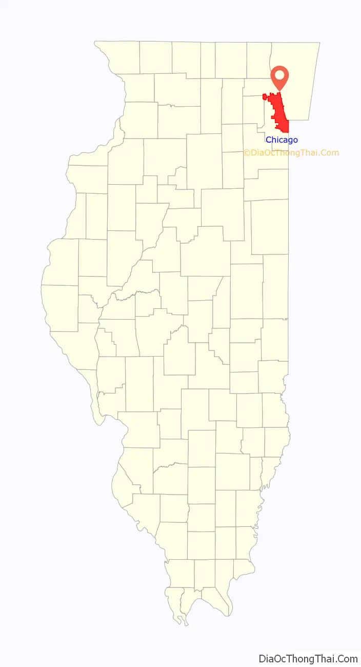
| County: | Cook County, DuPage County |
| Land Area: | 227.73 sq mi (589.82 km²) |
| Water Area: | 6.80 sq mi (17.62 km²) |
| Population Density: | 12,059.84/sq mi (4,656.33/km²) |
| FIPS code: | 1714000 |
| GNISfeature ID: | 0428803 |
| Website: | chicago.gov |
Your Ultimate Chicago Map Collection:
1. Road Map of Chicago – Get around the city quickly and easily with this detailed road map of Chicago.
2. Chicago Area Map – See the major highways and cities in the Chicago area.
3. Interactive Map of Chicago – Zoom in and out to view the city with ease.
4. Chicago Landmarks Map – Tourist sites, parks, and attractions of the Windy City.
Your Ultimate Chicago Map Collection
Discover Chicago with this ultimate map collection for the Windy City. It includes a road map, a map of the Chicago area, and an interactive map to view the city with ease. You’ll also find a Chicago landmarks map featuring tourist sites like Millennium Park, Willis Tower, the Art Institute of Chicago, and Navy Pier along Lake Michigan.
Chicago has so much to offer that you need to see. It’s a world-renowned center of commerce, finance, and art, and home to America’s third-largest metropolitan area. Get around quickly and easily with the detailed road map of Chicago, or view the major highways and cities in the Chicago area. Zoom in and out to view the city with ease on the interactive map of Chicago, and explore tourist sites, parks, and attractions of the Windy City on the Chicago landmarks map.
Online Interactive Map
Click on ![]() to view map in "full screen" mode.
to view map in "full screen" mode.
This map has a lot of useful information such as public transportation and directions to local attractions. From restaurants to hotels, to sports venues, this interactive map of Chicago will make sure you have everything you need. Whether you’re traveling, looking for the perfect souvenir, or planning a big event, find Chicago’s best attractions and restaurants with this interactive map.
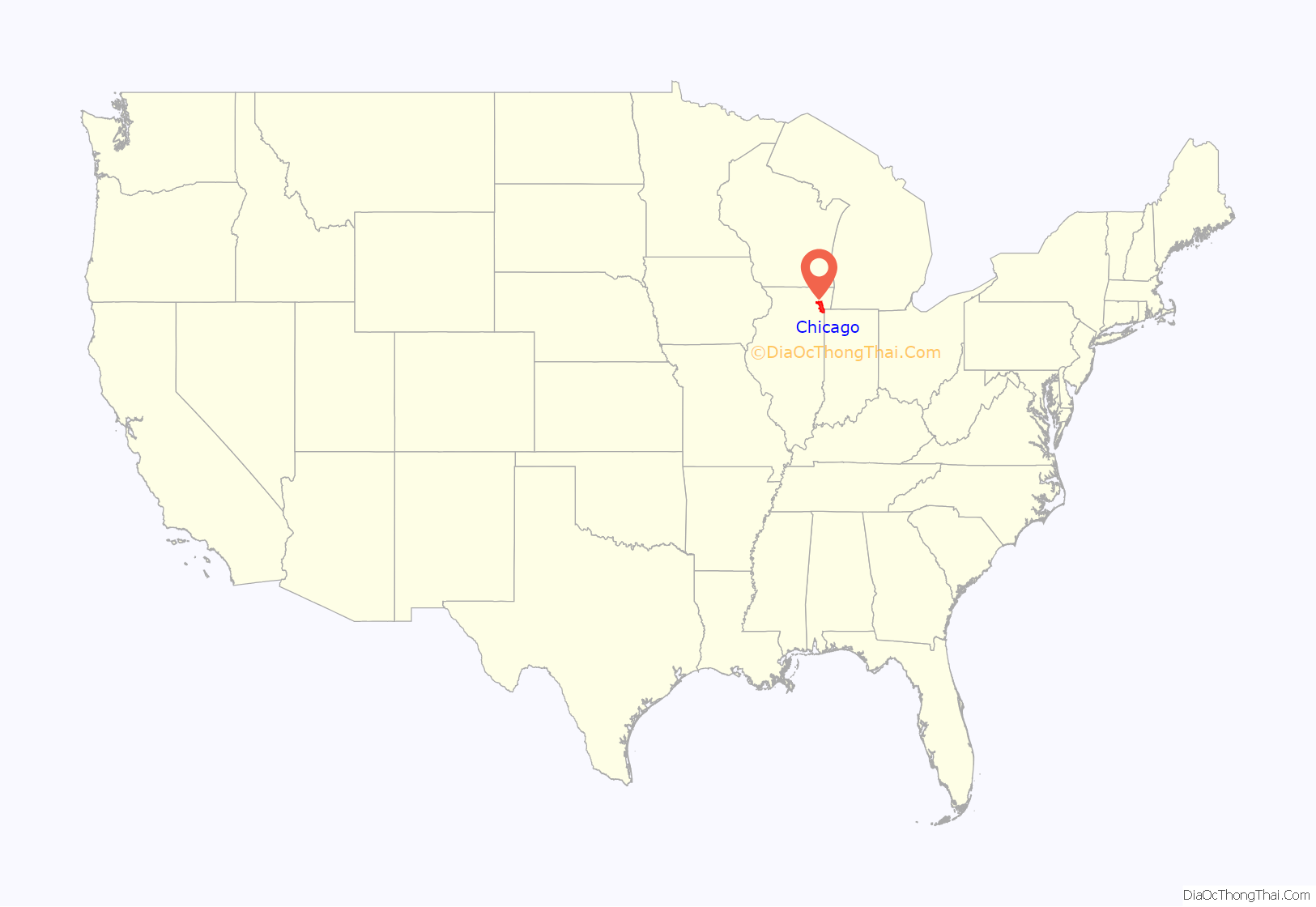
Chicago location map. Where is Chicago city?
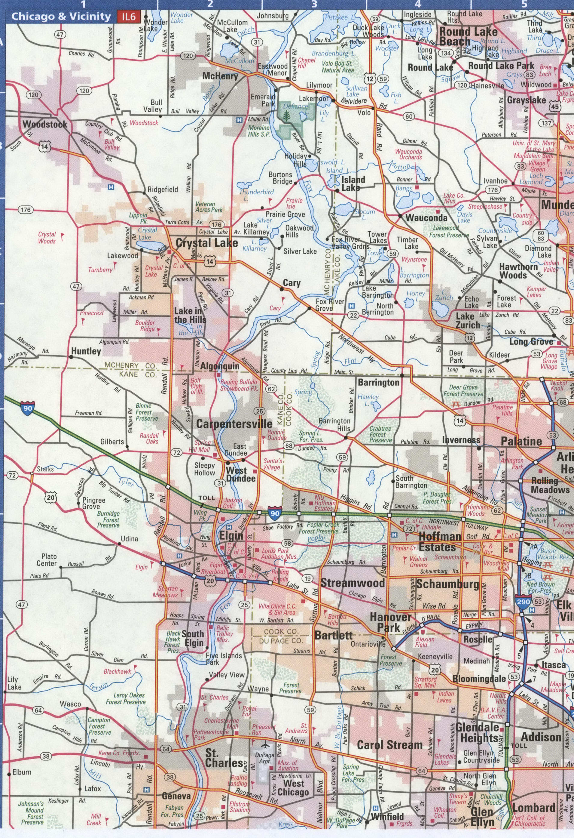
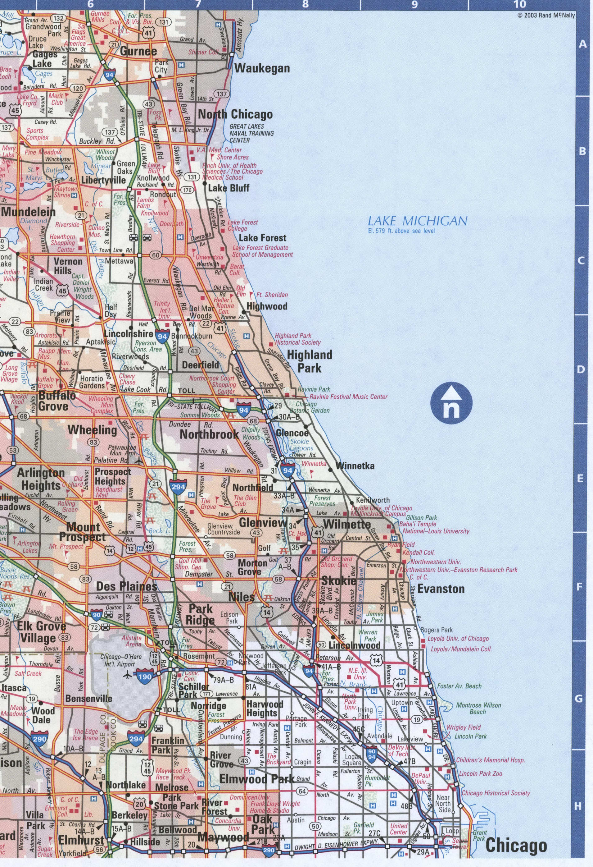
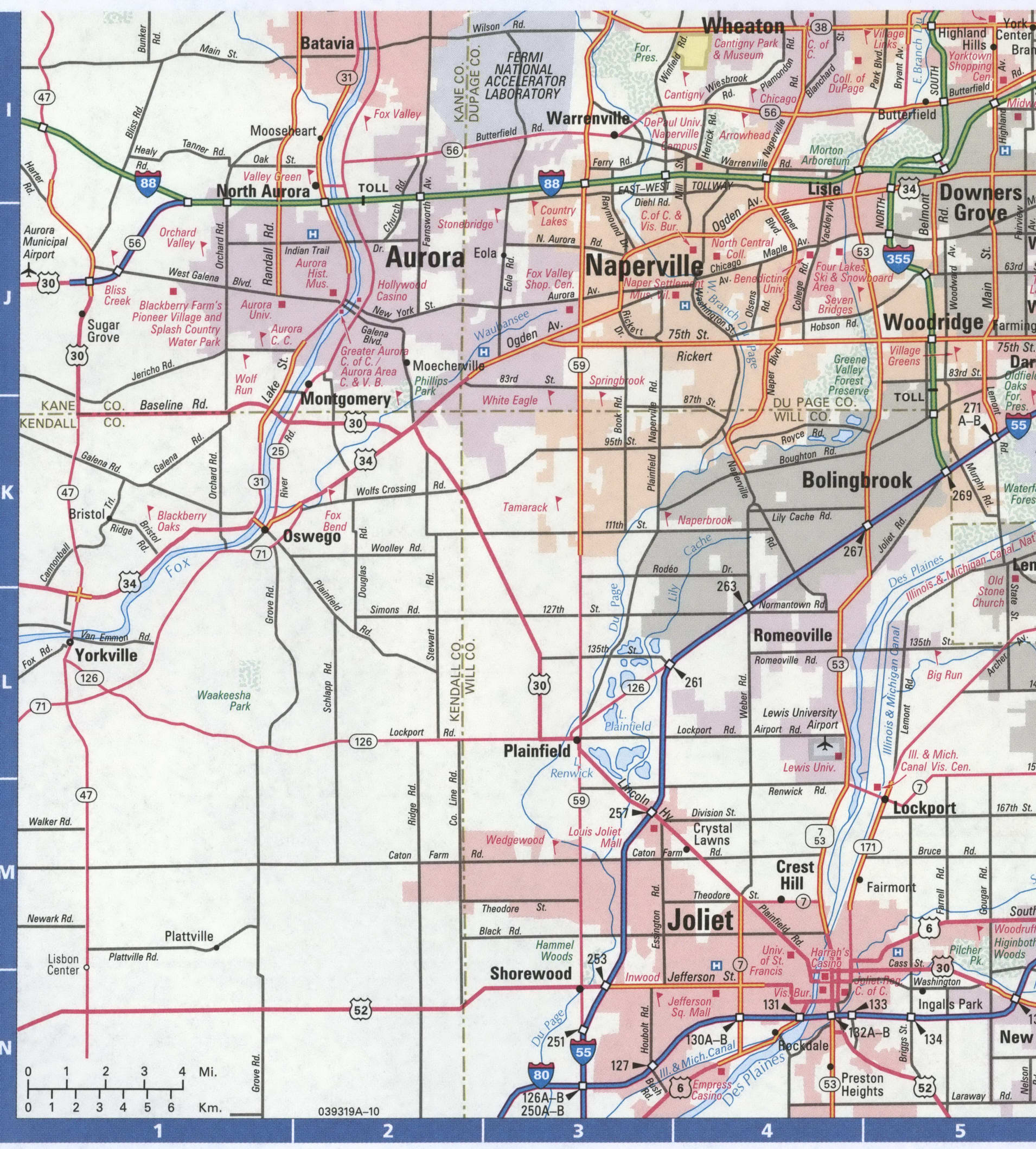
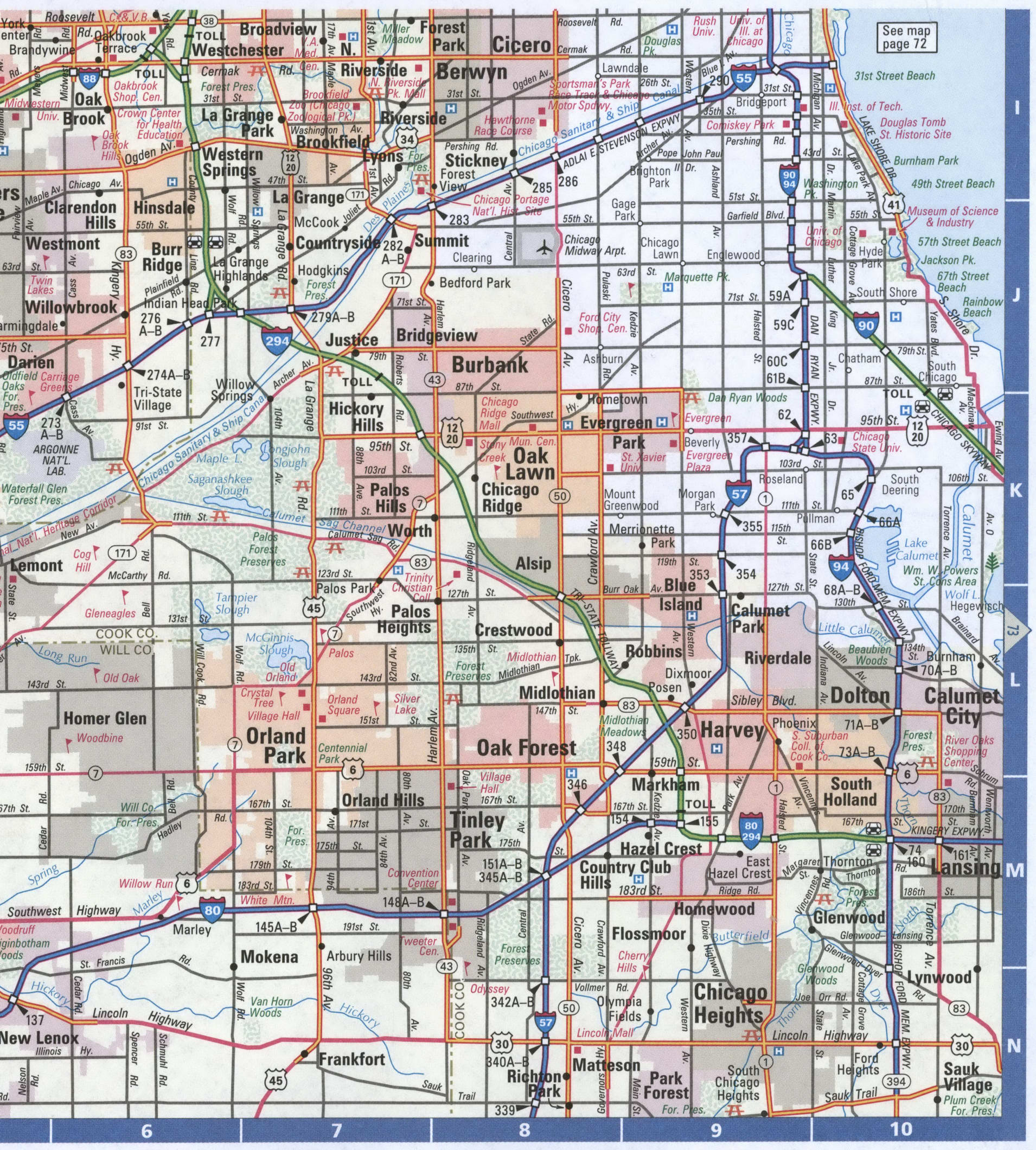
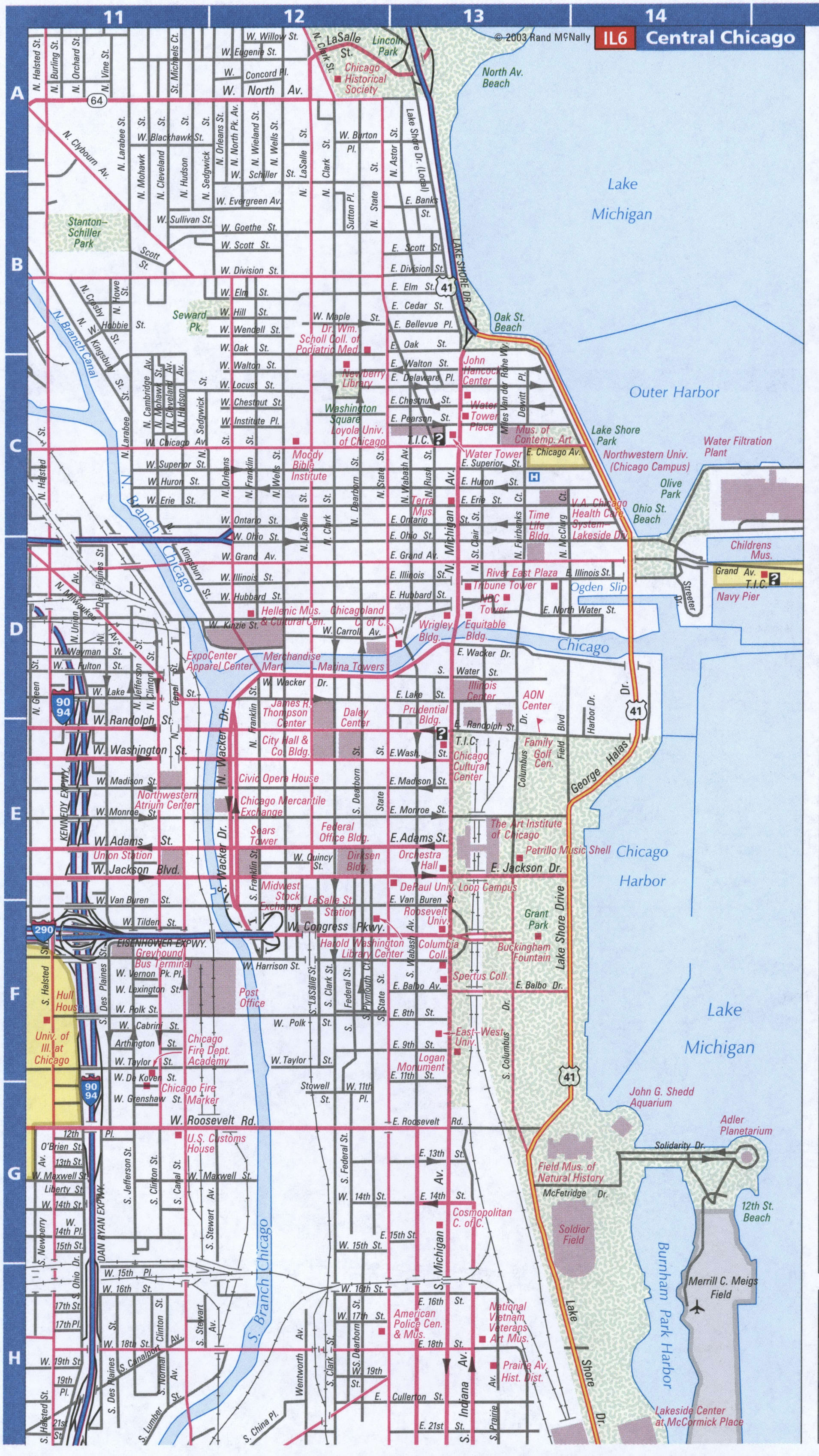
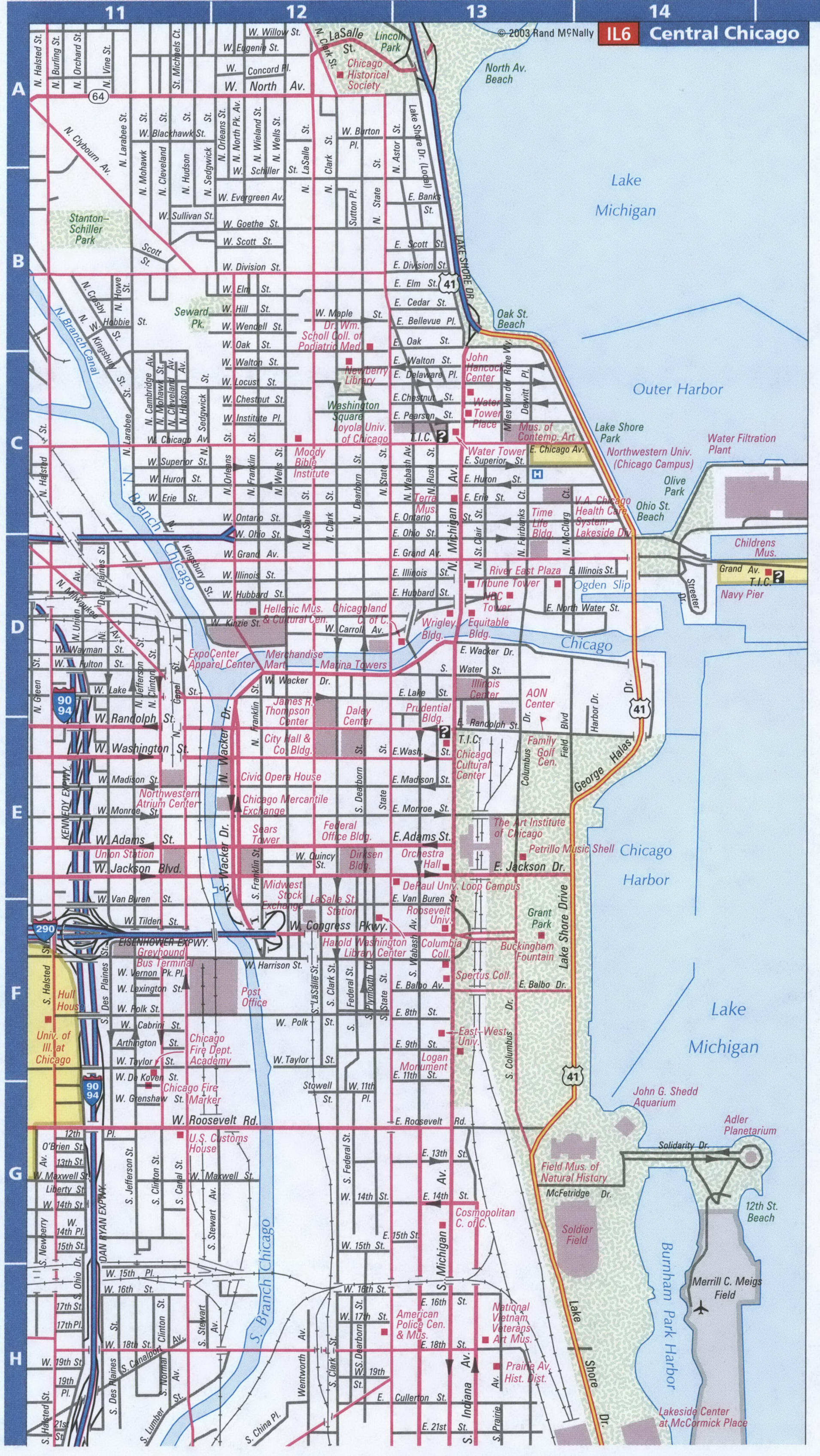
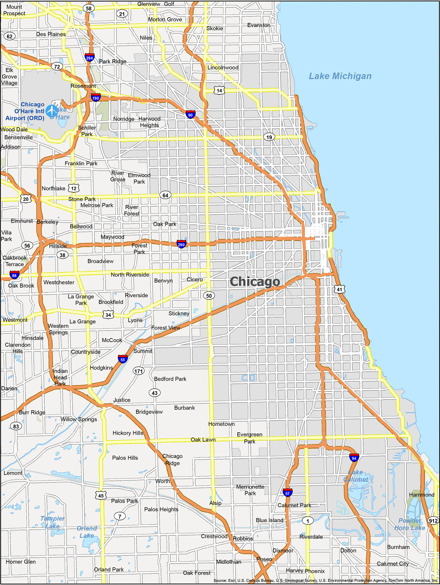
Chicago Road Map
Get the most out of your travels by using this printable map to find the most convenient ways to navigate your way around in one of the most iconic cities in America – Chicago. Whether it’s your first time visiting, or you’re looking for a new adventure, our free Chicago road map can help you plan your day and make the most of your time. It shows interstates, highways, and major roads of the city. If you are looking for a place to visit and also want to experience a little culture, then this map is the perfect way to get you there. Or explore outside the city with the Illinois road map.
Interstate Highways: I-55, I-57, I-90, I-94, I-190, I-290, I-294
US Highways: 12, 19, 14, 41, 43, 50, 55, 57, 64, 90, 94, 190, 290,
Parkways/Expressways: Congress Pky, Kennedy Expy,
Major Roads: 63rd St, 71st St, 85th St, 87th St, 95th St, Baker Ave, Bond Ave, Broadway St, Burley Ave, Chicago Ohare Intl Arpt, Cicero Ave, Coast Guard Dr, Ewing Ave, Foster Ave, Harlem Ave, Hayes Dr, Hollywood Ave, Indianapolis Ave, Irving Park Rd, La Salle Dr, Lake Shore Dr, Mackinaw Ave, Michigan Ave, North Ave, Ohio St, Ontario St, Peterson Ave, Pulaski Rd, Ridge Ave, Roosevelt Rd, South Shore Dr, Stony Island Ave
Chicago is a city of unique neighborhoods, each with its own unique vibe, history, and identity. Whether you’re looking for a walkable area, a bustling downtown, or a scenic lookout, there’s a neighborhood in the Windy City to suit your needs. Our reference map of Chicago is the perfect tool to help you explore the city and find the many things to see and do. From Berwyn to Cicero, and from Addison to Worth, discover all the towns, cities and villages that make up this great city.
10 things to do in Chicago city
From iconic attractions to unique restaurants, Chicago is a city full of opportunities to explore. Whether you’re looking for a family-friendly trip or a romantic getaway, this map of Chicago will help you plan your perfect vacation.
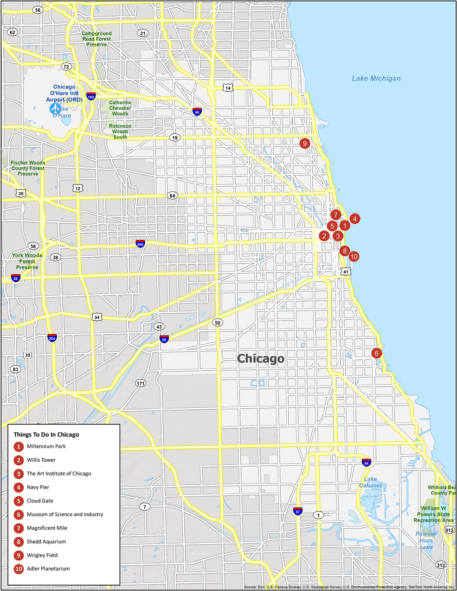
Chicago is a great destination for travelers looking to explore new places. With its iconic attractions, world-class museums, and delicious restaurants, there’s something for everyone. This map provides a list of recommendations for your trip to Chicago. From Millennium Park to Wrigley Field, you’ll find plenty of fun places to explore in the Windy City.
From family-friendly activities to romantic getaways, this map of Chicago will help you plan your perfect vacation. Check out our list of recommendations for the best places to visit in the city, including Millennium Park, the Art Institute of Chicago, Navy Pier, Cloud Gate, the Museum of Science and Industry, the Magnificent Mile, Shedd Aquarium, Wrigley Field, and the Adler Planetarium. Make sure to include these destinations on your trip to Chicago – you won’t be disappointed!
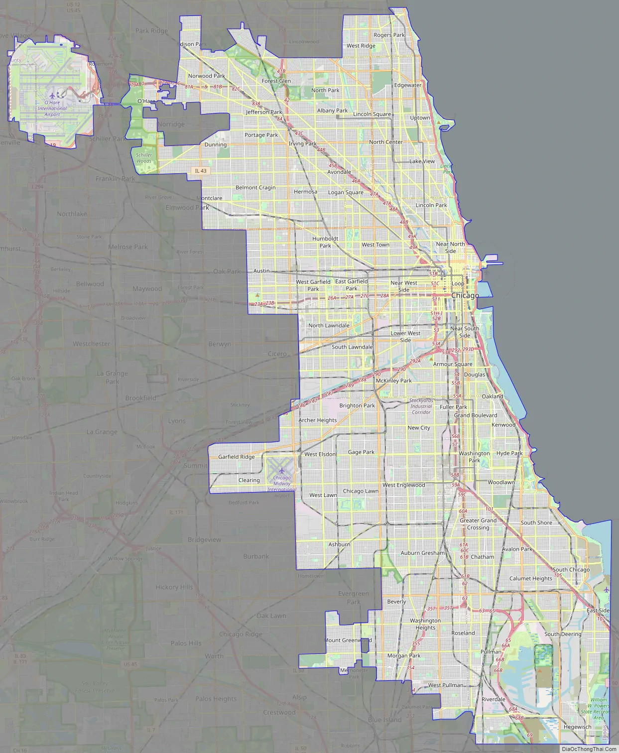
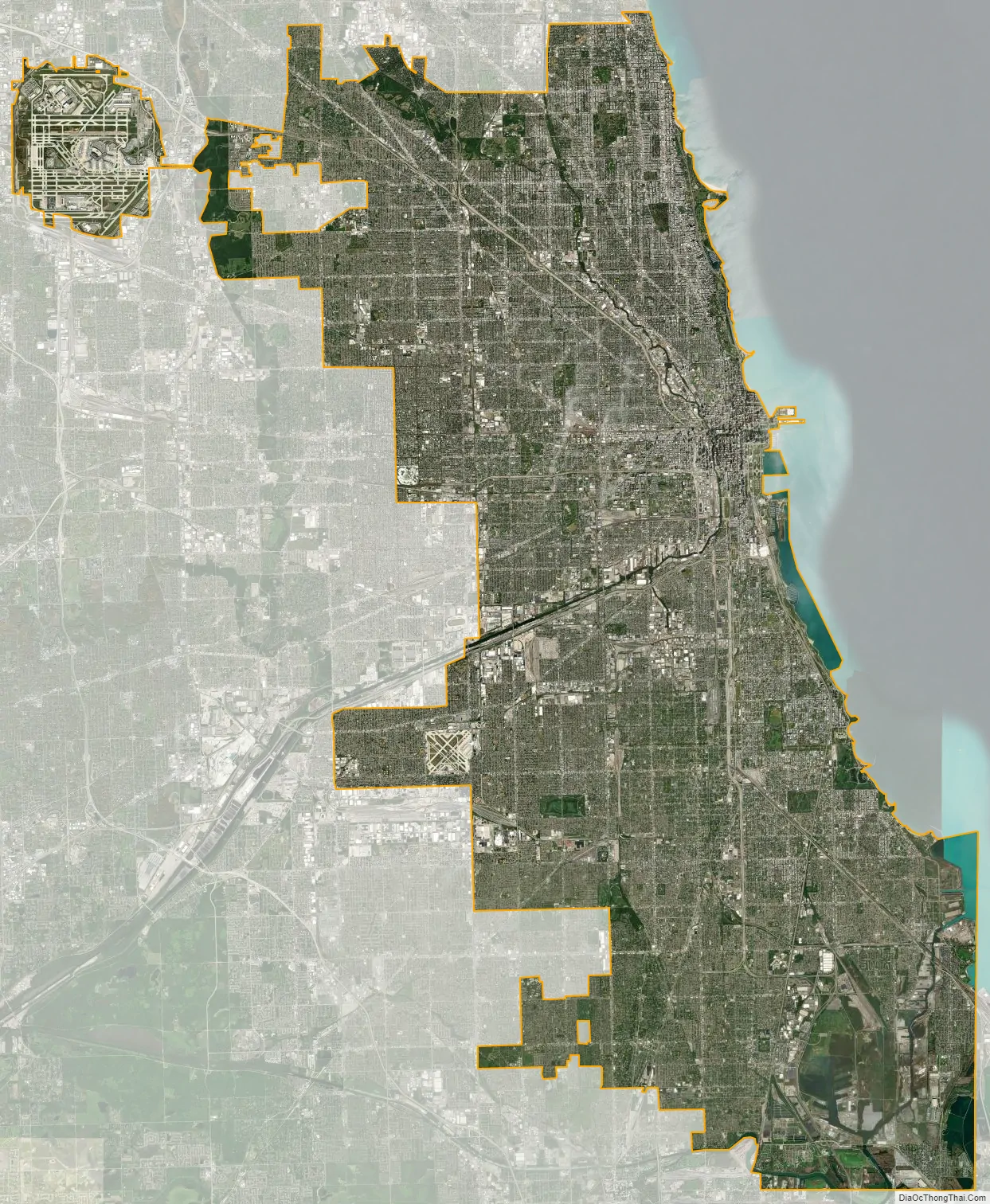
Chicago city Satellite Map
Geography
Topography
Chicago is located in northeastern Illinois on the southwestern shores of freshwater Lake Michigan. It is the principal city in the Chicago metropolitan area, situated in both the Midwestern United States and the Great Lakes region. The city rests on a continental divide at the site of the Chicago Portage, connecting the Mississippi River and the Great Lakes watersheds. In addition to it lying beside Lake Michigan, two rivers—the Chicago River in downtown and the Calumet River in the industrial far South Side—flow either entirely or partially through the city.
Chicago’s history and economy are closely tied to its proximity to Lake Michigan. While the Chicago River historically handled much of the region’s waterborne cargo, today’s huge lake freighters use the city’s Lake Calumet Harbor on the South Side. The lake also provides another positive effect: moderating Chicago’s climate, making waterfront neighborhoods slightly warmer in winter and cooler in summer.
When Chicago was founded in 1837, most of the early building was around the mouth of the Chicago River, as can be seen on a map of the city’s original 58 blocks. The overall grade of the city’s central, built-up areas is relatively consistent with the natural flatness of its overall natural geography, generally exhibiting only slight differentiation otherwise. The average land elevation is 579 ft (176.5 m) above sea level. While measurements vary somewhat, the lowest points are along the lake shore at 578 ft (176.2 m), while the highest point, at 672 ft (205 m), is the morainal ridge of Blue Island in the city’s far south side.
While the Chicago Loop is the central business district, Chicago is also a city of neighborhoods. Lake Shore Drive runs adjacent to a large portion of Chicago’s waterfront. Some of the parks along the waterfront include Lincoln Park, Grant Park, Burnham Park, and Jackson Park. There are 24 public beaches across 26 miles (42 km) of the waterfront. Landfill extends into portions of the lake providing space for Navy Pier, Northerly Island, the Museum Campus, and large portions of the McCormick Place Convention Center. Most of the city’s high-rise commercial and residential buildings are close to the waterfront.
An informal name for the entire Chicago metropolitan area is “Chicagoland”, which generally means the city and all its suburbs. The Chicago Tribune, which coined the term, includes the city of Chicago, the rest of Cook County, and eight nearby Illinois counties: Lake, McHenry, DuPage, Kane, Kendall, Grundy, Will and Kankakee, and three counties in Indiana: Lake, Porter and LaPorte. The Illinois Department of Tourism defines Chicagoland as Cook County without the city of Chicago, and only Lake, DuPage, Kane, and Will counties. The Chicagoland Chamber of Commerce defines it as all of Cook and DuPage, Kane, Lake, McHenry, and Will counties.
Communities
Major sections of the city include the central business district, called The Loop, and the North, South, and West Sides. The three sides of the city are represented on the Flag of Chicago by three horizontal white stripes. The North Side is the most-densely-populated residential section of the city, and many high-rises are located on this side of the city along the lakefront. The South Side is the largest section of the city, encompassing roughly 60% of the city’s land area. The South Side contains most of the facilities of the Port of Chicago.
In the late-1920s, sociologists at the University of Chicago subdivided the city into 77 distinct community areas, which can further be subdivided into over 200 informally defined neighborhoods.
Streetscape
Chicago’s streets were laid out in a street grid that grew from the city’s original townsite plot, which was bounded by Lake Michigan on the east, North Avenue on the north, Wood Street on the west, and 22nd Street on the south. Streets following the Public Land Survey System section lines later became arterial streets in outlying sections. As new additions to the city were platted, city ordinance required them to be laid out with eight streets to the mile in one direction and sixteen in the other direction, about one street per 200 meters in one direction and one street per 100 meters in the other direction. The grid’s regularity provided an efficient means of developing new real estate property. A scattering of diagonal streets, many of them originally Native American trails, also cross the city (Elston, Milwaukee, Ogden, Lincoln, etc.). Many additional diagonal streets were recommended in the Plan of Chicago, but only the extension of Ogden Avenue was ever constructed.
In 2016, Chicago was ranked the sixth-most walkable large city in the United States. Many of the city’s residential streets have a wide patch of grass or trees between the street and the sidewalk itself. This helps to keep pedestrians on the sidewalk further away from the street traffic. Chicago’s Western Avenue is the longest continuous urban street in the world. Other notable streets include Michigan Avenue, State Street, Oak, Rush, Clark Street, and Belmont Avenue. The City Beautiful movement inspired Chicago’s boulevards and parkways.
Architecture
The destruction caused by the Great Chicago Fire led to the largest building boom in the history of the nation. In 1885, the first steel-framed high-rise building, the Home Insurance Building, rose in the city as Chicago ushered in the skyscraper era, which would then be followed by many other cities around the world. Today, Chicago’s skyline is among the world’s tallest and densest.
Some of the United States’ tallest towers are located in Chicago; Willis Tower (formerly Sears Tower) is the second tallest building in the Western Hemisphere after One World Trade Center, and Trump International Hotel and Tower is the third tallest in the country. The Loop’s historic buildings include the Chicago Board of Trade Building, the Fine Arts Building, 35 East Wacker, and the Chicago Building, 860-880 Lake Shore Drive Apartments by Mies van der Rohe. Many other architects have left their impression on the Chicago skyline such as Daniel Burnham, Louis Sullivan, Charles B. Atwood, John Root, and Helmut Jahn.
The Merchandise Mart, once first on the list of largest buildings in the world, currently listed as 44th-largest (as of 9 September 2013), had its own zip code until 2008, and stands near the junction of the North and South branches of the Chicago River. Presently, the four tallest buildings in the city are Willis Tower (formerly the Sears Tower, also a building with its own zip code), Trump International Hotel and Tower, the Aon Center (previously the Standard Oil Building), and the John Hancock Center. Industrial districts, such as some areas on the South Side, the areas along the Chicago Sanitary and Ship Canal, and the Northwest Indiana area are clustered.
Chicago gave its name to the Chicago School and was home to the Prairie School, two movements in architecture. Multiple kinds and scales of houses, townhouses, condominiums, and apartment buildings can be found throughout Chicago. Large swaths of the city’s residential areas away from the lake are characterized by brick bungalows built from the early 20th century through the end of World War II. Chicago is also a prominent center of the Polish Cathedral style of church architecture. The Chicago suburb of Oak Park was home to famous architect Frank Lloyd Wright, who had designed The Robie House located near the University of Chicago.
A popular tourist activity is to take an architecture boat tour along the Chicago River.
Monuments and public art
Chicago is famous for its outdoor public art with donors establishing funding for such art as far back as Benjamin Ferguson’s 1905 trust. A number of Chicago’s public art works are by modern figurative artists. Among these are Chagall’s Four Seasons; the Chicago Picasso; Miro’s Chicago; Calder’s Flamingo; Oldenburg’s Batcolumn; Moore’s Large Interior Form, 1953-54, Man Enters the Cosmos and Nuclear Energy; Dubuffet’s Monument with Standing Beast, Abakanowicz’s Agora; and, Anish Kapoor’s Cloud Gate which has become an icon of the city. Some events which shaped the city’s history have also been memorialized by art works, including the Great Northern Migration (Saar) and the centennial of statehood for Illinois. Finally, two fountains near the Loop also function as monumental works of art: Plensa’s Crown Fountain as well as Burnham and Bennett’s Buckingham Fountain.
More representational and portrait statuary includes a number of works by Lorado Taft (Fountain of Time, The Crusader, Eternal Silence, and the Heald Square Monument completed by Crunelle), French’s Statue of the Republic, Edward Kemys’s Lions, Saint-Gaudens’s Abraham Lincoln: The Man (a.k.a. Standing Lincoln) and Abraham Lincoln: The Head of State (a.k.a. Seated Lincoln), Brioschi’s Christopher Columbus, Meštrović’s The Bowman and The Spearman, Dallin’s Signal of Peace, Fairbanks’s The Chicago Lincoln, Boyle’s The Alarm, Polasek’s memorial to Masaryk, memorials along Solidarity Promenade to Kościuszko, Havliček and Copernicus by Chodzinski, Strachovský, and Thorvaldsen, a memorial to General Logan by Saint-Gaudens, and Kearney’s Moose (W-02-03). A number of statues also honor recent local heroes such as Michael Jordan (by Amrany and Rotblatt-Amrany), Stan Mikita, and Bobby Hull outside of the United Center; Harry Caray (by Amrany and Cella) outside Wrigley field, Jack Brickhouse (by McKenna) next to the WGN studios, and Irv Kupcinet at the Wabash Avenue Bridge.
There are preliminary plans to erect a 1:1‑scale replica of Wacław Szymanowski’s Art Nouveau statue of Frédéric Chopin found in Warsaw’s Royal Baths along Chicago’s lakefront in addition to a different sculpture commemorating the artist in Chopin Park for the 200th anniversary of Frédéric Chopin’s birth.
Climate
The city lies within the typical hot-summer humid continental climate (Köppen: Dfa), and experiences four distinct seasons. Summers are hot and humid, with frequent heat waves. The July daily average temperature is 75.9 °F (24.4 °C), with afternoon temperatures peaking at 85.0 °F (29.4 °C). In a normal summer, temperatures reach at least 90 °F (32 °C) on as many as 23 days, with lakefront locations staying cooler when winds blow off the lake. Winters are relatively cold and snowy. Blizzards do occur, such as in winter 2011. There are many sunny but cold days. The normal winter high from December through March is about 36 °F (2 °C). January and February are the coldest months. A polar vortex in January 2019 nearly broke the city’s cold record of −27 °F (−33 °C), which was set on January 20, 1985. Measurable snowfall can continue through the first or second week of April.
Spring and autumn are mild, short seasons, typically with low humidity. Dew point temperatures in the summer range from an average of 55.7 °F (13.2 °C) in June to 61.7 °F (16.5 °C) in July. They can reach nearly 80 °F (27 °C), such as during the July 2019 heat wave. The city lies within USDA plant hardiness zone 6a, transitioning to 5b in the suburbs.
According to the National Weather Service, Chicago’s highest official temperature reading of 105 °F (41 °C) was recorded on July 24, 1934. Midway Airport reached 109 °F (43 °C) one day prior and recorded a heat index of 125 °F (52 °C) during the 1995 heatwave. The lowest official temperature of −27 °F (−33 °C) was recorded on January 20, 1985, at O’Hare Airport. Most of the city’s rainfall is brought by thunderstorms, averaging 38 a year. The region is prone to severe thunderstorms during the spring and summer which can produce large hail, damaging winds, and occasionally tornadoes.
Like other major cities, Chicago experiences an urban heat island, making the city and its suburbs milder than surrounding rural areas, especially at night and in winter. The proximity to Lake Michigan tends to keep the Chicago lakefront somewhat cooler in summer and less brutally cold in winter than inland parts of the city and suburbs away from the lake. Northeast winds from wintertime cyclones departing south of the region sometimes bring the city lake-effect snow.
Time zone
As in the rest of the state of Illinois, Chicago forms part of the Central Time Zone. The border with the Eastern Time Zone is located a short distance to the east, used in Michigan and certain parts of Indiana.
See also
Map of Illinois State and its subdivision:- Adams
- Alexander
- Bond
- Boone
- Brown
- Bureau
- Calhoun
- Carroll
- Cass
- Champaign
- Christian
- Clark
- Clay
- Clinton
- Coles
- Cook
- Crawford
- Cumberland
- De Kalb
- De Witt
- Douglas
- Dupage
- Edgar
- Edwards
- Effingham
- Fayette
- Ford
- Franklin
- Fulton
- Gallatin
- Greene
- Grundy
- Hamilton
- Hancock
- Hardin
- Henderson
- Henry
- Iroquois
- Jackson
- Jasper
- Jefferson
- Jersey
- Jo Daviess
- Johnson
- Kane
- Kankakee
- Kendall
- Knox
- La Salle
- Lake
- Lake Michigan
- Lawrence
- Lee
- Livingston
- Logan
- Macon
- Macoupin
- Madison
- Marion
- Marshall
- Mason
- Massac
- McDonough
- McHenry
- McLean
- Menard
- Mercer
- Monroe
- Montgomery
- Morgan
- Moultrie
- Ogle
- Peoria
- Perry
- Piatt
- Pike
- Pope
- Pulaski
- Putnam
- Randolph
- Richland
- Rock Island
- Saint Clair
- Saline
- Sangamon
- Schuyler
- Scott
- Shelby
- Stark
- Stephenson
- Tazewell
- Union
- Vermilion
- Wabash
- Warren
- Washington
- Wayne
- White
- Whiteside
- Will
- Williamson
- Winnebago
- Woodford
- Alabama
- Alaska
- Arizona
- Arkansas
- California
- Colorado
- Connecticut
- Delaware
- District of Columbia
- Florida
- Georgia
- Hawaii
- Idaho
- Illinois
- Indiana
- Iowa
- Kansas
- Kentucky
- Louisiana
- Maine
- Maryland
- Massachusetts
- Michigan
- Minnesota
- Mississippi
- Missouri
- Montana
- Nebraska
- Nevada
- New Hampshire
- New Jersey
- New Mexico
- New York
- North Carolina
- North Dakota
- Ohio
- Oklahoma
- Oregon
- Pennsylvania
- Rhode Island
- South Carolina
- South Dakota
- Tennessee
- Texas
- Utah
- Vermont
- Virginia
- Washington
- West Virginia
- Wisconsin
- Wyoming


