Kyiv, also spelled Kiev, is the capital and most populous city of Ukraine. It is in north-central Ukraine along the Dnieper River. As of 1 January 2022, its population was 2,952,301, making Kyiv the seventh-most populous city in Europe.
Kyiv is an important industrial, scientific, educational, and cultural center in Eastern Europe. It is home to many high-tech industries, higher education institutions, and historical landmarks. The city has an extensive system of public transport and infrastructure, including the Kyiv Metro.
The city’s name is said to derive from the name of Kyi, one of its four legendary founders. During its history, Kyiv, one of the oldest cities in Eastern Europe, passed through several stages of prominence and obscurity. The city probably existed as a commercial center as early as the 5th century. A Slavic settlement on the great trade route between Scandinavia and Constantinople, Kyiv was a tributary of the Khazars, until its capture by the Varangians (Vikings) in the mid-9th century. Under Varangian rule, the city became a capital of Kievan Rus’, the first East Slavic state. Completely destroyed during the Mongol invasions in 1240, the city lost most of its influence for the centuries to come. It was a provincial capital of marginal importance in the outskirts of the territories controlled by its powerful neighbours, first Lithuania, then Poland and ultimately Russia.
The city prospered again during the Russian Empire’s Industrial Revolution in the late 19th century. In 1918, when the Ukrainian People’s Republic declared independence from the Russian Republic after the October Revolution there, Kyiv became its capital. From the end of the Ukrainian-Soviet and Polish-Soviet wars in 1921, Kyiv was a city of the Ukrainian SSR, and made its capital in 1934. The city suffered significant destruction during World War II but quickly recovered in the postwar years, remaining the Soviet Union’s third-largest city.
Following the collapse of the Soviet Union and Ukrainian independence in 1991, Kyiv remained Ukraine’s capital and experienced a steady influx of ethnic Ukrainian migrants from other regions of the country. During the country’s transformation to a market economy and electoral democracy, Kyiv has continued to be Ukraine’s largest and wealthiest city. Its armament-dependent industrial output fell after the Soviet collapse, adversely affecting science and technology, but new sectors of the economy such as services and finance facilitated Kyiv’s growth in salaries and investment, as well as providing continuous funding for the development of housing and urban infrastructure. Kyiv emerged as the most pro-Western region of Ukraine; parties advocating tighter integration with the European Union dominate during elections.
| Unit Name | Kiev city |
|---|---|
| Population (2021) | 2.962.180 |
| Time zone | UTC+2 (EET) |
| Summer (DST) | UTC+3 (EEST) |
| Postal code | 01xxx–04xxx |
| Website | kyivcity.gov.ua |
| Flag |  |
| Coat of arms |  |
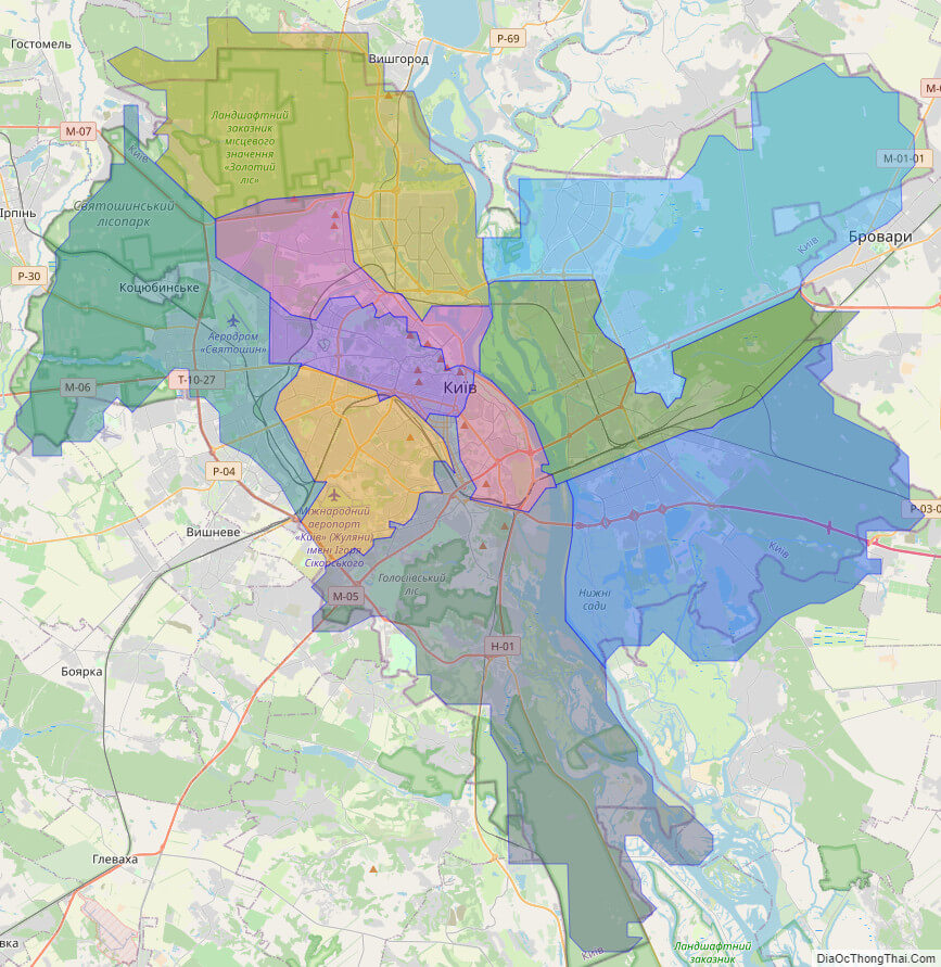
Online subdivision map of Kiev city
Kiev City, the capital and largest city of Ukraine, is a hub of cultural, political, and economic activity. To fully understand and explore the city’s complex network of sub-administrative units, an online subdivision map can be an invaluable tool.
Through the use of an online base map, such as OpenStreetMap or satellite imagery, users can examine the city and its various districts in great detail. The map includes a cover layer with different colors to show the borders and boundaries of each area, allowing for easy differentiation between them.
Zooming in and out of the map provides a closer look at Kiev’s diverse neighborhoods, landmarks, and public spaces, including the iconic Maidan Nezalezhnosti (Independence Square), the picturesque Andriyivskyy Descent, and the sprawling Hydropark.
In addition to physical features, the online subdivision map can also provide information on key demographic and economic data for each district, such as population size, median income, and employment rates. This can be useful for researchers, policymakers, and business owners alike.
By utilizing an online subdivision map of Kiev City, users can gain a deeper understanding of the city’s complex urban landscape and identify areas of interest for further exploration.
Click on ![]() to view map in "full screen" mode.
to view map in "full screen" mode.
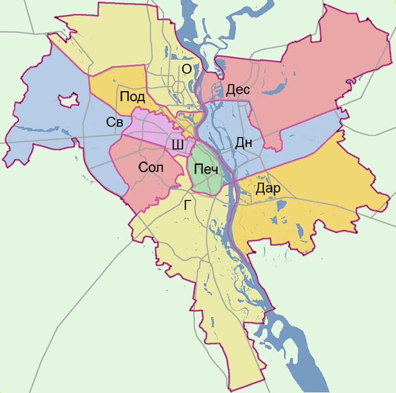
List administrative sub-division of Kiev city
| # | Name | Type |
|---|---|---|
| 1 | Darnyts’kyi | Raion |
| 2 | Desnians’kyi | Raion |
| 3 | Dniprovs’kyi | Raion |
| 4 | Holosiïvs’kyi | Raion |
| 5 | Obolons’kyi | Raion |
| 6 | Pechers’kyi | Raion |
| 7 | Podil’s’kyi | Raion |
| 8 | Shevchenkivs’kyi | Raion |
| 9 | Solomians’kyi | Raion |
| 10 | Sviatoshyns’kyi | Raion |
Explaination:
- Mis’ka Rada: City municipalities (governed by a mayor and a city council)
- Misto: city at least 10,000 people (not a town).
- Raion: often translated as “district”.
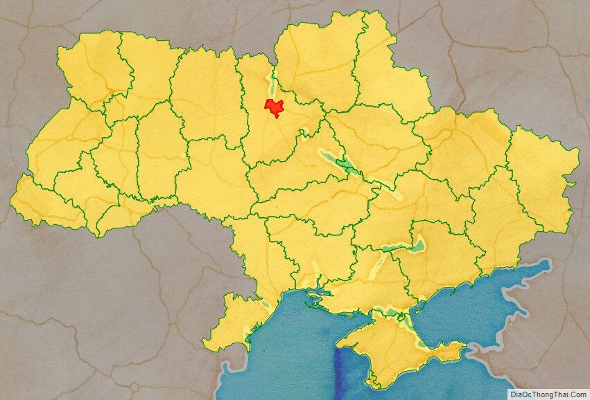
Location map of Kiev city, Ukraine
Political map of Kiev city

Detail map of Kiev city
Kiev city streeet map

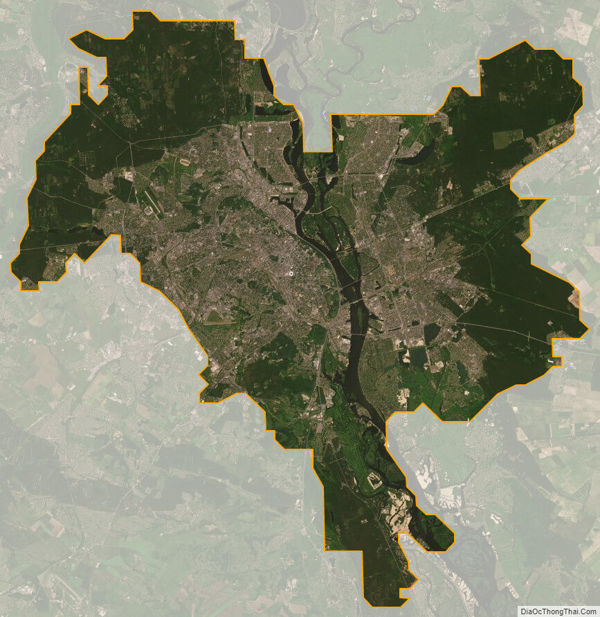
Kiev city satellite map