Political Map of Hoc Mon district – HCMC Interactive online map of Hoc Mon District. Source: Database of Global Administrative Areas, Global Map of Vietnam ©ISCGM, Ministry of Nutural Resources and Environment – Vietnam.Base Map Layer: Open Street Map (OSM), Arcgisonline, Google Map, Wmflabs. Large scale maps of Hoc Mon District Hoc Mon location map ... Read more
Map of all districts of Vietnam
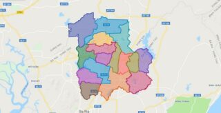
Political Map of Chau Duc district – Ba Ria Vung Tau Interactive online map of Chau Duc District. Source: Database of Global Administrative Areas, Global Map of Vietnam ©ISCGM, Ministry of Nutural Resources and Environment – Vietnam.Base Map Layer: Open Street Map (OSM), Arcgisonline, Google Map, Wmflabs. Large scale maps of Chau Duc District Chau ... Read more
Political Map of Nha Be district – HCMC Interactive online map of Nha Be District. Source: Database of Global Administrative Areas, Global Map of Vietnam ©ISCGM, Ministry of Nutural Resources and Environment – Vietnam.Base Map Layer: Open Street Map (OSM), Arcgisonline, Google Map, Wmflabs. Large scale maps of Nha Be District Nha Be location map ... Read more
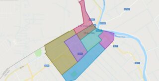
Political Map of Chau Doc city – An Giang Interactive online map of Chau Doc City. Source: Database of Global Administrative Areas, Global Map of Vietnam ©ISCGM, Ministry of Nutural Resources and Environment – Vietnam.Base Map Layer: Open Street Map (OSM), Arcgisonline, Google Map, Wmflabs. Large scale maps of Chau Doc City Chau Doc location ... Read more
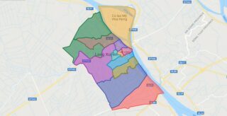
Political Map of Long Xuyen city – An Giang Interactive online map of Long Xuyen City. Source: Database of Global Administrative Areas, Global Map of Vietnam ©ISCGM, Ministry of Nutural Resources and Environment – Vietnam.Base Map Layer: Open Street Map (OSM), Arcgisonline, Google Map, Wmflabs. Large scale maps of Long Xuyen City Long Xuyen location ... Read more
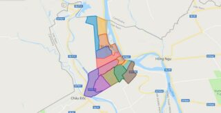
Political Map of Tan Chau town – An Giang Interactive online map of Tan Chau Town. Source: Database of Global Administrative Areas, Global Map of Vietnam ©ISCGM, Ministry of Nutural Resources and Environment – Vietnam.Base Map Layer: Open Street Map (OSM), Arcgisonline, Google Map, Wmflabs. Large scale maps of Tan Chau Town Tan Chau location ... Read more
Political Map of District 12 – HCMC Interactive online map of District 12. Source: Database of Global Administrative Areas, Global Map of Vietnam ©ISCGM, Ministry of Nutural Resources and Environment – Vietnam.Base Map Layer: Open Street Map (OSM), Arcgisonline, Google Map, Wmflabs. Large scale maps of District 12 District 12 location map District 12 street ... Read more
Political Map of Binh Tan district – HCMC Interactive online map of Binh Tan Urban District. Source: Database of Global Administrative Areas, Global Map of Vietnam ©ISCGM, Ministry of Nutural Resources and Environment – Vietnam.Base Map Layer: Open Street Map (OSM), Arcgisonline, Google Map, Wmflabs. Large scale maps of Binh Tan Urban District Binh Tan ... Read more
Political Map of Binh Thanh district – HCMC Interactive online map of Binh Thanh Urban District. Source: Database of Global Administrative Areas, Global Map of Vietnam ©ISCGM, Ministry of Nutural Resources and Environment – Vietnam.Base Map Layer: Open Street Map (OSM), Arcgisonline, Google Map, Wmflabs. Large scale maps of Binh Thanh Urban District Binh Thanh ... Read more
Political Map of Go Vap district – HCMC Interactive online map of Go Vap Urban District. Source: Database of Global Administrative Areas, Global Map of Vietnam ©ISCGM, Ministry of Nutural Resources and Environment – Vietnam.Base Map Layer: Open Street Map (OSM), Arcgisonline, Google Map, Wmflabs. Large scale maps of Go Vap Urban District Go Vap ... Read more
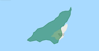
Political Map of Bach Long Vi Island – Hai Phong city Interactive online map of Bach Long Vi District. Source: Database of Global Administrative Areas, Global Map of Vietnam ©ISCGM, Ministry of Nutural Resources and Environment – Vietnam.Base Map Layer: Open Street Map (OSM), Arcgisonline, Google Map, Wmflabs. Large scale maps of Bach Long Vi ... Read more
Political Map of Phu Nhuan district – HCMC Interactive online map of Phu Nhuan Urban District. Source: Database of Global Administrative Areas, Global Map of Vietnam ©ISCGM, Ministry of Nutural Resources and Environment – Vietnam.Base Map Layer: Open Street Map (OSM), Arcgisonline, Google Map, Wmflabs. Large scale maps of Phu Nhuan Urban District Phu Nhuan ... Read more