Political Map of District 10 – HCMC Interactive online map of District 10. Source: Database of Global Administrative Areas, Global Map of Vietnam ©ISCGM, Ministry of Nutural Resources and Environment – Vietnam.Base Map Layer: Open Street Map (OSM), Arcgisonline, Google Map, Wmflabs. Large scale maps of District 10 District 10 location map District 10 street ... Read more
Map of all districts of Vietnam
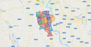
Political Map of District 11 – HCMC Interactive online map of District 11. Source: Database of Global Administrative Areas, Global Map of Vietnam ©ISCGM, Ministry of Nutural Resources and Environment – Vietnam.Base Map Layer: Open Street Map (OSM), Arcgisonline, Google Map, Wmflabs. Large scale maps of District 11 District 11 location map District 11 street ... Read more
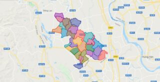
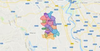
Political Map of Soc Son district – Ha Noi Interactive online map of Soc Son District. Source: Database of Global Administrative Areas, Global Map of Vietnam ©ISCGM, Ministry of Nutural Resources and Environment – Vietnam.Base Map Layer: Open Street Map (OSM), Arcgisonline, Google Map, Wmflabs. Large scale maps of Soc Son District Soc Son location ... Read more
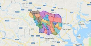
Political Map of Kien Thuy district – Hai Phong city Interactive online map of Kien Thuy District. Source: Database of Global Administrative Areas, Global Map of Vietnam ©ISCGM, Ministry of Nutural Resources and Environment – Vietnam.Base Map Layer: Open Street Map (OSM), Arcgisonline, Google Map, Wmflabs. Large scale maps of Kien Thuy District Kien Thuy ... Read more
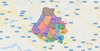
Political Map of Thach That district – Ha Noi Interactive online map of Thach That District. Source: Database of Global Administrative Areas, Global Map of Vietnam ©ISCGM, Ministry of Nutural Resources and Environment – Vietnam.Base Map Layer: Open Street Map (OSM), Arcgisonline, Google Map, Wmflabs. Large scale maps of Thach That District Thach That location ... Read more
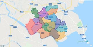
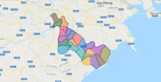
Political Map of Thuy Nguyen district – Hai Phong city Interactive online map of Thuy Nguyen District. Source: Database of Global Administrative Areas, Global Map of Vietnam ©ISCGM, Ministry of Nutural Resources and Environment – Vietnam.Base Map Layer: Open Street Map (OSM), Arcgisonline, Google Map, Wmflabs. Large scale maps of Thuy Nguyen District Thuy Nguyen ... Read more
Political Map of Thanh Oai district – Ha Noi Interactive online map of Thanh Oai District. Source: Database of Global Administrative Areas, Global Map of Vietnam ©ISCGM, Ministry of Nutural Resources and Environment – Vietnam.Base Map Layer: Open Street Map (OSM), Arcgisonline, Google Map, Wmflabs. Large scale maps of Thanh Oai District Thanh Oai location ... Read more
Political Map of Tien Lang district – Hai Phong city Interactive online map of Tien Lang District. Source: Database of Global Administrative Areas, Global Map of Vietnam ©ISCGM, Ministry of Nutural Resources and Environment – Vietnam.Base Map Layer: Open Street Map (OSM), Arcgisonline, Google Map, Wmflabs. Large scale maps of Tien Lang District Tien Lang ... Read more
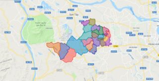
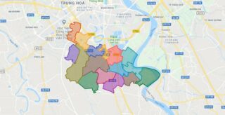
Political Map of Thanh Tri district – Ha Noi Interactive online map of Thanh Tri District. Source: Database of Global Administrative Areas, Global Map of Vietnam ©ISCGM, Ministry of Nutural Resources and Environment – Vietnam.Base Map Layer: Open Street Map (OSM), Arcgisonline, Google Map, Wmflabs. Large scale maps of Thanh Tri District Thanh Tri location ... Read more
Political Map of Vinh Bao district – Hai Phong city Interactive online map of Vinh Bao District. Source: Database of Global Administrative Areas, Global Map of Vietnam ©ISCGM, Ministry of Nutural Resources and Environment – Vietnam.Base Map Layer: Open Street Map (OSM), Arcgisonline, Google Map, Wmflabs. Large scale maps of Vinh Bao District Vinh Bao ... Read more

Political Map of Thuong Tin district – Ha Noi Interactive online map of Thuong Tin District. Source: Database of Global Administrative Areas, Global Map of Vietnam ©ISCGM, Ministry of Nutural Resources and Environment – Vietnam.Base Map Layer: Open Street Map (OSM), Arcgisonline, Google Map, Wmflabs. Large scale maps of Thuong Tin District Thuong Tin location ... Read more
Political Map of Ung Hoa district – Ha Noi Interactive online map of Ung Hoa District. Source: Database of Global Administrative Areas, Global Map of Vietnam ©ISCGM, Ministry of Nutural Resources and Environment – Vietnam.Base Map Layer: Open Street Map (OSM), Arcgisonline, Google Map, Wmflabs. Large scale maps of Ung Hoa District Ung Hoa location ... Read more