Map of Urban Honolulu CDP

Map of Urban Honolulu CDP

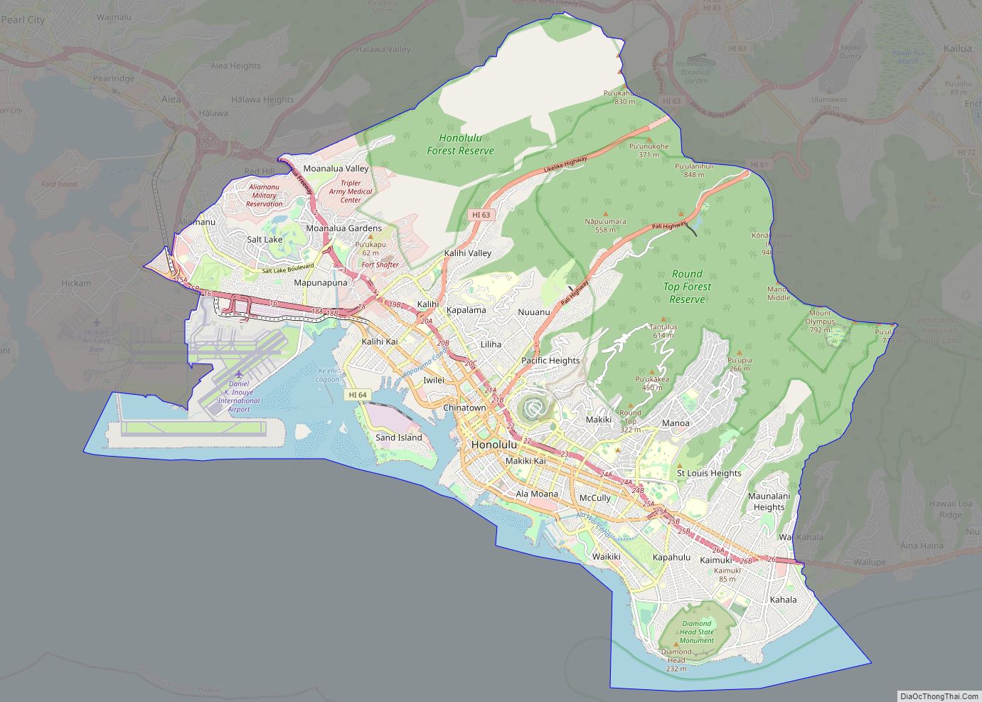
Urban Honolulu CDP overview: Name: Urban Honolulu CDP LSAD Code: 57 LSAD Description: CDP (suffix) State: Hawaii County: Honolulu County FIPS code: 1571550 Explore the streets of Honolulu with this interactive Google Map of Honolulu. Take a journey to the state capital and discover the many attractions and special places that make this a great … Read more

Map of Kailua CDP

Map of Kailua CDP

Kailua /kaɪˈluːə/ (Hawaiian pronunciation: [kɐjˈluwə]) is a census-designated place (CDP) in Honolulu County, Hawaii, United States. It lies in the Koʻolaupoko District of the island of Oʻahu on the windward coast at Kailua Bay. It is in the judicial district and the ahupua’a named Ko’olaupoko. It is 12 miles (19 km) northeast of Honolulu – over Nu‘uanu … Read more

Map of East Honolulu CDP

Map of East Honolulu CDP

East Honolulu is a census-designated place (CDP) located in Honolulu County, Hawaii, United States. As of the 2020 Census, the CDP had a population of 50,922, making it the 2nd most populated CDP in Hawaii, behind Honolulu. East Honolulu CDP overview: Name: East Honolulu CDP LSAD Code: 57 LSAD Description: CDP (suffix) State: Hawaii County: … Read more

Map of Kauai island

Kauai island overview: Name: Kauai island State: Hawaii Explore Kauai Island like never before with our collection of maps. Whether you’re looking for a detailed map of Kauai or a simple overview of the island, you’re sure to find something that suits your needs. Discover the beauty and charm of Kauai with our Kauai Island … Read more

Map of Oahu island

Oahu island overview: Name: Oahu island State: Hawaii Let’s explore the island of Oahu with this interactive map. It features highways, roads, places of interest, and things to do. Get better acquainted with a detailed map of Oahu, Hawaii provided by Google Maps. Oahu is Hawaii’s third-largest island and is sometimes nicknamed the “Gathering Place”. … Read more

Map of Maui island

Maui island overview: Name: Maui island State: Hawaii Explore Maui’s unique geography with our interactive map of the island. Our Maui map collection includes roads, landmarks, and a list of things to do. Whether you’re looking for a secluded beach or a fun activity, you’ll find it all on our map. If you’re planning a … Read more

Map of Ahuimanu CDP

Map of Ahuimanu CDP

Ahuimanu or ʻĀhuimanu (Hawaiian pronunciation: [ʔaːhuwiˈmɐnu]) is a census-designated place (CDP) in the City & County of Honolulu, Hawaii, United States, on the island of Oahu. In Hawaiian ʻāhui-manu means “cluster of birds”. Ahuimanu is spread out beneath the steep windward pali (cliff face) of the Koolau mountain and separated by a low ridge from Heeia … Read more

Map of Ainaloa CDP

Map of Ainaloa CDP

ʻĀinaloa or Ainaloa is a census-designated place (CDP) in Hawaiʻi County, Hawaiʻi, United States, and is located in the District of Puna. The population was 3,609 at the 2020 census. The population had increased to 2,965 at the 2010 census. Ainaloa CDP overview: Name: Ainaloa CDP LSAD Code: 57 LSAD Description: CDP (suffix) State: Hawaii … Read more

Map of Aiea CDP

Map of Aiea CDP

Aiea (/aɪˈeɪə/; Hawaiian: ʻAiea, pronounced [ʔɐjˈɛjə]) is a census-designated place (CDP) located in the City and County of Honolulu, Hawaii, United States. As of the 2010 Census, the CDP had a total population of 9,338. Aiea CDP overview: Name: Aiea CDP LSAD Code: 57 LSAD Description: CDP (suffix) State: Hawaii County: Honolulu County Elevation: 249 ft (76 m) … Read more

Map of Anahola CDP

Map of Anahola CDP

Anahola (literally “deadly winds” in Hawaiian) is a census-designated place (CDP) in Kauaʻi County, Hawaiʻi, United States. The population was 2,311 at the 2020 census, up from 1,932 at the 2000 census. Anahola CDP overview: Name: Anahola CDP LSAD Code: 57 LSAD Description: CDP (suffix) State: Hawaii County: Kauai County Elevation: 30 ft (9 m) Total Area: … Read more

Map of Eden Roc CDP

Map of Eden Roc CDP

Eden Roc is a census-designated place (CDP) in Hawaiʻi County, Hawaiʻi, United States, located in the District of Puna. The population was 942 at the 2010 census, up from 451 at the 2000 census. Eden Roc CDP overview: Name: Eden Roc CDP LSAD Code: 57 LSAD Description: CDP (suffix) State: Hawaii County: Hawaii County Elevation: … Read more